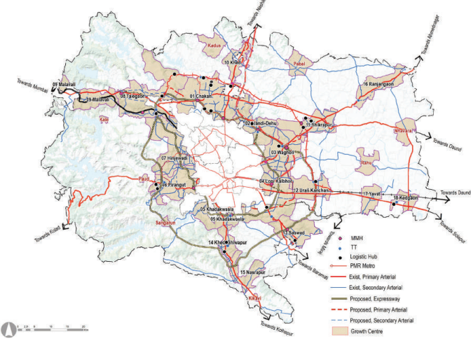
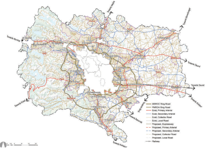
The planning process is complicated due to the existing prevailing conditions, the involvement of various authorities, the fallout of the Regional Plan proposals, and honouring the building permissions thereof. The following actions provide a guide for the preparation of the transportation plan of PMR.
Existing Road Network as a Base Network
PWD district roads master plan 2001-2021 is generally followed. Classified roads such as national highways (NH), state highway (SH), major district roads (MDR), other district roads (ODR), village roads (VR) are duly considered while proposing the transport network. Further, roads developed by government authorities, roads part of Regional Plan, roads within MIDC industrial areas, private internal roads are also considered. All these roads included in the ELU database form the basis of the proposed road network planning.
Connectivity with Adjoining Development Plans
Connectivity with an existing and proposed road network of development plans/master plans of PMC, PCMC, seven municipal councils, three cantonments, MIDC layouts/industrial layouts, PMRDA TP schemes, integrated townships, approved building permissions have been considered.
Approved Projects by various authorities and PMRDA Approved Layouts
Proposals from government authorities such as NHAI, PWD, MSRDC, railways, PMRDA, MIDC, MADC etc. have been considered in the proposed transportation plan. However, these authorities reserve the right to change their respective alignments in consultation with concerned stakeholders at a later stage.
Proposed road network within layouts and ITPS is considered along with its continuity with the surrounding iwhile proposing the transport network.
Demands from Citizens, Public Representatives, Government Bodies
PMRDA has received several applications from residents, elected representatives and government agencies regarding their requirements of amendments in roads passing through or aligning certain properties. These have been studied and considered in relation to CTTS study as well as Development Plan planning intent and incorporated accordingly. PMRDA has also received letters from government authorities regarding the incorporation of their transport amenity requirements.
Physical Features Considered While Planning
While planning for the proposed transport network, due cognisance was given to the physical features such as forests, water bodies and their buffers, hilltop hill slopes and green zones around rivers. Contours and levels played an essential role in the profiling of road alignments. Constrained sites such as defence, military and special planning areas were bypassed. Roads were designed following the terrain, plot boundaries and integrating with the proposed land use. Bypass roads have been proposed around Goathans and congested areas to avoid congestion.
RP Proposals and their Criteria
In general, Regional Plan 1997 road alignments, hierarchy and ROWs are adhered to. However, after analysing existing information based on high-resolution imagery, 0.5 m contour data and existing land use, certain amendments were required to the road network proposed in Regional Plan 1997.
Following criteria were utilized while considering RP roads:
-
An alternative road is proposed if the RP road alignment is passing through a settlement that is fully built-up, but in a case where alignment is important, then the old alignment is retained as per RP even if it is incompatible with structures; also, an additional alternative road is further provided.
-
Existing (i.e. already developed) road alignment is considered when the RP road is aligned in close proximity to this existing road.
-
Roads proposed by other planning authorities which are differing from RP alignment are considered.
-
An alternative route is proposed to the RP roads, which pass through restricted areas like forests and geographical constraints like hills, water bodies etc.
-
Roads in approved layouts, which either adjoin RP roads or where an RP road passes through the structures, are followed.
-
Revised ROW is proposed for RP roads passing through existing settlements such that the proposed road is implementable.
-
Unimplemented RP roads passing through greenfield areas that do not cater to any existing settlement or which are not in line with proposed transportation strategies are realigned/downgraded to suit the planning intent.