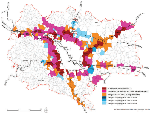
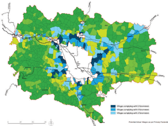
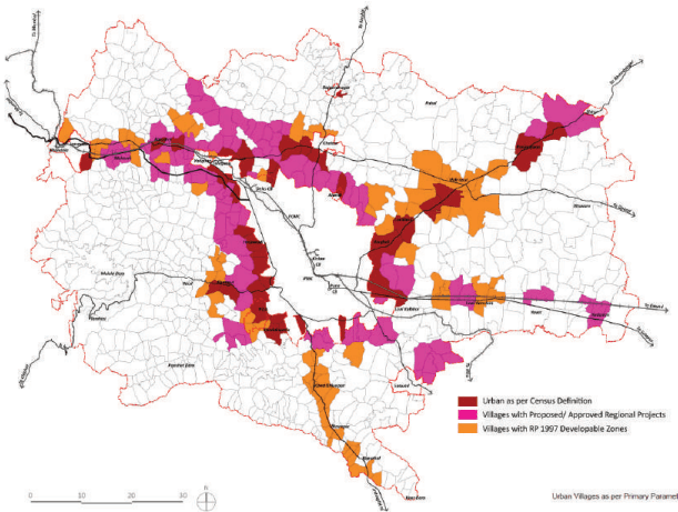
Considering the vastness of PMR, it is imperative to strategically prioritise development planning and investment efforts on certain villages where urban development pressure is already high or anticipated in the near future. Prioritisation needs to be based on specific parameters such as past demographic growth, availability of essential utilities and amenities, accessibility, etc. Therefore, 13 such parameters are identified to facilitate the prioritisation of urbanised and urbanising villages, to form part of a Growth Centre, for which a Development Plan needs to be prepared. Each village is assessed using these parameters, and a cumulative score is enumerated for each village determining its potential. Table 9.1 represents a snapshot of 814 villages and their performance against 13 parameters. These parameters are grouped into Primary and Secondary Parameters, and further details are described below:
Figure 9.1: Urbanisation Potential Assessment- Process
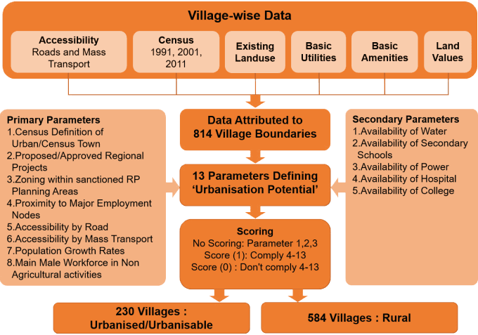
No scoring means village considered as Urban if it satisfies Parameter 1,2,3
Chapter 9: Urbanisation Potential Assessment
| 1 | 2 | 3 | 4 | 5 | 6 | 7 | 8 | 9 | 10 | 11 | 12 | 13 | Scores | ||||
| No | CODE | Revenue_Name | Regional Projects | Census Urban/Rural | RP Buildable Landuses | Proximity to Employment Nodes | Access by Road | Access by Mass Transport | Population Growth Rate 2001-11 | Non Agricultural Workforce | Availability of Sec. Schools | Availability of Colleges | Water Supply | Availability if Electric Sub Station | Availability of Health Facilities | Scores_4 to 8 | Scores4 to 13 |
| 6 | 556037 | Adhe kh. | R | 1 | 1 | 0 | 0 | 0 | 0 | 0 | 0 | 0 | 0 | 2 | - | ||
| 8 | 556254 | Agalambe | R | RP | 1 | 0 | 1 | 0 | 0 | 0 | 1 | 1 | 0 | 0 | 2 | - | |
| 10 | 555937 | Ahirvade | RS | R | RP | 0 | 0 | 0 | 1 | 1 | 0 | 0 | 0 | 0 | 0 | 2 | - |
| 14 | 556029 | Akurdi | RR | R | RP | 1 | 1 | 0 | 0 | 1 | 0 | 0 | 0 | 0 | 0 | 3 | 3 |
| 15 | 555852 | Alandi | RR | U | RP | 1 | 1 | 1 | 1 | 1 | 1 | 0 | 0 | 0 | 1 | 5 | 7 |
| 20 | 555877 | Ambale | R | 1 | 1 | 0 | 1 | 0 | 0 | 0 | 0 | 0 | 0 | 3 | 3 | ||
| 21 | 556136 | Ambarwet | R | RP | 1 | 1 | 1 | 0 | 0 | 0 | 0 | 1 | 0 | 1 | 3 | 4 | |
| 26 | 556163 | Ambegaon | R | 1 | 0 | 1 | 0 | 0 | 0 | 0 | 1 | 0 | 0 | 2 | - | ||
| 30 | 556028 | Ambi | RR | R | RP | 1 | 1 | 0 | 1 | 0 | 0 | 1 | 0 | 0 | 0 | 3 | 4 |
| 32 | 555576 | Amdabad | R | 1 | 1 | 0 | 0 | 0 | 1 | 0 | 0 | 0 | 0 | 2 | - | ||
| 37 | 555658 | Andhalgaon | R | 0 | 1 | 0 | 1 | 0 | 0 | 0 | 0 | 0 | 0 | 2 | - | ||
| 38 | 555980 | Apati | R | 0 | 0 | 0 | 1 | 1 | 0 | 0 | 0 | 0 | 1 | 2 | - | ||
| 43 | 556280 | Arvi | R | 1 | 0 | 1 | 0 | 0 | 1 | 0 | 0 | 0 | 0 | 2 | - | ||
| 51 | 555975 | Aundhe kh. | R | 0 | 1 | 0 | 0 | 1 | 1 | 0 | 0 | 0 | 0 | 2 | - | ||
| 770 | 556390 | Varwand | RS | R | 0 | 1 | 1 | 0 | 0 | 1 | 1 | 1 | 0 | 1 | 2 | - | |
| 777 | 556674 | Velu | R | RP | 1 | 1 | 1 | 0 | 0 | 0 | 1 | 0 | 0 | 0 | 3 | 4 | |
| 781 | 556204 | Vitthal Nagar | U | RP | 1 | 1 | 1 | 1 | 1 | 0 | 0 | 0 | 0 | 0 | 5 | 5 | |
| 783 | 556150 | Vitthalwadi | R | 1 | 0 | 1 | 0 | 0 | 0 | 0 | 0 | 0 | 0 | 2 | - | ||
| 785 | 556220 | Wade Bolhai | R | 0 | 1 | 1 | 0 | 0 | 1 | 1 | 0 | 0 | 1 | 2 | - | ||
| 786 | 556212 | Wadhu Kh. | R | RP | 1 | 0 | 1 | 1 | 0 | 0 | 0 | 0 | 1 | 0 | 3 | 4 | |
| 789 | 556327 | Wagholi | RR,TPS,TS | U | RP | 1 | 1 | 1 | 1 | 1 | 1 | 1 | 1 | 0 | 1 | 5 | 8 |
| 792 | 555630 | Wajewadi | R | 1 | 1 | 1 | 0 | 0 | 0 | 0 | 0 | 0 | 1 | 3 | 4 | ||
| 794 | 556365 | Wakhari | R | 0 | 1 | 0 | 1 | 0 | 0 | 0 | 0 | 0 | 0 | 2 | - | ||
| 796 | 555837 | Waki Kh. | R | RP | 1 | 1 | 1 | 1 | 1 | 1 | 1 | 0 | 0 | 1 | 5 | 8 | |
| 798 | 555946 | Waksai | R | RP | 0 | 1 | 0 | 1 | 1 | 0 | 1 | 0 | 0 | 1 | 3 | 5 | |
| 806 | 555822 | Warale | R | 1 | 1 | 0 | 0 | 0 | 0 | 0 | 0 | 0 | 1 | 2 | - | ||
| 809 | 555824 | Wasuli | R | RP | 1 | 1 | 0 | 0 | 0 | 0 | 0 | 0 | 1 | 0 | 2 | - | |
| 812 | 556353 | Yawat Station | RS | R | 0 | 1 | 1 | 0 | 0 | 0 | 0 | 0 | 1 | 0 | 2 | - | |
| 815 | 555828 | Yevalewadi | R | 1 | 1 | 1 | 0 | 0 | 0 | 0 | 0 | 0 | 1 | 3 | 4 | ||
Primary Parameters
Primary parameters identify villages which can be considered as ‘urban’ or ‘potential urban’.
1. Census Definition of Urban/Census Town
Villages are categorised as ‘urban’ based on Census definition, i.e. a minimum population of 5,000, at least 75 percent of the male working population engaged in non-agricultural pursuits and a population density of at least 400 persons per sq km.
2. Proposed/Approved Regional Projects
Proposed/approved regional projects such as PMRDA Ring Road, Railway up-gradation, MIDC’s future expansion, TP Schemes and Townships are likely to trigger future urbanisation.
Recognising this, villages are categorised as ‘potential urban’, in case such projects are situated in the village or passing through it.
3. Zoning within Sanctioned RP Planning Areas
Zoning plans of erstwhile Growth Centres of RP 1997 have been sanctioned, and it has been used as a basis while granting the development permissions. Therefore, a village is deemed ‘potential urban’ (to be included in Urban Growth Centres), if it was part of RP Planning Areas and zoning such as residential/industrial was proposed over there.
Two hundred ten (210) villages satisfying either of parameters 1, 2, 3 are selected for inclusion in Urban Growth Centres.
Remaining villages are tested against parameter 4-8 as explained further.
4. Proximity to Major Employment Nodes
Villages situated within 7 km from existing major employment nodes such as MIDC estates, industrial clusters, IT Parks, and road access are considered ‘potential urban’. 7 km refers to average trip length for work in PMR, as per CMP study.
5. Accessibility by road
As per CMP GIS data, most of the villages are accessed by roads with maximum 1 or 2 lanes. A village is considered ‘potential urban’ if it has better accessibility, i.e. more than two lanes (>7 m).
6. Accessibility by Mass Transport
Lack of adequate penetration of mass transport is one of the critical problems faced by the Study Area. Therefore accessibility by mass transport (intracity/intercity level) is considered as a positive indicator supporting future urbanisation of such villages.
7. Population Growth Rates
Growth rates of the majority of the villages in the Study Area are either stabilising or declining. Therefore, a village showing greater than average growth rates of Study Area (>26%) is considered as a positive indicator supporting future urbanisation of such villages.
8. Main Male Workforce in Non-Agricultural activities
This is considered partly in the Census definition of an urban/census town. However, there is a risk of not recognising a village that represents any of the three criteria. Out of three, non-agricultural primary male workforce employment is a clear indicator of urbanisation. Population density is a variable that depends on the size of the village, and not many villages are >5000 population. Therefore, the primary male workforce in non-agricultural activities is considered a parameter to categorise a village as ‘urban’.
Secondary Parameters
Secondary parameters minimize the risk of missing out and improve the assigned score for certain villages if most of the primary parameters are not applicable.
9. Availability of Water
Many villages in the Study Area and some of the urbanised localities within municipal corporations suffer from water scarcity. Village wise projection of population by the year 2018 and per capita consumption rates specified by MWRRA are used to project estimated demand by 2018. It is compared to the village wise allocation of water as obtained from MJP and ZP. Based on this analysis, villages with surplus water allocation, i.e. capacity to absorb future population are identified and categorised as ‘potential urban’.
10. Availability of Secondary Schools
Most of the Study Area villages have adequate primary schools considering village wise schools as per ZP and proposed planning norms. Based on these criteria, only a few villages have adequate secondary schools. For urban households, proximity to a secondary school is considered an essential measure before choosing a particular locality. Therefore, villages with surplus secondary schools would become an added advantage for the
Chapter 9: Urbanisation Potential Assessment
village in attracting a higher migrant population. Therefore, such villages are categorised as ‘potential urban’.
11. Availability of Power
Electrical transmission substations are key to connect power grids to the distribution network, and their location coordinates are obtained from MSETCL. Such substations are likely to boost urban development by serving industrial/commercial/residential uses that generate higher electricity demand. Presence of electrical transmission substation could raise urbanisation prospects of villages where it is located. Therefore it is considered as a parameter to categorise a village as ‘potential urban’.
12. Availability of Hospital
Proximity to a hospital raises urbanisation prospects of a locality. Therefore, a village with a hospital is considered a parameter to classify it as a ‘potential urban.’
13. Availability of College
In the case of Pune, urbanisation of many localities have been either initiated or spurred with higher education institutes. Therefore, it is considered as one of the parameters to categorise villages as ‘potential urban’.
Parameters 9 to 13 are applied only to 235 villages that are already identified based on parameter 1, 2, 3 and villages scoring >3 as per parameters 4 to 8. A score of 1 is assigned for each parameter if it satisfies parameter 9-13. Zero is assigned otherwise. As parameters 9-13 are secondary parameters, they are used to identify central/ core villages within a group of already identified villages.