Social infrastructure covers a range of services and facilities that meet local and strategic needs and contribute towards a good quality of life. It includes health provisions, education, community facilities, recreational and open spaces, sports facilities and emergency facilities. Its availability, extent and sophistication are crucial measures of the overall development and quality of life of any region. Social infrastructure plays a pivotal role in fostering strong and inclusive communities. It provides opportunities to bring different groups of people together, contributing to social integration and the desirability of a place.
6.1Institutional Setup
The key organisations providing social infrastructure in Pune Metropolitan Region are:
Urban Local Bodies:
Individual municipal corporations, councils and cantonment boards prepare Development Plans for their respective jurisdictions, which provide a statutory binding to propose and implement social infrastructure facilities as well as operate and maintain those as per the present and future demands of the public realm. Pune Metropolitan Region comprises two municipal corporations, seven municipal councils and three cantonment boards. These Urban Local Bodies have an obligatory duty to establish and maintain education facilities, healthcare facilities, community facilities, open spaces and recreational areas in their respective planning areas.
Zilla Parishad, Pune:
Maharashtra adopted three tiers of the Panchayat Raj System under the Maharashtra Zilla Parishad and Panchayat Samiti Act, 1961. The three-tier Panchayati Raj system included Zilla Parishad at the apex, followed by Panchayat Samiti and Gram Panchayat. Pune Zilla Parishad establishes and maintains primary and secondary educational facilities in the district. Apart from educational facilities, Pune Zilla Parishad also looks after the management of hospitals and other health care facilities in the rural parts of the district.
Gram Panchayat
Gram Panchayat plays an active role in implementing the required social facilities within the premise of a village boundary.
6.2Educational Facilities
Access to high-quality education, which profoundly affects people’s lives, is one of the most powerful ways to break down inequalities and improve social mobility. PMR’s literacy rate stands at 81%, slightly lower than that of Pune district (86.2%) and Maharashtra state (82.3 %).
Currently, there are a total of 2,631 education facilities within PMR. Education facilities are categorised as primary, secondary and tertiary. Primary education includes pre-primary or Anganwadi and primary schools. Secondary education facilities include secondary schools /high school and tertiary facilities include colleges and higher education institutes.
Table 6.1Primary, Secondary and Tertiary Education Facilities - ELU/GIS Database
Taluka
Primary Education Facility
Secondary Education Facility
Tertiary Education Facility
Total Education Facilities
Daund
Numbers
202
30
16
248
Area (ha)
22.57
7.141
21.77
51.48
Purandar
Numbers
84
13
4
101
Area (ha)
11.30
6.398
3.52
21.22
Velhe
Numbers
47
10
1
58
Area (ha)
2.02
0.27
0.10
2.39
Haveli
Numbers
301
105
43
449
Area (ha)
69.31
71.805
194.88
336.00
Mulshi
Numbers
216
65
41
322
Area (ha)
42.00
58.324
296.92
397.24
Khed
Numbers
373
79
8
460
Area (ha)
35.60
14.196
4.79
54.59
Maval
Numbers
382
70
35
487
Area (ha)
44.59
50.404
137.64
232.64
Bhor
Numbers
83
25
11
119
Area (ha)
7.29
3.52
28.21
39.02
Shirur
Numbers
302
74
11
387
Area (ha)
31.04
16.4258
7.00
54.46
Total
Numbers
1,990
471
170
2631
Area (ha)
265.7
228.5
694.8
1189
Source: GIS Database; Survey Data, ELU Database; Department of School Education and Literacy, Ministry of Education GoM, Schoolgis.nic.in
Table 6.2Government Schools and Private Schools - ELU/GIS Database
Taluka
Govt. School
Private School
Trust
Daund
Numbers
168
59
Area (ha)
18.55
32.85
Purandar
Numbers
65
16
Area (ha)
15.97
4.91
Velhe
Numbers
41
9
Area (ha)
2.01
0.2
Haveli
Numbers
192
164
4
Area (ha)
95.92
230.60
1.63
Chapter 6: Social Infrastructure
Numbers Mulshi Area (ha)
16312.68
110391.96
Numbers Khed Area (ha)
31129.91
9524.41
Numbers
344
86
1
Maval
Area (ha)
17.02
208.96
6.34
Numbers
80
29
Bhor
Area (ha)
7.2
31.87
Numbers
260
84
Shirur
Area (ha)
25.19
30.08
Numbers
1624
652
5
Total
Area (ha)
224.45
955.84
7.97
Source: GIS Database; Survey Data, ELU Database; Department of School Education and Literacy, Ministry of Education GoM, Schoolgis.nic.in
PMR is majorly rural in nature, and Zilla Parishad has been active in providing a school in most villages. Out of 2,631 schools, 62% schools are government-run schools while 25% are private schools. Malaval Taluka (487) has the maximum number of schools, followed by Khed (460) and Haveli (449). Mawal, Khed and Shirur Taluka have the maximum number of government schools/ZP Schools, while Haveli and Mulshi have the most private schools. It is also observed that private schools are primarily located along national highways and edging the current urbanisation areas. In contrast, government schools are well spread off into rural areas.
Primary education facility
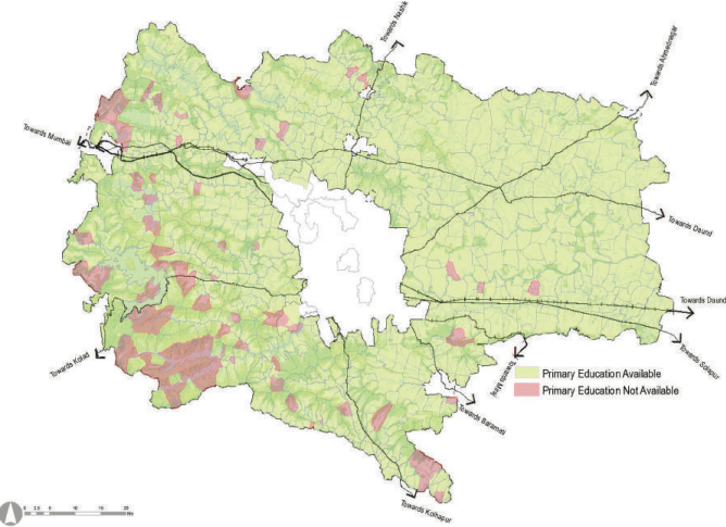
PMR has 1990 primary schools spread across the region. Currently, one school serves 860 people, better than the desired ratio of one school per 5,000 people (as per RP 1997). However, the average area per school is 0.13 ha, which is less than the standards stated in RP 1997.
Table 6.1 explains the taluka wise distribution of primary schools. It is observed that Maval taluka has the maximum number of primary schools (382), followed by Khed taluka (373). Area-wise, Haveli taluka has the highest average area under schools with 0.23 ha per school. In contrast, other talukas have sizes ranging from 0.04 to 0.19 hectares per school.
Figure 6.1: Village Wise Availability of Primary Education Facilities - ELU/GIS Database
Source: GIS Database; Survey Data, ELU Database; Department of School Education and Literacy, Ministry of Education GoM, Schoolgis.nic.in
129 villages are without primary schools, out of which 45 villages lie in the Western Ghats area. The population of some of these villages is also less than 100 people, and thus they share amenities with neighbouring villages.
Secondary education facility
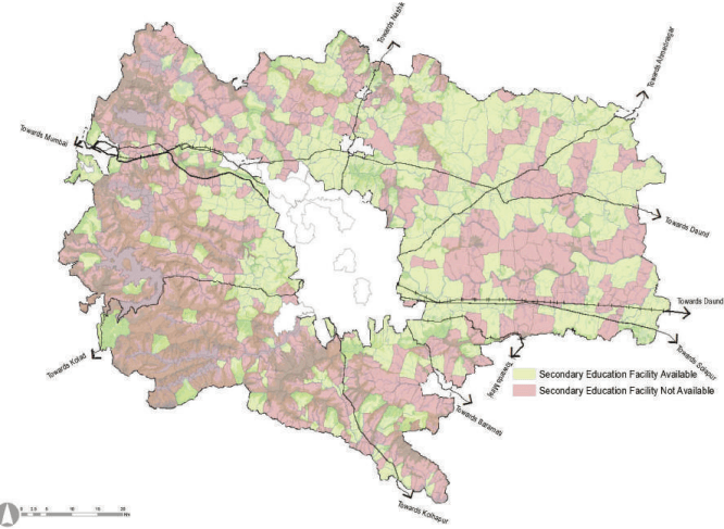
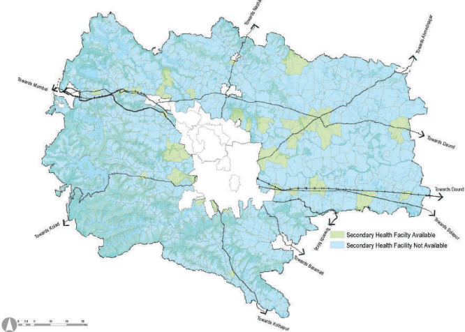
PMR has 471 secondary schools spread across the region. Currently, one school serves 3,634 people, better than the desired ratio of one school per 7,500 people (as per RP 1997). However, the average area per school is 0.48 ha, which is less than the standards stated in RP 1997. The area requirement of these schools is not fulfilled.
Table 6.1 explains the taluka wise distribution of primary schools. It is observed that Haveli taluka has the maximum number of secondary schools (105), followed by Khed taluka (79) and Maval taluka (70).
Out of 557 villages without secondary schools, 126 villages lie in the Western Ghats area. The population of these villages is also less than 100 people, and thus they share amenities with neighbouring villages.
Chapter 6: Social Infrastructure
Figure 6.2: Village Wise Availability of Secondary Schools - ELU/GIS Database
Tertiary Education Facilities
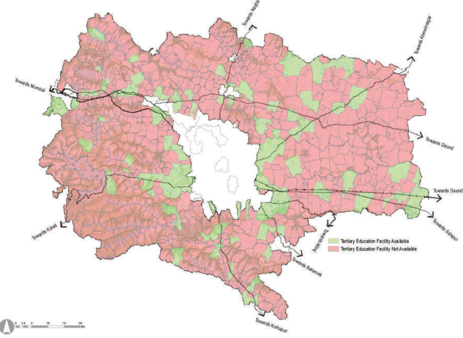
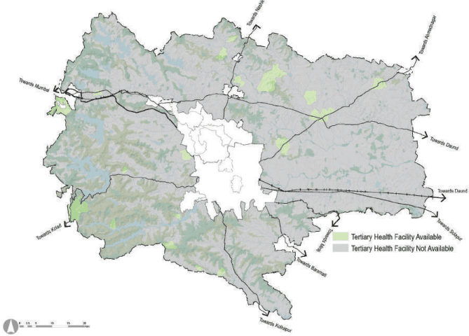
Pune Metropolitan Region has 170 colleges/higher education institutions, with the highest number of establishments in Haveli taluka followed by Mulshi. Table 6.1 gives an overview of available tertiary education facilities in each taluka. Considering the Planning Area population estimated for 2018, there is one tertiary education facility for every 10,067 people.
Table 6.3Taluka Wise Availability of Tertiary Education Facilities - Census 2011
Taluka
Arts and Science College
Engineer-ing College
Medical College
Management Institute
Polytechnic College
Vocational Training Insti-tute/ ITI
Non-Formal Training Centre
Bhor
0
1
0
0
2
0
0
Daund
3
0
0
0
0
2
0
Haveli
14
1
0
0
1
3
0
Khed
1
0
0
0
0
2
0
Mawal
0
0
0
0
0
12
0
Mulshi
1
0
0
0
0
1
0
Purandar
0
0
0
0
0
2
0
Shirur
2
1
0
0
0
6
0
Velhe
0
0
0
0
0
0
0
Total
21
3
0
0
3
28
0
Source: GIS Database; Survey Data, ELU Database; Department of School Education and Literacy, Ministry of Education GoM, Schoolgis.nic.in
Figure 6.3: Village Wise Availability of Tertiary Education Facilities - Census 2011
Source: GIS Database; Survey Data, ELU Database; Department of School Education and Literacy, Ministry of Education GoM, Schoolgis.nic.in; Census 2011
6.3Health Care Facilities
Health care facilities have been categorised into health centres, hospitals and veterinary clinics/hospitals. The health centre forms the first tier of the healthcare system, and it serves the neighbourhoods. These health centres are further classified into Primary Health Centres (PHC) developed by Zilla Parishad and private centres.
Hospitals form the second tier of the healthcare system and serve larger masses at the town level. These hospitals are generally located at district headquarters or the major towns. The rural population has to rely on these hospitals for any specialised diagnosis and treatment. Hospitals are classified into maternity care units, government hospitals and private hospitals.
PMR being majorly rural in character, veterinary clinics and hospitals play an essential role. Veterinary hospitals are generally located at district headquarters or major towns and transport intersections. Table 6.4 gives details of the total healthcare units in PMR.
Haveli (82) has the maximum number of health centres, followed by Shirur and Mawal talukas. Mulshi (0.5 ha per facility) tops the average area per health facility after Haveli (0.6 ha per facility).
Chapter 6: Social Infrastructure
Table 6.4Health Care Facilities in PMR - ELU/GIS database
Taluka
Total Health facility
Health Centre
Hospitals
Veterinary
Primary Health Centre
Private health centre
Maternity
Govt. hos-pitals
Private hospital
Daund
Numbers
42
19
15
3
1
5
3
Area (ha)
5.7
3.3
0.5
0.4
0.7
1.2
0.05
Purandar
Numbers
7
7
0
0
0
0
0
Area (ha)
0.2
0.2
0.00
0
0
0
0
Velhe
Numbers
8
3
1
0
0
0
3
Area (ha)
0.3
0.2
0.1
0
0
0
0.03
Haveli
Numbers
82
16
23
0
0
12
3
Area (ha)
50.4
2.7
1.2
0
0
1.8
0.02
Mulshi
Numbers
49
9
30
1
1
3
2
Area (ha)
22.8
0.6
19.0
0.25
1.6
1.1
0.01
Khed
Numbers
27
6
47
0
9
4
4
Area (ha)
4.5
0.2
3.3
0
3.9
2.7
0.10
Maval
Numbers
51
12
28
0
4
5
2
Area (ha)
7.0
3.2
0.7
0
1.8
1.3
Bhor
Numbers
14
2
8
0
0
1
1
Area (ha)
0.7
0.02
0.3
0
0
1.3
0.09
Shirur
Numbers
69
18
48
2
2
2
1
Area (ha)
1.6
0.3
1.0
0.14
1.4
0.2
0.01
Total
Numbers
349
92
200
6
17
32
19
Area (ha)
93.1
10.7
26.0
0.8
9.4
9.6
0.3
Source: GIS Database; Survey Data, ELU Database; Pune Zilla Parishad.
Health Centres in PMR
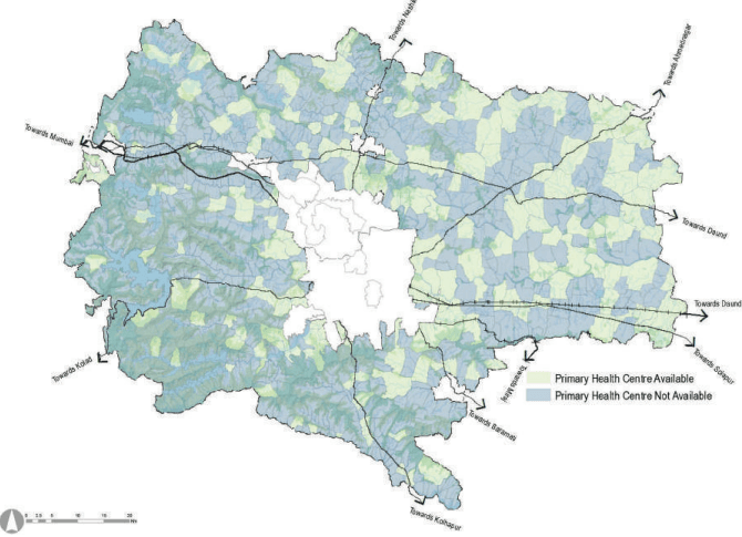
As per the GIS database, PMR has 292 health centres, out of which 31% are PHCs, and 69% are private health centres. The typical character of these private health centres are smaller building footprints or hosted within a few floors of a building, majorly along the national highways. This fact is proven by the average area occupied, which is 0.12 ha per centre.
Shirur (18) has a maximum percentage (19%) of PHCs followed by Haveli (16), while Khed and Shirur have maximum private health centres followed by Haveli.
Figure 6.4: Village Wise Availability of Primary Health Facilities - ELU/GIS Database
Source: GIS Database; Survey Data, ELU Database; Pune Zilla Parishad.
While assessing the availability of health centres, it is observed that for every 5861 people one health centre is available. It is imperative to propose and develop new facilities to cater to the present and future PMR population’s primary healthcare needs.
Hospitals
PMR has 55 hospitals, out of which 58% are private hospitals,31% are government hospitals, and 11% are maternity hospitals. Nine government hospitals are present in Khed along the Pune-Nashik Highway, while four are present in Maval taluka. In terms of private hospitals, Haveli tops the numbers with 12 hospitals. Maternity and child care centres are few in PMR, with only six clinics spread across three talukas.
Analysing penetration of hospitals in PMR reveals that Purandar and Velhe do not have any hospitals. PMR has one hospital for every 31,118 people. At the same time, each maternity and childcare facility caters to 2,85,248 people, clearly indicating its inadequacy.
Veterinary Hospitals
PMR has 19 veterinary hospitals. Each taluka in PMR has a veterinary hospital except Purandar, as only part of taluka lies in PMR. Khed (4) has the maximum number of veterinary facilities, followed by haveli and Velhe, having three each. Mulshi and Mawal have insufficient numbers with only 2 in the entire taluka, while Shirur (1) has the least number of the available facilities.
Chapter 6: Social Infrastructure
Figure 6.5: Village Wise Availability of Hospitals - ELU/GIS database
Figure 6.6: Village Wise Availability of Veterinary facilities - ELU/GIS database
Source: GIS Database; Survey Data, ELU Database; Pune Zilla Parishad.
Source: GIS Database; Survey Data, ELU Database; Department of School Education and Literacy, Ministry of Education GoM, Schoolgis.nic.in
It is observed that the majority of tertiary level facilities/ colleges are available edging the dense development areas or the urbanizing areas and along major transport corridors. Area wise, Mulshi taluka has maximum area per facility which is 7.24 ha/facility while Haveli has 4.53ha/facility, followed by mawal with 35 colleges having 3.93 ha/facility.
6.4Recreational Areas and Facilities
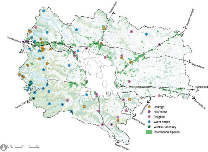
Pune Metropolitan Region is rich in biodiversity and natural heritage with notable tourism sites such as wildlife sanctuaries, forts, religious or pilgrim destinations and hill stations. Pune city adds to the context of PMR. It has many destinations that attract tourists from the entire district and state. Some of these attractions include Shaniwarwada, Dagdusheth Ganpati, Kasba Ganpati, Pataleshwar Caves, Osho Ashram, Pashan Lake, Katraj Snake Park, and so forth.
Recreational areas and facilities have been categorized as following to have a better understanding of requirements and availability.
Forest and wildlife sanctuaries
Lakes and dams
Heritage
Religious sites
Recreational open spaces
Forest and Wildlife Sanctuaries
PMR has a forest cover of about 824.29 sq km and two wildlife sanctuaries (62.19 sq km) - Tamhini Ghat Wildlife Sanctuary and Sudhagad Wildlife Sanctuary. Tamini Ghat and Sudhagad wildlife sanctuaries are home to a rich and diverse selection of flora and fauna. The sanctuaries are home to different species of mammals and birds, including Indian endemic birds, butterfly species, reptiles species, invertebrates, and rare flora species. Apart from this, Tamhini Ghat and Sudhagad have a very scenic beauty which draws tourists and visitors, especially in the monsoons, when waterfalls dot it.
Lakes and Dams
PMR has many lakes, dams and reservoirs, along with rivers and streams. These water bodies cover 37,514 ha of area, which is about 6.1% of the PMR area. Popular lakes and dams include Pashan lake, Bhushi dam, Mulshi dam, Khadakwasla dam, Varasgaon dam, Panshet dam, Kund mala and Mastani lake. These lakes and dams have tourism development around them and in their proximity.
Heritage
PMR has overall 12 protected monuments of national importance and 12 protected monuments of state importance. The famous protected heritage structures of national importance are Bhaja and Karla caves, Lohgad fort, Pataleshwar cave temple, Shaniwarwada, Visapur fort and Agakhan Palace building. Whereas, Sinhagad, Koirigad, Mahatma Phule Wada, Vishrambaug Wada, Hutatma Rajguru Wada, Grave of Mastani are some of the popular protected heritage sites of state importance. Rajmachi, Tung fort, Tikona fort, Bedse caves, Purandar fort, Malhargad fort and Lal Mahal are other prominent heritage sites in PMR.
Religious Sites
Pune is called the cultural capital of Maharashtra. PMR houses a lot of religious places of different religions. The more prominent sacred places in PMR are Chaturshrungi temple, Alandi temple, Mahaganpati temple in Ranjangaon, Prati Balaji, Prati Shirdi, Parvati Hill temple, Dilawar Khan Masjid and tomb, Kamar Ali Darvesh Dargah at Khed Shivapur, Dagdusheth Ganpati and Dehu-Gatha Mandir.
Recreational Open Spaces
Recreational open spaces include parks, gardens and open spaces. Parks are green landscaped areas that act as the lungs of the city. Parks and gardens provide pollution-free and pedestrian-friendly areas for a varied range of social activities. Open spaces include publicly accessible spaces that can accommodate multiple active recreational uses such as expos, exhibitions, playgrounds, etc. Unlike parks and gardens, open spaces need not be filled with vegetation. At present, 588 ha of land cover is under recreational use as per the ELU database.
Chapter 6: Social Infrastructure
Figure 6.7: Recreational Spaces in PMR
Source: GIS Database; Survey Data, ELU Database.
6.5Fire Services
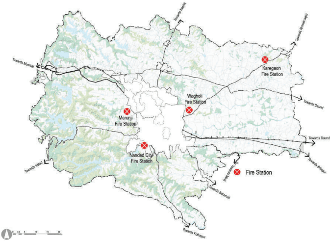
Fire services play a pivotal role in protecting people from fire hazards, road accidents, building collapse and other unforeseen emergencies. Fire is categorized as a disaster. PMR presently has three fire stations at Nanded City (Nanded Gaon), Marunji and Wagholi.
Table 6.5Fire Station - ELU/GIS Database
No
Taluka
Fire Station
1
Bhor
0
2
Daund
0
3
Haveli
2
4
Khed
0
5
Mawal
0
6
Mulshi
1
7
Purandar
0
8
Shirur
0
9
Velhe
0
Total
3
Source: GIS Database; Survey Data, ELU Database; Fire Department, PMRDA.
Figure 6.8: Fire Station with Buffer
Source: GIS Database; Survey Data, ELU Database; Fire Department, PMRDA.
Data in Table 6.5 indicates that Daund, Haveli, Khed and Shirur taluka lack fire services to serve their population adequately. At present, their requirements are being catered by closest urban local bodies with the provision of fire services. Therefore, it is imperative to develop the fire services infrastructure necessary to cater to the demands of the PMR population.
6.6Cremation Ground and Burial Ground
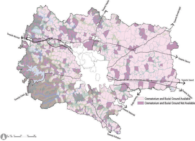
In PMR, there are a total of 103 Cremation grounds and 306 Burial grounds. Taluka wise distribution of cremation ground and burial ground in PMR is given in Table 6.7. It can be observed that there is no cremation ground in Purandar taluka and no burial ground in Mulshi taluka.
Chapter 6: Social Infrastructure
Figure 6.9: Availability of Crematorium and Burial Ground - ELU/GIS Database
Source: GIS Database; Survey Data, ELU Database;
Table 6.6 data indicates that PMR lacks in the provision of a burial ground in every taluka. Also, it has an insufficient number of cremation grounds in Daund, Haveli, Purandar, Shirur and Velhe talukas. To cater to present and future population needs, it is required to propose a larger cremation ground or a burial ground for a cluster of villages that would be easily accessible to the population.
Table 6.6Requirement of Cremation Ground and Burial Ground for Present Population