Topographically, PMR has the following four major physiographic units:
-
The Hills and Ghats: Strip of Sahyadri mountains towards the west is known as ‘Ghatmatha’ (1,420 m above MSL). This physiographic area has famous tourist places such as Lonavala and Khandala. The altitude of this area ranges between 500 m and 1500 m above MSL.
-
The Foothills: Undulating belt of 15-30 km towards the east of ‘Ghatmatha’ is called ‘Mawal’. The central parts of Mawal, Mulshi and Velhe talukas come under this region. The altitude of this region ranges between 100 m to 500 m above MSL.
-
The Central Plateau: The plain’s remaining belt on the east of ‘Mawal’ is called ‘Desh’. This area covers basins of the river Bhima and its tributaries. The central and western part of Khed taluka, the eastern zone of Velhe, Mulshi, Bhor talukas and western part of Haveli taluka falls in this area.
-
The Eastern Plains: The area of Shirur and Daund talukas is mostly plains.
Foothills of the Western Ghats are critical physical features of the region since they hold the majority of surface water resources. Water from these sources is stored in several small and large dams, pouring into irrigation systems and water supply systems. Pune and Pimpri-Chinchwad cities are settled on the central plateau located in the region. This plateau keeps these settlements from flooding in monsoon. Eastern plains are fertile and most productive of agricultural areas in the region. These plains have formed from alluvial deposits of rivers in the Krishna basin. However, these areas are also prone to frequent flooding and inundation.
Elevation and Slope Analysis
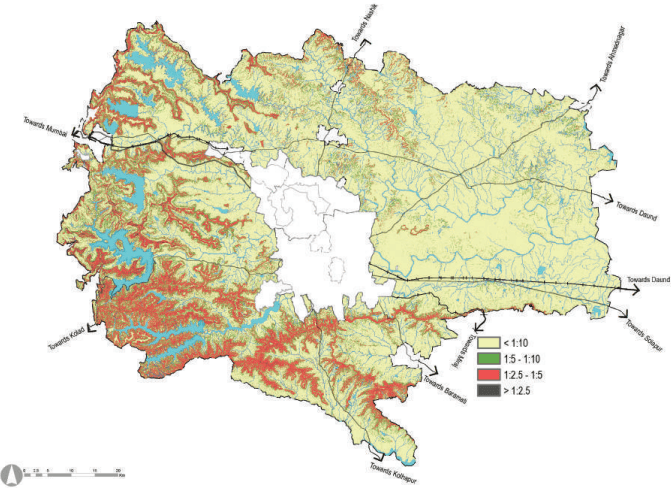
The region has an average elevation between 500m to 1400m from mean sea level. Based on the slopes, the Pune Metropolitan Region is divided into four categories.
| Sr No | Category | Slope gradient | Slope % | Area of PMR (sqkm) | Proportion (%) |
| 1 | Very Steep Slope | >1:2.5 | More than 40% | 46.81 | 0.76 |
| Very steep slopes occur in small parts of the Sahyadri Hills range, the ridge areas of Mulshi, Velhe talukas and a small narrow stretch in Bhor and Haveli talukas. | |||||
| 2 | Steep Slope | 1:2.5-1:5 | Less than 40% and more than 20% | 753.28 | 12.23 |
| A significant portion of hill ranges in Mulshi, Mawal and Khed talukas have steep slopes. | |||||
| 3 | Moderate Slope | S1:h5ir -u 1r,: K10hed a<sup>L</sup> thn<sup>e</sup>ad<sup>s</sup>n<sup>s</sup> P 1 <sup>t</sup>u<sup>h</sup>0r<sup>a</sup>a%<sup>n</sup>nd <sup>2</sup>a<sup>0</sup>r% ta alnudka mso hraeve7 m84a.j0o8r stretches of moderately1 s2lo.7p3ing. Small patches are also scattered in Haveli, Daund talukas and Pune city. |
|---|---|---|
| 4 | Gentle Slope | < 1:10 Less Than 10% 4573.29 74.25 Gentle sloping is scattered in all talukas of the district. This covers major areas of Daund, Shirur, Haveli talukas and Pune city. |
Source: GIS Data base
Figure 2.1: Slope Analysis
Source: GIS Data base