This chapter gives an overview of existing regional connectivity and movement of people and goods through three modes of transport - Road, Railway and Air. The chapter also presents a review of key transport proposals in the PMR Planning Area. It summarises analyses carried out to understand key issues and challenges of different transportation systems in place. This exercise is based on the data available with PMRDA and data shared by various government agencies, forming the basis for statistics in this chapter.
5.1 Background
Pune Metropolitan Region is located at a distance of 150 km to the southeast of Mumbai. PMR has been experiencing immense economic growth supported by favourable socio-economic conditions and investment climate. However, the economic sustainability of the region will require more efficient transport systems that will facilitate the movement of people and goods with a reduction in travel time and cost, leading to enhanced competitiveness of the region.
Since its inception in 2015, PMRDA has provided a significant thrust to infrastructure projects in the region with support from the state and central governments. List of such major transportation and urban development projects include Pune Ring Road, Metro/MRTS projects, greenfield airport and town planning schemes along the Pune Ring Road.
PMRDA commissioned Comprehensive Traffic and Transportation Study (CTTS) in 2017 to identify transport infrastructure requirements for the next 30 years in PMR necessary to meet the needs of the current and future population. This study aimed to prepare a long-term transport strategy for the region and identify a pragmatic capital investments program up to 2048 in line with the National Urban Transport Policy (NUTP) 2006. PMRDA appointed L&T Infrastructure Engineering Limited to carry out this study.
5.2Road Transport
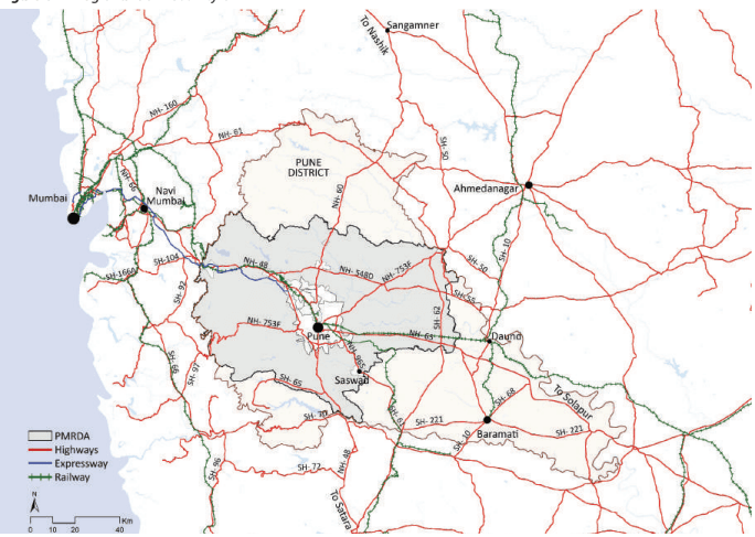
PMR is well connected to major cities by national highways, state highways and railways. Major national highways that pass through Pune include Mumbai-Bangalore (NH-48), Pune-Hyderabad (NH-65), Pune-Nashik (NH-60), Talegaon-Shikrapur (NH-548D) and Pune-Ahmednagar (NH-753F). Major state highways that pass through Pune provide good connectivity with major cities and ports.
Mumbai–Pune Expressway is India’s first six-lane concrete, high speed, access controlled tolled expressway. Operationalised in 2002, it provides a high-speed alternative to NH-48 between Mumbai and Pune while connecting important economic growth centres along its 95 km long alignment.
NH-48 traverses PMR from northwest to south. This highway connects the region with Mumbai and JNPT port on the northwest within 150 km. Further north, it then connects to Surat and Ahmedabad. Towards the south, NH-48 connects Pune to Satara and Kolhapur in Maharashtra and then further ahead with Bangalore and Chennai. Some of the important economic centres along the NH-48 are Hinjawadi IT Park, Talegaon and Lonavala.
o The Rajiv Gandhi InfoTech Park has transformed Hinjawadi into a major IT hub of the country.
o Talegaon is a growing urban centre with an adjoining MIDC industrial area.
Lonavala is a rominent to rist s ot that attracts a lar e n mber of to rists thro ho t the entire ear o Lonavala is a prominent tourist spot that attracts a large number of tourists throughout the entire year.
NH-60 passes through the north of PMR and connects Pune to Nashik. Major economic centres along the highway include Rajgurunagar, Chakan and Bhosari. All three are major industrial hubs developed by MIDC.
NH-753F traverses PMR from southwest to northeast. On the southwest, it connects Pune to Dighi port. On the north-eastern side, it connects PMR to Ahmednagar and onward to Aurangabad and then to Nagpur.
NH-65 is a major corridor along the eastern part of PMR connecting Pune to Solapur and onwards to Hyderabad. A bypass is provided for the road from Hadapsar to Katraj and meets NH-48 bypass at Katraj Chowk. Hadapsar is a major economic centre located along the highway. It is an industrial hub and has three
SEZs – Magarpatta, Amanora Park Town and SP InfoCity.
NH-965 connects Pune to Saswad, where the Chatrapati Sambhaji Raje International Airport is proposed.
To summarise, these highways connect PMR directly with Nashik, Aurangabad, Nagpur, Mumbai, Kolhapur, Solapur, Hyderabad and Bangalore.
Table 5.1Distances from Major Towns, Cities and Ports
No
Town/City/Port
Distance (km)
1
Satara
100
2
Ahmednagar
105
3
JNPT Port
140
4
Mumbai
163
5
Dighi Port
166
6
Nashik
202
7
Kolhapur
233
8
Solapur
243
9
Bangalore
835
10
Delhi
1,417
Source: Google Earth
Figure 5.1: Regional Connectivity of PMR
Source: Comprehensive Traffic and Transport Study, (CTTS) for PMR, Dec 2019
Chapter 5: Traffic and Transportation
Road Network
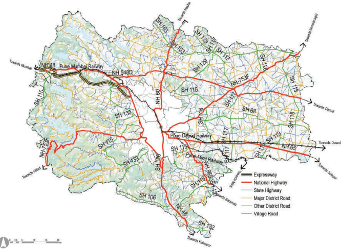
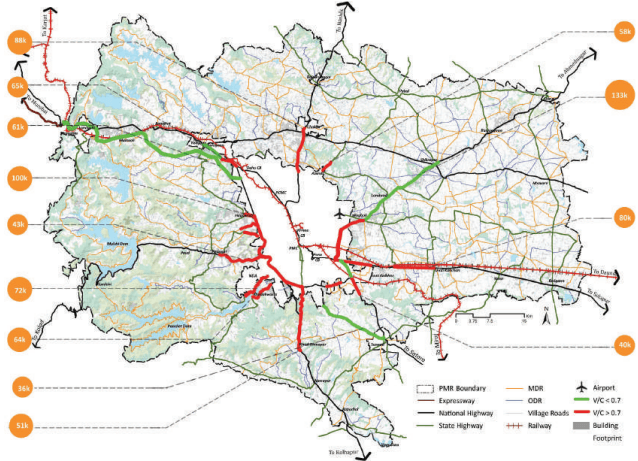
PMR has a dense road network of length 28,572 km comprising national highways, an expressway, state highways, major district roads, other district roads, village roads and internal roads. There are five national highways, one expressway and three major state highways in the region that form a radial network providing access to goods and passengers in and out of the region.
Figure 5.2: Existing Road Map
Source: Public Works Department GoM, Pune; Comprehensive Traffic and Transport Study, (CTTS) for PMR, Dec 2019
National highways connect the region with other states and cities and provide internal connectivity to municipalities and MIDCs in the region. State highways connect the region with other cities. Major district roads and other district roads provide taluka level connectivity, and the village roads and internal roads connect the villages. The share of these roads in the region is given in Table 5.2.
Table 5.2Length of Roads
No
Hierarchy of Roads
Length (km)
Percent (%)
1
Expressway
37.48
0.13
2
National Highway
346.16
1.23
3
State Highway
570.67
2.03
4
Major District Road
1,520.25
5.41
5
Other District Road
628.24
2.23
6
Village Road
1,488.82
5.30
7
Internal Road
23,489.78
83.64
8
Total
28,081.40
100
Source: GIS Database
Regional Plan (1997) Roads
PMRDA has taken Regional Plan 1997 as the base for the planning. Much of the development in PMR, as well as building permission sanctions, occurred considering RP proposals. Subsequently, the road network from the RP 1997 has formed the basis for road proposals in this Development Plan.
Although RP 1997 proposed a robust road network to supplement existing roads in PMR, only 60% of these proposed roads have materialised thus far. Many roads were converted into classified roads, and the planning authorities revised some roads from RP 1997 falling in their jurisdictions.
Regional Plan also included Pune Ring Road, which is currently taken on priority by PMRDA. The Regional Plan also proposed alternative routes to highways passing through major towns such as Chakan, Wagholi, Hinjawadi, Shikrapur, Khed Shivapur, Loni Kalbhor and Uruli Kanchan. In addition to these bypasses, the Regional Plan also proposed roads to enhance connectivity between municipal councils and corporations.
Table 5.3RP 1997 Road Length
Category
Length (km)
Total Length of RP roads in PMR
1,462.18
Total Length of Developed RP roads
901.04
Total Length of RP roads yet to be developed
561.14
Source: GIS Database
Existing Traffic on roads
Pune and Pimpri Chinchwad cities have witnessed a drastic surge in private vehicular traffic over the past three decades. The PMR is also witnessing a similar trend as spillover growth from these two cities is absorbed into PMR. With the development of IT parks and auto industries in peripheries of municipal corporations, to and fro commute from the corporations to these peripheral areas has increased rapidly, resulting in excessive traffic on major arterial corridors, including national highways. Classified traffic volume counts that were conducted as part of the CTTS are presented below.
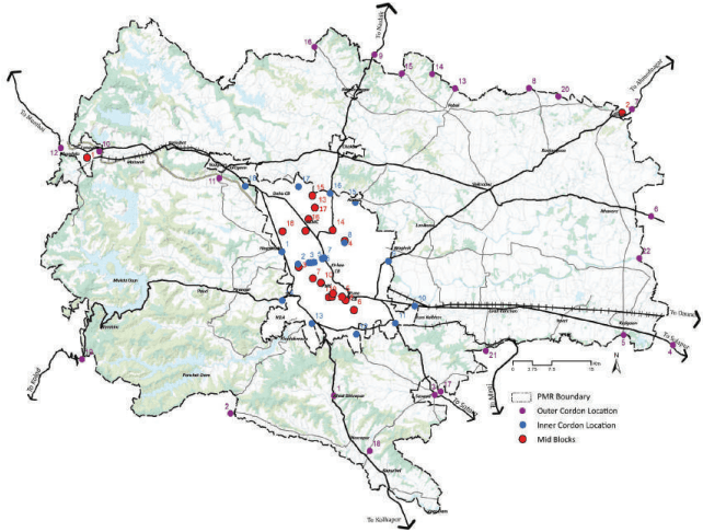
Traffic volume count survey at outer and inner cordon locations:
Based on the analysis, about 28.64 lakh vehicles (26.59 lakh PCU) travel north-south and 13.71 lakh vehicles (12.70 lakh PCU) travel east-west every day.
Outer Cordon
a. About 3.4 lakh vehicles enter and leave PMR daily.
b. The highest traffic volume was observed on Satara Road (Khed Shivapur toll plaza), i.e. 56,750 vehicles, followed by Pune-Mumbai Expressway Talegaon toll plaza (46,200 vehicles).
c. With a share of 39.2%, cars dominated the traffic composition at outer cordons in PMR, followed by twowheelers (36.1%) and goods vehicles (19.6%).
d. Peak hour traffic, as a percentage of total daily traffic, stood between 5.6% and 9.9%, with an average of 7.7%.
Issues and Challenges
Based on the analyses conducted as part of the CTTS, key issues and challenges of the existing road transportation systems in PMR are as follows:
Chapter 5: Traffic and Transportation
• Inadequate carrying capacity of radial growth corridors, national highways and major state highways
• Absence of Ring Roads, bypass roads, alternative roads to radial roads
Congested up entry/exit points to PMC and PCMC due to non-segregated external traffic
• Low quality of roads in terms of available road widths and pavement condition
Weak accessibility to the Western Ghats and tourism nodes
Lack of connectivity to villages
• Absence of implementation strategy for Regional Plan roads beyond municipal corporation limits in PMR
5.3Rail Transport
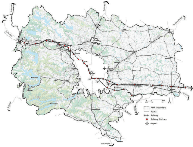
PMR is well connected to major cities of the country through an extensive regional rail network. This railway network is under Central Railways jurisdiction, consisting of broad gauge lines both electrified and non-electrified.
The two major railway routes in the region are Mumbai-Pune-Solapur and Pune-Miraj. Daund is a major junction located outside the Study Area, and it is connected with Baramati and Ahmednagar.
Figure 5.7: Existing Railway Network in PMR
Source: Central Railway, Pune Division; Comprehensive Traffic and Transport Study, (CTTS) for PMR, Dec 2019
Table 5.6 Contains rail ridership statistics, including suburban passengers.
Suburban railways alone carry 1.1 lakh (2017) passengers every day. The highest ridership was observed on the Pune-Lonavala section, with a total number of 68,899 (2017) passengers boarding and alighting per day on 18 trains. Trains on this route run with a minimum frequency of 30 minutes. Another route with a significant number of passengers is the Pune-Daund line, with eight services per day. The average trip length of passengers on suburban rail stands at 41 km in PMC and 15 km in the PCMC area.
Table 5.6Characteristics of Existing Railway Lines in PMR
Route
Length (km)
Specification
Annual Ridership (million)
Capacity
Pune-Lonavala
63
Double line
28.6
142
Pune-Daund
64
Double line
NA
107
Pune-Miraj
32
Single line
14.5
118
Source: Central Railway, Pune Division.
Ridership on the Pune-Mumbai route is rising rapidly due to residential and industrial developments along this corridor. All the railway lines are operating beyond their capacity. Lands around railway stations at Yavat, Kedgaon, Kutbav, Kadetan and Malavali are not utilised to their potential. One of the reasons is the absence of robust road connectivity between railway stations and the highway network. The existing Inland Container Depot (ICD) is at Chakan MIDC Phase 2. The facility is spread over 12.5 acres with an annual capacity of 60,000 TEUs. It serves logistic demand between Nashik, Pune and JNPT port. The facility lacks railway connectivity to ensure the economical and sustainable movement of goods.
Key issues and challenges
Based on the analyses conducted as part of the CTTS, key issues and challenges of the existing rail network in PMR are as follows:
• Existing railway lines are being utilised beyond their capacity hampering the suburban rail frequency.
Bypass Railway line that will connect all three existing railway lines, act as suburban ring railway serving goods transport. Pune Railway Division presented this requirement to PMRDA. PMRDA has incorporated the same in the Comprehensive Mobility Plan 2018.
• Road network connectivity to railway stations, particularly in rural areas of the region, is weak.
• Lower frequency of suburban rail services leading to a dependency on the road-based transport system.
• Linkages with major industrial nodes for passenger and goods movement are inadequate.
The capacity of the single and non-electric Pune-Miraj railway line is limited.
Rail connectivity to industrial areas in the Pune region is weak.
5.4Public Transport and NMT
Public Transport
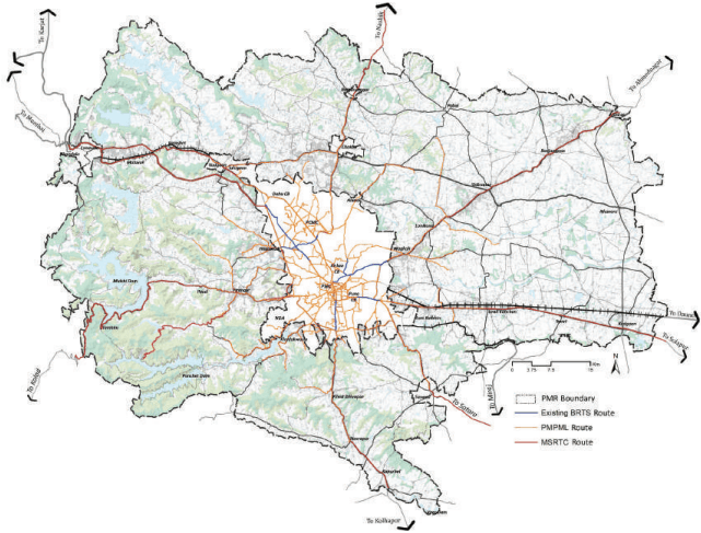
Public Transport in PMR consists of bus and rail-based nodes of transport for mobility. The city bus service provided by PMPML serves the city centre and suburbs up to 20 km from PMC and PCMC boundaries. MSRTC provides intercity bus services for passengers travelling outside Pune.
Public transport coverage is primarily concentrated in PMC and PCMC jurisdictions. In the rest of PMR, public transport coverage is limited to only national highways and some major roads. Lack of demand for buses due to high dependency on private vehicles, company buses for daily commute to and fro between home and office adds to conjestion. Thus, to improve the public transport coverage in the rest of PMR, the major focus needs to be on developing residential and employment centres around the rail and road-based infrastructure provisions.
Chapter 5: Traffic and Transportation
Figure 5.8: Public Transport Coverage in PMR
Source: Central Railway, Pune Division; Comprehensive Traffic and Transport Study, (CTTS) for PMR, Dec 2019; Public Works Department GoM, Pune;
Private and state-run intercity bus services to major cities in the state and neighbouring states currently serve PMR. Maharashtra State Road Transport (MSRTC) operates the state-run bus service with a fleet of over 18,000 buses. These buses run from four bus terminals: Swargate, Shivaji Nagar, Pune Railway Station and Vallabh Nagar. From the latest statistics, an average of 0.3 million passengers travelled on MSRTC services.
PMPML operates the city bus service serving the city centre and suburbs, up to 20 km from PMC and PCMC, with a fleet size of 1,500 operating on 371 routes. This bus service provides public transport connections from PMC and PCMC to the major MIDC centres and municipal councils. The annual ridership for PMPML services has declined from around 420 million passengers in 2013 to about 390 million passengers in 2016. The decreased ridership can be attributed to the shift to private vehicles. Long-distance PMPML bus routes operate at lower than 2-hour frequency due to less ridership.
Non-Motorized Transport (NMT)
There is limited data on non-motorised transport infrastructure in PMR. Based on CMP and CTTS data, the current share of trips by walking is about 33% with an average trip length of about 0.9 km. It is observed that the NMT infrastructure in PMR is poor, with no footpaths on most roads, encroachments on existing footpaths or used as parking spaces by vehicles. There is also a lack of cycling infrastructure, with the total length of cycle tracks only about 64 km. Consequently, the mode share of cycling is meagre, accounting for only 2.7% of all trips, with an average trip length of 3.28 km.
5.5Freight Transport
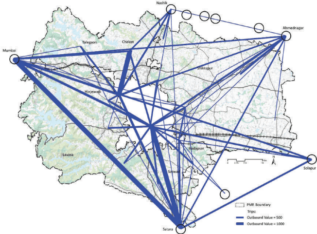
The need for the movement of goods is linked with the land uses spread across the region. PMR is established as an automobile manufacturing hub with industrial and warehouses spread across the region along major transport corridors. These uses demand mobility of raw materials and finished goods in and outside the region. Nashik Road, Nagar Road, Saswad Road, Solapur Road and Mumbai-Pune Expressway are observed to have higher volumes of freight travelling on them than other roads. In terms of percentage share of traffic, the highest share is seen on Nashik Road and Solapur Road due to the rail siding facility near Fursungi. All national highways are identified as major freight corridors for PMR. The movement of heavy vehicles within the municipal limits during the daytime is restricted to avoid their impact on local traffic.
Table 5.7Goods vehicles on radial roads in PMR
Location
Goods vehicles
Share (%)
Mumbai-Pune Expressway
9,066
8.03%
Saswad-Jejuri Road
3,482
3.08%
Moshi Toll Plaza, Nashik Road
13,810
12.23%
Near Sambhaji Chowk, Alandi Road, Alandi
5,365
4.75%
Nagar Road
10,484
9.28%
Kawadipeth Toll Plaza, Solapur Road
12,851
11.38%
Saswad Road
7,007
6.20%
Saswad-Bopdev Road
2,836
2.51%
Sinhgad Road
3,615
3.20%
NDA Academy Road
2,904
2.57%
Near Bhugaon, Mulshi Road
3,277
2.90%
Shivaji Chowk, Hinjawadi
3,376
2.99%
Dehu Road Toll Plaza, Mumbai-Pune Highway
9,781
8.66%
Talwade, Dehu Alandi Road
12,279
10.87%
Katraj-Satara Road
5,211
4.61%
5.6Air Transport
PMR has an international airport located at Lohegaon within municipal corporation limits. This airport is also an airfield station of the Indian Air Force. The airport accommodates passenger and goods movement of both domestic and international flights. The other international airport in the proximity of PMR is the Mumbai airport, with more robust connectivity to international destinations.
Pune airport has a runway length of 2,539 m that can handle all medium-range and few long-range aircraft. The airport currently handles 8.16 million passengers and 41,566 tonnes of cargo annually. The passengers handled at the airport are growing at an average CAGR of 19% in the past three years. Moreover, the airport shares runway and Air Traffic Control (ATC) facilities with the Air Force base leading to restrictions on operations of civil flights.
Considering all these factors and limitations on expanding the existing airport, to meet the growing demand, the Government of Maharashtra has proposed developing a new greenfield airport in Purandar taluka. It would be approximately 38 km from Pune city. MADC is appointed as the nodal agency and “Special Planning Authority” to develop the new airport.
5.7Metro Transport
Currently, the Metro rail system is under implementation on three corridors in PMC and PCMC with a total route length of 54 km. The corridors are a combination of both elevated and underground sections.
Line-1: PCMC to Swargate (16.58 km with 14 stations)
Line-2 Vanaz to Ramwadi (14.66 km with 16 stations)
Line-3: Hinjawadi to Shivaji Nagar (23 km with 23 stations)
MahaMetro, an SPV between the Government of India and the Government of Maharashtra, is executing the first two lines. PMRDA is executing the third line under the public-private partnership model and has awarded the project to the consortium of TUTPL and Siemens. The metro corridors are expected to be operational in a phasewise manner.
Inner Cordon
a. About 11.28 lakh vehicles enter and leave PMC and PCMC daily.
b. The highest traffic volume was observed at Shivaji Chowk (Hinjawadi), i.e. 1,69,000 vehicles, followed by Ahmednagar Road (1,57,916 vehicles).
c. Two-wheelers, with a share of 57.7%, dominated the traffic composition, followed by cars (26.3%) and goods vehicles (9.1%).
d. Peak hour traffic, as a percentage of the total daily traffic, stood between 6.6% and 9.5% with an average of 7.0%.
Figure 5.3 and Table 5.4 presents the location wise traffic volume.
Chapter 5: Traffic and Transportation
Figure 5.3: Outer and Inner Cordon Survey Locations
Source: Comprehensive Traffic and Transport Study, (CTTS) for PMR, Dec 2019
Table 5.4Traffic volume count observed at major roads on outer cordon
No
Road/Location
Vehicles
PCU
Share (%)
1
Khed Shivapur Toll Plaza, Satara Road (L1)
56,750
65,298
16.10%
2
Velhe Bk Village Road (L2)
2,145
1,969
0.49%
3
Saswad Jejuri Road and Indraprastha Road Junction (L3)
Source: Comprehensive Traffic and Transport Study, (CTTS) for PMR, Dec 2019
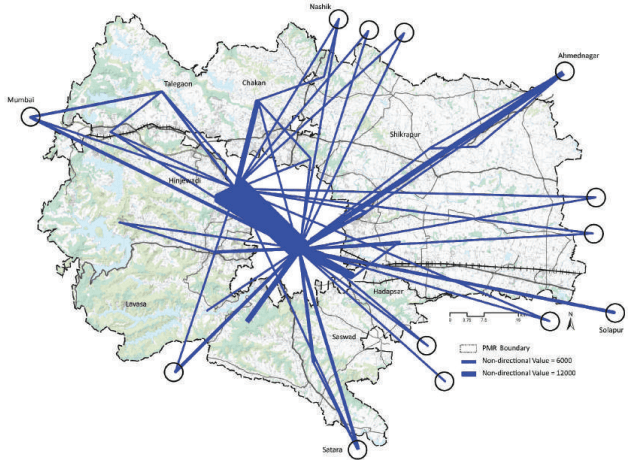
Figure 5.5: CTTS: Movement Pattern in PMR
Source: Comprehensive Traffic and Transport Study, (CTTS) for PMR, Dec 2019
Figure 5.5 shows trip movements in PMR. It can be seen that most trips start and terminate in municipal corporation areas. Thus, to influence the land use and have a uniform distribution of trips, it is essential to have a ring road around Pune and Pimpri Chinchwad cities.
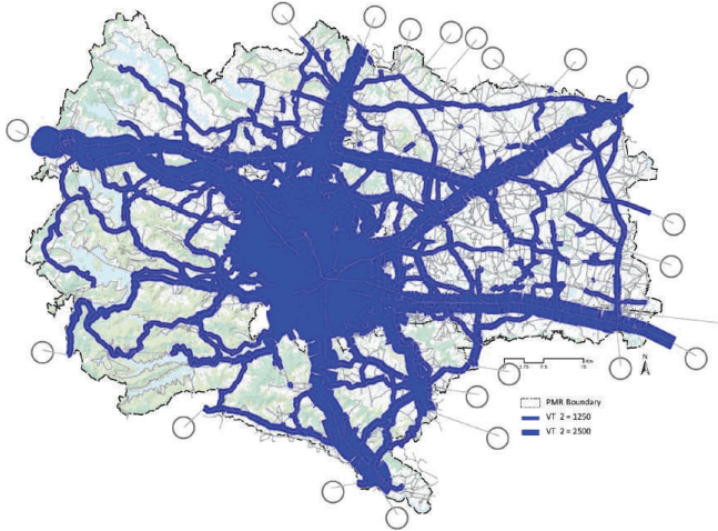
Figure 5.6: CTTS: Private Vehicle flow along major corridors for PMR (2018)
Source: Comprehensive Traffic and Transport Study, (CTTS) for PMR, Dec 2019
Figure 5.6 indicates traffic on existing roads. Roads with traffic more than 1,250 PCUs/hour on minor roads and 2,500 PCUs/hour on major roads are selected. The thickness of the line denotes the intensity of traffic. The thicker the line, the heavier is the traffic. It can be inferred that there is heavy radial road dependency for reaching municipal corporation areas.
Road network inventory for PMR was prepared as part of the CTTS. Single lane roads constitute around 57% of the total road length in the Study Area, followed by intermediate lane roads at about 22%. In Study Area, roads without footpath are much more in numbers vis-a-vis roads with a footpath.
Household Surveys
About 62% of households in the Study Area own a two-wheeler, 10% of households own a car and twowheeler, about 3% of households own a cycle only and 13% own no vehicles.
The per capita trip rate in PMR, including walking and cycling, is 1.26 whereas for motorized trips only it is 0.79. The highest average motorized trip rate was observed in PMC, i.e. 0.90, followed by PCMC, i.e. 0.82.
The mode-wise distribution of trips (including walking and cycling) in PMR is dominated by walking, i.e. 35.1%, followed by two-wheelers (33.2%) and buses (9.9%). The share of trips catered to by cars is at 9.1%.
Work-based activities dominate the distribution of trips based on purpose in PMR, i.e. 51.3%, followed by educational trips (33.8%). The average per capita trip length in PMR, including walking and cycling, is 5.16 km. In contrast, for motorized only trips, it is 7.80 km. The highest average motorized trip length was observed in the rest of PMR, i.e. 9.43 km.
Key issues and challenges
Based on the analyses conducted as part of the CTTS, key issues and challenges of the existing public transportation systems and NMT in PMR are as follows:
• Absence of suburban rail-based public transport causing high dependency on road-based transport
• Limited public transport coverage in PMR, resulting in fewer shares of public transport trips
• A low frequency of bus services in the region due to less ridership
Inadequate NMT facilities and their integration with transport nodes
Sus Road
1,758
1.56%
Nande-Balewadi Road (Mahalunge)
1,068
0.95%
Manjari Village, Manjari Road
2,742
2.43%
Lohegaon-Nirgudi Road
215
0.19%
Lohegaon-Wagholi Road
1,836
1.63%
Total
1,12,963
100
Source: Comprehensive Traffic and Transport Study, (CTTS) for PMR, Dec 2019;
Chapter 5: Traffic and Transportation
Figure 5.9: Desired line diagram showing the Goods vehicle movement in PMR
Source: Comprehensive Traffic and Transport Study, (CTTS) for PMR, Dec 2019;
Goods movement in PMR is also catered to by the rail systems. Railway sidings are present in various locations of PMR. As rail sidings are restricted along the existing rail lines, a new bypass line will touch other industrial areas like Chakan, Shikrapur on Nashik Road and Nagar Road. The proposed Ring Roads are necessary to provide relief to goods traffic as there is heavy external-to-external truck traffic, as seen in Table 5.7.
Key Issues
Based on the analyses conducted as part of the CTTS, key issues and challenges of the existing freight transportation systems in PMR are as follows:
• Lack of truck terminals in PMR; rail siding and truck parking facilities are located within PMC and PCMC areas.
Freight vehicles travel through the congested city road network even though their destinations are not within the city. Bypass rail for goods is needed.
Infrastructure is inadequate to accommodate freight vehicles on radial roads.
• Inadequate cargo parking facilities in industrial areas have led to inefficient carriageway utilisation.