This chapter covers an assessment of the region’s environmental features, including the topography, geology, climatology, and status of natural resources such as water, forests, agriculture, and the pollution levels observed in the region.
Approximately 38% of the PMR area is currently used for agricultural purposes, and most of the urbanisation is envisaged to add to the urban agglomeration of Pune and Pimpri-Chinchwad cities. Rapid urbanisation has been exerting tremendous pressure on environmental resources in the region.The Planning Area population is estimated to grow almost three times to over 54 lakh by the year 2041. Thus, resources must be equitably allocated amongst entities mandated with regulation and management of resources in the region.
2.2Geology
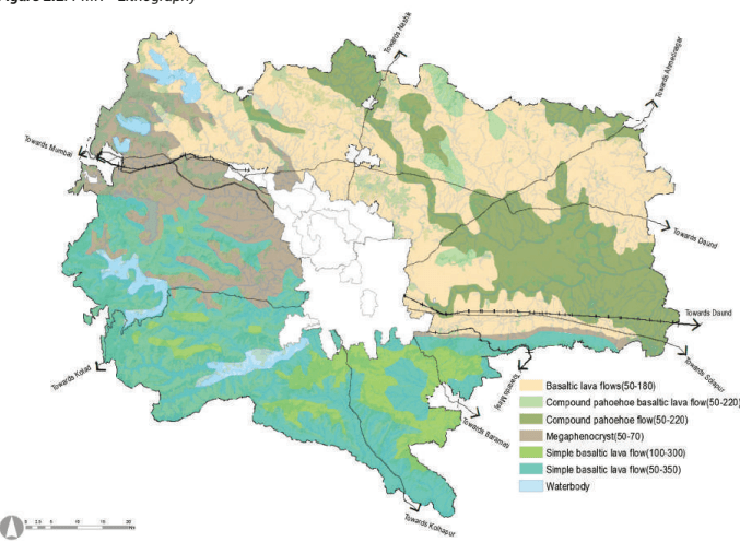
Almost all the rocks in PMR are varieties of Deccan trap-basalts. The outpouring of enormous lava spread over vast areas in western and central India led to their formation. The lavas are called ‘Plateau basalts’ because of their dominantly basaltic composition and as they tend to form flat-topped plateau-like features. Such flows are called ‘traps’ because of their step-like or terraced appearance. The rock is dark grey to greenish-grey in colour.
The district’s basaltic dykes are all upright and do not seem to have caused disturbance or dislocation in basalt strata. Two dykes about 4 feet wide run obliquely across the Indrayani valley, 55 km north-west of Pune, and intersect each other. Small dykes are seen near Pune Cantonment and at the southern slopes of the hills near Bhosari and Dighi. These dykes are to be regarded as feeders for the trap flows and are expected to be present underneath the traps’ main mass. In general, they show regularity in direction, thickness and size. The details of rocks and minerals of PMR are represented in Figure 2.2.
Chapter 2: Physical Features and Environment
Figure 2.2: PMR - Lithography
Source: Geological Survey of India
2.1Topography
Topographically, PMR has the following four major physiographic units:
The Hills and Ghats: Strip of Sahyadri mountains towards the west is known as ‘Ghatmatha’ (1,420 m above MSL). This physiographic area has famous tourist places such as Lonavala and Khandala. The altitude of this area ranges between 500 m and 1500 m above MSL.
The Foothills: Undulating belt of 15-30 km towards the east of ‘Ghatmatha’ is called ‘Mawal’. The central parts of Mawal, Mulshi and Velhe talukas come under this region. The altitude of this region ranges between 100 m to 500 m above MSL.
The Central Plateau: The plain’s remaining belt on the east of ‘Mawal’ is called ‘Desh’. This area covers basins of the river Bhima and its tributaries. The central and western part of Khed taluka, the eastern zone of Velhe, Mulshi, Bhor talukas and western part of Haveli taluka falls in this area.
The Eastern Plains: The area of Shirur and Daund talukas is mostly plains.
Foothills of the Western Ghats are critical physical features of the region since they hold the majority of surface water resources. Water from these sources is stored in several small and large dams, pouring into irrigation systems and water supply systems. Pune and Pimpri-Chinchwad cities are settled on the central plateau located in the region. This plateau keeps these settlements from flooding in monsoon. Eastern plains are fertile and most productive of agricultural areas in the region. These plains have formed from alluvial deposits of rivers in the Krishna basin. However, these areas are also prone to frequent flooding and inundation.
Elevation and Slope Analysis
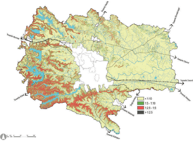
The region has an average elevation between 500m to 1400m from mean sea level. Based on the slopes, the Pune Metropolitan Region is divided into four categories.
Table 2.1Slope Analysis for Study Area
Sr No
Category
Slope gradient
Slope %
Area of PMR (sqkm)
Proportion (%)
1
Very Steep Slope
>1:2.5
More than 40%
46.81
0.76
Very steep slopes occur in small parts of the Sahyadri Hills range, the ridge areas of Mulshi, Velhe talukas and a small narrow stretch in Bhor and Haveli talukas.
2
Steep Slope
1:2.5-1:5
Less than 40% and more than 20%
753.28
12.23
A significant portion of hill ranges in Mulshi, Mawal and Khed talukas have steep slopes.
3
Moderate Slope
S1:h5ir -u 1r,: K10hed a<sup>L</sup> thn<sup>e</sup>ad<sup>s</sup>n<sup>s</sup> P 1 <sup>t</sup>u<sup>h</sup>0r<sup>a</sup>a%<sup>n</sup>nd <sup>2</sup>a<sup>0</sup>r% ta alnudka mso hraeve7 m84a.j0o8r stretches of moderately1 s2lo.7p3ing. Small patches are also scattered in Haveli, Daund talukas and Pune city.
4
Gentle Slope
< 1:10 Less Than 10% 4573.29 74.25 Gentle sloping is scattered in all talukas of the district. This covers major areas of Daund, Shirur, Haveli talukas and Pune city.
Source: GIS Data base
Figure 2.1: Slope Analysis
Source: GIS Data base
2.3Soil Type
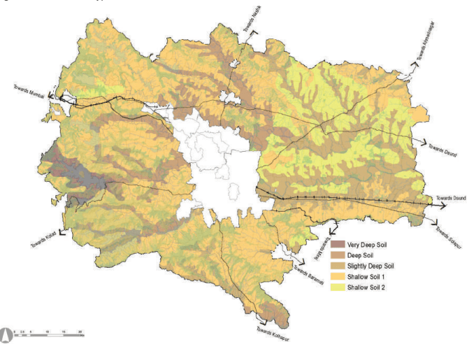
Soils in PMR are classified into broad five types based on soil depth, drain, soil characteristics and slope. Table 2.2 and Figure 2.3 show the soil types and their locations in PMR.
Table 2.2Soil types within Pune district
Type
Soil Type Very deep, well-drained, loamy soils on gently sloping narrow valleys with moderate erosion.
Locations in PMR
1: Very Deep Soil
Patches are spread in Mulshi, and some parts of Velhe taluka.
2: Deep Soil
Deep, moderately well-drained, strongly calcareous, fine soils on gently sloping plains and valleys with moderate erosion.
Narrow stretches are spread in Khed, Mawal, Mulshi, Velhe, Haveli, Bhor and Purandar talukas along river banks.
3: Slightly Deep Soil
Slightly deep, well-drained, fine, calcareous soils on very gently sloping lands with mesas and buttes with moderate erosion.
Major portions of Purandar, Pune City, Haveli, Daund and Shirur talukas have this soil coverage.
4: Shallow Soil - 1
Shallow well-drained, clayey soils on gently sloping lands with mesas and buttes with moderate erosion and slight stoniness.
Major portion of the region is covered by this type of soil. This includes the major portion of Mawal, Khed, Mulshi, Velhe, Bhor, Purandar Haveli and Daund talukas. Small stretches are spread in Pune City and Shirur talukas.
5: Shallow Soil - 2
Shallow, well-drained, clayey soils on gently sloping land with moderate erosion.
Stretches are spread in Mawal, Shirur, Haveli, Purandar and Daund.
Source: District Environment Atlas for Pune District By MPCB 2006; DIstrict Agricultural Depatment, Pune (www.mpcb.gov.in); NBSS-National Bureau of Soil Survey, Zoning Atlas Division.
Figure 2.3: PMR - Soil Types
Source: District Environment Atlas for Pune District By MPCB 2006; DIstrict Agricultural Depatment, Pune (www.mpcb.gov.in); NBSS-National Bureau of Soil Survey, Zoning Atlas Division.
2.4Climatology
The climate of PMR is studied at Pune district level. Pune district is part of the tropical monsoon land and therefore shows a significant seasonal variation in temperature and rainfall conditions. The climate of the western region of Pune district is cool, whereas the eastern part is hot and dry.
Rainfall
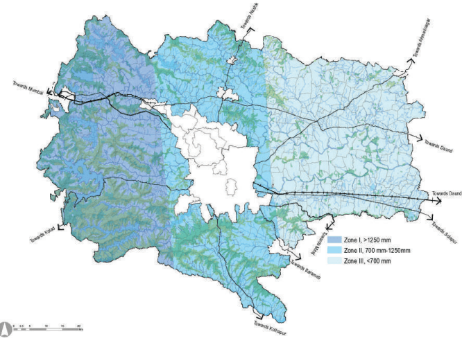
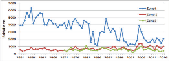
Pune Metropolitan Region has a varied topography and physiography. Likewise, the climate varies drastically ranging from high rainfall areas to the areas having low rainfall. Based on climatic characteristics, PMR is divided into three zones.
Zone-1 (High Rainfall Zone): This zone includes narrow strips extending from north to south along the crest of Sahyadri ranges. It consists of hilly high lying terrains and part of Mawal, Mulshi and Velhe talukas where rainfall is above 1250 mm.
Zone-2 (Medium Rainfall Zone): This zone includes the central part of PMR where rainfall ranges from 1250mm to 700mm. It includes part of Khed, Pune City, Bhor, Haveli and Purandar talukas.
Zone-3 (Low Rainfall Zone): This zone includes talukas with the lowest rainfall intensity. The decline in rainfall amount towards the east is due to the Sahyadrian mountainous zone, which creates a rain shadow region, where rainfall is below 700mm. It includes parts of Shirur, Haveli and Daund talukas.
The western part of the region adjacent to the west coast is a hilly area with forest cover, due to which the rainfall intensity is very high in this part compared to the eastern parts. Zone wise yearly total Rainfall data during years 1951-2016 is shown in Figure 2.5.
Figure 2.5: Zone wise yearly total rainfall data during the years 1951-2016
Chart C2. 4 Zonewise Total Rainfall- PuneMetropolitan Region (1951-2016)
Source: Indian Metorological Department, Ministry of Earth Science.
Temperature and Humidity
April and May are the hottest months in the district. The maximum temperature during these months often rises above 36° C. The western and northern regions i.e. Khed, Mawal, Mulshi and Velhe talukas, are cool, whereas the eastern part, i.e. Shirur, Daund talukas, is hot and dry. In the summer months, the relative humidity ranges from a minimum of 20% to a maximum of 67% during the day. During the monsoon period, the relative humidity varies from 68% to 87%. The relative humidity during winter shows maximum daytime variation, ranging from 37% to 88%.
Wind
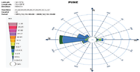
Twelve-hour observations of wind direction and speed over twelve months reveal that westward winds are observed for over 57% of the times in a year with speeds ranging between 1.5-4.5 m/s. The predominant winds from the west and south-west direction are responsible for the monsoons as they carry moisture-laden clouds from the Arabian sea. Potential for wind energy lies in the western and southern parts of the region. In monsoon, the Western Ghats prevent strong winds from blowing into the region from the west and carrying away moisture. Wind frequency is more during the monsoon season, with the percentage of frequency reaching as high as 73% with not much variation during the daytime.
Figure 2.6: Wind Rose
Source: Indian Metorological Department, Ministry of Earth Science
2.6Environmental Status
As PMR develops, there would be growth in population, industries and ancillary facilities with potential stress on the environment. The environment is a crucial factor that needs to be considered when framing land uses and built form for this growth. Furthermore, it should be seen that environmental pollution like air and water pollution does not cross the maximum permissible range.
Air Quality
Air quality is an essential component of everyday life. The Central Pollution Control Board (CPCB) has set National Ambient Air Quality standards applicable nationwide. CPCB has been conferred this power by the Air (Prevention and Control of Pollution) Act 1981. Air Quality Index (AQI) is a tool to showcase air quality status. As the AQI increases, an increasingly large percentage of the population is likely to experience adverse health effects. Major air pollution sources are industrial estates and vehicles from traffic within the town along highways and unpaved roads. The air pollution from industrial estates belongs to A1 and A2 categories having potential air pollution impact areas ranging from 7-15 km and 5-7 km respectively. Based on the field survey, the air quality in Pune district is relatively free of pollutants. However, the RSPM level is on the higher side in a few areas of Pune city.
Water Quality
Maharashtra Pollution Control Board (MPCB) is executing the GEMS (Global Environmental Monitoring System) and MINARS (Monitoring of Indian National Aquatic Resources) projects under National Water Quality Monitoring Program (NWMP) funded by CPCB to understand the nature and extent of pollution control required in the state. At present MPCB monitors 48 surface water and 25 groundwater locations in Maharashtra. Monitoring at these stations is done as per the uniform protocol for water quality monitoring prescribed by MoEFCC and CPCB. There are 21 water quality monitoring stations present within Pune Metropolitan Region. Parameters which are observed are PH, BOD, COD, Nitrate and Fecal Coliform. Table 2.4 gives representative data of water qualities of the Indrayani River at major stations.
Table 2.4Surface Water Quality of Indrayani River, Pune 2016 (MPCB)
Months
pH
Dissolved Oxy-gen (mg/l)
B.O.D.(mg/l)
C.O.D.(mg/l)
Nitrate(mg/l)
Fecal Coliform (MPN/100 ml)
Standard Parametres
6.5-8.5
Min. 4 mg/l
100
250
Max. 20
Max. 500
January
7.6
6.27
4.8
13.2
2.51
N/A
February
8.2
Nill
10.6
28.4
0.6
N/A
March
8
3.09
4.2
16
N/A
N/A
April
7.8
4.8
5.2
16
0.5
20
May
7
2.6
12.5
40
0.3
20
June
7.7
5.9
3.8
16
0.2
25
July
7.1
5.5
6.2
20
0.6
25
August
N/A
N/A
N/A
N/A
N/A
N/A
September
8.4
6
3.6
12
0.3
N/A
October
7.7
6.1
2.8
8
0.4
N/A
November
N/A
N/A
N/A
N/A
N/A
N/A
December
N/A
N/A
N/A
N/A
N/A
N/A
Note: B.O.D. – Biological Oxygen Demand; C.O.D. – Chemical Oxygen Demand; M.P.N. – Most Probable Number
Source: Maharashtra Pollution Control Board (MPCB).
2.5Hydrology
River Systems of PMR
All rivers in PMR mostly originate from the western part of the Sahyadri Hills and flow through the eastern part of the district.
The Pune Metropolitan Region has three major river systems, namely:
The Bhima-Ghod River system in the northern, north-eastern and eastern part
Mula-Mutha River system covering the central part
Small part of the Nira River system covering the south part
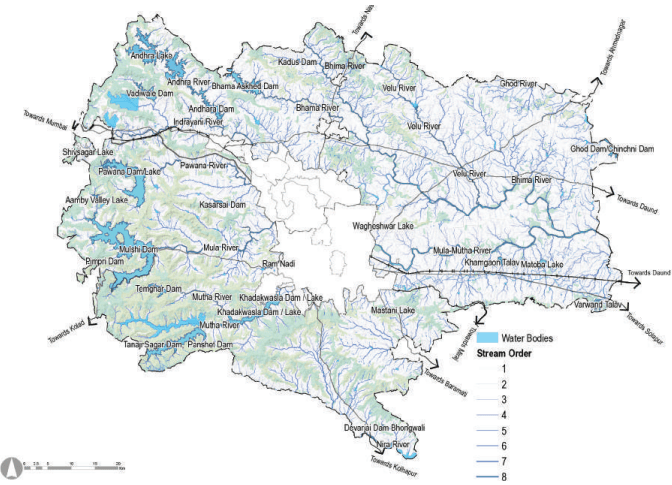
Major rivers originating in the region include Bhima, Bhama, Pavana, Indrayani, Mula, Mutha and Nira, all tributaries of Bhima. These rivers originate in the Sahyadri region on the western side and have minimum travel length. Most of the reservoirs are located on the western side of the region wherein the annual rainfall is both higher and assured. Based on geomorphological settings and drainage patterns, the district is divided into 33 watersheds.
Figure 2.7 shows major rivers passing through PMR, the river basin boundaries and the drainage catchments.
Chapter 2: Physical Features and Environment
Figure 2.7: Pune: Rivers and Watersheds
Source: Central Water and Power Research Station, Pune; Water Resources Department, GoM.
Ponds and Lakes
Based on the ELU database, presently the region has numerous ponds spread across the Study Area. Surface areas of these ponds vary drastically. Further, there are xx lakes (other than irrigation projects) covering xx sq km of area. Majority of these lakes are in Mawal taluka.
For analysis purposes, criteria of funding assistance for rainwater harvesting structure as per Rashtriya Krishi Vikas Yojana is referred (average size of farm pond 20mx20mx3m, community pond 100mx100mx3m). Based on these selection criteria, there are 9,967 existing ponds (≥400 m2) and 240 ponds (≥ 10,000 m2) as per the ELU database.
Ground Water
95% of the area in Pune district is underlain with hard rock (Basalt) formation. The rocks give rise to a complex and extensive low-storage aquifer system where the water level tends to drop rapidly once the water table falls by more than 2 m to 6 m. Additionally, these aquifers also have low permeability which limits their recharge through rainfall. This means water in these aquifers is non-replenishable and will eventually dry out due to continuous usage/drawdown. The overall groundwater development of Pune district is 71.51%. However, within PMR, Purandar taluka is categorised as semi-critical. The rest of the talukas in PMR are classified as safe for further water development.
Irrigation Projects and Dams
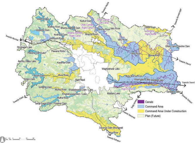
In Pune district, the maximum numbers of irrigation projects are in Baramati, Junnar, Khed, Mulshi and Shirur talukas whereas the talukas with the least irrigation projects are Haveli and Velhe. The location of major and medium irrigation projects (completed and under construction), and command areas (completed and under construction) are shown in Figure 2.8 . Table 2.3 consists of the total area covered under each major irrigation project.
Figure 2.8 : Irrigation Command Area
Source: Central Water and Power Research Station, Pune; Water Resources Department, GoM;
Table 2.3Pune- total area covered under each major irrigation project
No.1
Name of Source Khadakwasla
Type of Source Major
River Name Mutha
Storage Deta Live55.91
ils of Rese Dead30
rvoir Total85.91
Sanctioned Reservation for use of water Quantity (mm3)
234
Temghar Warasgaon/DasavePanshet
Major Major Major
Mutha Mose Ambi
105.01363.13301.61
2.9512.239
107.96375.36310.61
5
Chaskaman
Major
Bhima
214.5
27.19
241.69
26.44
6
Bhama Ashkhed
Major
Bhama
217.13
13.52
230.65
144.11
7
Ghod
Major
Ghod
137.99
31.31
169.3
12.62
8
Pawana Dam
Major
Pawana
240.97
31.15
272.12
285.77
9
Bhatghar
Major
Velvandi
665.57
7.08
672.65
29.73
10
Gunjawane
Major
Gunjawani
104.48
0.21
104.69
0
11
Mulshi Dam
Major
Mula
522.76
13
535.76
0
12
Upper Andhra Lake/ Thokarwadi
Major
Andra
2.7Environmentally Sensitive Areas
Forest Areas
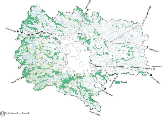
Pune Metropolitan Region is divided into two forest divisions viz. Pune and Junnar forest division and one forest subdivision at Bhor. About 824.29 sqkm (13%) of PMR is under forest division. Table 2.5 presents a taluka wise summary of the area under forest. Figure 2.9 represents the forest area within PMR.
Table 2.5PMR - Taluka Wise Forest areas
Sr No
Taluka
Area under Forest (ha)
Proportion to the total forest area (%)
1
Bhor
48.13
6%
2
Daund
42.55
5%
3
Haveli
123.34
15%
4
Khed
87.29
11%
5
Mawal
234.98
29%
6
Mulshi
177.26
22%
7
Purandar
34.56
4%
8
Shirur
32.7
4%
9
Velhe
43.43
5%
10
Total
824.29
100%
Source: Maharashtra Forest Department, GoM, Pune.
Figure 2.9: PMR-Forest, Western Ghats and Wildlife Sanctuaries
Source: Maharashtra Forest Department, GoM, Pune.
Chapter 2: Physical Features and Environment
Western Ghats
The Western Ghats is an important geological landform on the fringe of the west coast of India and extends over a distance of approximately 1,500 kilometre from Tapi River in the north to Kanyakumari in the south with an average elevation of more than 600 metres and traverses through six states namely, Gujarat, Maharashtra, Goa, Karnataka, Kerala and Tamil Nadu. The Western Ghats is a global biodiversity hotspot and a treasure trove of biological diversity. It harbours many endemic species of flowering plants, endemic fishes, amphibians, reptiles, birds, mammals and invertebrates and is also an important centre of evolution of economically crucial domesticated plant species. UNESCO has included certain identified parts of Western Ghats in the UNESCO World Natural Heritage List because the Western Ghats is a Centre of origin of many species and home for rich endemic biodiversity and hence a cradle for biological evolution.
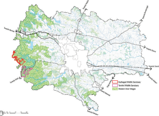
The Ministry of Environment, Forest and Climate Change vide draft notification dated 03/10/2018, in the exercise of the powers under Environment (Protection) Act 1986, has notified the identified area of 56,825 sq km spread across six states as the Western Ghats Ecologically Sensitive Area. Maharashtra has 2,159 villages under Western Ghat admeasuring 55,345 sq km and out of that 17,340 sqkm has been proposed under Environmentally Sensitive Area.
In Pune district, 337 villages with a total area of 2,653 sq km has been proposed under ESA. PMR has 145 villages under the Western Ghats measuring 1,180.6 sq km area (17.5%). These all villages have been included under Ecologically Sensitive Zones I and II.
All ‘Red’ categories of industries specified by the Central Pollution Control Board or State Pollution Control Board and the expansion of such existing industries shall be forbidden. All new and expansion projects of building and construction with a built-up area of 20,000 square metres and above and all new and expansion townships and area development projects with an area of 50 hectares and above or with a built-up area of 1,50,000 square metres and above shall be prohibited. There shall be no restriction on repair or extension or renovation of existing residential houses in the Eco-sensitive Areas as per prevailing laws and regulations.
Table 2.6Western Ghats - Taluka Wise Area
Sr No.
Taluka
Number of Villages
Area (Sq Km)
1
Bhor
4
18.283
2
Khed
0
0
3
Daund
0
0
4
Purandar
5
33.835
5
Shirur
0
0
6
Velhe
16
87.6
7
Haveli
4
29.884
8
Mawal
50
414.00
9
Mulshi
66
597.083
Total
145
1,180.6
Source: The Ministry of Environment, Forest and Climate Change (GR).
Wildlife Sanctuaries
Tamhini Ghat Wildlife Sanctuary
Ministry of Environment and Forest, Government of Maharashtra vide notification dated 3 May 2013, under the provision of wildlife (protection) in 1972 declared the limits of Tamhini WIldlife Sanctuary in Pune and Thane District, admeasuring 49.62 sq km. Thereafter Ministry of Environment of Central Government, vide notification dated 10 August 2017 under the provisions of environment (protection) 1987 notified the area to the extent of 100m to 1200 m from the boundary of Tamhini Wildlife sanctuary as the Tamhini Wildlife sanctuary Eco Sensitive Zone over an area of 15.98 sqkm.
Tamhini Ghat is a mountain passage located between Mulshi and Tamhini in Maharashtra, India. Situated on the crest of the Western Ghat mountain ranges, Tamhini Ghat is known for its surroundings comprising scenic waterfalls, lakes and dense woods. A part of the Sahyadri Hills, the Tamhini Ghat was designated as a wildlife sanctuary in May 2013. Situated 70 kilometres from Pune city, the Ghat is home to a rich and diverse selection of flora and fauna, not to mention its scenic beauty which draws tourists and visitors, especially in the monsoons when it is dotted with waterfalls. The sanctuary is home to various species of mammals, birds including Indian endemic bird species, butterflies, reptiles, invertebrates, and rare flora. Among its wildlife is the Kondana Rat, an endangered species, and Maharashtra, the Indian Giant Squirrel, commonly known as Shekaru. Out of 49.62 sqkm, 35.88 sqkm of Tamini Ghat Wild life Sancturay falls within PMR.
Sudhagad Wildlife Sanctuary
Government of Maharashtra vide notification dated 27 August 2014 under the provisions of wildlife protection act 1972 specified the limits of Sudhagad wildlife sanctuary in Raigad and Pune District admeasuring about 76.88 sq km. Sudhagad is a historic hill fort. It lies about 53 kilometres west of Pune city, 26 kilometres south of Lonavala and 11 kilometres east of Pali in Raigad District. The total area of 76.88 sq km was declared as a wildlife sanctuary on 27th August 2014 under Notification no. WLP. 2014 /CR No. 37/ F-1. The Sudhagad wildlife sanctuary falls under Alibag division, Roha Division and Pune Division of forest department. 26.31 sq.km. of Sudhagad wildlife sanctuary area falls within Pune Metropolitan Region. The sanctuary has dense forests i.e. tropical evergreen forest, evergreen forest and wet deciduous forest and it hosts a variety of species, some of which are enlisted below:
Mammals: Indian leopards, Bhekar, Asian palm civet, Jungle cat
Reptiles: Python, Kobra
Figure 2.10: PMR- Forest Area, Western Ghats and Wildlife Sanctuaries
Source: Villages under Western Ghats as per Ministry of Environment and Forest, Section 5 of Environment Protection Act, 1986; Wildlife Resource Instutite.
Chapter 2: Physical Features and Environment
363.7
0
363.7
0
13
Shirwata
Major
Indrayani
212.97
0
212.97
0
Source: Central Water and Power Research Station, Pune; Water Resources Department, GoM;