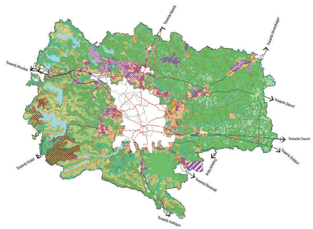
The Pune Metropolitan Region (PMR) is spread over 6,914.26 sq. km. area, comprising of 814 villages and has a total population of 73,21,367 as per Census 2011. It is the largest Metropolitan Region in Maharashtra followed by MMR, NMR and NMA, and third
largest in the country in terms of area after Bangalore and Hyderabad. Pune Metropolitan Region Development Authority (PMRDA) is the planning and development authority for the PMR with an outlook towards channelizing growth in a strategic and orderly manner.
Area: 6,914.26 sq.km. Population : 73,21,367 Villages: 814 tion
PMR is strategically located in India’s Golden Quadrilateral. The Region is well connected to major cities and regions like Mumbai and economic activities like JNPT and Dighi ports. PMR has good connectivity with Satara, Bangalore, Ahmednagar and Solapur through a network of National Highways.
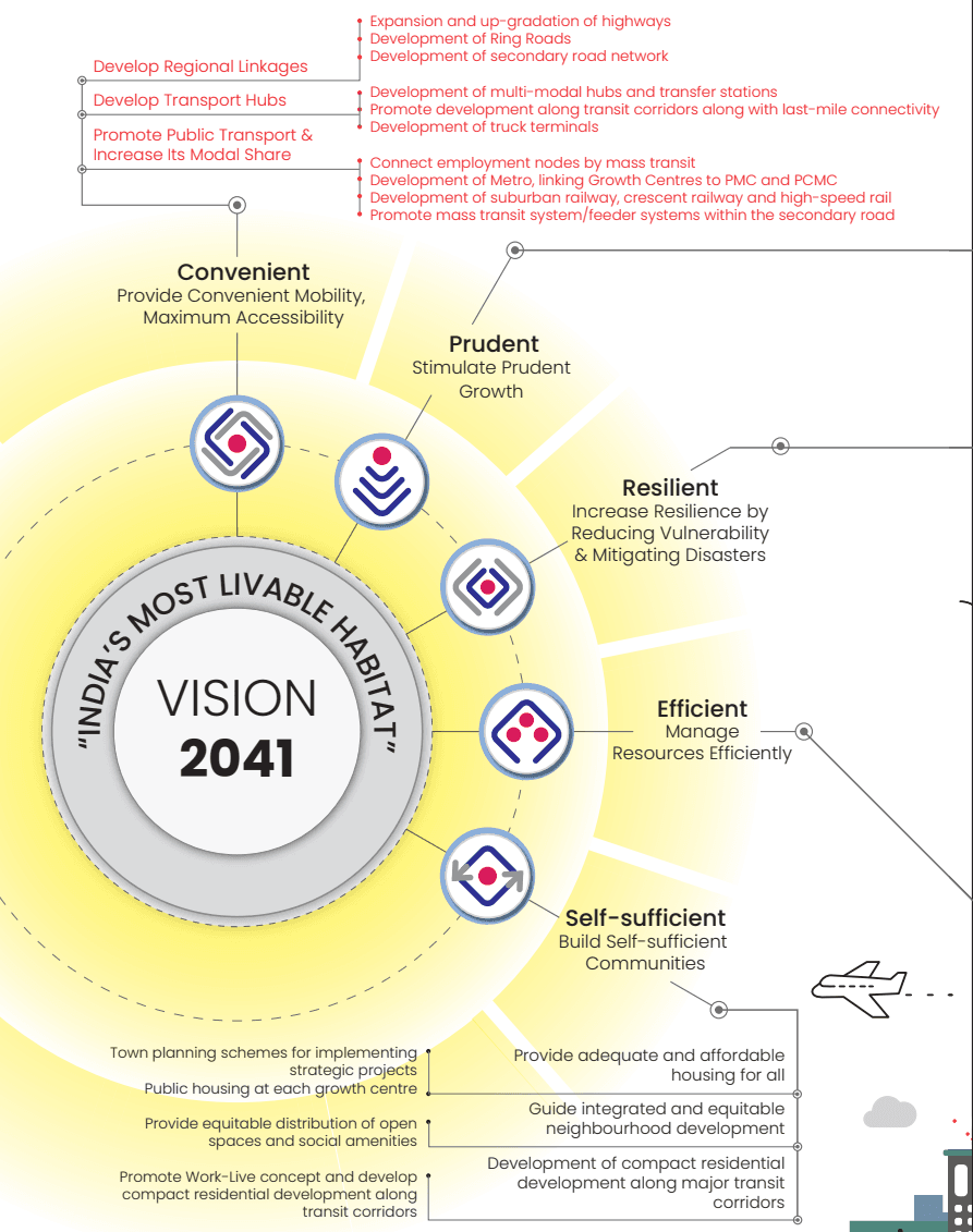
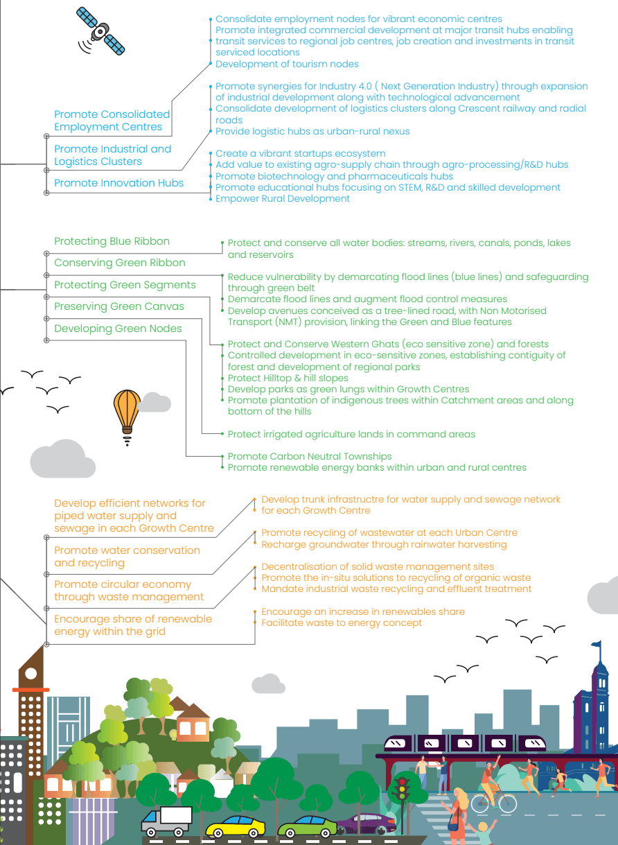
PMRDA has prepared the Draft Development Plan for PMR that is envisioned for 2041 with an intent to promote integrated and inclusive growth and guide the present and future sustainable development of rural areas, towns and cities.
2. Planning Area
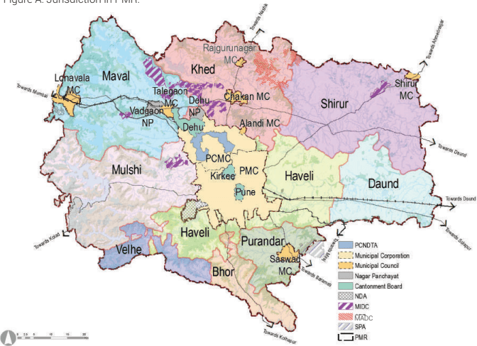
PMRDA has been appointed as SPA for the area not covered under any local authority and also has been appointed for the 23 villages in Pune Municipal Corporation, as per Maharashtra Regional and Town Planning Act, 1966. Two municipal corporations, seven municipal councils, three cantonment boards, two nagar panchayats have statutory plans either in effect or under process as per the relevant provisions of the MRTP Act, 1966. In addition to these, Maharashtra Industrial Development Corporation (MIDC) is the planning authority for the area under its jurisdiction. Thus, the Planning Area herein refers to 804 villages - including 23 villages under PMC and 10 census towns. Total Planning Area is 6,051.62 sq km. It excludes planning jurisdictions of two municipal corporations, seven municipal councils, three cantonment boards, two nagar panchayats and SPAs - MIDC, MADC within PMR.
Study Area: As such, PMRDA does not have control over development within MIDC and MADC areas. However, considering the existing and future roles of these jurisdictions as drivers of economic growth, these jurisdictions have been included in the planning analysis. Thus, the Study Area refers to the PMRDA planning jurisdiction of 804 villages- including 23 villages under PMC, 10 census towns and jurisdiction of MIDC, MADC, covering 6159.32 sq km of total area. Bifurcation of the PMR area is provided in following figure.
Figure A: Jurisdiction in PMR.
3. Development of erstwhile PMR since 1997
The Regional Plan (RP) for PMR was prepared in 1997 for horizon year of 2011 covering the Pune District. The RP has been guiding the growth of PMR since 1997. Its intention was to achieve deconges tion of Pune Metropolis (old Pune Municipal Corporation, Pimpri Chinchwad Municipal Corporation limits) and other areas, by developing new peripheral industrial ring towns around Pune City and creating employment opportunities closer to the rural areas, to curb rural- urban migration and conges tion of the Metropolis. Assessment of development pattern or growth in PMR in the year 2018 reveals that, the ‘decentralised’ model of development has not been successful, because of:
Decentralized Ring towns planned with only zoning without public amenities, has resulted into skilled and educated industrial workers preferring to live in PMC and PCMC areas, leading to increase in residential density of the Corporations
Weak work-live relation due to the absence of efficient mass transport system and lack of dedicated freight corridors further multiplied congestion levels in PMC and PCMC areas.
Non-flexibility for accommodating future economic drivers: Future economic drivers such as IT Sector, logistics, etc. or development of tertiary sector was not envisioned. Thus development of IT Sector in Hinjawadi proved to be a major disruptor that changed urban development dynamics of Pune agglomeration
Limitations on technological inputs aiding the planning process such as GIS and similar other softwares
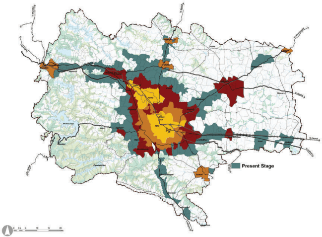
The Figure B shows the present stage urbanizing areas in PMR.

II
Figure B: Present stage urbanisation in PMR.
4. Understanding the urbanisation potential of PMR
As per Census 2011, around 91% of the Study Area was living in rural areas. However, after carrying out the existing landuse survey for mapping of existing activities in 2017-18 revealed that many rural villages have been subsumed by the urban sprawl. Considering the limitation of census definition, parameters of assessment have been broadened to represent Study Area’s actual urban- rural composition. Assessment is based on 13 parameters as given below: Based on scoring criteria assigned to each parameter, there are 233 villages which are complying with parameter 1,2,3 and at least 3 parameters from 4-8, indicating immediate ‘need and ‘opportunity’ for a planned urban development respectively. These villages occupy
27% of PMR’s land area and accommodates about 63% of its population, based on 2018 estimates.
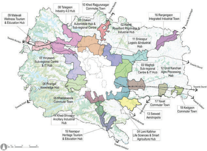
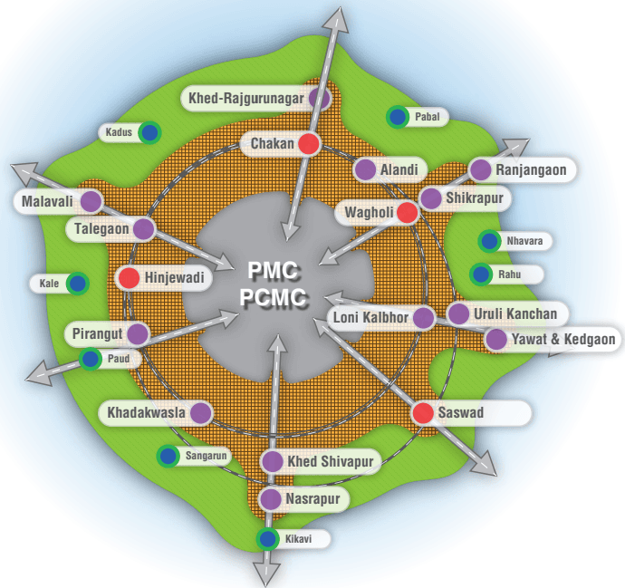
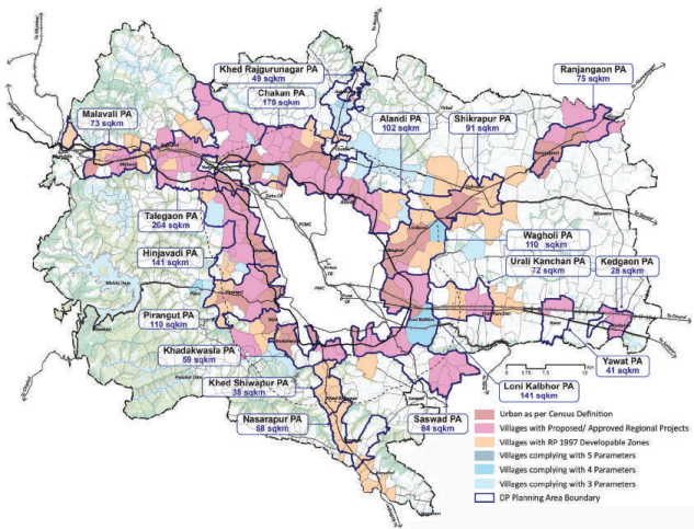
On the other hand, remaining 581 villages do not represent urbanisation pressure nor substantial demographic growth; accommodate 37% of population (2018) of the Study Area; and sparsely spread over 73% of its land area. Above figures clearly indicate that PMR’s urban population share has already surpassed the rural. Considering this, a need arises to prioritise ‘consolidated’ development of 233 villages, which are grouped into 18 Growth Centres (DP Planning Areas), by preparing Development Plans as shown in following figure
III
Figure C: Urbanisation Potential Assessment
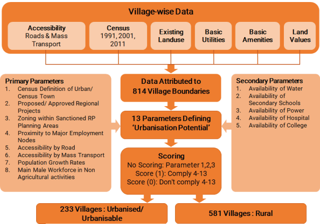
No scoring means village considered as Urban if it satisfies Parameter 1,2,3.
Figure D: Urban Growth Centre Boundaries
IV
However, dependence of rural areas on urban areas need to be reduced, making the rural areas self-reliant while improving the rural living condi tions by providing required social facilities. Thus, rural catchments situated beyond 5km distance from the boundary of Urban Growth Centres need to be served by the Rural Growth Centres, which host the required amenities. Rural Growth Centre are identified based on following criteria:
Strategically located village with access by national/ state level highway;
Central location of village within rural catchment;
Presence of some higher order amenities;
Population higher than the region’s average population per village (>2000);
Administrative centre (headquarter of a circle level as per revenue department)
5. Demographic and Economic Characteristics of PMR:
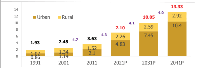
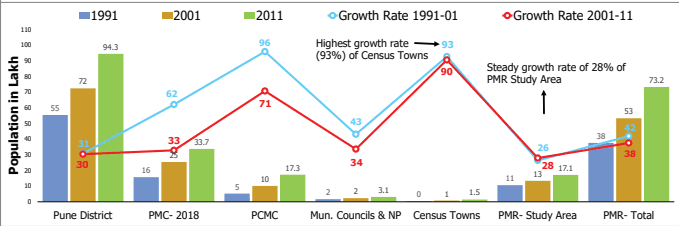
“In reality, the Study Area is rapidly urbanising, out-pacing the rural population growth rate.” The average decadal growth rate of urban population in the Study Area was 90% between 2001-11. This decadal growth rate is higher than that of PMC (33%) and PCMC (71%) during the same period. PMC’s declining population growth rate can be attributed to the increased cost of living, high land prices, sluggish natural growth rate, congestion and declining quality of life. Spin-offs from this trend can be seen as an increase in urban population around its immediate fringes, i.e. urbanising villages of Study Area and PCMC.
The Study Area has excellent potential to urbanise with emphasis on offering the best “Quality of Living” to benefit from present demographic growth trends within the region.
Figure E: Population Growth Rate Trends
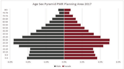
“Broad base of young and working-age population.” Age-group wise distribution is studied at District level since Census 2011 data is limited to age group 0 to 6. Age-group pyramid indicates a favourable situation with a broad base of the young and working-age population.
V