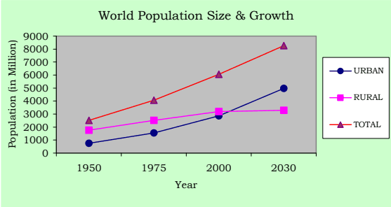
History of the world during the last century has shown that the process of urbanisation and economic growth progress are mutually reinforcing. Cities are the loci and motors of economic and social change. According to United Nations Projections, the World's urban population will grow from 2.86 billion in 2000 to 4.98 billion by 2030 and the World's annual urban growth rate is projected as 1.8 per cent in contrast to the rural growth rate of 0.1 per cent. About 60 per cent of the World's population will live in cities by 2030.
Table No.3.01: World Population Size and Growth, Urban and Rural
Mid-year population size (million)
Population growth rate (percent)
1950
1975
2000
2030
1950-75
1975-00
2000-30
Urban
World Total
751
1543
2862
4981
2.9
2.4
1.8
High-income countries
359
562
697
825
1.8
0.9
0.6
Middle and low income countries
392
981
2165
4156
3.7
3.2
2.2
Rural
World Total
1769
2523
3195
3289
1.4
0.9
0.1
High-income countries
219
187
184
139
-0.6
-0.07
-0.9
Middle and low income countries
1550
2336
3011
3151
1.6
1
0.2
Note: High-income countries have gross national income per capita of US$9266 or more based on World Bank estimates.
Source: National Research Council, 2003, P.85.
1 The state of the World’s cities 2004-05 Globalisation and Urban Culture, published by Earth scan in 2004
Urbanisation in India
3.02 India, the second largest populous country in the World has one of the longest urban traditions. By the year 2000 BC itself India had an extensive network of towns. Even before the British traders made contact with India (by AD 1600), there was broad regional distribution of towns. These towns were not just of administration, but also of trade and marketing, cultural activities and religious pilgrimage, defence and fortification. New cities - Madras, Calcutta and Bombay were founded by 17th Century. The early British settlements became the means of transforming urban system in India. During the 19th century, the Cities were to be for industrial activities and also became hub of the transport network.
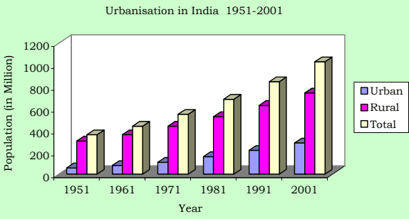
3.03 In a formerly rural economy country like India, because of the need to decrease the number of persons dependent on agriculture and to improve productivity in rural areas, urbanisation is viewed as a prerequisite of growth. The urban population in India has grown from 25.7 million in 1901 to 286.1 million in 2001. After Independence in 1947, the rate of growth of urban population increased from 2.64 percent in 1951 to 3.88 percent in 1981 and thereafter declined to 2.77 in 2001; but the share of urban population to the total population of the country constantly increased from 10.9 percent in 1901 to 15.92 percent in 1951, and thereafter to 27.81 per cent in 2001.
Table No.3.02: Urbanisation in India 1951-2001
Urban
1951
1961
1971
1981
1991
2001
Population (in million)
57.50
78.90
109.10
159.70
217.60
286.10
Annual, Rate of Growth (Percent)
2.64
3.21
3.29
3.88
3.14
2.77
% of urban total population
15.92
17.96
19.90
23.30
25.71
27.81
Rural
Population (in million)
303.60
360.30
439.10
525.50
628.70
742.60
Annual, Rate of Growth
1.02
1.73
2.00
1.81
1.81
1.68
% of rural to total population
84.08
82.04
80.01
76.70
74.29
72.19
Total
Population (in million)
361.10
439.20
548.20
685.20
846.30
1028.70
Annual, Rate of Growth
1.26
1.98
2.24
2.26
2.13
1.97
Source: Census of India
Urbanisation in Tamilnadu
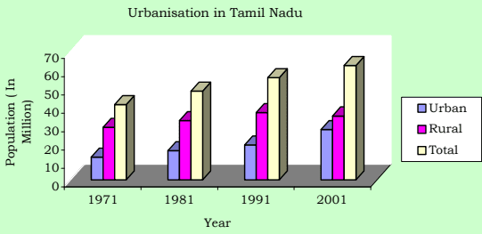
3.04 Tamilnadu has emerged as the third largest economy in India. Cities exist and grow because of economies of urban agglomeration associated with industrial and trade activities. In the recent past, liberalisation, rapidly growing IT sector, an educated, hardworking and disciplined work force etc, accelerating economic development also contributed to the growth of urban areas in Tamilnadu. The extent of the State is 130,058 sq.km. of which the urban area accounts for 12,525 sq.km. Tamilnadu is the most urbanised state in India. It is one of the few states in India with hierarchy of urban areas dispersed fairly uniformly through-out the State. Its urban population has grown from 12.46 million in 1971 to 27.48 million in 2001. Its percentage share of urban population to total population stood always much above the national average.
Table No.3.03: Urbanisation in Tamilnadu (1971-2001)
1971
1981
1991
2001
Urban
Population (in million)
12.46
15.95
19.08
27.48
Annual, Rate of Growth (percent)
3.32
2.50
1.91
3.72
% to total
30.26
32.95
34.15
44.04
Rural
Population (in million)
28.73
32.46
36.78
34.92
Annual, Rate of Growth (percent)
1.53
1.23
1.26
-0.52
% to total
69.74
67.05
65.85
55.94
Total
Population (in million)
41.19
48.41
55.86
62.40
Annual, Rate of Growth (percent)
2.03
1.63
1.44
1.11
Area in Sq.Km.
130,069
130,050
130,050
130,050
Source: Census of India
Growth of population in Chennai city and CMA
3.05 Chennai (earlier called as Madras) was established in 1639, as one of the East India Company's earliest trading Ports and later became the centre of the company's control over Southern India. By 1700, Madras had become a thriving city with about 3 lakhs inhabitants; most of them lived in the Black Town in the north of the British Fort St. George. By the end of the eighteenth century, according to Dupuis (1968), the north of the city had become profoundly different from the south. The north was densely populated, with Black Town, the heart of the city. To the south were the open spaces and scattered settlements of the Europeans. By the time of the first census in 1871, the city had reached over 4 lakh. The first railway line between Madras and Arcot was opened in 1856 and the Madras Port was improved in 1890, which had attracted industrial developments to the north of the black zones renamed as George Town in 1905. The growth of Chennai City continued in the twentieth century and it has grown to the fourth largest Metro City in India.
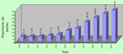
3.06 An area about 67 Sq.km. containing 16 hamlets was constituted as the City of Madras in 1798 and subsequently enlarged from time to time. Its enlargement and growth of population since 1901 is given in table No. 3.04.
Urbanisation in India by Robert W. Bradnock, 1984.
Table No.3.04: Growth of Population in Chennai City, 1901-2001
1901 1911 1921 1931 1941 195
1 1961
1971 1981 1991 2001
C init lyak phospulation 5.41 5.56 5.78 7.13 8.65 14.
27 17.49
24.69 32.85 38.43 43.44
Area in sq.km. 68.17 68.17 68.17 68.17 77.21 128.
83 128.83
128.83 176 176 176
Annual Rate of
g proopwutlhat oiofn * (in -- 0.27 0.39 2.12 0.69 -0.
11 2.06
3.51 -0.27 1.58 1.23
percent)
Population
density per 80 82 85 105 112 1
11 136
192 187 218 247
Hect.
*Note: Arrived for a unit area for the purpose of comparison since the city extent varied over time. The figures given are for the decade ended with that year.
Source: Census of India
3.07 The city Corporation area recorded a higher growth of more than 2% per annum during the decades 1951-61 and 1961-71. The reasons for this rapid growth rate can be attributed to industrial developments and increase in economic activities and employment opportunities in the City and its suburbs attracting large migrant population. The negative growth arrived for a unit area during 1971-81 is due to the annexation of lesser dense (then) Panchayat areas around, to the City viz. Velacheri, Taramani, Kanagam, Thiruvanmiyur, Kodambakkam, Saligramam, Koyambedu, Senjery, Thirumangalam, Virugambakkam, Nesapakkam, Kolathur, Villivakkam, Konnur, Erukkanchery, Jambuli, Kodungaiyur, and Selaivoyal in 1978, comprising about 47 Sq.km.
Growth of Population in Chennai City
3.08 Chennai City Corporation area consists of 155 divisions within 10 zones (Zone No. I to X) presently. The number of these divisions and its extent varied over time. Hence, for the purpose of comparison, the demographic details have been arrived for the years 1971, 1981 and 1991 keeping the 155 Corporation division boundaries in 2001 as the basis. Spatial distribution of population growth in the City is given in the table no.3.05.
Table No. 3.05: Chennai City - Population Growth in Corporation Zones, 1971-2001
Zone Nos.
Corporation Zone
Area in Sq.km.
Population in Lakhs
Annual rate of growth in percent
Density per Hectare in 2001
1971
1981
1991
2001
71-81
81-91
91-01
I.
Tondiarpet
17.30
2.01
2.69
3.72
4.10
2.95
3.28
1.00
243
II
Basin Bridge
11.52
3.59
3.52
3.27
3.76
-0.21
-0.74
1.40
335
III
Pulianthope
13.51
3.34
4.13
4.31
4.60
2.13
0.44
0.64
349
IV
Ayanavaram
19.76
2.22
3.58
4.12
4.97
4.89
1.42
1.89
258
V
Kilpauk
26.38
2.18
3.45
4.94
5.42
4.68
3.66
0.93
211
VI
Ice-House
10.15
3.27
3.49
3.20
3.42
0.63
-0.84
0.65
346
VII
Nungambakkam
12.90
2.91
3.09
3.20
3.48
0.61
0.35
0.83
277
VIII
Kodambakkam
13.00
2.48
3.33
4.39
4.66
2.96
2.81
0.61
368
IX
Saidapet
23.56
1.89
2.61
3.33
4.15
3.25
2.48
2.23
180
X
Mylapore
27.92
2.50
2.97
3.95
4.88
1.70
2.89
2.13
180
City Total
176.00
26.42
32.85
38.43
43.44
2.20
1.58
1.23
247
Source Census of India
3.09 Population growth in different zones within City Corporation area is found to be not uniform and its rate varied from 0.61% to 2.23%; Saidapet and Mylapore zones have recorded growth rate exceeding 2% during 1991 - 2001.
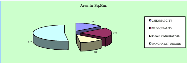
3.10 Chennai Metropolitan Area comprising City of Chennai and contiguous area around was notified in 1974. It extends over 1189 sq.km. and includes Chennai City Corporation area, 16 Municipalities, 20 Town Panchayats and 214 villages comprised in 10 Panchayat Unions.
Table No. 3.06: CMA - Population Growth in Municipalities - 1971-2001
No.. l S
Municipality
.m k Sqn. iaer A
Population in thousands
Annual Rate of growth in percent
itre psy 0021t. Dne Hce
1971
1981
1991
2001
71-81
81-91
91-01
Avg.
1
Kathivakkam
4.75
16.14
22.10
27.17
32.59
3.19
2.09
1.84
2.37
69
2
Thiruvottiyur
21.35
82.85
134.01
168.64
212.28
4.93
2.32
2.33
3.19
99
3
Madhavaram
17.41
21.05
29.46
49.26
76.09
3.41
5.28
4.45
4.38
44
4
Ambattur
37.77
45.59
115.90
215.42
310.97
9.78
6.39
3.74
6.64
82
5
Avadi
61.57
77.41
124.70
183.22
229.40
4.88
3.92
2.27
3.69
38
6
Poonamallee
6.55
18.72
23.67
28.83
42.60
2.37
1.99
3.98
2.78
65
7
Thiruverkadu
18.63
13.08
17.23
27.84
32.20
2.79
4.92
1.47
3.06
17
8
Maduravoyal
4.78
6.46
7.45
14.88
43.61
1.44
7.17
11.35
6.65
91
9
Valasarawakkam
2.97
2.41
7.58
21.95
30.98
12.12
11.22
3.50
8.95
104
10
Alandur
8.08
65.04
97.45
125.24
Source; Arrived based on Census figures
3.11 The high growth rate of more than 5% was found in Ambattur, Maduravoyal, Valasaravakkam, Ullagaram-Puzhithivakkam, Manali and Pammal Municipalities. Kathivakkam, Poonamallee, Alandur and Tambaram Municipalities recorded low growth rates and the rest fall under moderate growth rate category. Maduravoyal Municipality recorded the highest growth rate of 11.35% in the last decade 1991-2001.
Table No.3.07: CMA - Population Growth in Town Panchayats - 1971-2001
Sl. No.
Town Panchayat
Area in Sq.Km.
Population (in thousands)
Annual Rate of growth
itre psny 0021tce. De H
1971
1981
1991
2001
71-81
81-91
91-01
Avge.
1
Minjur
8.63
7.24
13.62
19.49
23.74
6.52
3.64
2.00
4.05
28
2
Chinnasekkadu
1.67
2.21
2.68
8.42
9.74
1.95
12.13
1.46
5.18
58
3
Puzhal
6.74
6.94
9.26
15.87
20.64
2.93
5.53
2.66
3.71
31
4
Naravarikuppam
20.76
9.96
14.67
17.41
18.33
3.95
1.72
0.52
2.06
9
5
Thirunindravur
14.56
6.94
9.13
16.31
29.33
2.78
7.78
4.27
4.94
20
6
Porur
3.72
3.54
8.63
19.51
28.92
9.33
8.49
4.02
7.28
78
7
Thirumazhisai
7.25
9.56
11.01
14.54
16.29
1.42
2.82
1.14
1.79
22
8
Mangadu
5.63
10.98
11.23
16.06
19.42
0.22
3.64
1.92
1.93
35
9
Nandambakkam
2.61
4.72
7.68
10.56
9.34
4.98
3.24
-1.22
2.33
36
10
Meenambakkam
3.03
2.51
3.09
3.80
3.61
2.13
2.09
-0.52
1.23
12
Source; Arrived based on Census figures
3.12 From the above, it may be seen that Chinnasekkadu, Porur, Perungalathur, Peerkkankaranai, Chithalapakkam, Sembakkam, Madambakkam, Perungudi and Pallikkaranai Town Panchayats had high growth rates exceeding 5% and Minjur, Puzhal, Thirunindravur, Thiruneermalai and Sholinganallur had recorded moderate growth rates in population; the rest have low growth rates of below 3%.
Table No. 3.08: CMA - Population Growth in Panchayat Unions - 1971-2001
S.No
. Pa Uncnhioanyat
Population An <sub>Area</sub> <sub>in</sub> <sup>Sq</sup>.Km <sub>1971</sub> <sub>1981</sub> <sub>1991</sub> <sub>2001</sub>