Chapter 21Propsed Land- Use (submitted under Section 16)
SUDA prepared and submitted the Draft Development Plan - 2035 under section 9 to the State Government on 9th May, 2016 for the area admeasuring 1351Km². As per the statutory requirement the same was published in the Official Gazette the on 10th May 2016 under section 13 for inviting public opinion. The notice was also issued in the prescribed manner in the Gujarati daily on 11th May, 2016 inviting suggestions and objections from the general public within the statutory time limits of two months.
As per the provisions of section 14 of the amended Act, 1976, SUDA has to submit the Draft Development Plan - 2035 to the State Government along with opinion on such objections and suggestions. As section 15 of the Gujarat Town Planning and Urban Development Act, 1976 was deleted by the Gujarat Act No. 11 of 2014 which came into force from 21.01.2015, SUDA is now required to submit the Draft Development Plan -2035 along with the Draft GDCR under section 16 of the Act, 1976 for the State Government's approval.
21.1Exclusion of Villages
In the meantime, Government of Gujarat, in exercise of the powers conferred by sub-section (2A) of section 22 of the Gujarat Town Planning and Urban Development Act, 1976 sub divided the area of Surat Urban Development Authority and constituted Khajod Urban Development Authority under sub section (4) of section 22 of the said Act by notification No. GH/V/144 of 2016/DVP-142015-2441-L dated 19.07.2016. Thus, Khajod village of Chorayasi Taluks was deleted from the jurisdiction of SUDA.
Later on, prior to submission of the Draft DP - 2035 under section 16, Government of Gujarat, in exercise of the powers conferred by the sub-section (2A) of section 22, under notification No. GH/V/199 of 2016/UDA-102014-5026(3)-L dated 24.10.2016, excluded 54 villages (50 wholly and 4 partly) out of newly added 100 villages from SUDA jurisdiction. In the said notification, Asnabad village of Olpad taluka which is on the north side of National Highway is shown as excluded from the SUDA jurisdiction, but in fact, there is no National Highway running east west in the said Asnabad village. Thus, total Asnabad village is continued to be part of SUDA jurisdiction. Thus, by the said notification, effectively 53 villages (50 wholly and 3 partly) were excluded from SUDA's jurisdiction.
Few days later, by another notification No. GH/V/200 of 2016/UDA-102014-5026(3)-L dated 03.11.2016, 7 more villages were excluded from SUDA jurisdiction by Government of Gujarat.
Note : Out of 3 villages which are partly included Gamtal of Moje – Paria falls within the jurisdiction of SUDA development area while Gamtal of Moje - Velanja and Sandhiyer fall outside the jurisdiction of SUDA development area. Hence population of Moje - Paria is considered for the total population of SUDA area.
Sine the development area of SUDA was modified and reduced from 1351 Km² to 985 Km² during the period intervening between section 13 and section 16, hence, this chapter has been added as a part of this report.
Urban Development and Urban Housing Department of the Government of Gujarat by the letter dt. 21.11.2016 informed SUDA to submit the Draft Development Plan - 2035 after deleting the villages from the development area of SUDA along with the suggestions and objections received for the proposals on the Draft Development plan - 2035 published u/s 13 in the area remaining in the jurisdiction of SUDA after the notification of 24.10.2016 and 3.11.2016. As per this direction of the State Government, the proposed Land use table gets modified and is discussed below. Since the population of villages which are excluded by the notification of 24.10.2016 and 3.11.2016 amounts merely 1.22 lakhs (as per 2011 census), the population projection for the SUDA area for the target year 2035 has been kept as projected earlier to be 110 lakhs.
21.2Proposed Land Use - 2035
Here it is pertinent to note that the existing polluting industries within Surat city area was proposed to be shifted to village Pinjarat in the huge Government Land in the Draft Development Plan - 2035 published u/s 13 of the Act, on 10.05.2016 and it is proposed that once the polluting industries are shifted than the area so released from the polluting industries may be used for residential development as per the regulations of existing residential zone. However, the village Pinjarat where these industries were planned to be shifted, has now been excluded from SUDA's jurisdiction after Government of Gujarat's notification of 24.10.2016. The industrial shifting zone is continued as proposed in the published Draft Development Plan – 2035. The State Government shall develop the area earmarked earlier for industrial zone in the village Pinjarat by forming a SPV or by any other mode for accommodating the industries shifted out of the industrial shifting zone.
SURAT URBAN DEVELOPMENT AUTHORITY
Page |217
2017
21 PROPSED LAND- USE (SUBMITTED UNDER SECTION 16)
SUDA prepared and submitted the Draft Development Plan - 2035 under section 9 to the State Government on 9th May, 2017 for the area admeasuring 1351Km². As per the statutory requirement the same was published in the Official Gazette the on 10th May 2017 under section 13 for inviting public opinion. The notice was also issued in the prescribed manner in the Gujarati daily on 11th May, 2017 inviting suggestions and objections from the general public within the statutory time limits of two months.
As per the provisions of section 14 of the amended Act, 1976, SUDA has to submit the Draft Development Plan - 2035 to the State Government along with opinion on such objections and suggestions. As section 15 of the Gujarat Town Planning and Urban Development Act, 1976 was deleted by the Gujarat Act No. 11 of 2014 which came into force from 21.01.2015, SUDA is now required to submit the Draft Development Plan -2035 along with the Draft GDCR under section 16 of the Act, 1976 for the State Government's approval.
21.1Exclusion of Villages
In the meantime, Government of Gujarat, in exercise of the powers conferred by sub-section (2A) of section 22 of the Gujarat Town Planning and Urban Development Act, 1976 sub divided the area of Surat Urban Development Authority and constituted Khajod Urban Development Authority under sub section (4) of section 22 of the said Act by notification No. GH/V/144 of 2016/DVP-142015-2441-L dated 19.07.2016. Thus, Khajod village of Chorayasi Taluks was deleted from the jurisdiction of SUDA.
Later on, before the Draft DP - 2305 could be submitted under section 16, Government of Gujarat, in exercise of the powers conferred by the sub-section (2A) of section 22, under notification No. GH/V/199 of 2016/UDA-102014-5026(3)-L dated 24.10.2016, excluded 54 villages (50 wholly and 4 partly) out of newly added 100 villages from SUDA jurisdiction. In the said notification, Asnabad village of Olpad taluka which is on the north side of National Highway is shown as excluded from the SUDA jurisdiction, but in fact, there is no National Highway running east west in the said Asnabad village. Thus, total Asnabad village is continued to be part of SUDA jurisdiction. Thus, by the said notification, effectively 53 villages (50 wholly and 3 partly) were excluded from SUDA's jurisdiction.
Few days later, by another notification No. GH/V/200 of 2016/UDA-102014-5026(3)-L dated 03.11.2016, 7 more villages were excluded from SUDA jurisdiction by Government of Gujarat.
Note : Out of 3 villages which are partly included Gamtal of Moje – Paria falls within the jurisdiction of SUDA development area while Gamtal of Moje - Velanja and Sandhiyer fall outside the jurisdiction of SUDA development area. Hence population of Moje - Paria is considered for the total population of SUDA area.
Sine the development area of SUDA was modified and reduced from 1351 Km² to 985 Km² during the period intervening between section 13 and section 16, hence, this chapter has been added as a part of this report.
Urban Development and Urban Housing Department of the Government of Gujarat by the letter dt. 21.11.2016 informed SUDA to submit the Draft Development Plan - 2035 after deleting the villages from the development area of SUDA along with the suggestions and objections received for the proposals on the Draft Development plan - 2035 published u/s 13 in the area remaining in the jurisdiction of SUDA after the notification of 24.10.2016 and 3.11.2016. As per this direction of the State Government, the proposed Land use table gets modified and is discussed below. Since the population of villages which are excluded by the notification of 24.10.2016 and 3.11.2016 amounts merely 1.22 lakhs (as per 2011 census), the population projection for the SUDA area for the target year 2035 has been kept as projected earlier to be 110 lakhs.
21.2Proposed Land Use - 2035
Here it is pertinent to note that the existing polluting industries within Surat city area was proposed to be shifted to village Pinjarat in the huge Government Land in the Draft Development Plan - 2035 published u/s 13 of the Act, on 10.05.2016 and it is proposed that once the polluting industries are shifted than the area so released from the polluting industries may be used for residential development as per the regulations of existing residential zone. However, the village Pinjarat where these industries were planned to be shifted, has now been excluded from SUDA's jurisdiction after Government of Gujarat's notification of 24.10.2016. The industrial shifting zone is continued as proposed in the published Draft Development Plan – 2035. The State Government shall develop the area earmarked earlier for industrial zone in the village Pinjarat by forming a SPV or by any other mode for accommodating the industries shifted out of the industrial shifting zone.
SURAT URBAN DEVELOPMENT AUTHORITY | Page | 217
C C C C C C C C C C C C C C C C C C C C C C C C C C C C C C C C C C C C C C C C C C C C C C C C C C C C C C C C C C C C C C C C C C C C C C C C C C C C C C C C C C C C C C C C C C C C C
2017
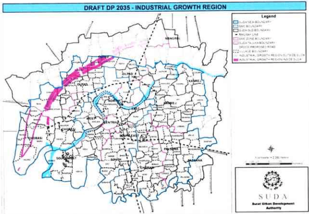
Moreover, SUDA has conceived the plan to develop industrial growth region having 1.445 km width from Hazira to the existing BG Delhi Mumbai railway line near Gothan admeasuring. But this SIGR (Surat industrial Growth Region) proposed through Sandhiyer, Khalipor, Madhar, Kareli and Bharundi villages, which are excluded from SUDA's jurisdiction after Government of Gujarat's notification dated 24.10.2016 is now affected.
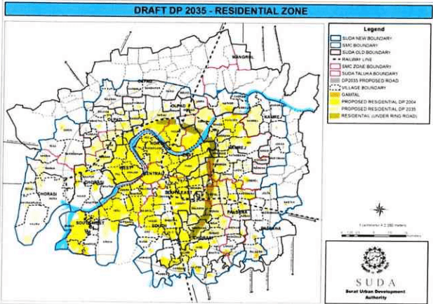
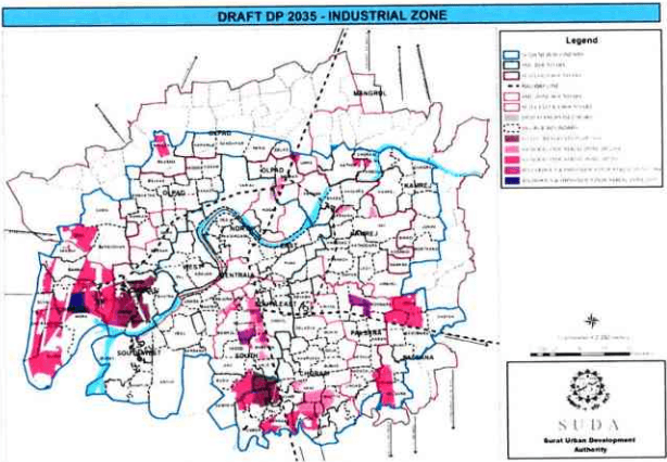
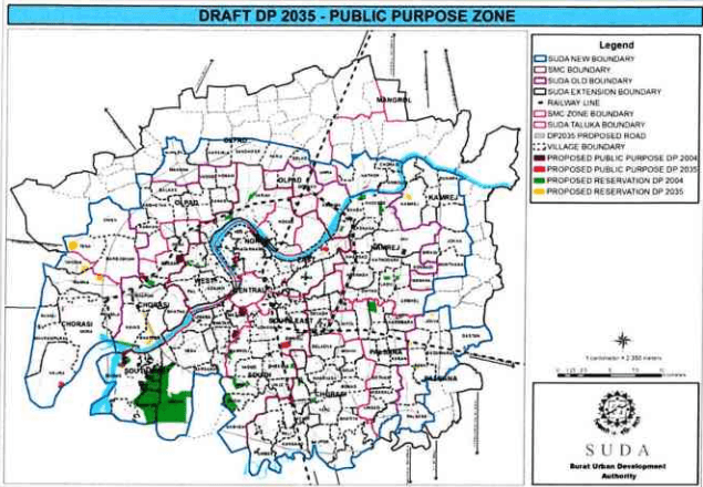
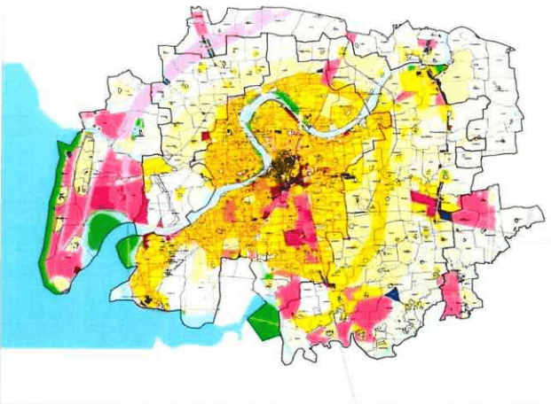
The zoning proposal in the new development area after exclusion of villages is shown in the Figures below.
Figure 69 Map showing all Residential zone
DEVELOPMENT PLAN 2035 | 2017
Figure 70 Map showing all Industrial growth region
Figure 71 map showing industrial zone
SURAT URBAN DEVELOPMENT AUTHORITY | Page |219
C C C C C C C C C C C C C C C C C C C C C C C C C C C C C C C C C C C C C C C C C C C C C C C C C C C C C C C C C C C C C C C C C C C C C C C C C C C C C C C C C C C C C C C C C C C C
2017
Figure 72: Public Purpose Zone Proposals - DP 2035
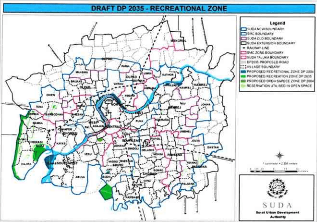
Figure 73 Recreational Zone Proposals- DP 2035
SURAT URBAN DEVELOPMENT AUTHORITY | Page |220
DEVELOPMENT PLAN 2035 2017
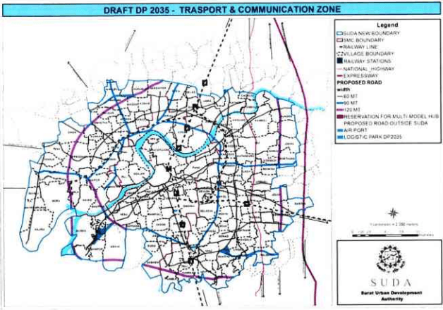
Figure 74 map showing all transportation link and communication zone
The proposed land use of the SUDA area in the 985.16 Km² for the target year of 2035 after exclusion of villages now remains is shown in the table below. The existing landuse and landuse proposed at the time of publication u/s 13 is also mentioned in the said table.
- C C C C C C C C C C C C C C C C C C C C C C C C C C C C C C C C C C C C C C C C C C C C C C C C C C C C C C C C C C C C C C C C C C C C C C C C C C C C C C C C C C C C C C C C
2017
Table 154Proposed Land use - 2035
Landuse
Existing - 2015
Proposed - 2035 (u/s 16)
Proposed - 2035 (u/s 9)
Area Km2
%age of Urbanize d Land
Area Km2
%age of Urbanize d Land
Area Km2
%age of Urbaniz ed Land
1 Residential
123
48
346.73
50.93
357.67
45.45
Residential Zone DP - 2004
166.54
166.54
Proposed Residential Zone DP- 2035
144.63
150.80
Residential Zone 90 m ORR
20.06
20.06
Gamtal
11.15
14.20
Industrial Shift Zone
4.35
4.35
2 Commercial
5
2
10.48
1.53
11.82
1.50
3 Industrial
67
26
112.96
16.59
136.30
17.32
General Industrial Zone
100.89
117.19
Obnoxious and Hazardous Industrial Zone
12.07
19.11
4 Public Purpose
14
6
47.87
7.02
63.16
8.03
Public Purpose Zone
10.41
11.07
Educational Zone
5.57
6.10
Reservations
31.89
36.54
DREAM City Zone
-
9.45
6 Recreational
2
1
39.48
5.80
45.97
5.84
7 Traffic and Transportation
44
17
95.26
13.99
131.89
16.76
Transportation Zone
94.46
131.09
Logistics Park
0.80
DEVELOPMENT PLAN 2035 | 2017
Urbanized area
255
100
680.92
100
786.90
100
Agriculture
730
235.45
472.58
Water Bodies and Other Non-Urbanized Area
68.79
92.05
Total SUDA
985
985.16
1351.53
As per the proposed landuse table, the composition of urbanised and non-urbanised area is shown in the Table below.
Table 155comparison of composition of SUDA area
Proposed in 2004 DP for 2011
Existing - 2015
Proposed – 2035 (u/s 16)
Proposed – 2035 (u/s 13)
Area (Km2)
%age
Area (Km2)
%age
Area (Km2)
%age
Area (Km2)
%age
Urbanised
312.51
44
255
26
680.92
69
786.90
58
Non- urbanised
409.49
56
730
74
304.24
31
564.63
42
Total SUDA
722.00
100
985
100
985.16
100
1351.53
100
The urbanised area has increased from 58% to 69% as the rural settlements excluded from the SUDA boundary mainly comprises of non-urbanised proposed agricultural zone.