8.2Vehicles - Per Capita Growth and Its Implications on
Congestion
The vehicles registered in Surat RTO area has raised from four lakhs (in 1994) to thirty six lakhs (in 2012). Two wheelers comprise nearly 40% of the total number of vehicles while cars constitute about 17%. Currently, Surat has approximately 14 lakhs two wheelers and eighty five thousand auto rickshaws registered. The break-up of the vehicular composition in the city and the percentage change in the city is shown in table below:
Table 40Growth of vehicles registered at Surat
Sr.No.
Type of Vehicle
Number of Vehicles
% Change per Year
2009-2010
2010-2011
2011-2012
2010-2011
2011-2012
1
2 Wheeler
12,70,400
13,70,899
14,95,610
7.3
8.3
2
3 Wheeler
74,814
79,980
84,099
6.5
4.9
3
Car
1,65,508
1,89,370
2,20,932
12.6
14.3
4
All Vehicles
30,81,994
33,46,031
36,74,266
7.9
8.9
The rate of growth has remained high at 9-10%. In the absence of public transport system in the city, the rate of increase in auto-rickshaws has been approximately 4.5 % whereas rapid increment in the rate of motorcars has been observed in last year, is approximately 10-10.5%.
Chapter 8Traffic and Transportation
The city is well connected by road, rail and air transport. Several National and State Highways pass through the city. It is also connected by the sea port. As a result, traffic coming to as well as passing through the city is very high. The city transportation system is predominantly road based. With the absence of a public transport system, dependence on individual modes and intermediate public transport is high. Though roads are generally wide, network design and development is not complete.
8.1 Introduction
8.1.1 Regional Linkages
Railways: Surat is served by the busy north-south line of the Western Railways connecting Gujarat with Mumbai and other important centres. Branches of the railway line serve areas of Udhna, Jalgaon and Bhestan. A dedicated goods' line exists between Kosad to Hazira. Being located midway between Ahmedabad and Mumbai, the city is serviced by express, mail, passenger and local trains. The main line carries a lot of freight traffic due to the industrial belt between Ahmedabad and Mumbai and the sea ports in Gujarat and Mumbai. Three railway stations fall within the city area. The main station (Surat Railway Station) is located just outside the walled city abutting the ring road. The railway station at Udhna is also an important transport node within the city. The third railway station located at Utran is not significant as the development in the area is limited. Sachin and Maroli are located towards south of Surat.
Road Transport: Gujarat State Road Transport Corporation (GSRTC) is the regional public transport operator in Gujarat. Following are the key facilities for its intercity and inter-state services:
• The central depot is located near Railway Station (in the east)
- ST Terminal is located near Railway station (in the west). This is supported by linear terminal on ring road nearby.
- A terminal is located near Adajan Patiya (West of Nehru Bridge). This has additional facilities such as workshop, parking, etc.
- Near Udhna village, originally the bus depot was used for city bus services. With the start of bus service, the city has started utilizing the place as terminal.
The linear bus stand near railway station, Wadi Faliya and Kanskiwad were the main terminal points for city bus services. All these have been converted as city bus terminals starting from August 2007. Jeeps and matadors carry out passenger and goods services to the neighbouring villages and towns. Private bus operations also provide inter-city bus transport to various cities from Sahara Darwaja. In the absence of a separate bus terminal for private operators, their operations result in traffic congestion at Sahara Darwaja.
Air Port: The existing airport catering to domestic traffic is located to the south-west on the Surat-Dumas radial road. Daily air services to Delhi, Mumbai have begun recently.
Page
C C C C C C C C C C C C C C C C C C C C C C C C C C C C C C C C C C C C C C C C C C C C C C C C C C C C C C C C C C C C C C C C C C C C C C C C C C C C C C C C C C C
2017
narrower. In old city, the area under roads (area of 28.29 sq.km.) is about 25% of the total area of old SMC limits. The road length within this area is 967 km. However, not all roads are developed to their full width.
Table 38Road length of various type of roads in Surat
Sr.No.
DESCRIPTION.
GRAND TOTAL
Surfaced (km)
Unsurfaced (km)
W.B.M.
B.T.
C.C.
Total(4+5+6)
Motorable
Non-motorable
Total
1
2
3
4
5
6
7
8
9
10
1
Total road length as on 31.3.2012
2170
362
1524
32
1919
79
172
252
2
Road length added during 1.4.2012 to 31.3.2013.(New roads)
370
132
119
0
252
64
53
117
3
Total road length as on year ended 31.3.2013 (total of Sr.No.1 & 2).
2540
494
1644
32
2171
145
225
369
Page | 62
DEVELOPMENT PLAN 2035 2017
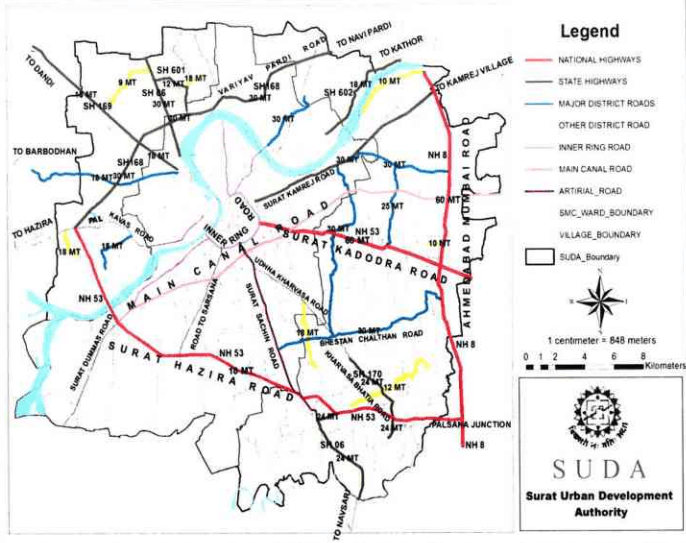
Figure 32: Existing road network map of SUDA
EXISTING REGIONAL ROAD NETWORK
Table 39Road length details
Sr. No.
Road Name
Length (km)
BT Length (km)
CC Length (km)
1
Inner Ring Road
11.40
4.4
7
2
Canal Road
8.80
8.3
0.5
3
Katargam Amroli Road
7.20
6.8
0.4
4
Varacha Road
6.70
4.4
2.3
5
Udhana Sachin Road
4.80
2
2.8
6
Udhana Magdalla Road
4.20
4.2
7
City light Road
2.50
2.5
8
Hazira Road
1.40
1.4
C C C C C C C C C C C C C C C C C C C C C C C C C C C C C C C C C C C C C C C C C C C C C C C C C C C C C C C C C C C C C C C C C C C C C C C C C C C C C C C C C C C C C C