The first step in preparation of development plan is the identification of the land use characteristic and existing city structure situation. Detailed survey of existing situation has been made withal length in part one of the report. While formulating the proposals of development plan, the following broad principles have been kept in view.
- To have optimum utilization of urban land and to minimize the spread of urbanization in rich agricultural irrigated area
- To develop multi modular transportation considering high growth of city and upcoming national projects such as DFC, EW, Metro, Bullet train, DREAM City, etc. and creating transportation corridor by way of ring roads, DP Road and radial conduit roads
- To decongest the city by locating new development areas to ease the pressure on city Providing balanced development with environmental protection and adequate green spaces
• Diversification of economic activities
Thus, the main objectives of the development plan would be to achieve efficient functioning by restructuring the city, by means of conservation, new development and to serve as a policy framework with long term perspective to guide future developments. One of the important considerations while formulating the revised development plan proposals has been the need to protect the best of existing character of Surat to develop its structure and suggest appropriate measures to overcome remedies obstructing the healthy growth of city.
19.2.1 Plan Area
The present area of Surat Urban Development Authority is admeasured 1351 sq.km. This includes the 326 sq.km. area covered by Surat Municipal corporation and 195 village settlements.
19.3Methodology Adopted
The methodology adopted for the formulation of development plan was to prepare a base map using GIS Techniques and develop GIS database. The data from various surveys and studies available with the SMC and other agencies was collected. Since comprehensive data for the entire plan area was not available, the information regarding existing land use, infrastructure facilities, housing, environment were collected from all 195 villages of SUDA area. For the preparation of the Development Plan, a number of study groups were formed for arriving at the proposals of the Development Plan. All this data was used to work out integrated proposal in the light of the present state of development, with the assessment of the existing conditions and accounting for the potential resources and constraints for future development and trends on the basis of known parameters.
19.4Plan Period
The SUDA had proposed the first development plan in 1980, which was sanctioned by the Government on 31st January, 1986 and came into force from 3rd March, 1986. The first plan was prepared for the plan period up to 2001. The process of urbanization is a continuous phenomenon. Hence the development plan is revised every 10 years. The first revision of development plan was submitted in 1987 which came into force from 15th September, 2014. The plans visions were based on the existing situation prevailing at that time. However the process of planning depends upon a number of variables such as population growth, economic activities, development of counter magnets, and the nature of development. To deal with these factors, it requires to review the development process at moderate time intervals. SUDA has thus taken up the study of the preparing the second development plan to stream line the development to achieve the long term requirements. For preparation of development plan, plan period up to 2035 has been considered. This revised development plan also requires to be reviewed at an interval of 10 years with a view to accommodate and to review the programme of implementation and also to assess requirement and needs created by new technology and new development.
19.5 Existing Conditions and Government Policies
A detailed study and analysis of existing conditions was carried out. This included a land use study and analysis, studying the existing government policies applicable to the concepts considered. Analytical study of the zones and areas developed and requirements were carried out. Digital Elevation Models were prepared to as a part of land suitability analysis for future development to minimize the effects of floods.
19.6Suggestions from Stakeholders
Extensive public consultations and stakeholder meetings were carried out which included experts from several Government and Semi Government institutes, Gram Panchayats, NGOs, educational, research and professional institutes such as SVNIT and eminent citizens of Surat. Eight working groups of experts from various fields were formed focusing on key areas including GDCR, housing and socio economic studies, Public transportation, Physical & Social infrastructure, Environment and Industries. The inputs from the consultations were studied and reviewed, detailed analysis of
2017
existing situation was conducted and proposals for the Development Plan were formulated based on the inferences.
Chapter 19Propsed Land- Use (submitted under Section 9)
19.1 Introduction
The Development Plan, 2035 is prepared considering the demand of projected population of next two decades for the entire area of 1351 sq.km. of Surat Urban Development Authority (SUDA). This total area consists of Surat Municipal Corporation (SMC) Area and 195 villages under SUDA. Surat ranks 4th fastest growing city in a global study of fastest developing cities conducted by The City Mayors Foundation, an international think tank on urban affairs. In fact, it is the fastest growing Indian city in terms of economic prosperity. However, as it continues to grow and expand at such high rate, the residents of the city are facing the issues such as traffic congestion, high cost of housing and real estate, parking issues, lack of public transport, increased demand for amenities, gardens, open spaces and much more. For Surat to grow as a sustainable city with inclusive development, an important industrial hub and commercial centre of the country; it must organize its land resources carefully. Following are some of the major considerations taken into account for deriving and formulating proposals of the Development Plan 2035.
19.7Vision and the Principles of Growth Management
The vision, objectives and the principles were identified after multiple discussions and deliberations played a crucial role in formulating the proposals of this Development Plan. The major principles that shaped the proposals include optimum utilization of urban land, multi modular public transport, creation of green network, encouraging sustainable and affordable development. The vision and principles are further detailed out in the following chapters.
19.8 PLANNING CONCEPT
19.8.1 VISION
In the revised development plan proposals, effort have been made to protect the best existing character of Surat. The vision envisaged for further development of Surat is as below.
An economically vibrant and sustainable Surat with diverse opportunities and rich culture; where all citizens enjoy a safe and liveable environment with good connectivity and infrastructure of Global standards.
19.8.2 AIM
Surat urban development authority is preparing the second revision of development plan for 2035. The aim of this development plan is to
Formulate an efficient, sustainable and inclusive development plan of the SUDA area so as to regulate and guide the planned and balanced urban growth in the region by 2035, resulting in better quality of life of people under the provisions of
Gujarat Town Planning & Urban Development Act, 1976 and
Gujarat Town Planning & Urban Development Rules, 1979
• To act as growth engine of South Gujarat region
• Efficient, safe, sustainable, affordable and multi-modular public transport
- Promotion of green city and environment friendly development
• Diversification of economic activities with hinterland integration
• To facilitate equitable supply of land and resources
SURAT URBAN DEVELOPMENT AUTHORITY |
|187
Page
19.8.3 Principles
These principles are drafted to create and sustain the best character for Surat without losing the original cultural balance. A prosperous and secure future for the city is encapsulated in these principles.
19.8.3.1 Optimum utilization of urban land
The most important natural resource, so as to ensure sustainability and avoid adverse land use conflicts. There is a need to ensure high quality delivery of services of ecosystems that come from natural resource base and to cater to the needs of agricultural requirement.
19.8.3.2 Multi modular public transportation
➢ Enhance mobility options by proposing public transport like metro and integrating it with the existing BRTS routes
- Organizing feeder services to public transport
➢ Decongesting roads by promoting the use of public transport
19.8.3.3 Guided and balanced inclusive development
To have a clear implementation strategy for development that guides development towards the final vision
To support all scales of development so that holistic inclusive development for the benefit of population can take place
19.8.3.4 Facilitating diversification of economy
To promote economic development beyond diamond, textile and Jari Industries for diversification into various fields like IT, medical, tourism, etc.
Support economic activity of various scales at various levels of economic ladder
➢ Encourage industrial development to increase employment
19.8.3.5 Emphasis on green development
Connect the gardens and open spaces and roads with a network of "Green Streets"
Provide adequate gardens, parks and public open spaces
Promote green development through GDCR
19.8.3.6 Preserving water channels/ water bodies/ natural drains
To preserve the water bodies and natural drains by discouraging development around water bodies
To promote agricultural activities surrounding water bodies
2017
19.8.3.7 Improved safety and security environment
To create an environment where safety and security of the population shall be of utmost importance
19.8.2.8 Providing adequate space for recreational activities
There is a lack of recreational activities in Surat. Adequate spaces shall be provided to promote and develop recreational activities in the area
To have spaces for public interactions and informal gatherings for recreation
19.8.3.9 Providing balanced development with environmental protection and adequate green spaces
➢ Promote development that is based on principles and best practices of sustainability
Protect and enhance environmental assets to create development that is environment friendly
19.8.3.10 Shifting of existing industries outside residential area
Shifting of various polluting industries from existing residential zones, negatively affecting the health standards, environment and overall liveability
19.9Locational Challenges
The City of Surat has its locational challenges in terms of water bodies. City has developed along 37 km of Tapi River which is prone to frequent floods. About 60 km of Khadi (creeks) of various width is passing through the Surat city and in SUDA area .There is a huge network of Canals also.
➢ Buffer Area along Khadis
As part of preservation of water bodies, provision of buffer along the Khadis has been made in the Draft Development Plan- 2035 so that the natural flow of water is not obstructed. Width of buffer (marked in green color on land-use map) has been proposed as 10 m/ 20 m depending upon the length of the Khadi. No construction shall be allowed in the buffer area. The Competent Authority shall permit the FSI and built-up area on the basis of original plot area, in lieu of the land affected by the buffer area. This Buffer area may be included in the marginal space.
Surat being close to the Arabian Sea is prone to Cyclone. In future, even Tsunami can not be totally ruled out. These challenges have been given due thought while making land use proposals for 2035.
19.10Other Major Considerations
In regional context, there are other urban development authorities present in South Gujarat. SUDA, Navasari Urban Development Authority, Bardoli Urban Development Authority and Bharuch Urban Development Authority cover almost entire region between Navsari and Bharuch excluding only few villages. In this sense, the entire region could be considered as a big metropolitan area and therefore, the Development Plan 2035 of SUDA should be prepared considering infrastructural needs o this metropolitan region.
SURAT URBAN DEVELOPMENT AUTHORITY |
Page
Based on the Existing land use, upcoming DREAM City project and inclusion of Hazira Industrial Area in the development area of SUDA, major 9 growth nodes could be easily identified. These 9 nodes must be considered while framing the land use proposals for the requirement of 110 lakhs population by 2035. The nine nodes identified are Olpad, Kathor, Kamrej, Kadodara, Palsana, Sahin, DREAM City, Hazira and Tena.
It is pertinent to note that in the Development Plan of 2004, out of total area of 715 sq.km., about 52% of land, i.e. 373 sq.km. was proposed to be urbanized land for the purpose of development. The remaining 48% was put under non-urbanized land use. Considering the additional 100 villages in the SUDA area after December, 2015; the existing land use indicates that out of 1351 sq.km. of the total SUDA area, only 289 sq.km. is under urbanized land use which is about 21% of the tota SUDA area. Considering the additional 60 lakhs population to be acomodated in the SUDA area and important projects like DREAM City, Expressway, DFC, Bullet train, Metro, Premiere institutions in Surat, it is proposed to increase the percentage of urbanized area within the SUDA boundary. Approximately, 787 sq.km. out of 1351 sq.km. area has been proposed as urbanized area and the rest 564 sq.km. (42%) has been proposed under non-urbanized land use for year 2035.
19.11Zoning
To control the development in the newly extended area of SUDA comprising of villages which are not part of the Kathor Development Plan and Hazira Development Plan where urbanizable land use has not been proposed, has been put under Agriculture zone. Since many NA permission might have been obtained by the land owners in this newly extended area where Agriculture zone is proposed, the land owner is allowed to develop the land as per the NA permission irrespective of the Agriculture zone. The layout shall be revised only for the purpose for which the NA order has been obtained.
The proposed urbanized area of SUDA is broadly classified in the following zones:
➢ Residential
Industrial
Commercial
➢ Institutional/ Educational
Recreational
Logistics
➢ Surat Industrial Growth Region
The detailed proposal for each zone is described below:
19.11.1Residential Zone
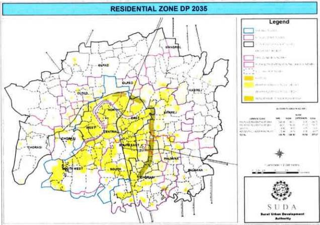
In DP 2004, 204 sq.km. of area including residential zone adjacent to 90 m Outer Ring Road(ORR) was proposed as residential zone. As per the existing land use, about 102 sq.km. residential zone has been consumed, while remaining 102 sq.km. residential zone as per DP 2004 is still left which can be used to cater future demand.
SURAT URBAN DEVELOPMENT AUTHORITY |
Page
|191
C C C C C C C C C C C C C C C C C C C C C C C C C C C C C C C C C C C C C C C C C C C C C C C C C C C C C C C C C C C C C C C C C C C C C C C C C C C C C C C C C C C C C C C C C C
DEVELOPMENT PLAN 2035
2017
According to census 2011 data, total population within SUDA boundary was around 50 lakhs. The population projected for 2035 is 110 lakhs. This means that there is requirement of planning for additional 60 lakhs population which is going to reside in SUDA by 2035. As per the UDPFI Guidelines, the population density for the residential use shall be 250 Per Hectare (PPH). If we want Gross Residential Density of 250 PPH for additional 60 lakhs population, we require 240 sq.km. of residential area. It means we have to propose residential zone to the tune of 342 sq.km. of total area.
While planning for the residential areas, the major factor considered is locating residential zones outside the 'flood-prone' areas. The special attention is given considering the history of frequent floods within SUDA, especially SMC boundaries. For this, a Digital Elevation Model (DEM) of entire SUDA area was prepared. Such model gives details about the area susceptible to inundation under various flood conditions. Once the DEM was ready, it was overlaid on the existing land-use map of SUDA and then location for the new residential areas to be proposed were decided accordingly.
The new residential zone to accommodate the additional population has been proposed considering the DEM. It is proposed to cover the area within SMC boundary for residential zone. After inclusion of land having potential for residential development within SMC area, the proposal for new residential zone has been made within the 90 m ORR. The rest f the residential area has been proposed on the outer side of the 90 m ORR, bounded by 60 m Ring Road. As mentioned earlier, Olpad and Kamrej growth nodes require control by zoning and therefore, these two nodes have been provided with residential zoning. Gamtals as proposed in 2004 DP have been kept intact and continued to be Gamtals. For the natural growth of the villages, the Village Extension Zone has been proposed up to 200 m and 300 m from the boundary of the existing Gamatls depending upon the population of the villages as per Census 2011. If the population is less than 5000, the Village Extension Zone should be 200 m from the boundary of the Gamtal, otherwise it should be 300 from existing Gamtal boundary. The Village Extension Zone shall not be applicable in case of deemed Gamtal.
The existing polluting industries within Surat city area are proposed to be shifted to another area. This area has been proposed for residential zone as per Development Plan, 2035. This residential zone shall be available for residential use only after the closure of the existing industries. Also, about 8.58 sq.km. of land has been proposed for reservation for different acquiring bodies like SMC, SUDA, GHB, PWD, etc. for the purpose of developing these lands for housing. The land under these reservations has been listed in the list of reservations. This area of reservation is not included in the proposed area under residential zone.
The Government of Gujarat has issued guidelines for construction of affordable housing within the development authority area. It is proposed to allow the affordable housing project as per the Government guidelines in any of the urbanized land use. The beneficiaries shall be as per the guidelines of the Government.
Total area proposed under Residential zone (including DP 2004 proposal) is 358 sq.km., which is 45.45% of the total urbanised area proposed in DP 2035.
Page
DEVELOPMENT PLAN 2035 2017
Figure 63: Residential Zone Proposals- DP 2035
19.11.2Industrial Zone
Surat is one of the industrial hubs of the nation, attracting large labour forces from across the nation for employment. This is one of the reasons of large share of migrants' population in the city over the decades. Hazira is one of the biggest industrial centres in the country, housing variety of industries in terms of scale and nature. Hazira is now made a part of SUDA jurisdiction after extension of SUDA in December, 2015 under the State Government's resolution. Other than this, there are other pockets of textile, diamond and Zari industries across the city.
The level of industrial growth over last couple of decades has been tremendous. All the areas proposed as industrial zones in DP 2004 have been occupied by different types of industries and moreover, the areas outside SUDA jurisdiction have experienced high level of industrial development due to the unavailability of industrial zones for development within SUDA. The major industrial zones proposed in DP 2004 and later on developed as industrial pockets are Pandesara GIDC, Udhna GIDC and Katargam GIDC. However, Navagam did not develop to its potential even though it is located in proximity of National highway.
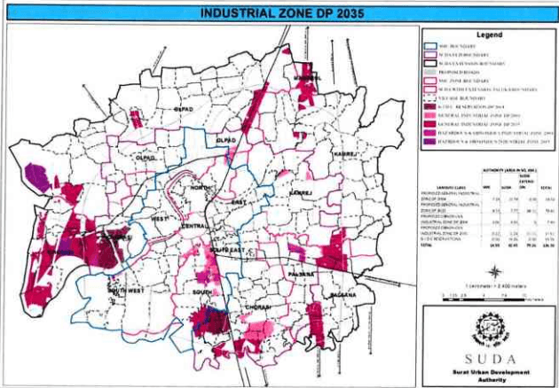
At present, there is hardly any scope of industrial development due to consumption of industrial zone. There are also various polluting industries located within residential zones, negatively affecting the health standards, environment and overall liveability. The existing polluting industries within the residential area proposed to be shifted admeasures about 4.3 sq.km. (1075 acres). For such industries to be shifted outside and to cater the potential of development, 136 sq.km. of area is proposed as industrial zone in the Development Plan- 2035, which includes about 9 sq.km. (2200
Page | 192
C C C C C C C C C C C C C C C C C C C C C C C C C C C C C C C C C C C C C C C C C C C C C C C C C C C C C C C C C C C C C C C C C C C C C C C C C C C C C C C C C C C C
2017
acres) of Obnoxious and Hazardous Industrial Zone in the newly added Pinjarat village. The location is on the north of existing Hazira area, under huge Government vacant land with access to water bodies. The site is in vicinity of 120 Regional Ring Road, 90 m ORR and the Utility Corridor. Only 22 acres of the land is under the private ownership while rest is the Government land. Kadodara, Palsana, Sachin and Tena growth nodes are proposed for the industrial zone considering the existing land use and the access to the existing National Highway and proposed Ring Roads. The Industrial Zone and Obnoxious and Hazardous Industrial Zone existing in DP 2004 have been continued including the Hazira Industrial Zone as per the erstwhile Hazira Area Development Authority's development plan. Industrial Corridor along broad gauge railway line near Gothan-Kosad has been proposed.
Since the acquisition proceedings by OGNC, KRIBHCO and GSPCL is over in the Kavas-Bhatpore area, the portion which was not acquired has been proposed as Obnoxious and Hazardous Industrial Zone.
Total area proposed under Industrial zone (including DP 2004 proposal) is 136 sq.km., which is 17.32% of the total urbanised area proposed in DP 2035.
Figure 64: Industrial Zone Proposals- DP 2035
19.11.3Surat Industrial Growth Region (sigr) Zone
Hazira is one of the key industrial areas in the state of Gujarat and is now included in the development area under the jurisdiction of SUDA. There are critical infrastructure facilities of Reliance, ESSAR, Shell, L&T. Adani, KRIBHCO, etc. Hazira port has been developed on BOOT basis and is operational since 2012. As per GMB estimate, the Hazira Port is going to handle about 84 million
SURAT URBAN DEVELOPMENT AUTHORITY |
Page
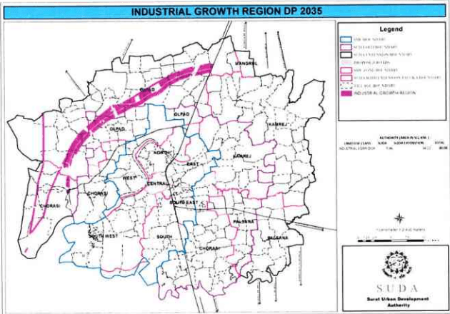
MT of cargo by the year 2030. In order to ensure that Hazira port is connected to the rest of the country, it is essential to have a strong dedicated network for transportation and communication. The evacuation of this huge volume of cargo is contingent only upon Hazira Port is connected to the network of Indian railway and the DFC project under implementation otherwise it will choke the roads around Surat city. SUDA has conceived a plan to develop industrial growth region of about 30 km long, having 1.445 km width from Hazira to the existing BG Delhi Mumbai railway line near Gotham admeasuring about 40 sq.km.
On the request of the Gujarat Maritime Board and considering the demand of the Hazira Industrial Association, this industrial growth region has been proposed in the Development Plan - 2035 of SUDA in which following cross-section is suggested subject to the recommendation by the experts who may be engaged by the SPV to be formed exclusively for this game changer project.
It is proposed to develop this region SIGR, by mechanism of Town Planning Scheme under the provisions of Gujarat Town Planning and Urban Development Act, 1976. For expedient implementation of this project, it is proposed to form a SPV which can act as Development Authority under the provisions of the Gujarat Town Planning and Urban Development Act, 1976 and can prepare the TP Scheme and allot the Final Plots for the specific purpose of residential, commercial, Logistics and Industries. Roads and Railway network can be proposed for the balanced development of this region as well as the surrounding areas. Hazira rail and road project is being developed by Govt. of Gujarat through GMB and GIDC's equity participation under non Government railway model in Hazira Infrastructure Private Limited (HIPL).
Figure 65: Industrial Growth Region- DP 2035
SURAT URBAN DEVELOPMENT AUTHORITY | Page | 194
C C C C C C C C C C C C C C C C C C C C C C C C C C C C C C C C C C C C C C C C C C C C C C C C C C C C C C C C C C C C C C C C C C C C C C C C C C C C C C C C C C C C C C C C C C
2017
The typical cross-section of this Industrial Growth Region could be as shown in the tablebelow:
Table 134cross-section of this Industrial Growth Region
Sr. No.
Proposed Land-use
Width
1
Utility Corridor
250 m
2
Railway Land
30 m
3
Industrial Zone
500 m
4
Part of Regional Ring Road
120 m
5
Logistics Zone
200 m
6
Road
45 m
7
Proposed Residential Zone
300 m
Total Width of the Corridor
1445 m
The development permission shall be given in this zone once the TP scheme is framed under the provisions of the Gujarat Town Planning and Urban Development Act, 1976.
Total area proposed under Industrial Growth Region zone is 40 sq.km., which is 5.09% of the total urbanised area proposed in DP 2035.
19.11.4Commercial Zone
Surat being the second largest city of Gujarat after Ahmedabad and having proximity to the Metro city of mumbai, lot of trade and commerce activities are happening in the Surat city. Considering the vision of preparing this Development Plan for SUDA to be growth engine of South Gujarat region, dedicated commercial zone shall help in increasing the commercial activity in Surat. About 8 sq.km. of commercial zone was proposed in the DP 2004. New commercial zone has been proposed in Chaltan village near the National Highway-8, which has potential to develop as a commercial centre for APMC. Commercial zone has also been proposed in the Surat Industrial Growth Region near the junction of 120 m Regional Ring and 90 m Radial Roads in Kareli, Masma and Narthan and their adjacent villages. The commercial zone proposed in the Kathor Development Plan which is now included in the SUDA area, is proposed to be continued as commercial zone since it is in vicinity to the National Highway-8.
Total area proposed under Commercial zone(including DP 2004 proposal) is 12 sq.km., which is 1.50% of the total urbanised area proposed in DP 2035.
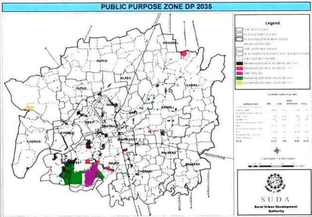
19.11.5Public Purpose
As per provisions of section 12(2) of the Act, the draft development plan shall provide for all or any of the following public purposes:
SURAT URBAN DEVELOPMENT AUTHORITY |
Page
a) proposals for the reservation of land for public purposes, such as schools, colleges, and other educational institutions, medical and public health institutions, markets, social welfare and cultural institutions, theatres and places for public entertainment, public assembly, museums, art galleries, religious buildings, play-grounds, stadium, open spaces, dairies;
b) transport and communications, such as roads, highways, railways, and airport, including their extension and development;
c) proposals for water supply, drainage, sewage disposal, other public utility amenities and services including supply of electricity and gas;
d) reservation of land for community facilities and services;
e) proposals for designation of sites for service industries, industrial estates and any other industrial development on an extensive scale;
f) proposals for flood control and prevention of river pollution;
g) proposals for the reservation of land for the purpose of Union, any State, local authority or any other authority or body established by or under any law for the time being in force.
It is necessary for the performance of statutory functions to take private as well as Government land for public use as the claim of the whole community is always superior and public necessity is greater than private interest and claim of an individual.
It is the duty vested in the Area Development Authority and it is the duty vested in the State Government to envisage all the future need of the society and of proper and systematic development of the area. If colleges or residential units are allowed to be constructed on the land upon which sewage treatment plant is necessary today, it cannot be removed in future, when there will be actual need for sewage treatment plant. All the necessary provisions ought to be made in advance for the subjects referred to in Section 12 of the Act so that whenever actual development is to be carried out either for constructing schools, colleges, gardens, medical and public health institutions, markets, places for public entertainment or construction for water supply, drainage or sewage treatment plant etc., it may not lead to a situation that no such development can ever be carried out. Therefore, there is need for reservation of the land for the public purpose as contemplated in the Act.
19.11.7Traffic and Transportation Zone
In the light of the present traffic and transportation issues and in view of the transportation needs of this rapidly growing Surat city and the adjoining other developed areas, there is a pressing need to devise suitable transportation plan for the whole SUDA area which should have the integration with the other development areas outside the SUDA boundary. The transportation system for the city needs to be planned in a comprehensive manner, both for the passenger and goods traffic. The recommendations of the Comprehensive Mobility Plan made for SMC area as part of City Development Plan has been given due consideration for framing the proposals.
Lack of efficient public transportation system, parking issues, etc. have been taken care of while framing the proposals. Hierarchy of road system has been properly established for the efficient, safe, sustainable, affordable and multi-modal public transportation system.
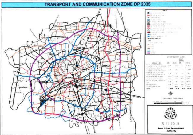
A high quality, well connected and integrated transportation network is essential to ensure healthy growth, thriving economy and high liveability standard for a city. To avoid traffic congestion problems in future and allow easy movement of goods and people, a comprehensive road network comprising of Rings and Radials has been proposed in the Development Plan 2035.
A 90 m wide Outer Ring Road around the existing city boundary has already been proposed. New Regional Ring Road of 120 m width and 116 km length is proposed in the SUDA area. This Ring will act as a gateway for traffic towards Mumbai and Ahmedabad. Some part of this 120 m wide road has also been proposed parallel to the National Highway-8 and the proposed Expressway. This 120 m
SURAT URBAN DEVELOPMENT AUTHORITY |
Page
road can be projected towards Bhruch-Ankleshwar Urban Development Authority in the north and towards Navsari Urban Development Authority in the south, which can extend up to Mumbai in future. Another 60 m wide Ring is proposed between 90 m and 120 m wide Ring Roads so as to accommodate the proposed residential zone. The part of this 60 m road is also proposed parallel to the national Highway 8 so that in case of emergency, this can act as an alternative path for going towards Bharuch, Ankleshwar in North and Navsari, Valsad, Mumbai in South.
All three ring roads are connected to the growth nodes and other major city centres through a network of major Radials of 90 m, 60 m and 45 m width. A combination of Rings and Radials is planned in such a way that everyone will have an access to one of these major roads from anywhere in the region at proximity of 3-4 km. 7 radials of 90 m width have been proposed in the SUDA area so as to have easy access from the adjoining area. 13 radial roads of 60 m width have been proposed. Similarly, 5 radial roads of 45 m width have been proposed.
19.11.6Recreational Zone
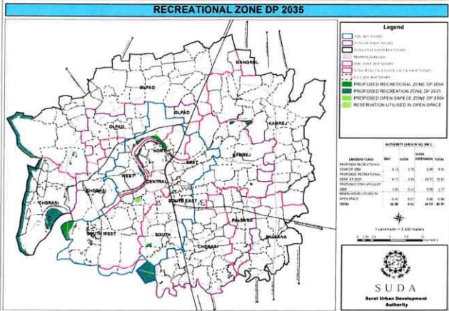
Recreational spaces are indispensable part of any urban area. The most liveable places to live are those where there are equal opportunities to live, work and play. Open spaces, Parks and Gardens play a very significant role in the landscape of the city. They are important input for generating quality of life that people value and enjoy in the city. The land around existing Talavs are proposed for Gardens and Recreational uses. Garden and open spaces at the neighbourhood level can be obtained in the TP schemes. Considering the large area and future population of SUDA region, total 46 sq.km. of recreational spaces are proposed in DP 2035 as compared to 12 sq.km. proposed in DP 2004. The major portion of recreational spaces are proposed on southern part of SUDA in the Gabheni village on the Government Land.
SURAT URBAN DEVELOPMENT AUTHORITY | Page |
C C C C C C C C C C C C C C C C C C C C C C C C C C C C C C C C C C C C C C C C C C C C C C C C C C C C C C C C C C C C C C C C C C C C C C C C C C C C C C C C C C C C C C C C C C C C C C C C C C C C C C C C C C C C C C C C C C C C C
2017
Figure 67: Recreational Zone Proposals- DP 2035
In the last 3 decades, the population in SMC area has recorded a decadal growth rate of more than 62%, 76% and 55% during 1981-91, 1991-2001 and 2001-2011 respectively. Development Plan of 2004 has anticipated the population of only 42 lakhss by 2011 for SUDA area. The actual population of SUDA area as per the last census 2011 is more than 49 lakhss much beyond the population projected in the 2004 Development Plan. Public facilities are necessary to be provided for the increasing population.
It is also pertinent to note that the State Government has extended the development area of SUDA from about 715 km² to about 1351 km² by adding another 100 villages having population of about 2.80 lakhss as per 2011 census by the notification of 9.12.2015 and 18.12.2015. Based on the past trend of population growth rate and the required planning intervention of the urban areas the
SURAT URBAN DEVELOPMENT AUTHORITY
C C C C C C C C C C C C C C C C C C C C C C C C C C C C C C C C C C C C C C C C C C C C C C C C C C C C C C C C C C C C C C C C C C C C C C C C C C C C C C C C C C C C C C C C C C
DEVELOPMENT PLAN 2035
2017
population of SUDA area for the target year of 2035 has been projected to be 110 lakhss. It means additional 60 lakhs people shall be living in SUDA area. Projects like, Expressway from Ahmadabad to Mumbai, DFC, High Speed Train, Bullet Train, Metro, DREAM City project, setting up of premier institutions / Universities, etc. is going to influence the Surat in a big way during the plan period of 2015-2035.
Moreover, the highly developed industrial pocket of Hazira Notified Area is also included in the new SUDA limits for which the Development Plan has now to be prepared. Hazira is one of the major ports of India. Development of Hazira having concentration of various large scale industries, has lot of implications on the planning proposals of the SUDA area. The existing industrial portfolio of Hazira includes industrial activities such as petrochemicals, fertilizers, heavy engineering, steel, energy and port related activities. More than 20 large and medium companies are located in Hazira, including KRIBHCO, ONGC, IOC, IPCL, BPCL, CAIRN ENERGY, NTPC, SHELL, GPCL, RELIANCE INDUSTRIES, L & T, ADANI Infrastructure, ESSAR, etc. Large industrial units are functioning in the Hazira area for which necessary infrastructure and planning inputs are required along with the comprehensive disaster management plan. Large scale movement of hazardous goods is also taking place to and fro from Hazira to different states through newly extended SUDA area. Moreover, Kathor development area, Sachin (Census Town), Kansad, Kadodara, Olpad, Sayan (Census Town), Amboli (Census Town), Kamrej, etc. are acting as magnet for the economic activities.
The need has arisen for reserving the land in the DP of SUDA for the various public purposes mentioned under section 12(2) of the Act for catering to the additional population and to satisfy the planning requirement.
SVNIT, being the technical institute of repute in Surat, SUDA took the expertise of SVNIT in analyzing the public purposes plots proposed in the Development Plan of 2004 and suggesting public purpose plots location to be reserved in this Development Plan - 2035 looking to the population growth rate and development happened and going to happen within the target year of 2035 in terms of its use, spatial extent and its location. Unique culture of the urban area as well as regional developments and national development policies were kept in mind for proposals.
SVNIT submitted the report in April 2016 and accordingly, the public purpose land are reserved in the SMC, Old SUDA and New SUDA area as per the provisions of section 12(2) of the Act, for various public purposes for acquiring agencies like SMC, SUDA, GHB, Custom department, R&B, GSRTC, Airport Authority, P & T, etc.
Under the provisions of the Act, the reserved land has to be acquired by consent, agreement or under the provisions of the Right to Fair Compensation and Transparency in Land Acquisition, Rehabilitation and Resettlement Act, 2013.
The Public Purpose zone proposed in DP 2004 has been continued in DP 2035.
Historical monuments, Government Buildings, etc. have been included in the Public Purpose zone.
About 36.54 sq.km. of the urbanized land has been proposed under reservation in the DP 2035. The list of reservation proposed in DP 2035 is given in Annexure-7 of this report. (removed)
Page
Total area proposed under Public Purpose zone(including DP 2004 proposal) is 63 sq.km., which is 8% of the total urbanised area proposed in DP 2035.
Figure 66: Public Purpose Zone Proposals- DP 2035
Total length of 120 m road proposed in SUDA area is 116 km, 90 m wide roads are of 140 km. 60 m wide roads have total length of 360 km, whereas 45 m wide roads have length of about 301 km. Thus the total major roads proposed in DP 2035, have cumulative length of 917 km. This road network will provide for smooth movement for public and goods traffic. Total road length proposed in the DP 2035 is more than 2200 km.
18 m wide road has been proposed parallel to the 90 m ORR on the periphery of 500 m residential zone. Wherever possible considering the existing land use and the embankment, the roads have been proposed along the Tapi river. Roads of appropriate width have also been proposed along the Khadis so that the Khadis can be protected and it can properly serviced as and when required.
It is proposed to provide ring road around each and every village, and these rings have been interconnected by network of 18 m roads. This will improve the movement of goods and traffic within the non- urban areas and help improve their economy.
DREAM CITY PROJECT is proposed in Khajod area having access from 90 m ORR. The activities proposed in the DREAM city will generate huge traffic volume. Moreover, the construction of Ubharat bridge in future will also add to the traffic volume on the 90 m ORR. Hazira now being included in the SUDA area- having huge volume of goods movement, there is a need to increase road width between the Khajod and Ichchapor junctions. The design of these two junction needs to be prepared by the traffic and transportation experts. Accordingly, the part of 90 m ORRT between these two junctions has been widened to 120 m width.
Vadodara- Mumbai Expressway is proposed to be passing through the newly extended area of SUDA. Since the exact alignment of this proposed Expressway is yet to be made available, it is proposed to have corridor of 500 m width along the roughly proposed alignment of the Expressway. This corridor will help in implementation of the Expressway of sufficient Right of Way(RoW). No development permission shall be given in this corridor till the RoW of the proposed Expressway is final decided by the concerned authority. Once the RoW is finalised, the rest of the land proposed in this corridor shall be used for purposes specified in the Agriculture zone.
The alignment of Dedicated Freight Corridor from Tapi river towards Dindoli has been marked in the Development Plan 2035 as per the alignment obtained from the concerned agency. The alignment
C C C C C C C C C C C C C C C C C C C C C C C C C C C C C C C C C C C C C C C C C C C C C C C C C C C C C C C C C C C C C C C C C C C C C C C C C C C C C C C C C C C C C C C C C C C C
2017
from Tapi towards Gothan was not available, hence tentative alignment from Tapi towards Gothan has been proposed in the land use plan. This will be corrected if made available by the concerned department before the submission of Draft DP 2035 under section 16 of the Act.
Micro level road network shall be prepared by virtue of Town Planning schemes. New railway network from Hazira to Gothan can be part of the SIGR. New bridges across Tapi river as suggested in the Comprehensive Mobility Plan(CMP) can be undertaken by SMC as and when the need arises during the plan period subject to the alignment suggested by the expert group. The list of proposed bridge in CMP is given below:
Table 135New bridges proposed across Tapi river the Comprehensive Mobility Plan
Sr. No.
Description
Carriageway width (m)
lanes
Length (m)
1
Utran-kapodara
15
6
1091
2
Third ring road(Nr. Varachha)
22
6
825
3
Ved-variyav
22
6
760
4
Dabholi-Jahangirpura
15
4
1059
5
Dhastipura- Jilani complex
15
4
1132
6
Athwa-adajan
15
4
1233
7
Pal-Umra
22
6
1780
8
Piplod-Bhata
7.5
2
600
Railway Station zone proposed in DP 2004 is continued in DP 2035.
|201
DEVELOPMENT PLAN 2035 | 2017
Figure 68: Traffic and Transport Zone- DP 2035
19.11.8 Institutional Zone
DREAM City project is being developed in the Khajod area. To supplement this project, it is proposed to have institutional zone in Sarsana, Jiav and Sonari villages in the SMC area near to the DREAM City project and having access from the 90 m ORR.
Total area proposed under Institutional zone is 6.1 sq.km.