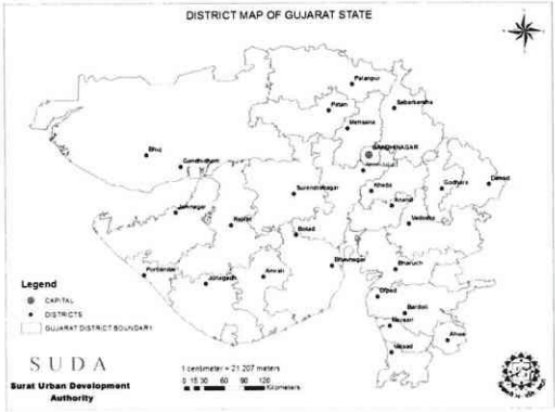
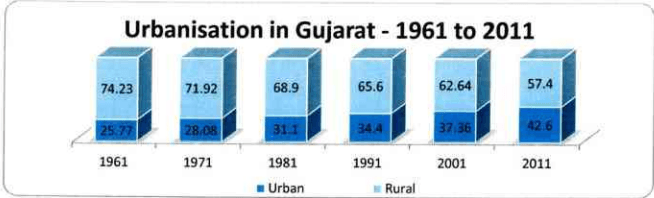
Urbanization in Gujarat has been on the rise ever since Gujarat was declared as a separate state in 1960, about 55 years ago. As per 1961 census, only 25.77% of the population was living in the urban areas of Gujarat which rose to 42.6% as per the recent census of 2011. Only two states, Tamilnadu (46%) and Maharashtra (45%) are more urbanized than Gujarat.
Figure 1: District Map of Gujarat state
About 75% of the total urban population of the State is living in the 8 Municipal Corporations. Surat Municipal Corporation (SMC from here on) is the second largest Municipal Corporation in the State after Ahmedabad.
Page | 2
C C C C C C C C C C C C C C C C C C C C C C C C C C C C C C C C C C C C C C C C C C C C C C C C C C C C C C C C C C C C C C C C C C C C C C C C C C C C C C C C C C C C C C C C C
2017
Figure 2: Urbanization in Gujarat from 1961 to 2011
Table 1Population of 8 cities (municipal corporation limit) of Gujarat-2011
Sr.No.
Municipal Corporation
Population
1
Ahmedabad
55,70,585
2
Surat
44,67,797
3
Vadodara
16,66,703
4
Rajkot
12,86,995
5
Bhavnagar
5,93,768
6
Jamnagar
5,29,308
7
Junagadh
3,20,250
8
Gandhinagar
2,92,752
Total
1,47,28,158 (Total urban population of the state 2,57,45,083)(57% of the total urban population of the State)
Chapter 1Introduction
Urbanisation is one of the most glaring realities of the 21 st century. All over the world, people are moving towards the cities. The bright lights of the cities, the perception that cities give greater opportunities and the desire to be at the heart of a ‘fast life’ is drawing people to cities. India is home to some of the world’s largest cities.
Urbanisation levels in India are increasing. From 28.1% of the population in 2001, we now have 31.16% of the population living in urban areas. The urbanisation in India as elsewhere, has catapulted cities as the engines of national development, a source of employment. Urbanisation is unequivocal, hence it is better we accept it as an opportunity. We have to strike a balance between the urban and non-urban areas that will take nation to further heights of progress in the 21 st century.
The state of Gujarat is not untouched by the phenomena of fast urbanisation. State is accelerating towards the process of urbanisation and modernisation due the fast growing economy of the State. The rapid pace of industrialisation during the past five decades in Gujarat is one of the prime factors contributing to urban growth. With the total population of 6.03 crores ( 10th most populous Indian state), the urban population has risen from 37% in 2001 to 43% in 2011, making it one of the fastest growing urbanized states.
Diamond city Surat's population grew from 2.8 million in 2001 to 4.5 million in 2011 — a phenomenal rise of 58.68%. Surat is Gujarat's 2nd most popular city, India's 8th most popular city. It is the 73rd largest urban area in the world. Surat ranks 4th fastest growing city in a global study of fastest developing cities conducted by The City Mayors Foundation, an international think tank on urban affairs. In fact, it is the fastest growing Indian city in terms of economic prosperity. Surat gained fame and recognition for being the '3rd Cleanest City' in India in 2011, awarded by INTACH. In 2013 Surat was conferred with two awards 'Best Urban City of India' and 'Best City to Live in India' constituted by Annual Survey of India's City-Systems (ASICS). UK-based charity, The Ecological Sequestration Trust (TEST) in 2013, has selected Surat as one of the three cities in the world, to be developed as 'Global Eco-cities'.
Backed by a dynamic team of officials and with the unwavering support of the people, Surat Urban Development Authority (hereinafter referred to as "SUDA") - is all set to take top class facilities to the villages so that both urban and rural areas can effectively contribute in our quest for sustainable and inclusive development of an important industrial hub and commercial centre of the country today.
The preparation of 'Development Plan 2035' was initiated in 2013. Based on the primary and secondary data available, the Status Survey Report was prepared for the old SUDA boundary comprising of SMC and 95 villages admeasuring 715 sq.km. Before this draft Development Plan could be submitted under section 9, the State Government in Urban Development and urban Housing Department by the notification dt. 9.12.2015 and 18.12.2015 extended the limits of SUDA boundary by adding another surrounding 100 villages. This increased the SUDA's jurisdiction to 1351 sq.km.
Page | 1
Since the status survey report of SMC area and 95 villages was already prepared, a separate chapter for additional 100 villages has been added at the end of this in chapter 7.
It is also necessary to mention that the State Government has framed The Gujarat Metropolitan Planning Committees Act, 2008 (Guj. 18 of 2008) and has also come into force. By the notification dated 11/03/2016, the Surat Metropolitan area has been declared under the said Act, 2008 which includes the SMC and Sachin Municipality area. The Metropolitan Committee for Surat was also constituted by the notification of the State Government dt. 11/03/2016 except for the elected members. The Draft Development Plan to be framed under the provisions of the Gujarat Metropolitan Planning Committees Act, 2008, is not in place as on today. Thus, the Draft Development Plan – 2035 of SUDA which is prepared under the provisions of the Gujarat Town Planning and Urban Development Act, 1976 is being submitted to State Government under section 9 and is to be published under section 13 of this Act.
1.2Historical Background of Surat
Surat - an important industrial hub and commercial centre of the country today boasts of a great historical and cultural heritage. The city of Surat has glorious history that dates back to 300 BC. The history of Surat takes us back to the epic age of Mahabharata and Ramayana. According to mythological beliefs, Lord Krishna stopped in the city during his journey from Mathura to Dwarka. According to The Editors of Encyclopaedia Britannica (Last Updated 13.12.2013), the great explorer Hiuen Tsang referred the Surat City as 'Sowrata' and described it as a business town on the shore of Arabian Sea near Gujarat. The Brahmin Pundits of the 13th century called the city as 'Suryapur'.
The city is believed to have been founded by a Brahmin named Gopi, who built the Gopi Tank (water reservoir) in 1516 and named the area 'Surajpur' or 'Suryapur'. He developed and improved the city with the establishment of place called 'Gopipura'. During this period Surat was described as city of great trade. The city was divided into two parts, old and new. The old city pattern developed with administrative centre at Chowk on bank of river Tapi. Trade and business were concentrated in
Chowk bazaar and Mulla chowk. The inner wall city was mostly developed as an administrative centre and as a specialize market.
In 1520, it was named 'Surat'. It was plundered by Muslims in the 12th and 15th centuries. In 16th century, Surat become a victim of various raids. In 1514 the Portuguese traveller Duarte Barbosa described Surat as a leading port. The Portuguese raided Rander and Surat between 1530 and 1535
Page |3
and burnt the port. On account of these raids, King Akbar build the fort of Surat in 1540-46; evidence of which can be found even today. Surat regained its prosperity as a modern city during the later part of the sixteenth century. The Surat Port was considered important by the European traders. The British and the Portuguese waged battles against each other to gain supreme control over the trading route. The French and the Dutch also arrived in the city with merchandising objectives. In past this was a glorious port with ships of more than 84 countries anchored in its harbour at any time. Surat thereafter became the emporium of India, exporting cloth and gold. Its major industries were textile manufacture and shipbuilding. The British established their first Indian factory (trading post) at Surat (1612). The city gradually declined throughout the 18th century. The British and Dutch both claimed control, but in 1800 its administration was passed to the British. It prospered again with the opening of India's railways. The ancient art of manufacturing fine muslin was revived, and Surat's cottons, silks, brocades, and objects of gold and silver became famous. The Tapi River grew into a major port for exports and as an important stopover for Muslim pilgrims bound for Mecca. By the early years of the 18 century, Surat had become a prosperous city with many weaving and spinning mills, textile and paper factories. Surat was also a flourishing centre for ship building activities. The whole coast of Tapi between current locations of Athwalines and Dumas was specially meant for ship builders. As the British developed Mumbai into a major port and administrative centre, Surat faced a severe blow and its ship building industry also declined. By the mid-19 century Surat was a stagnant city of 80,000 inhabitants. During the post-independence period, Surat has experienced considerable growth in industrial activities (especially textiles) along with trading activities. Concentration of these activities combined with residential developments has resulted in considerable expansion of the city limits. Modern Surat's main claim to fame is its position as the centre of diamond processing for the world diamond industry.
th
th
Surat is now considered one of the cleanest city of India and is also known by several other names like 'The Silk City', 'The Diamond City', 'The Green City', etc. It has the most vibrant present and an equally varied heritage of the past. Some of the important historical events related to the present SMC is tabulated below.
Table 2History of SMC
YEAR
EVENTS
1850
The Government enacted an Act for the development of the city. The Govt. was empowered to open a Department related to Municipality, on the request of the eminent citizens to effectuate the said Act. The Govt. appointed a committee called 'The Municipal Committee', which consisted of its officers and the eminent citizens to run the said Department
1852
The Municipality came into existence, legally, and its first meeting was held on 15.8.1852
1860
Erection of Surat Railway Station
1867
Municipality's Office was shifted to its existing building
1898
Water supply began through Municipal Water Works (1.1.1898)
1901
New Act of Municipality came into force
1946
The Municipality was re-established on 8thFebruary, 1946
1966
Conversion of Municipality into Municipal Corporation on 1stOctober, 1966
2017
1.3Location and Linkages
Surat city is located on the southern part of Gujarat state in the western India. It lies near the mouth of the Tapti River at the Gulf of Khambhat (Cambay). It is one of the most dynamic city of India with one of the fastest growth rate due to immigration from various part of Gujarat and other states of India. It is major urban centre on the Ahmedabad-Mumbai regional corridor. The city has grown on both the sides of river Tapi.
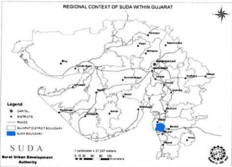
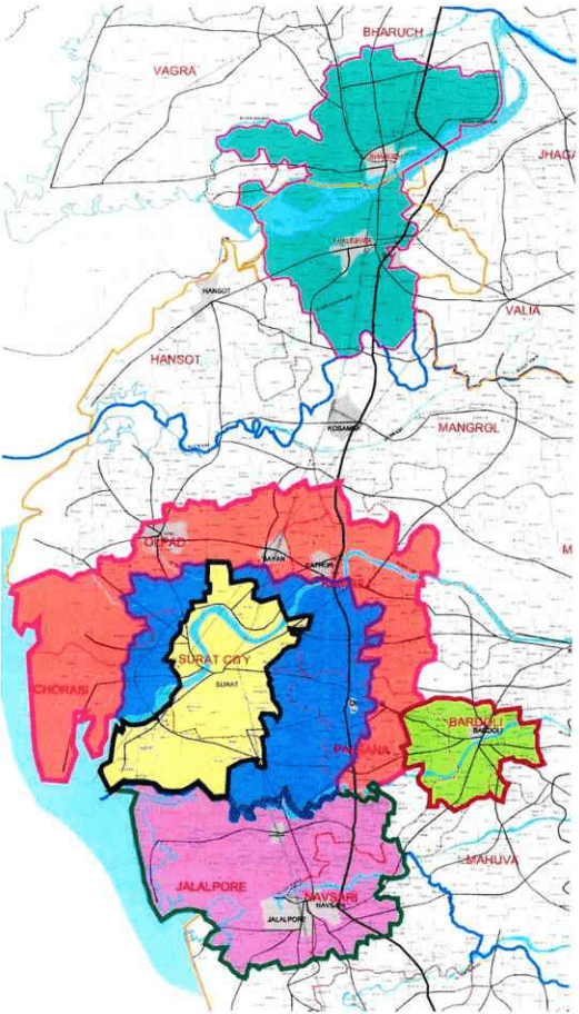
Regional setting of SUDA is shown in Figure - 3.
Figure 3: Regional context of SUDA within Gujarat
Surat is well connected by road and rail with major cities and town of the states as well as neighbouring states of Maharashtra and Madhya Pradesh. Surat is well connected to one of the busiest Delhi – Mumbai National Highway No. 8. It is located on the western side of this National Highway No. 8. It is approximately 300 km in south from the State capital Gandhinagar and
about 250 km from Ahmedabad. Vadodara is 170 km north of Surat. Mumbai is 260 km in south.
The spatial extent of SUDA admeasures 715 sq.km.
Main railway station in Surat is located near the city centre. For the air linkage there is domestic airport within the boundary of SUDA. Nearest international airports are at Ahmedabad and Mumbai almost equidistant at about 250 km.
The SUDA area is located between latitudes 21°03' and 21°19' North and longitudes 72°41' and 73°00' East which covers 715 sq.km. It is 13 m above mean sea level.
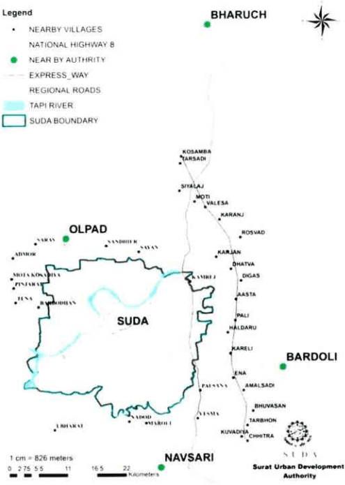
Within a periphery of 25 km from the boundary of SUDA, there are 3 urban centers Municipalities (namely Olpad in the north-western part, Navsari in the south-east and Bardoli to the west. The Bharuch Ankleshwar Urban Development Authority(BAUDA) is located in the northern direction.
Page | 5
Figure 4: Regional Context of SUDA with neighbouring Authorities
REGIONAL CONTEXT OF SUDA
2017
Figure 5: Regional map of various development authorities in south Gujarat
SURAT URBAN DEVELOPMENT AUTHORITY | Page 7
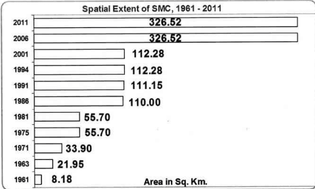
1.3.1 Spatial Extent & Growth of SMC
On 1 st October, 1966; when the Surat Municipality got the status of Municipal Corporation, it was only 8.18 sq.km. By 1971, the SMC area increased to 33.90 sq.km. After four years in 1975, the northern area at Ved, Dhabholi and Singhanpore were included in the SMC area, increasing the SMC area to 55.70 sq.km. After 11 years, in 1986 the SMC area was again expanded by including the area of Nana Varachha, Majura, Bhatar, Althan, Umra, Piplod, Jahangirabad, Jahangirpura. The area of SMC was 110 sq. km. in 1986. In 1994 its jurisdiction was extended to cover 112.28 sq.km. In 2006, the state Government in a major decision extended the jurisdiction of SMC by almost 3 times. Today, SMC cover an area of 326.52 sq.km.
Figure 6: Spatial Extent of SMC
When the SUDA was constituted in 1978, at that time its jurisdiction of 722 sq.km; including administrative boundary of SMC (admeasuring 55.70 sq.km.) and surrounding administrative boundaries of 148 Gram Panchayats (admeasuring 666.30 sq. km.). Later on, in 1979, the Delad village of Kamraej taluka was deleted from the list of villages included in the development area as this village was not in contiguity. So, the jurisdiction of SUDA was limited to 715 sq. km. The present jurisdiction of SUDA still extends to 715 sq.km. which includes the area under SMC and now surrounding 95 villages. Since the constitution of SUDA in 1978, the boundary of SUDA has not changed but the spatial extent of SMC has increased over a period of time from 1978 to 2011. The change in area of SMC and surrounding villages within the jurisdiction of SUDA since its constitution is shown in the Table below. At present in the SUDA area almost 45% is the jurisdiction of SMC.
Page | 8
- C C C C C C C C C C C C C C C C C C C C C C C C C C C C C C C C C C C C C C C C C C C C C C C C C C C C C C C C C C C C C C C C C C C C C C C C C C C C C C C C C C C C