7.2 Existing Land Use
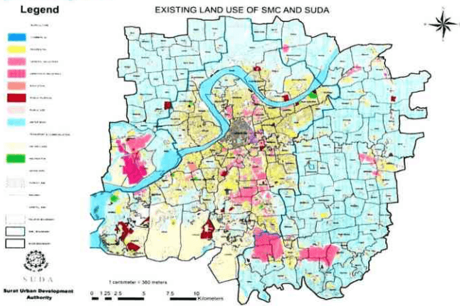
Between 1978 and 2004, the urbanized area has increased almost 3 times. The development that has taken place in the city over a period last 12 years is vivid. The existing land use prepared from the digitized base map is used to analyze the existing situation of development within SUDA Region. Development has mostly occurred in the SMC boundary. SUDA area excluding SMC area has experienced development in clusters with mostly residential and industrial development. The existing land-use as per ground situation 2014 is as shown below in the figure.
|54
2017
| Land Use | Existing - 2014 |
|---|---|
| Residential | 102.49 |
| Commercial | 4.66 |
| Industrial | 38.89 |
| Educational & Public Purpose | 13.6 |
| Garden & Recreational | 2.34 |
| Road, Transport and Communication | 35.31 |
| Urbanized Area | 197.29 |
| Non- urbanized Area | 517.71 |
| Total | 715 |
7.2.1 Residential Land Use
It includes housing of different types; detached, semi-detached and row houses, group housing and basis. The dominant use in the city is residential which accounts for near about 55% of the total urbanized area. The development in the city is taking place in the southern and north-eastern direction with planned and unplanned colonies. Area under residential use has increased drastically, from 2695.6 hectare in 1978 to 10,666 hectare in 2014, indicating the extent of the sprawl of the city. The percentage distribution of residential area is 58.54 % in 2011, which is on a slightly higher side then prescribed standards, which range from 40 % to 45 % as per UDPFI guidelines. High rise
SURAT URBAN DEVELOPMENT AUTHORITY |
|55
Page
development is coming near the University area while low rise development is coming towards Varachha road on SH-66. A serious challenge in the city is the rapid growth of slum squatters and settlements. Area under slums covers 1.8% of total area of SMC in 2007. There are 406 slums covering an area of 579.15 hectare of the total area of 32,651 hectare of SMC. Mainly these slums are near the medium industry in south and south-east side of the city.
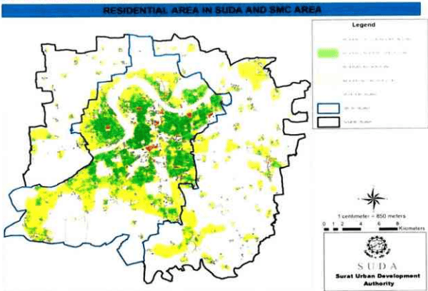
Figure 29: Residential Spill over
| Residential Land- use in SMC & SUDA Area | |
| Description | Area (sq.km.) |
| Land use zone in dp 2004 | 204 |
| Existing residential land use | 102.49 |
| Residential development outside zone | 18.51 |
Total residential area proposed is 204 sq.km. The developed residential area is 102.49 sq.km. out of which about 18.51 sq.km. is developed outside the proposed residential zone and can be considered as spill over.
2017
7.2.2 Commercial Land Use
Surat is one of the major trade centers in the region which is very efficiently connected by rail and road with the state capital Ahmadabad and other parts of the country. This has made Surat as an important trade and manufacturing centre of Gujarat. The concentration of commercial activity is in the walled city. Therefore being a densely populated area, it is having a problem of parking and informal activities. Other commercial activities are spread across the city. Commercial land use has increased almost three times in last three decades i.e. 141.3 hectare to 466 hectare, depicting importance of Surat as a trade centre.
7.2.3 Industrial Land Use
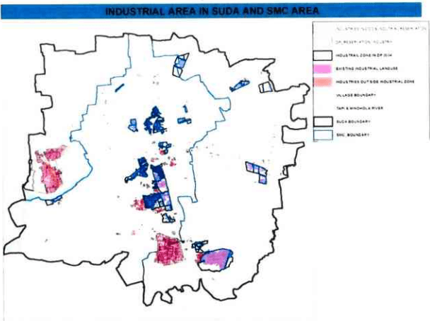
The growth of industries shows a steep increase from 1978 to 1995 and then a steady progress over the years till date. Industrial land use is almost seven times the commercial land use in the city. The percentage distribution of land under industries is reduced to 17.74% from 21.04% between 1995 and 2004 but the actual land use under industries has been increased to 3023.4 hectare in 2004 from 2784 hectare in 1995. In 2014 the industrial area is about 3945 hectare. Industries are mostly establishing themselves on the southern side on the road leading to Sachin and to the west on the road leading to Hazira.
| Industrial Land- use in SMC & SUDA Area | |
| Description | AREA (Sq. Km.) |
| Land use zone in dp 2004 | 31.1 |
| Existing industrial land use | 38.89 |
| Industries outside industrial zone | 11.21 |
SURAT URBAN DEVELOPMENT AUTHORITY |
Page
Figure 30: Industrial Spill over
7.2.4 Road Network and Transportation
The road network of Surat is primarily radial with all the regional roads leading out. Land under transportation land use is 9.16 % in 2004 covering an area of 1661.41 hectare, which has gone up to 3950 hectare by 2014 including the TP scheme and society level roads. This area covered by Road network and Transportation is saturated since 1995 showing no increase in 10 years.
7.3.5 Public and Semi Public
Areas allotted to public semi public use have shown reduction in percentage distribution. The area allotted under DP was 3350 hectare out of which the about 809 hectare has been developed in the existing land-use.