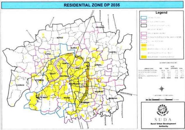
In DP 2004, 204 sq.km. of area including residential zone adjacent to 90 m Outer Ring Road(ORR) was proposed as residential zone. As per the existing land use, about 102 sq.km. residential zone has been consumed, while remaining 102 sq.km. residential zone as per DP 2004 is still left which can be used to cater future demand.
SURAT URBAN DEVELOPMENT AUTHORITY |
Page
|191
C C C C C C C C C C C C C C C C C C C C C C C C C C C C C C C C C C C C C C C C C C C C C C C C C C C C C C C C C C C C C C C C C C C C C C C C C C C C C C C C C C C C C C C C C C
DEVELOPMENT PLAN 2035
2017
According to census 2011 data, total population within SUDA boundary was around 50 lakhs. The population projected for 2035 is 110 lakhs. This means that there is requirement of planning for additional 60 lakhs population which is going to reside in SUDA by 2035. As per the UDPFI Guidelines, the population density for the residential use shall be 250 Per Hectare (PPH). If we want Gross Residential Density of 250 PPH for additional 60 lakhs population, we require 240 sq.km. of residential area. It means we have to propose residential zone to the tune of 342 sq.km. of total area.
While planning for the residential areas, the major factor considered is locating residential zones outside the 'flood-prone' areas. The special attention is given considering the history of frequent floods within SUDA, especially SMC boundaries. For this, a Digital Elevation Model (DEM) of entire SUDA area was prepared. Such model gives details about the area susceptible to inundation under various flood conditions. Once the DEM was ready, it was overlaid on the existing land-use map of SUDA and then location for the new residential areas to be proposed were decided accordingly.
The new residential zone to accommodate the additional population has been proposed considering the DEM. It is proposed to cover the area within SMC boundary for residential zone. After inclusion of land having potential for residential development within SMC area, the proposal for new residential zone has been made within the 90 m ORR. The rest f the residential area has been proposed on the outer side of the 90 m ORR, bounded by 60 m Ring Road. As mentioned earlier, Olpad and Kamrej growth nodes require control by zoning and therefore, these two nodes have been provided with residential zoning. Gamtals as proposed in 2004 DP have been kept intact and continued to be Gamtals. For the natural growth of the villages, the Village Extension Zone has been proposed up to 200 m and 300 m from the boundary of the existing Gamatls depending upon the population of the villages as per Census 2011. If the population is less than 5000, the Village Extension Zone should be 200 m from the boundary of the Gamtal, otherwise it should be 300 from existing Gamtal boundary. The Village Extension Zone shall not be applicable in case of deemed Gamtal.
The existing polluting industries within Surat city area are proposed to be shifted to another area. This area has been proposed for residential zone as per Development Plan, 2035. This residential zone shall be available for residential use only after the closure of the existing industries. Also, about 8.58 sq.km. of land has been proposed for reservation for different acquiring bodies like SMC, SUDA, GHB, PWD, etc. for the purpose of developing these lands for housing. The land under these reservations has been listed in the list of reservations. This area of reservation is not included in the proposed area under residential zone.
The Government of Gujarat has issued guidelines for construction of affordable housing within the development authority area. It is proposed to allow the affordable housing project as per the Government guidelines in any of the urbanized land use. The beneficiaries shall be as per the guidelines of the Government.
Total area proposed under Residential zone (including DP 2004 proposal) is 358 sq.km., which is 45.45% of the total urbanised area proposed in DP 2035.
Page
DEVELOPMENT PLAN 2035 2017
Figure 63: Residential Zone Proposals- DP 2035