To ensure the systematic and planned development of the Surat city and its surrounding areas, Surat Urban Development Authority(SUDA) was constituted on 30/01/1978 by Gujarat State Government under the provisions of the Gujarat Town Planning and Urban Development Act, 1976. Total area SUDA authority was 715 sq.km., including Surat Municipal Corporation and 148 surrounding villages. Between 1978 and 2015, the jurisdiction of SUDA was unchanged but the area of SUDA was increased to 1351 sq.km. by Gujarat State Government as per the notification No.GH/V/330 of 2015/UDA-102012-5026(3)-L dated 09/12/2015 and its corrigendum dated 18/12/2015. 100 more villages from 5 different talukas Olpad(40), Kamrej(37), Palsana(14), Choryasi(8) and Mangrol(1) have been made part of SUDA.
Kathor Grampanchayat was designated as area development authority under notification No.GHB-20-UDA-1177-646(2)-Q dated 30/01/1978. Also, an urban development authority was constituted for Hazira and surrounding areas under notification No.GHV/121/UDA-1181-5100-V dated 12/10/1985 which was later dissolved under notification No.GHV/106/1097/M/86/K dated 28/08/1997.
Under the notification No.GH/V/330 of 2015/UDA-102012-5026(3)-L dated 09/12/2015, both these areas were made part of SUDA and all the functions within these areas were transferred to SUDA. Development plans for these areas were prepared by respective authorities and are in force. However, after the inclusion of these areas within SUDA's jurisdiction, they will be considered as a part of SUDA's Development Plan for 2035.
7 (Hazira (C), Mora (C), Kamrej (K), Kathor (K), Olpad (O), Sayan (O) and Palsana (P)) of these 100 villages have population more than 10,000. Population wise summarisation is given below. There are 10 villages with population less than 500 and 6 of these are in Olpad taluka.
| Sr.No. | Name of Taluka | Total no. of towns in Taluka | Number of Towns in SUDA Jurisdiction | Names |
|---|---|---|---|---|
| 1 | Kamrej | 1 | 1 | Amboli |
| 2 | Palsana | 3 | 3 | Chalthan, Kadodara, Vareli |
| 3 | Olpad | 2 | 1 | Sayan |
| 4 | Choryasi | 10 | 8 | Limla, Mora, Kansad, Sachin,Ichchhapor, Pardi Kanade, Bharthana |
| 5 | Mangrol | 2 | 0 | - |
| 18 | 13 |
Page
| Taluka | Total no. of Villages | Total Population | No. of villages with population >10,000 | No. of villages with population 5,001-10,000 | No. of villages with population 1,001- 5,000 | No. of villages with population less than 1,000 |
|---|---|---|---|---|---|---|
| Kamrej | 37 | 87,730 | 2 | 1 | 24 | 10 |
| Palsana | 14 | 36,974 | 1 | 1 | 8 | 4 |
| Olpad | 40 | 96,022 | 2 | 2 | 22 | 14 |
| Choryasi | 8 | 51,964 | 2 | 1 | 5 | 0 |
| Mangrol | 1 | 7,765 | 0 | 1 | 0 | 0 |
| Total | 100 | 2,80,455 | 7 | 6 | 59 | 28 |
Source: census 2011
| Taluka | Total no. of Villages | Total Population | No. of villages with population >10,000 | No. of villages with population 5,001-10,000 | No. of villages with population 1,001-5,000 | No. of villages with population less than 1,000 |
|---|---|---|---|---|---|---|
| Kamrej | 17 | 71,409 | 3 | 1 | 10 | 3 |
| Palsana | 17 | 77,185 | 2 | 1 | 9 | 5 |
| Olpad | 17 | 19,657 | 0 | 0 | 8 | 9 |
| Choryasi | 44 | 1,69,053 | 4 | 6 | 20 | 14 |
| Total | 95 | 3,37,304 | 9 | 8 | 47 | 31 |
| Taluka | Total no. of Villages | Total Population | No. of villages with population >10,000 | No. of villages with population 5,001-10,000 | No. of villages with population 1,001-5,000 | No. of villages with population less than 1,000 |
|---|---|---|---|---|---|---|
| Kamrej | 54 | 1,59,139 | 5 | 2 | 34 | 13 |
| Palsana | 31 | 1,14,159 | 3 | 2 | 17 | 9 |
| Olpad | 57 | 1,15,679 | 2 | 2 | 30 | 23 |
| Choryasi | 52 | 2,21,017 | 6 | 7 | 25 | 14 |
| Mangrol | 1 | 7,765 | 0 | 1 | 0 | 0 |
| Total | 195 | 6,17,759 | 16 | 14 | 106 | 59 |
Page | 172
Figure 60: Existing Land-Use of Newly Added Villages in SUDA
DEVELOPMENT PLAN 2035
2017
17.1 Existing Land-use of Newly Added Villages
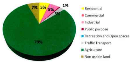
The existing land-use of newly added villages shown in the pie chart. Almost 80% of the area is under agricultural use. Other major uses are residential and industrial. The recreational and open space are 1% of total area which is well below the required standard.
17.2 Existing Infrastructure Analysis
17.2.1 Water Supply
Out of newly added 100 villages in SUDA jurisdiction, only 11 villages receive supply from Tapi river. The rest of the villages depend on ground water. These villages draw water from ground through bores and supply it to households by pipelines or use of hand pumps. There are few villages which depend on both surface and ground water sources. 25 of these villages are supplied water by GWSSB and most of the other villages are catered by respective Gram Panchayats.
| Sr.No. | Name of Taluka | Total Number of Villages | Water Supply | ||
| Source Tapi - Supply by Gwssb | Number of Villages Having Bores | Villages without Significant Data | |||
| 1 | Kamrej | 37 | 4 | 28 | 10 |
| 2 | Palsana | 14 | 1 | 14 | |
| 3 | Olpad | 40 | 4 | 31 | |
| 4 | Choryasi | 8 | 2 | 6 | |
| 5 | Mangrol | 1 | 0 | 1 | |
| Total | 100 | 11 | 79 | ||
Source: Data obtained from Talatis
17.2.2 Solid Waste Management
There is no scientific collection and treatment of municipal solid waste in these villages. In 16 villages, waste is collected from households. In all other villages, the waste is either burnt or disposed in open grounds or creeks by respective households.
SURAT URBAN DEVELOPMENT AUTHORITY |
Page
|173
| Sr.No. | Name of Taluka | Total Number of Villages | Solid Waste Management Collection | |
| Number of Villages Having Door-to-Door Collection | Number of Villages Disposing Individually | |||
| 1 | Kamrej | 37 | 11 | 26 |