2.1 Introduction
The Draft Development Plan 2035 is prepared with the objective to formulate a meaningful physical development plan to regulate and guide the urban growth in the development authority area in a planned and healthy manner as per the provisions indicated in the Gujarat Town Planning and Urban Development Act - 1976 and Gujarat Town Planning and Urban Development Rules - 1979. As per this Act, the Development plan shall be indicating the manner in which the use of land shall be regulated and the manner in which the development therein shall be carried out.
The exercise is taken based on the aim and objectives set out for the development plan for catering to the projected population of next 20 years i.e. up to 2035.
2.2 Process
Process of preparation of draft development plan involves generating the up-to-date land use map of the development area using revenue maps. This time the base map and the existing land use map of the SUDA area including the SMC area has been prepared using the recent satellite imageries (2012) with the help of GIS technology in 1:2000 scale. Land use survey was done to identify the directions of physical growth. After preparing the base map and undertaking the land use survey, ultimately a database shall be developed in GIS.
The preparation of the Draft Development Plan started with the assessment of the existing conditions and accounting for the potential resources and constraints. The assessment is done in terms of urbanization of the State, region and of the study area. Satellite imageries were used to assess the land cover and land use of the study area for studying the spatial extent of land under agricultural use, forest, water logged, built-up area \ use, open land etc. Assessment of existing housing stock, built area and social as well as physical infrastructure available to the people was undertaken. The extent of implementation of the development plan in force was also studied to know how much is achieved as per the plan proposal and where the market force has not allowed developing as per the proposals.
For the preparation of the Draft Development Plan, a number of study groups were formed for arriving at the proposals of the Draft Development Plan. All the background papers on technical aspects were put up before the Core Committee for their consideration and approval. The Core Committee also obtained advice and assistance of a number of other experts and officials and utilized their experience and knowledge in their respective fields. Following eight sub-committees were formed as shown in the Figure 8 below.
Page
Page | 15
2017
Figure 8: Committees for preparation Draft Development Plan 2035
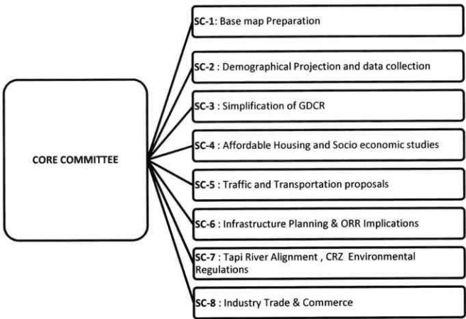
The assessment was made on the basis of secondary data collected from various agencies, on-the-spot surveys, studying the existing urban development policies of the State and on the basis of views expressed in the brain storming sessions of eight sub-committees of experts, formed by SUDA. The stakeholders were taken into confidence by organizing the workshops to know the issues at the grassroots level which are affecting the general public. Extensive public consultations were carried out at different stages of the Development Plan. The inputs from the consultations were studied and reviewed in detail, objectives to fulfil the vision are formulated based on the inferences from the stake holdings.
Conceptualization for planning the SUDA area was based on the above assessment. Proper distribution of the residential, industrial, commercial zone, as well as open and recreational spaces is to be suggested to evolve overall urban form for entire SUDA area for the year 2035.
The preparation of Draft Development Plan included the planning for the following:
A) Land Management
-
Land-use, for proper utilization of land for residential, commercial, industrial, institutional, recreation, transportation, agricultural & allied usages.
-
Housing, having proposals for supply of housing with infrastructure development and strategies for overall improvement.
-
Traffic and transportation, with long and short term strategies to take up development phase wise.
C D C C C C C C C C C C C C C C C C C C C C C C C C C C C C C C C C C C C C C C C C C C C C C C C C C C C C C C C C C C C C C C C C C C C C C C C C C C C C C C C C C C
2017
- Development control regulations, for proposed and anticipated development pattern considering the holistic and integrated growth.
B) Infrastructure Development
-
Water Resources Development and Drainage
-
Solid Waste Management
-
Assessment of social infrastructure including education, health, recreation and community facilities
-
Utility services for water supply, sewerage, drainage, electricity, etc.
C) Economic
-
Augmentation of financial resources
-
Investment plan
-
Estimates of revenue and resources with respect to implementation of different stages of Draft Development Plan
2.3 Detailed Methodology
Following is the detailed methodology adopted for the preparation of draft development plan.
2.3.1 Digital Base Map Creation
Preparation of base map is the most important task in preparation of any development plan. The remote sensing techniques were used for preparation of the base map of SUDA area. It involves:
-
0.6 m resolution Pan Sharpened Multi-spectral Quickbird satellite imageries of 2012 procured by SMC from NRSA Hyderabad and revenue base maps of all the villages coming under development plan area were obtained.
-
Carrying out DGPS Survey in all villages taking 2 points per village.
-
Rectification and geo referencing of the satellite imagery using DGPS control survey.
-
Geo-referencing, digitization, and mosaic of revenue maps. The revenue sheets were properly digitised and edge matched to form revenue villages and mosaic to form the Draft Development Plan Area.
-
Block No. level spatial database generation of the rectified digital revenue maps.
-
Surveys were carried out for existing land use data collection.
-
Interpretation of satellite imagery with ground verification to prepare the digital base map and existing land use map in GIS format.
-
Ground validation by field surveys: Validation to confirm the exiting land use
-
Quality checking.
-
Attachment of attribute data
-
The GIS database with revenue cadastral, imageries and image derived land use is developed on ArcGIS platform.
-
Survey of India topographic map is mainly used for the preparation of base map like transportation networks, water bodies location, etc. As a reference map (Software used ESRI-Arc GIS, AutoCAD, ERDAS).
Page |16
The geo-database is proposed to be developed on ArcGIS platform as a desktop application for viewing, querying and reporting of various spatial and non-spatial information, within the development authority area. The GIS database is to be prepared with mutually registered layers generated from cadastral maps, satellite image, field survey inputs, existing land use, proposed land use, etc.
2.3.2 Field Survey, Data Collection
- Review of extent of implementation of Revised Development Plan 2004 was done.
- The regional resource potentials of the hinterland was studied in detail in the context of major economic activities, broad land use, major transportation and communication network, tourism potentials, heritage preservation, regional level infrastructure facilities and broad environmental, ecological and conservation measures.
- The micro level study of land use and infrastructure developments including solid waste management.