This Section covers requirements of landscape planning and design with the view to promoting quality of outdoor built environment and protection of land and its resources.
Loading…
2.0 For the purpose of this Section, the following definitions shall apply.
2.1 Avenue — A wide road or pathway lined with trees on either sides.
2.2 Buffer — The use of landscape to curtail view, sound or dust with plants or earth berms, wall, or any such element.
2.3 Climber (Creeper/Vine) — A non-supporting plant, woody or herbaceous, which clings to a wall, trellis or other structures as it grows upward.
2.4 Columnar — A slender, upright plant form.
2.5 Contour — The form of the land, existing or proposed; a part of the topography, indicated by map lines at intervals as desired, to understand the landform clearly. The contour line though imaginary, indicates continuous elevation above mean sea level or an assumed datum line.
2.6 Contour Interval — The difference in elevation or the vertical distance measured between consecutive contour lines.
2.7 Egress — A way out, or exit.
2.8 Elevation — A contour line or notation of relative altitude, useful in plotting existing or proposed feature.
2.9 Exotic — A plant that is not native to the area in which it is planted.
5
2.10 Fencing — A barrier of plant or construction material used to set off the boundary of an area and to restrict visual or physical passage in or out of it.
2.11 Foliage — The collective leaves of a plant or plants.
2.12 Geo-textile — Any permeable textile (natural or synthetic) used with foundation, soil, rock, earth or any other geotechnical engineering-related material as an integral part of a human made project, structure or system.
2.13 Grade — The slope or lay of the land as indicated by a related series of elevations.
2.13.1 Natural Grade — Grade consisting of contours of unmodified natural landform.
2.13.2 Finished Grade — Grade accomplished after landscape features are installed and completed as shown on plan as proposed contours.
2.14 Gradient — The degree of slope of a pipe invert or road or land surface. The gradient is a measure of the slope height as related to its base. The slope is expressed in terms of percentage or ratio.
2.15 Grading — The cutting and/or filling of earth to establish smooth finish contours for a landscape construction project. Grading facilitates good drainage and sculpts land to suit the intent of landscape design.
2.16 Grasses — Plants that characteristically have joint stems, sheaths and narrow blades (leaves).
2.17 Groundcover — The planting material that forms a carpet of low height; these low-growing plants are usually installed as the final part of landscape construction.
2.18 Hard Landscape — Civil work component of landscape architecture such as pavement, walkways, roads, retaining walls, sculpture, street amenities, fountains and other built environment.
2.19 Hardy Plant — Plants that can withstand harsh temperature variations, pollution, dust, extreme soil conditions, and minimal water requirements and the likes. These plants have ability to remain dormant in such conditions and survive.
2.20 Hedge — Number of shrubs or trees (often similar species) planted closely together in a line. A hedge may be pruned to shape or allowed to grow to assume its natural shape.
2.21 Herb — An annual plant with a non-woody or fleshy structure. Certain herbs are highly useful for cooking or of high medicinal value.
2.22 Ingress — A way in, or entrance.
2.23 Invert — The low inside point of a pipe, culvert, or channel.
2.24 Kerb — A concrete or stone edging along a pathway or road often constructed with a channel to guide the flow of storm water and thereby serving dual purpose.
2.25 Mound — A small hill or bank of earth, developed as a characteristic feature in landscape.
2.26 Native — A plant indigenous to a particular locale.
2.27 Screen — A vegetative or constructed hedge or fence used to block wind, undesirable views, noise, glare and the like, as part of in landscape design; also known as ‘screen planting’ and ‘buffer plantation’.
2.28 Sediment — The product of erosion processes; the solid material, both mineral and organic, that is in suspension, is being transported or has been moved from its site of origin by air, water, gravity or ice.
2.29 Shrub — A woody plant of low to medium height, deciduous or evergreen, generally having many stem.
2.30 Soft Landscape — The natural elements in landscape design, such as plant materials and the soil itself.
2.31 Spot Elevation — In surveying and contour layout, an existing or proposed elevation noted as a dot on the plan.
2.32 Street/Outdoor Furniture — Items of furnishing in outdoor landscape.
2.33 Swale — A linear wide and shallow depression used to temporarily store, route or filter runoff. A swale may be grassed or lined.
2.34 Topsoil — The uppermost layer of the soil.
2.35 Transplanting — Moving a plant from its place of origin to another location.
2.36 Tree — A woody plant, generally taller than 2.00 m, with a well-distinguished trunk or trunks below the leaf crown.
2.36.1 Deciduous Tree — Tree that sheds all its leaves in autumn or in dry season.
2.36.2 Evergreen Tree — Tree that remains green for most part of the year and sheds leave slowly throughout the year.
2.37 Tree Grate — A metal grille, installed at the base of a tree otherwise surrounded by pavement, that allows the free passage of air, water, and nutrients to the tree root, but does not interfere with the foot traffic.
2.38 Tree/Plant Guard — The protection constructed around a tree to deter vandalism and help to prevent damage. It could be made of metal, bamboo or concrete or the like.
Any development project for which a permit or licence
is required, shall make application to the Authority on the prescribed form containing such particulars as the Authority may require. The form shall be signed by the owner and shall include the information given in 3.2 to 3.4. For various aspects of obtaining the permit, etc reference shall be made to Part 2 ‘Administration’.
The site plan to be submitted with the application for permit shall be drawn to a scale of not less than 1 in 500 for a site up to one hectare and not less than 1 in 1 000 for site more than 10 hectare. The following information shall be provided in addition to requirements for Site Plan as stated in Part 2 'Administration':
a) Existing and proposed topographic contours at interval not exceeding 50 cm and/or spot elevations as pertinent and Bench Mark of site with reference to the City Datum relative to the Mean Sea Level.
b) Limits of the 100 year flood plain and water surface elevation (when applicable).
c) Location of existing major physical features, such as railway track, drainage ways etc.
d) Location of service utilities adjacent to the project with relevant top and invert levels clearly indicated.
e) Point of egress and ingress including locations and width of road.
f) Fully dimensioned loading spaces and maneuvering areas.
g) Parking including, location, parking spaces, size and number, and typical parking space details for both handicapped and standard spaces.
h) Vehicular, bicycle, pedestrian and handicapped circulation clearly identified.
j) Detail for parking areas including type of lighting, material for paving, and security rooms, rest rooms; and type of directional signage etc.
k) Drainage system, proposed finish ground elevations and finish grades.
m) Location of proposed fire hydrant points.
n) Location and dimension of fire lanes.
p) Proposed lighting layout.
q) Landscape irrigation points and source of water.
r) Fences, walls, or vegetation for screening by type, material, height, location, and spacing.
s) Location of proposed street furniture.
t) Refuse container location, size, and access.
u) Landscape paving materials with location.
v) Location, type, size, and height of existing and proposed signage.
w) List of existing trees with botanical and common names and height of the tree (see 4.1.2 for plant material schedule).
x) Prior approvals.
Landscape plan and drawings shall consist of the plans and details as given in 3.3.1 to 3.3.4.
The grading plan to be submitted with the application for permit shall be drawn to a scale of not less than 1 in 500 for a site up to 10 hectare and not less than 1 in 1 000 for site more than 10 hectare (see also 6.2). The grading plan will include measures for soil and sedimentation control and also measures during construction to prevent soil erosion, and also water harvesting practices (see also 4 and 5).
The planting plan shall be drawn to a scale of not less than 1 in 200 for a site up to one hectare and not less than 1 in 500 for site more than 10 hectare with part plans at 1 in 200 of two of the design areas. Planting plan should include plant material schedule as shown in Table 1. The planting plan and landscape plan must show identical information to avoid conflict between both plans. The planting plan shall include the layouts as given below drawn to the scale:
a) Location of proposed trees, shrubs, ground covers and lawn area indicated clearly with appropriate symbols and legend.
b) The size of plant material indicated in the drawing should be shown as diameter of canopy for tree and spread for shrubs and ground cover. Two years growth will be considered as full maturity size for shrubs and ground covers and ten years growth will be considered for trees.
c) The Botanical name could be indicated as a symbol on the main drawing (for example Delonix regia as Dr). Plant names should to be tabulated in alphabetical order under heads Trees, Shrubs, Groundcovers, Climbers and Grass.
d) Functional attributes and growth pattern tabulation to be attached as Table 2, as an annex.
e) All existing vegetation shall be marked on the landscape plan and areas designated for
preservation of existing vegetation on site shall be demarcated clearly (see also 4.1.2).
f) A concept plan of scale not less than 1 in 1 000 indicating the intent of the design with respect to the functions for various parts of the scheme should be included.
| Tree No. | Code | Botanical Name | Common Name | Quantity |
|---|---|---|---|---|
| (1) | (2) | (3) | (4) | (5) |
4.0 Development projects involve disturbance to the existing soil conditions, removal of existing trees and overall change in the microclimate and drainage pattern. Measures to minimize hazardous effects should be put into effect as explained below.
Measures for the prevention of soil erosion, sediment control and management of storm water shall be implemented as given in 4.1.1 to 4.1.5.
Construction work and erosion control applications shall be scheduled and sequenced during dry weather periods when the potential for erosion is the lowest. Slope protection techniques to control erosion shall be used when construction during wet season is unavoidable. Sedimentation collection systems, drainage systems, and runoff diversion devices shall be installed before construction activity. The Landscape Architect/Architect/Engineer-in-charge shall monitor the site conditions and progress of work and schedule appropriate timing and sequencing of construction.
4.1.2.1 Protection of existing vegetation (including trees, shrubs, grasses and other plants) where possible, by preventing disturbance or damage to specified areas during construction is recommended. This practice minimizes the amount of bare soil exposed to erosive forces. All existing vegetation shall be marked on a site survey plan. A tree survey in prescribed format shall be
carried out as indicated in Table 3. The landscape plan should indicate trees, which have been preserved, and also those, which had to be transplanted or removed clearly differentiating between these three categories.
| Tree No. | Botanical Name | Common Name | Girth | Height | Spread | Condition |
|---|---|---|---|---|---|---|
| (1) | (2) | (3) | (4) | (5) | (6) | (7) |
4.1.2.2 Trees retained on the project site shall be protected during the construction period by following measures:
a) Damage to roots shall be prevented during trenching, placing backfill, driving or parking heavy equipment, dumping of trash, oil, paint, and other materials detrimental to plant health by restricting these activities to outside the area of the canopy of the tree.
b) Trees will not be used for support; their trunks shall not be damaged by cutting and carving or by nailing posters, advertisements or other material.
c) Lighting of fires or carrying out heat or gas emitting construction activity within the ground, covered by canopy of the tree shall not be permitted.
d) Young trees or saplings identified for preservation (height less than 2.00 m, 0.10 m trunk girth at 1.00 m height from finish ground, 2.00 m crown diameter) within the construction site have to be protected using tree guards of approved specification.
Existing drainage patterns through or into any preservation area shall not be modified unless specifically directed by the Landscape Architect/Architect/Engineer-in-charge.
f) Existing grades shall be maintained around existing vegetation and lowering or raising the levels around the vegetation is not allowed unless specifically directed by the Landscape Architect/Architect/Engineer-in-charge.
g) Maintenance activities shall be performed as needed to ensure that the vegetation remains healthy.
h) The preserved vegetated area shall be inspected by the Landscape Architect/ Architect/Engineer-in-charge at regular intervals so that they remain undisturbed. The
date of inspection, type of maintenance or restorative action followed shall be recorded in the logbook.
Measures shall be followed for collecting runoff from construction areas and material storage sites; diverting water flow away from such polluted areas, so that pollutants do not mix with storm water runoff from undisturbed areas.
Temporary drainage channels, perimeter dike/swale, etc shall be constructed to carry the pollutant-laden water directly to treatment device or facility. The plan shall indicate how the above is accomplished on site, well in advance of the commencing of the construction activity.
Topsoil removal and preservation shall be mandatory for development projects larger than 1.00 hectare. Topsoil shall be stripped to a depth of 200 mm from areas proposed to be occupied by buildings, roads, paved areas and external services. Topsoil is rich in organic content and is essential to establish new vegetation. It shall be stockpiled to a height of 400 mm in designated areas and shall be re-applied to site during plantation of the proposed vegetation. Topsoil shall be separated from sub-soil debris and stones larger than 50 mm diameter. The stored topsoil may be used as finished grade for planting areas.
Spill prevention and control plans shall be made, clearly stating measures to stop the source of the spill, to contain the spill, to dispose the contaminated material and hazardous wastes, and stating designation of personnel trained to prevent and control spills. Hazardous wastes include pesticides, paints, cleaners, petroleum products, fertilizers and solvents.
During construction soil becomes unconsolidated due to removal of stabilizing material such as vegetation and disturbance of stabilized existing grade resulting in loss of topsoil and also deposition in undesirable places. A soil erosion and sedimentation control plan to be prepared prior to construction. The soil erosion, sediment control and storm water practices should be considered whilst construction is proceeding, in accordance with 4.2.1 to 4.2.4.
A temporary dam or basin at the lowest point of the site has to be constructed for collecting, trapping and storing sediment produced by the construction activities, together with a flow detention facility for
reducing peak runoff rates. This would allow most of the sediments to settle before the runoff is directed towards the outfall.
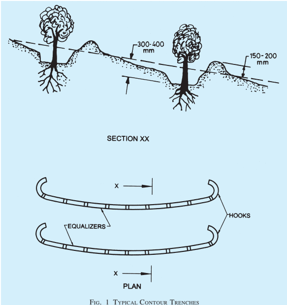
Contour trenching is an earth embankment or ridgeand-channel arrangement constructed parallel to the contours along the face of the slope at regular intervals on long and steep slopes (in sloping areas with slopes greater than 10 percent) (see Fig. 1). They are used for reducing runoff velocity, increasing the distance of overland runoff flow, and to hold moisture and minimize sediment loading of surface runoff. Vegetative cover of tree and native grasses in the channels may be planted to stabilize the slopes and reduce erosion.
Mulching shall be used with seeding and planting in steep slope areas (slopes greater than 33 percent) that are prone to heavy erosion. Netting or anchoring shall be used to hold it in place. Other surface runoff control measures like contour terracing to break up concentrated flows shall be installed prior to seeding and mulching. Materials such as straw, grass, grass hay and compost shall be placed on or incorporated into the soil surface. In addition to stabilizing soils, mulching will reduce the storm water runoff over an area. Together with seeding or planting, mulching aids plant growth by holding the seed, fertilizers and topsoil in place. It retains moisture and insulates the soil against extreme temperatures.
A deformed or non-deformed netlike polymeric material used with foundation, soil, rock, earth or any other geo-technical engineering-related material as an integral part of the human-made project structure or system, called geo-grids may be used as control measure. On filling with lightly compacted soil or fine aggregate, a monolithic structure is created providing an effective means of confinement for unconsolidated materials within the cells and preventing their movement even on steep slopes. If required the area can then be seeded to maintain ‘green’ environment. The junctions have a central opening through which water can permeate ensuring that organic material receives moisture for rapid growth.
The soil conservation, sediment control and storm water management practices as given in 5.1 to 5.3 shall be followed after construction is completed.
The vegetative measures shall include the following:
This includes the placement of topsoil or other suitable plant material over disturbed lands to provide suitable soil medium for vegetative growth. Topsoil laying shall involve replacing fertile topsoils that were stripped and stockpiled during earlier site development activities; the laid soil shall be stabilized before the next monsoon by planting grass, shrubs and trees.
The following guidelines shall apply to the placement of topsoil:
a) The existing or established grade of sub-soil should be maintained.
b) A pH of 6.0 to 7.5 and organic content of not less than 1.5 percent by mass is recommended for topsoil. Where pH is less than 6.0, lime shall be applied to adjust pH to 6.5 or higher up to 7.5. Any soils having soluble salt content greater than 500 parts per million shall not be used.
c) Prior to spreading the topsoil, the sub-grade shall be loosened to a depth of 50 mm to permit bonding. Topsoil shall be spread uniformly at a minimum compacted depth of 50 mm on grade of 1:3 or steeper slopes; a minimum depth of 100 mm on shallower slopes is essential. A depth of 300 mm is preferred on relatively flatter land.
The most effective way to prevent soil erosion, sedimentation and to stabilize disturbed and undisturbed land is through the provision of vegetative cover by effective planting practices. The foliage and roots of plants provide dust control and a reduction in erosion potential by increasing the infiltration, trapping sediment, stabilizing soil, and dissipating the energy of hard rain. Temporary seeding shall be used in areas disturbed after rough grading to provide soil protection until final cover is established. Permanent seeding/
planting is used in buffer areas, vegetated swales and steep slopes. The vegetative cover also increases the percolation of rain-water thereby increasing the ground water recharge.
The surface water flow is increased in urban areas due to predominance of hard surfaces. Storm water management techniques assure conservation of water thereby increasing the ground water recharge. Filters facilitate draining pollutants out from surface water runoff through straining before discharge into the drainage way. Rain-water harvesting and sullage recycle systems need to be implemented on all new constructions over 1 000 m2 in urban areas (see also Part 9 ‘Plumbing Services, Section 1 Water Supply, Drainage and Sanitation’).
5.2.1.1 Water harvesting refers to the collection and storage of rain-water and also harvesting surface and ground water, prevention of loss through evaporation and seepage, and other hydrological and engineering interventions aimed at conserving water.
a) Water harvesting recharges ground water and is an ideal solution to water problems in areas with inadequate water resources.
b) Increase in ground water aquifer level due to methods enhancing infiltration.
c) Mitigation of the effect of drought.
d) Reduction of storm water runoff into the public drainage system.
e) Reduction of flooding of the roads during monsoons.
f) Removal of pollutants and soil from the storm water runoff.
g) Reduction of soil erosion.
a) Recharge pits,
b) Recharge trenches,
c) Re-use of abandoned dug wells,
d) Re-use of abandoned hand pumps,
e) Recharge shafts,
f) Lateral shafts with bore wells, and
g) Spreading techniques like percolation ponds, check dams or gabion structures.
These may be as given in 5.2.2.1 and 5.2.2.2.
a) Infiltration trenches — An infiltration trench is a rock filled trench that receives storm water runoff. Storm water passes through a combination of pre-treatment measures, a grass swale and into the trench to be stored in void spaces and then infiltrates into the soil matrix.
b) Bio-filtration swale/grass swale — Biofiltration swales are vegetated channels with a slope similar to that of standard storm drain channels (less than 0.6 percent), but wider and shallower to maximize flow residence time and promote pollutant removal by filtration through the use of properly selected vegetation. It has to be designed to trap particulate pollutants (suspended solids and trace metals), promote infiltration and reduce the flow velocity of the storm water runoff. It shall be integrated with storm water system (see Fig. 2).
The following measures shall be followed for design of irrigation systems for landscape works:
a) Water conserving irrigation systems should differentiate between systems for different water use zones on the site. Supplementary irrigation sources should be used by means of appropriate water harvesting measures.
b) The irrigation system should be designed considering the prevailing wind direction, slope and proposed grade, type of soil, soil percolation, and the type of vegetation to be watered.
c) Spray irrigation to be designed to provide total head to head cover to avoid dry spots and spray on to paved areas and unplanted surfaces.
d) Spray irrigation is to be avoided in areas of width less than 3.00 m.
e) Sullage recycle systems are ideal for large housing complexes and residential colonies. Sullage (or water from kitchens and bathrooms) is treated and recycled for gardening and toilet flushing reducing fresh water requirement by 60 percent. Irrigation system should be designed keeping sullage recycle in view.
f) For requirements regarding, the volume of water for different kinds of landscapes, see Part 9 ‘Plumbing Services, Section 1 Water
Supply, Drainage and Sanitation’ may be referred.
The use of vegetation for controlling wind is widely recognized as an effective way of conserving soil and reducing erosion by wind. Vegetation may therefore be used for modifying the microclimate, by obstructing, guiding, deflecting or filtering wind current.
Vegetation areas designed to fulfill these general functions are usually classified as windbreakers and shelterbelts. Windbreaker is grown protective planting around gardens and orchards. Windbreakers generally consist of single or double row of trees. Shelterbelt provides an extensive barrier of trees with several rows of trees. Plant species are chosen with particular regard to their physical and growth characteristics, and their effectiveness in achieving the desired results. Both windbreakers and shelterbelts have considerable visual impact in the landscape in which they are situated, they therefore need to be designed so that they make a positive visual and aesthetic contribution to their environment.
Windbreakers and shelterbelts fulfill essential microclimatic functions in rural and urban environments. Benefits accruing from plantation of shelter planting may be as follows:
a) Reduction in wind velocity resulting in the arrest of movements of sand and soil particles.
b) Prevention of soil erosion.
c) Modification of micro-climate; moderation of change in air temperature.
d) Protection of crops from being blown by high winds.
e) Protection of livestock.
f) Reduction in evaporation of soil moisture. Increase in soil moisture content varies from 3 percent to 7.8 percent. Water loss due to evaporation is lessened.
g) Increase in soil moisture due to greater dewfall in sheltered areas has been found to be 200 percent higher than on exposed ground; heaviest dew fall is over a distance of 2 to 3 times the height of the shelterbelt.
h) Beneficial effect on growth of plants that are affected by high winds.
j) Extensive shelterbelts may also be used to augment the supply of fuel in rural areas.
k) The zone of influence of shelterbelt on crop
yield extends to a distance of 20 times the height of the belt, with the maximum effect being observed 10 times the height of the tree belt, on the leeward side.
Some of the basic functions of windbreaks and shelterbelts in arid and semi-arid areas are to conserve soil and reduce erosion by wind (see 7.3). The latter is a natural phenomenon in and lands having very little rainfall (125 mm-250 mm) and in areas adjoining a river, lake or sea. Wind erosion is a serious problem in areas where the ground is virtually bare and devoid of vegetation.
Factors which influence the degree and kind of wind erosion are as follows:
a) Features of wind — Speed, direction, temperature, humility, burden carried, etc.
b) Character of surface — Rough or smooth plant cover, obstruction, temperature, etc.
c) Topography — Flat, undulating broken, etc.
d) Character of soil — Texture, organic matter, moisture content, etc.
The principal method of reducing surface velocity of wind, upon which depends the abrasive and transportation capacity of wind, is by vegetation measures. Vegetation methods are found to be most effective in the form of windbreaks and shelterbelts. In aerodynamic terms, these provide protection as follows:
a) Sheltered zone on the leeward side extends to approximately 15-30 times the height of the belt.
b) A dense belt provides greater shelter immediately to leeward side but the sheltered area is not as extensive as when a more permeable zone of vegetation is provided.
c) Porosity is important in the effectiveness of shelterbelt and proper selection of tree species is necessary. Porosity near ground level is desirable.
d) Effectiveness of shelter planting depends more on height and permeability than on width. The width influences the general microclimate but above a certain minimum width, it does not effect greater reduction in wind velocity.
Protection obtained varies in relation to height (H) of shelterbelts, as given below:
| Distance | Wind Reduced by (in percent) |
|---|---|
| H | 90 |
| 2H | 75 |
| 5H | 50 |
| 10H | 20 |
This indicates that it is better to have several windbreaks 5H to 6H apart rather than large forest stands with wide open spaces in between.
A belt which rises and falls abruptly on windward and leeward sides is said to be more effective. Smaller trees and shrubs should occupy the inter-spaces between the tall tree.
NOTE — Some authorities maintain that triangular section of shelterbelt planting is more effective.
The depth of the shelterbelt should be approximately ten times its height. This is, however, only a thumb rule. Much lesser widths of 20 m to 30 m have also been found to be useful in particular situations; 15 m should be considered as minimum width.
Apart from factors such as climate, soil, fast rate of growth, one of the more significant considerations in choosing species for shelter planting is the possibility of a particular species serving the dual role of woodproduction (for fuel, fodder) as well as shelter.
Windbreaks usually consist of a single or double row of trees planted at 0.7 m to 1.5 m according to species. Normally, one year old trees are used. As the roots of tree extend for some distance beyond the rows in which they are planted, the same should be taken into account while planting windbreakers. The most common layout where shelter planting is part of an extensive planned programme, is that of tree belts arranged in a chessboard pattern, each field being-protected from every side. This pattern gives full protection to all the fields, provided that the right distance between the fields has been chosen. Efficient protection is achieved if belts are separated by a distance of not more than 20 times the height of the trees. A considerable mixture of species is recommended so as to compensate for different rates of growth and also to achieve variety in the form of crowns.
7.3.3.2 Within shelterbelts, close spacing of tree is the general practice. The recommended spacing for shrubs is 1 m and for tree such as Casuarina and Grevellia robusta (Silver Oak) 2.5 m. Spacing between rows should be 2.3 m to 3 m to enable mechanized cultivation. Five rows of tree and shrubs are considered necessary for protection.
Shelterbelts should be regarded as living groups of trees to be managed in perpetuity and the following shall be taken into consideration for management thereof:
a) Thinnings are limited to a strict minimum.
b) Cutting is done individually by single tree selection method.
c) Continuous cultivation may be required in areas with scanty rainfall.
d) If individual trees do not survive, they should be replaced immediately to avoid gaps in the vegetation belt. The shelterbelt should be protected from cattle, either by fencing or other means, specially in the early stages.
The location of shelterbelt may be related to local features such as public and private road networks, buildings, irrigation and water conservation works and methods soil management practice (contour bunding, contour cultivation etc). Careful choice of site will provide maximum protection to adjacent land and give shelter and shade.
The application of the concept of shelterbelts to landscape planning and design may be effective in the creation of landscape structure of very large developments at the regional scale, or townships or campuses. Shelterbelts can also be established in association with, or instead of road side planting. This itself creates a distinctive landscape pattern. The advantage of using native species in shelter planting are:
a) New development is merged into the existing landscape. The original character of the landscape is therefore not obtruded upon.
b) The shelterbelt is a component of land management (previous waste or barren land is conserved).
c) Additional habitat for wildlife are brought into existence.
a) For Dry and Arid Regions
Acacia auriculiformis (Australian Blackwood)
Ailanthus excelsa (Maharukh)
Albilzia lebbeck (Siris)
Azadiracta indica (Neem)
Casuarina equisetifolia (Beef-wood)
Dalbergia sissoo (Sisham)
Eugenia jambolana (Jamun)
Grevillea robusta (Silver oak)
Peltophorum ferrugineum (Cooper pod)
Tamarindus indica (Imli)
Pongamia glabra (Indian beech)
Tamarix articulata (Tamarisk)
b) For Coastal Area
Anacardium occidentale (Cashu)
Ailanthus malabarica (Alston)
Cassuarina equisetifolia (Beef-wood)
Pongamia glabra (Indian beech)
Sesbania aculeate (Sesban)
Thevetia peruvian (Yellow oleander)
Thespesia populnea (Indian Tulip)
Vitex negundo (Sephali)
8.3.1 Trees should be supplied with adequate protection as approved. After delivery, if planting is not to be carried out immediately, balled plants should be placed cheek to cheek and the ball covered with sand to prevent drying out. Bare rooted plants can be
heeled in by placing the roots in a prepared trench and covering them with earth which should be watered in to avoid air pockets round the roots.
Tree pits shall be dug a minimum of three weeks prior to backfilling. The pits shall be 1 200 mm in diameter and 1 200 mm deep. While digging the pits, the topsoil up to a depth of 300 mm may be kept aside, if found good (depending upon site conditions), and mixed with the rest of the soil. If the soil is bad below, it shall be replaced with the soil mixture as specified further herein. If the soil is normal it shall be mixed with manure; river sand shall be added to the soil if it is heavy.
The soil backfilled, watered through and gently pressed down, a day previous to planting, to make sure that it may not further settle down after planting. The soil shall be pressed down firmly by treading it down, leaving a shallow depression all round for watering.
No tree pits shall be dug until final tree positions have been pegged out for approval. Care shall be taken that the plant sapling when planted is not buried deeper than in the nursery, or in the pot. Planting should not be carried out in waterlogged soil.
Trees should be planted up to the original soil depth; the soil marks on the stem is an indication of this and it should be maintained on the finished level, allowing for setting of the soil after planting. All plastic and other imperishable containers should be removed before planting. Any broken or damaged roots should be cut back to sound growth.
The bottom of the planting pit should be covered with 50 mm to 75 mm of soil. Bare roots should be spread evenly in the planting pit; and small mound in the centre of the pits on which the roots are placed will aid an even spread. Soil should be placed around the roots, gently shaking the trees to allow soil particles to shift into the root system to ensure close contact with all roots and to prevent air pockets. Back fill soil should be firm as filling proceeds, layer by layer, care being taken to avoid damaging the roots.
Newly planted trees shall be held firmly although not rigidly by staking to prevent a pocket forming around the stem and newly formed fibrous roots being broken by mechanical pulling as the tree rocks.
The main methods of staking shall be:
a) A single vertical stake, 900 mm longer than
the clear stem of the tree, driven 600 mm to 900 mm into the soil.
b) Two stakes as above driven firmly on either side of the tree with cross-bar to which the stem is attached (suitable for small barerooted or balled material).
c) A single stake driven in at an angle 45o and leaning towards the prevailing wind, the stem just below the lowest branch being attached to the stake (suitable for small bare-rooted or balled material).
The end of stake should be pointed and the lower 1 m to 1.2 m should be coated with non-injurious wood preservative allowing at least 150 mm above ground level.
Each tree should be firmly secured to the stake so as to prevent excessive movement. Abrasion shall be avoided by using a buffer, rubber or hessian, between the tree and stake. The tree should be secured at a point just below its lowest branch, and also just above ground level; normally two ties should be used for tree. These should be adjusted or replaced to allow for growth.
The contractor should allow for the adequate watering in all newly planted trees and shrubs immediately after planting and shall, during the following growing season, keep the plant material well watered.
Air pollution may be caused by areas or point sources such as cities, industrial areas, factories or by linear sources such as highways. Vegetation buffers can minimize the build-up of pollution levels in urban areas, by acting as pollution sinks.
Studies have establised that air pollution, smoke and sulphur dioxide leads to an exacerbation of chronic respiratory diseases and they are linked to lung cancer, pnemonia, tuberculosis, chest disease in children, stomach cancer and cardiovascular diseases. Lead from vehicle exhausts may have an adverse effect on mental health of children, asbestos from disintegrating clutch and brake linings has been considered as a causal factor in lung cancer.
Plant leaves function as efficient gas exchange systems. Their internal structure allows rapid diffusion of watersoluble gases. These characteristics allow the plant to respire and photosynthesise, and they can also remove pollutant from the air. Some of the beneficial results of plantations may be:
a) They are good absorbers of sulphur dioxide.
b) Parks with trees have an SO level lower than city streets.
c) Roadside hedges can reduce traffic generated air borne lead, on leeward side.
d) Heavy roadside planting in the form of shelterbelts can result in a reduction in airborne lead.
e) Complete dust interception can be achieved by a 30 m belt of trees. Even a single row of trees may bring about 25 percent reduction in airborne particulate.
The three main criteria for selection of plants may be:
a) Tree, shrubs should have a dense foliage with a large surface area, because leaves absorb pollutants.
b) Evergreen trees are found to be more effective.
c) The species chosen must be resistant to pollutants, particularly in the early stages of their growth.
The following species may be examined for their likely potential for pollution control:
Acacia arabica (Babul)
Citrus species
Dyospyros species
Ficus bengalensis (Banyan)
Ficus religiosa (Peepal)
Lilium spp. (Lily)
Polyalthia lotigifolia (Ashok)
Tamarindus indica (Imli)
Thuja occidentalis (Cedar)
Prosopis Juliflora (Mesquite)
Zizypus jujuba (Jujuba), etc.
Filtering of pollutants is most effective when plants are close to the source of pollution. The design of shelterbelts against pollution is similar to those for protection from wind. They should be permeable to encourage air turbulence and mixing within the belt. There should be no large gaps. The profile should be rough and irregular and should present a tall vertical leading edge to the wing. Spaces should be left within the shelterbelt to allow gravity settlement of particles.
Air pollution shelterbelts may be used to protect sensitive land uses from air pollution. For instance school playgrounds, children play area and residential estates close to major roads may be so protected. Shelterbelt protection may also be provided for hospitals, institutions, etc, where the vegetation may also be a visual screen and a partial noise barrier. Vegetation may also be used where the existing means of pollution control have proved inadequate.
Plant materials are a very important component of landscape design, and planting design is integral to the landscape plan. Designing with plants requires awareness and knowledge of a broad range of aspects including (a) ecology, (b) botany, (c) horticulture, (d) aesthetic value, (e) growth and survival, and (f) use of plants to fulfil environmental design functions.
The major sets of factors that influence the choice of plant material are related to the characteristics, both botanical and physical of plant material and the context in which the plant material is to be used. The interrelationship of these sets of factors is the basis for developing a sound approach to the process of designing with plants.
The information on plant material should be available in a systematic format to include definition, significance and design implications of the following aspects:
a) Nomenclature (botanical and trade-name);
b) Origin, family and natural habitat;
c) Growth characteristic and form as a function of habit;
d) Physical characteristics, for example bark texture, foliage, etc;
e) Propagation and maintenance; and
f) Use in landscape design.
Some examples of the functional implications of using evergreen and deciduous plant material for specific situations are:
a) Evergreen trees for:
places requiring shade throughout the year,
strong visual screening,
part of windbreak or shelter planting, and
areas where leaf litter is to be discouraged.
b) Deciduous trees for:
greater visual variety,
partial visual barrier,
areas where under-planting is to be encouraged (for example grass),
emphasis on branching and flowering pattern, and
areas where shade is not required throughout the year.
Growth rate is directly related to the life-span of a tree and slower growing trees have a life-span extending to hundreds of years. The fast growing trees to the exclusion of slower growing varieties is not recommended. Landscapes are developed to sustain future generations; slow growing long lived native trees shall be emphatically included in all major planting schemes, specially those related to institutional campuses and large urban development. However, fast growing species do have a limited role, and are appropriate in situations where:
a) Quick effects are required, for example in windbreaks and shelterbelts.
b) Immediate results with regards to stabilization of soil, etc are necessary, as for example, in soil conservation schemes.
c) As ‘nurse plants’ to protect slower growing sensitive species when necessary.
The slower growing species would generally be appropriate in situations where sustained environmental benefits are required such as roadside planting, campuses, townships, industrial areas, and other public landscapes.
The overall physical form of a plant is usually the result of the foliage density and branching pattern. It may also be expressed as the proportionate relations between height and canopy spread. The latter is direct expression of growth habit.
A number of classifications of tree by their overall form exist, but it is almost impossible to have a variety according to regional conditions. The following classification into basic types may be useful:
a) Trees of fastigiated or columnar habit — Examples of trees of this type are:
Casurina equisitifolia (Beet-wood)
Grevillea robusta (Silver oak)
Polyathia longifolia (Ashok)
Populus species (Poplar).
Though the branching pattern of each is different, the overall shape is similar.
b) Tall trees with broad canopy — Examples of trees of this type are:
Dalbergia sissoo (Sheesham)
Tamarindus indica (Imli)
Terminalia arjuna (Arjun).
The canopy shape does not fit into any specific geometrical category.
c) Trees of spreading habit — Examples of trees of this type are:
Delonix regia (Gulmohar)
Lagerstromia flosreginae (Pride of India) Pithecolobium saman (Rain Tree).
Though these trees vary greatly in size, their basic form is similar.
d) Trees of weeping habit — Examples of trees of this type are:
Callistemon lanceolatus (Bottle brush) Salix babylonica (Weeping willow).
The above classification is helpful in choosing various combinations of the above types to achieve desired function and visual objectives.
Visual effects imparted by vegetation, for example, the perceived visual textures of plant forms depend on:
a) Leaf size and shape — Examples of plants with large leaves and bold foliage texture are: Alstonia scholaris (Chattin Saptporni) Delonix regia (Gulmohar) Jacaranda miosaefolia (Nili Gulmohar) Plumeria acutifolia (Temple Tree)
Pterospermum acerifolium (Kanak Champa).
Leaf shape can also determine the appearance of the foliage of the plant, as for example:
Acacia auriculaeformis (Australian Black wood) — Long narrow leaves
Callistemon lanceolatus (Bottle Brush) — Narrow leaves giving a feathery appearance
Polyalthia longifolia (Ashok) — Long narrow leaves
Salix babylonica (Weeping willow) — Narrow leaves giving a feathery appearance.
b) Leaf texture — The textural appearance of a plant is the result of the play of light and shade on the foliage. Plants with larger leaves generally appear bolder in texture than smaller leaves plants as the areas of light and shade are larger and therefore more clearly differentiated.
c) Leaf and foliage colour — Most trees in India have foliage in varying shades of green with variations in colour at the time of leaf fall and at the period when the tree is newly in leaf, when the leaves are fresh and much lighter in colour. Examples are:
Lagerstroemia speciosa (Jarul) — Leaves acquire reddish tinge before falling
Polyalthia longifolia (Ashok), Delonix regia (Gulmohar), Erythrina indica (India coral tree), etc — Leaves turn yellow before falling
Ficus, intectoria (Pilkhan) Mangifera indica (Mango) etc — Young leaves have reddish tinge.
d) Foliage density and distribution — An important consideration is the way in which particular kinds of vegetation are perceived. Tree masses are usually seen from greater distance than shrub areas; foliage texture of different distinctive kinds of trees growing together has to be markedly distinctive for individual species to be recognizably apparent. In shrub areas subtle differences in foliage texture may suffice for creating the required visual effect.
7.1.6.1 Important considerations while classifying plant material according to flowering characteristics are as follows:
a) Season,
b) Density and distribution of flowers on the plant,
c) Botanical characteristics of flowers (for example single/cluster, etc),
d) Colour, and
e) Presence or absence of foliage during flowering period.
7.1.6.2 For the purpose of understanding the visual effect of flowers, tree species may be divided into two types:
a) Trees on which flowers appear in profusion and therefore have a very strong visual impact, for example Delonix regia, Cassia fistula, Lagerstroemia flosreginae.
b) Those on which flowers are less profuse, or perhaps last for a shorter period and visual impact is more subtle, for example Thespesia spp., Bauhinia spp., etc.
An additional consideration when choosing shrubs for their flowering quality is the visual appearance of the flowers themselves, as shrubs are usually seen from quite close. Distinctive flowers are those of
a) Beleperone guttata (Shrimp plant),
b) Hibiscus rosa-sinensis (Clinex hibiscus),
c) Jasminum sambac (Chameli),
d) Tabernaemontana coronaria (Cape jasmine), and
e) Thevetia peruviana (Yellow oleander).
7.1.6.3 The olfactory characteristics, that is, odour, of flowers may be an added benefit of flowering plants. Flowers with distinctive scent include those of Harsingar (Nyctanthes arbor-tristis), Chameli (Jasminum pubescens), Raat Ki Rani (Cestrum nocturnum), etc.
7.1.6.4 Flowering characteristics of plant material may be classified as per the following format:
| Botanical | Characteristics | Seasonal | Visual |
|---|---|---|---|
| name | of flower | duration | impact |
Information about growth requirements of plant material applicable in landscape design pertains to the ability of particular plants to survive in specific environmental situations. These environmental conditions may arise from a number of aspects as given in 7.1.7.1 to 7.1.7.4. Capacity of plants to grow in cultivated situations is related to the environmental conditions obtaining in their natural habitat.
Physical as well as chemical properties of the available soil are important. These may or may not be amenable to change, they would therefore affect the choice of plant material considerably. Physical properties include consideration of light (for example sandy) and heavy (for example clayey) soils, and their structure. Chemical properties pertain to the presence or absence of nutrients and salts; soil, alkalinity or acidity. A preliminary soil analysis is essential for implementing effective planting schemes.
The water requirement may be derived by data of humidity and rainfall of plants natural habitat. The water table of the area where the plantation is to be done has a crucial bearing on the design with plants as well as a financial implication for reduced maintenance if planted appropriately.
The growth rate of plants are directly related to sunlight availability; such as plants that require (a) full sunlight, (b) partial sunlight, (c) predominantly shade, and (d) complete shade.
Growth may be affected by chemical pollutants such as sulphur dioxide or physical pollution such as dust. Certain plants have the ability to withstand pollution, such plants are imperative for industrial areas, roads, highways, etc.
The success of a designed landscape depends upon the growth of vegetation over an extended period of time; therefore maintenance of landscape is also a design component. Maintenance needs and practices in any given situation arises out of the inter-relationship between the growth requirements of plant material chosen and the environmental conditions existing on site.
The likely degree of maintenance should be assessed based on the following:
a) Scale of the design project,
b) Financial and manpower resource,
c) Availability of manures,
d) Future intensity of site, and
e) Environmental conditions.
In small scale projects such as gardens and small parks, the natural environmental conditions can be changed and maintained by management practices such as irrigation and application of fertilisers. The choice of
plant species is therefore not very strictly limited by the existing environmental conditions. On larger scale schemes, such as very large parks, campuses and townships, this kind of intensive maintenance may not be possible. The process of choosing plants shall therefore respond to the existing environmental conditions and also in such cases the choice of plant material is restricted by these conditions and suitable species become limited. The type of treatment adopted, as given below, may also serves as a guide to the degree of maintenance required:
| a) Low Maintenance | The lowest degree of maintenance is usually possible in areas treated with native species of trees only.A slightly higher degree is necessary where native shrubs are also used, as these may require pruning. |
|---|---|
| b) Medium | Areas treated with a mixture of native and exotic trees.Exotic shrubs and trees. |
| c) High | Exotic shrubs and ground covers.Lawns and maintained grass areas.Annual flowers and special schemes. |
Grades will be smooth and even on a uniform plane without abrupt changes or pockets and slope away from the buildings. The nominated landscape contractor will verify the surface drainage of planting areas and notify the landscape architect of any discrepancies, obstructions or other conditions considered detrimental to proper execution of the work and plant growth.
8.2.2 Landscape work will be tied to the existing condition such as existing trees palms, landscape features, utility lines, pavement kerbs, etc. Finished grade will bear proper relationship to such control. The nominated landscape contractor shall adjust all works as necessary to meet the conditions and fulfill the intention of the drawings.
After initial settlement the finish grade will be:
a) Turf : 20 mm lower than adjacent walks/ kerbs.
b) Shrubs and Ground covers : 40 mm lower than adjacent walks/kerbs.
Prior to planting operation, the contractor will ensure all planting areas free of weeds, debris, rocks over 25 mm in diameter and clumps of earth that do not break up.
The paved areas that are used for movement of vehicles, pedestrians, and wheel chair users in outdoor environment have to be designed to facilitate easy accessibility, with well drained surface, and good visual clues achieved with varied colour and texture of finishing materials. The following guidelines may be applied for the design of paved outdoor spaces:
a) Roads should provide clear access to fire fighting vehicles, ambulance, sanitation vehicles, etc and also allow safe movement for vehicles, pedestrians and wheel chair users.
b) Kerbs are required on all roads to adequately control drainage within the road, prevent moisture from entering the sub-grade, separate the road from the pedestrian area, and provide adequate lateral support for the pavement structure.
c) Pedestrian circulation path consists of sidewalks, wheelchair ramp, and landings. Pathways of minimum width 1.50 m are required along the length of road for any public or private building where pedestrian traffic is excepted.
d) Path way should be physically separated by means of kerb, graded separation, barrier, railing, or other means. The cross slope of sidewalk will not exceed two percent. The longitudinal slope of path should not exceed 1 in 20, unless the longitudinal slope of the road exceeds this maximum, in that case the standards that conform to a ramp should be applied.
Benches, shelters, poles, signs, bus stops, etc should be located on edge of the sidewalk with clear minimum width of 1.20 m for circulation path.
All ramps should have minimum width of 1.20 m, excluding edge protection. The cross slope of ramp should not exceed 1 in 50. And longitudinal slope of ramp should not exceed 1 in 12. All ramps should have an unobstructed level landing both at top and bottom of the ramp. The landing should have the minimum width as the ramp. The landing should be minimum 1.50 m in length. Any ramp beside the road should be located in such a way so that vehicles cannot park blocking the access.
Handrail would be required for any ramp with greater vertical height than 300 mm to prevent pedestrians and wheelchair users slipping from the ramp. The height of the top handrail should be 900 mm from the top surface of the ramp. The ramp surface should be rough finished. All ramp and landing should be designed so that water does not collect on the surface of the ramp or landing.
h) Stone not less than 40 mm in thickness should be used as paving finish in external areas. Adequate slope and drainage facility to be considered for all external paved surface integrating it with the pavement design.
j) Smooth finish is not recommended for external areas except to convey any design concept.
k) Change in levels and steps may be depicted in different texture or colour as a visual clue.
8.6.1 The landscape contractor shall maintain all planted areas within the landscape contract boundaries for one year until the area is handed over in whole or in phases. Maintenance shall include replacement of dead plants, watering, weeding, cultivating, control of insects, fungus and other diseases by means of spraying with an approved insecticide or fungicide, pruning, and other horticulture operations necessary for the proper growth of the plants and for keeping the landscape contract area neat in appearance.
Upon completion of planting work under the contract all trees should be pruned and all injuries repaired where necessary. The amount of pruning shall be limited to the minimum necessary to remove dead or injured twigs and branches and to compensate for the loss of roots and result of transplanting operations.
Pruning and removal of any part of plant materials should be done with clean sharp tools. Tools used to carry out the prunning work shall be appropriate for the task. The surface of tools and equipment will be sterilized after use on the plant materials that are suspected or known to be diseased. Cuts on plant materials shall be made into the living tissues to induce
callousing. Cut surface will be flat, sharp and without jagged or torn edges.
Pruning shall be done in such a manner as not to change the natural habitat or special shape of the trees. Pruning operation will consider carefully the natural growth pattern of branches on the tree, palm or shrub. Tree branches will be pruned back to the collar at the base of the branch.
Where tree guards are necessary, care should be taken to ensure that they do not impede natural movement or restrict growth.
Planting should be carried out as soon as possible after reaching the site. Where planting needs to be delayed, care should be taken to protect the plants from pilfering or damage from people or animals. Plants with bare roots should be heeled-in as soon as received or otherwise protected from drying out, and others set closely together and protected from the wind. If planting needs to be delayed for more than a week, packed plants should be unpacked, the bundles opened up and each group of plants heeled-in separately and clearly labelled. If for any reason the surface of the roots becomes dry the roots should be thoroughly soaked before planting.
According to local environment shrubs shall be protected adequately from vandalism until established.
8.6.6 Routine Maintenance Work Schedule
| Operation | Frequency |
|---|---|
| i) Watering | Checking all planting areas and pits and water as often as necessary to ensure that planting material does not dry out |
| ii) Weeding | Monthly |
| iii) Edging | Monthly |
| iv) Fertilizing | |
| a) Trees/palms | Once every three months |
| b) Shrubs/ground covers | Monthly |
| c) Grass | Once every three months |
| v) Loosening of soil | Monthly |
| vi) Control of pest by applying appropriate insecticides | Fortnightly |
vii) Control of disease by Monthly, increasing the applying appropriate frequency to fortnightly fungicides. during rainy season
| Operation | Frequency |
|---|---|
| viii) Grass cutting | Fortnightly |
| ix) Pruning and shaping trees/palms | Once every six month for small and low sagging branches |
| x) Staking | As and when required. |
| xi) Trimming shrubs/ ground covers | Monthly or as when required |
There shall be areas designated by landscape architect for the contractor to carry out clean-up works. These shall include the following:
a) Removal of dead and/or overhanging branches of existing trees, palms, shrubs and groundcovers.
b) Removal of any garbage and unsightly foreign materials.
c) Removal of dead vines and plant materials.
The contractor shall prevent damages to the existing plant materials, identified to be conserved. The plant materials that are to be conserved if damaged beyond use during the clean-up operations, the contractor shall be liable to replace the plant materials at their own expense.
The contractor is responsible for the use of all materials, labour and equipments and any injury to the plant material, labour and equipment will be repaired or the same replaced by the contractor at his own expense.
On completion, the ground shall be formed over and left tidy.
9.1 Designed integration of structures and elements related to external services (underground and over ground utilities) with landscape is most essential for any outdoor space.
The following services generally are the subject of design co-ordination work for external areas:
a) Storm water drainage
Storm water network;
Open drain and swale;
Subsurface drainage system;
Catch basin and manholes;
Culvert and bridge;
Percolation pits;
Water harvesting units;
Retention walls and tanks;
Connection of all service lines up to outfall; and
Other related structures.
Sewerage network;
Manholes, inspection chambers and grease trap;
Septic tank, soak-pits, sewage treatment plant and root zone unit;
Solid waste management units;
Connection of all service lines up to outfall; and
Other related structures.
Water supply network;
Inspection chamber and valve chamber;
Water tank and treatment plant;
Tube well, bore well and associated pump houses, etc; and
Service lines, elements associated with water features and pools.
Yard hydrant lines;
Yard or fire hydrants and hose reel box;
Fire water tank and pumps; and
Inspection chamber and valve chamber.
Electrical network;
Light fixtures for road, pedestrian paths; special landscape features and building facade;
Inspection chambers, junction boxes and feeder pillars;
Electric poles, high voltage lines and towers;
Transformer, substation and distribution box; and
f) Telephone and under ground cable network
Telephone network;
Inspection chambers;
Telephone poles, transmission towers; and
Other related structures.
Supply network;
Inspection chamber and valve chamber;
Fuel tank and gas tank; and
Other related structures.
designed integration of external services networks and elements in the landscape proposal:
a) The manholes and inspection chamber covers for all external services should be adequately designed for the live load (pedestrian or vehicular) and the top finish level has to be in alignment or flushed with the pavement or finished ground level. The alignment of these structures should be such that it is in geometric perpendicular or parallel with adjacent building or landscape lines. This would facilitate easy and unobstructed movement for pedestrians and increase the accessibility for wheelchair users in public place and also aid the landscape geometry to be maintained.
b) Fire hydrants should be prominently located and integrated with the landscape. Aesthetically designed fire hose cabinet with clear access as per statutory norms for fire safety, to be located in geometric relation with adjacent building or landscape lines. These structures should not be a hindrance to vehicular or pedestrian movement.
Irrigation hydrants should be unobtrusively located and generally at the edge of shrub planting and additionally in close proximity to a drainage chamber or catch basin to avoid waterlog. Hydrants should not be located inside the chamber to minimize waterlog from leaking pipes causing various health related hazards. Hydrants should be located 200 mm above the ground level.
d) Landscape lighting is a specialized activity and illumination consultant or designer should develop the landscape lighting plan taking into consideration energy saving measures, safety aspects, lighting pollution and illumination level. Light fixtures are an important part of street furniture and it is advisable to use pole mounted light fixtures for public landscape than bollards that are prone to vandalism and damage.
e) Water body and fountains in public spaces should have filtration facility to avoid health hazards related to stagnant water. The piping should be concealed and the pump room, balancing tank and all other service structures to be designed as an integral part of landscape.
f) Storage facilities for inflammable liquid fuel and gas should be designed as a integral part of the landscape and should be housed in designed enclosures taking into consideration all statutory norms these structures are subjected to.
g) All underground service lines have to be well coordinated and stacked appropriately in the design stage to avoid overlaps and marked with indicators above the ground for ease in maintenance and servicing. Underground service stacks should be generally aligned in soft areas with no tree plantation, this would facilitate easy maintenance without disrupting the hard surface.
Design for changes in elevation in the outdoor environment is a primary component of landscape development. Grading of proposed external development areas should relate to the existing topography of the site and it should direct surface water runoff to the designed drainage and water harvesting area. Grading design parameters are as follows:
a) The proposed grading design should respond to the function and purpose of the activities to be accommodated within the site.
b) New development and structures to be integrated with existing landform within the site and in its immediate surroundings.
c) Storm water to be directed away from buildings.
d) Terraces, levels and slopes in required areas to be created and to emphasize control, or negotiate circulation routes and views.
e) Steep slopes to be modified to minimize or eliminate erosion.
f) Legally, grades cannot be changed beyond the property line of the site.
g) The rate of storm water runoff leaving the site after construction to not exceed the pre-construction rate.
h) Grading design should optimize cut and fill.
6.2.1 The submitted grading plan should include the following:
a) All existing features of the site, including all building with plinth level;
b) Structures such as walls, walks, steps, roads, etc;
c) Utilities such as water lines, sewer and storm water drainage, electrical lines, etc; and
d) Utility structures like manholes, junction boxes, sewage treatment plant, septic tank, soak pit, water tanks, water treatment plant, transformers and all underground structures indicated appropriately.
Proposed features shall be indicated in firm lines and existing features in dash.
a) General landform concept graphically represented with appropriate symbols and abbreviations (see 6.4).
b) Proposed contour lines should be integrated with existing and proposed elevations within the project site.
c) Location of swales and surface water flow, surface and sub-surface soil drainage system or water harvesting systems.
d) Location of drainage catchments, areas of retention/detention or disposal/outfall point as the case may be.
e) Spot grades on road, walks, and swales including top level and relevant invert levels of all utilities and utilities structures as mentioned above; critical spot elevation to be established (see 6.2.3).
f) Spot elevation of building floor finish level, steps, walls, terraces and other such structures.
g) Changes in direction or rate of slope.
Spot elevations shall be used to supplement contours in the following situations:
a) To indicate variations from the normal slope or gradient between contour lines.
b) To indicate elevations of intersecting planes and lines, like corners of buildings, walls, steps and kerbs.
c) To indicate elevations at top and bottom of vertical elements like walls, steps and kerbs.
d) To indicate floor and entrance elevations.
e) To indicate elevations of high and low points.
f) To indicate top elevations of utilities and utilities structure.
Slopes are expressed as follows:
| Symbol | Description |
|---|---|
| --(100)-- | Existing contour |
| — 100 — | Proposed contour |
| (100.5) | Existing spot elevation |
| 100.5 (Bold) | Proposed spot elevation |
| CB | Catch basin |
| FFL | Finished floor level |
| FGL | Finished ground level |
| TW/BW | Top of wall/Bottom of wall |
| TK/BK | Top of kerb/Bottom of kerb |
| HP/LP | High point/Low point |
| IL | Invert level |
Plant materials in landscape design may be used to:
a) improve existing environmental conditions with respect to soil, drainage, microclimate, air pollution;
b) create a designed physical environment through the organization of open space; and
c) interpret and express the contemporary understanding of the man-nature relationship, that is, design with plants on an ecological rather than horticultural basis.
Two sets of factors influence the choice of plant material in landscape design. One relates to information about plant material itself, that determines the suitability of plant material from the point of view of growth requirements of plant material, and physical characteristics of the plant material. The second relates to the situation for which a planting proposal has to be made that pertains to the context in which the plant materials have to be used. Considerations of scale (that is, regional, local or very small scale situations), the
existing environmental conditions, and functions which the plant material has to fulfill are important. Also the level of maintenance which is likely to be kept up, has to be considered which is specially important on very large sites. The biological history and ecological need of exotic plant should be studied prior to introduction in the landscape schemes to avoid the hazard of the species that may become invasive.
The factors determining choice of plant materials may be thus summarized as follows:
a) Environmental conditions existing on site — These include climatic, soil characteristics, water table, etc.
b) Functions which plant material has to fulfill in specific situations on a given site — These may be either environmental functions (pertaining to improvement of soil conditions, modification or microclimate, etc) or design functions relating to creating spaces enclosure, framing views, providing visual relief, etc.
c) Physical characteristics and growth requirements of plant material — The former include foliage density, foliage texture, leaf size and shape, flower colour, rooting characteristics, etc. The latter include moisture requirements, whether the plant grows in sunny or shaded conditions, etc.
The process for designing with plants on a given site condition may be as per the format given below:
| Zone | Characteristics | Functions | Form | Species chosen | Remarks |
|---|---|---|---|---|---|
Plant material used in landscape design may be broadly classified as:
| Tree | Large |
| Medium | |
| Small | |
| Shrub | Tall |
| Low | |
| Ground cover | Very low shrubs less than a 300 mm high |
Trees perform the following functions:
a) Protecting soil,
b) Modifying microclimate,
c) Shade,
d) Habitat,
e) Enclosure,
f) Direction and framing views,
g) Screening,
h) Visual relief, and
j) Ornamental.
NOTE — For functions of plants/shrubs to reduce noise, 3.6 of Part 8 ‘Building Services, Section 4 Acoustics, Sound Insulation and Noise Control’ may be referred.
The functions are similar to those of trees. Shrubs may be used together with trees to reinforce the functions, for example, noise barrier, shelter belts, enclosures, etc.
Other forms in which shrubs may be used are:
a) Hedges — These require regular maintenance
b) Shrubbery — Here plants are allowed to retain their natural shape; they therefore require little maintenance.
Shrubs provide barriers, which may either be visual or physical (hedges). Barriers may be required in a range of situations, for example they may be only for defining space, or they may be required for security and have to be, therefore, necessarily impenetrable.
Ground cover plants are those which naturally grow to a very low height. Some of the uses for which they may be used are:
a) Stabilizing soil on steep slopes such as embankments.
b) As a low maintenance substitute for grass (where the surface is not to be used).
c) For providing variety in surface treatment.
d) Contrast with paving materials, for example to soften rigid lines of paving.
e) As a subtle means of demarcating space, as for example, in places where tall plants would be visually intrusive.
f) In combination with other plants to provide contrast or harmony in form.
Certain climbers because of their spreading habits may also be used as ground cover (for example Asparagus spp.) Climbers are useful for shading exposed walls from direct sunlight. They may also be used for stabilizing soil on embankments (for example, Ficus stipulata, Ipomea biloba). On sites where a high degree of security makes fencing necessary, climbers and
spreading plants like Bougainvillea species, may be trained on boundary wall.
| Sl No. | Relevant Features | Description Plant -1 |
|---|---|---|
| (1) | (2) | (3) |
| i) | Botanical name | |
| ii) | Common name | |
| iii) | Plant code | |
| iv) | Type (Evergreen/Deciduous) | |
| v) | Height | |
| vi) | Spread/Canopy | |
| vii) | Form of Tree | |
| viii) | Flower colour | |
| ix) | Seasonal duration | |
| x) | Zone (Functional Attributes) | |
| xi) | Characteristics | |
| xii) | Function | |
| xiii) | Remarks |
The irrigation plan shall be drawn to a scale of not less than 1 in 500 for a site up to one hectare and not less than 1 in 1 000 for site more than one hectare. The Plan shall include the following information:
a) The source of irrigation water.
b) Type of water conserving irrigation systems proposed differentiating between systems for different water use zones on the site.
c) Extent of supplementary irrigation provided by water harvesting measures.
d) Arrangement of hydrants or sprinklers indicating location and type with typical details and specifications.
Construction details, specifications and methods used for the following landscape elements are to be included where applicable:
a) All paved areas for pedestrian and vehicular use, including edges, kerbs, bumper stops, steps, ramps, planters, railings or other protective devices; provision for wheel chair access and movement; Tree protection with tree grating, tree guard, etc.
b) Boundary wall, fence, retaining wall, etc.
c) Structures in landscape such as gatehouses, kiosks, toilets, pergolas, space frame, pools, ponds, water bodies, any other special features, etc.
d) Site utilities such as stormwater drains, manholes, catch basins, outdoor lighting fixtures, electric feeder pillars, junction box, fire hydrant, garbage collection points, litter bins, etc.
e) Outdoor signage and street furniture.
f) Play equipment and tot lots where appropriate.
g) Any other relevant detail or information.
c) Sand filter — Sand filters are devices that filter storm water runoff through a sand layer into an underground drain system which conveys the water to a detention facility. They are effective in removing total suspended solids. The effectiveness of sand filtration is improved if it is preceded by a grass swale with infiltration trench.
a) Wet ponds — Wet ponds are constructed basins that have a permanent pool of water throughout the year (or at least throughout the wet season). Wet ponds retain the storm water runoff in a permanent pool and facilitate pollution removal through settling and biological update.
b) Storm water wet lands — Storm water wet lands are structures similar to wet ponds, that incorporate wetland plants into the design. They have to be designed for treating storm water runoff, and typically have less biodiversity than natural wetland systems. A distinction should be made between using a constructed wet land for storm water management and diverting storm water into natural wetland. The latter is not recommended because it would degrade the resource.
c) Wet vaults and storage tanks — Wet vaults
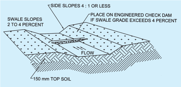
FIG. 2 GRASS SWALE
and tanks are underground facilities used for the storage of surface water, and typically constructed from reinforced cement concrete (vaults) or corrugated pipes (tanks). The water that is captured in these vaults and tanks may be used later for irrigation.
h) Designed façade for service structures that are above the ground in external areas is advisable so as to assist in developing aesthetically pleasing exterior environment. Such structures should be designed in a modular way so that it would be part of the street furniture.
c) Degree of slope, expressed as angle for example 10°, 15°, etc.