This Part deals with the development control rules and general building requirements to ensure health and safety of the public.
Loading…
this in view, many city development agencies have evolved innovative planning and development tools like transferable development rights (TDR) where the developer would receive a portion of the development rights in a new location, keeping in view the constraints in the existing land area and the development potential. Such development rights can be transferred into outskirts or new developed areas where land availability is assured. This would encourage the professionals and developers to participate in urban renewal and at the same time ensure that the developments in both the inner core areas and new areas take place in an orderly and efficient manner. The TDR concept should be increasingly encouraged by the authority dealing with urban renewal, redevelopment projects including housing and re-development projects for slum including dwellers.
Urbanization in India is taking place at a rapid pace. With 5 million population in cities at the time of independence, it has already crossed 28 million (2001 census). It is likely to be 50 million by 2021. The number of cities and towns have been expanding and there are 5 161 cities and towns of various sizes. In the Indian practice cities over 50 lakhs population have been identified as mega-cities (6 in number) and cities over 10 lakhs (29 in number) population as metro-cities. These 35 cities above 10 lakhs population is likely to be above 70 by 2021. The other cities are either small or medium towns or cities with different population limits. Urbanization in each of above cities and towns (mega-cities, metro-cities, small and medium towns and cities) will be different in nature and the development challenges are also different keeping in view the extent of urbanization, industrialization, commercialization and the nature of transportation needs. Therefore, the Code provisions should be appropriately utilized depending upon the need of hierarchy of cities for which the administrative and technical requirements have been covered in the Code for various facets of the activity.
The first version of this Part was prepared in 1970. As a result of incorporation of this Part in the revised development control rules and building byelaws of some municipal corporations and municipalities, some useful suggestions had emerged. First revision of this part was brought out in 1983, where these suggestions were incorporated to the extent possible. The major modifications incorporated in the first revision included:
a) Addition of development control rules giving guidance on means of access, community spaces and other aspects required for planning layouts.
b) Addition of provisions regarding plot sizes and frontage for different types of buildings, such as detached, semi-detached, row type and special housing schemes.
c) Requirements of open spaces for other occupancies, such as educational, institutional, assembly, industrial buildings, etc, were included.
d) Provisions relating to interior open space were elaborated, including requirements for ventilation shaft.
e) Requirements of open spaces for group housing development were covered.
f) Requirements of off-street parking spaces were covered.
g) Requirements for greenbelts and landscaping including norms for plantations of shrubs and trees were covered.
h) Requirements of certain parts of buildings, such as loft, store room, garage, basement, chimney, parapet, cabin, boundary wall, wells, septic tanks, office-cum-letter box room, meter room were included.
j) Special requirements of low income housing were covered.
The term Development Control Rules used in this Part encompasses the related aspects comprehensively with a view to promoting orderly development of an area.
This second revision is being brought out to incorporate the modifications found necessary in light of the experience gained with the use of this Part. Significant modifications incorporated in this revision include:
a) Terminology given in this Part has been made exhaustive by incorporating definitions of additional terms used, such as, access, chimney, to erect, etc, and number of terms pertaining to cluster planning for housing.
b) Detailed planning norms/open spaces for various amenities such as educational facilities, health care facilities, socio-cultural facilities, distribution services, police, civil defence and home guards, and fire services have been included.
c) Off-street parking requirements have now been also included for cities with population (i) between 1 000 000 and 5 000 000, and (ii) above 5 000 000 (see Annex B).
d) Special requirements for low income housing given in the earlier version have been modified and updated (see Annex C) based on IS 8888 (Part 1) : 1993 ‘Guide for requirements of low income housing:
Part 1 Urban area (first revision)’. In these revised provisions, single room dwelling has been discouraged, guidelines for water seal latrine have also been incorporated, and cluster planning approach has been recommended.
e) Requirements for cluster planning for housing have been added (see Annex E), which are based on the guidelines given in IS 13727 : 1993 ‘Guide for requirements of cluster planning for housing’.
f) Special requirements for low income housing for rural habitat planning has been added (see Annex F).
g) Special requirements for development planning in hilly areas has been added (see Annex G).
h) The requirements for buildings and facilities for the physically challenged have been revised, with listing of additional categories of physically challenged; modifications in requirements of ramps, stairs, doors, handrails and controls; and incorporation of additional requirements regarding windows.
j) Also, the opportunity has been utilized to update the reference to Indian Standards.
2.0 For the purpose of this part, the following definitions shall apply:
2.1 Access — A clear approach to a plot or a building.
2.2 Accessory Use — Any use of the premises subordinate to the principal use and customarily incidental to the principal use.
2.3 Alteration — A change from one occupancy to another, or a structural change, such as an addition to the area or height, or the removal of part of a building, or any change to the structure, such as the construction of, cutting into or removal of any wall, partition, column, beam, joist, floor or other support, or a change to or closing of any required means of ingress or egress or a change to the fixtures or equipment.
2.4 Approved — Approved by the Authority having jurisdiction.
2.5 Authority Having Jurisdiction — The Authority which has been created by a statute and which for the purpose of administering the Code/Part may authorize a committee or an official to act on its behalf; hereinafter called the ‘Authority’.
2.6 Back-to-Back Cluster — Clusters when joined back to back and/or on sides (see Fig. 1).
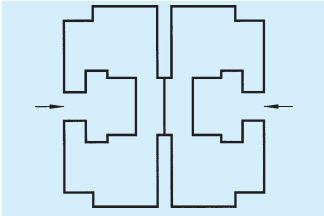
FIG. 1 BACK-TO-BACK CLUSTER
2.7 Balcony — A horizontal projection, with a handrail or balustrade or a parapet, to serve as passage or sitting out place.
2.8 Basement or Cellar — The lower storey of a building below or partly below ground level.
2.9 Building — Any structure for whatsoever purpose and of whatsoever materials constructed and every part thereof whether used as human habitation or not and includes foundation, plinth, walls, floors, roofs, chimneys, plumbing and building services, fixed platforms, VERANDAH, balcony, cornice or projection, part of a building or anything affixed thereto or any wall enclosing or intended to enclose any land or space and signs and outdoor display structures. Tents, SHAMIANAHS, tarpaulin shelters, etc, erected for temporary and ceremonial occasions with the permission of the Authority shall not be considered as building.
2.10 Building, Height of — The vertical distance measured in the case of flat roofs, from the average level of the ground around and contiguous to the building or as decided by the Authority to the terrace of last livable floor of the building adjacent to the external walls; and in the case of pitched roofs, up to the point where the external surface of the outer wall intersects the finished surface of the sloping roof; and in the case of gables facing the road, the mid-point between the eaves level and the ridge. Architectural features serving no other function except that of decoration shall be excluded for the purpose of measuring heights.
2.11 Building Envelope — The horizontal spatial limits up to which a building may be permitted to be constructed on a plot.
2.12 Building Line — The line up to which the plinth of a building adjoining a street or an extension of a street or on a future street may lawfully extend. It includes the lines prescribed, if any, in any scheme. The building line may change from time-to-time as decided by the Authority.
2.13 Cabin — A non-residential enclosure constructed of non-load bearing partition.
2.14 Canopy — A projection over any entrance.
2.15 Carpet Area — The covered area of the usable rooms at any floor level (excluding the area of the wall).
2.16 CHHAJJA — A sloping or horizontal structural overhang usually provided over openings on external walls to provide protection from sun and rain.
2.17 Chimney — An upright shaft containing one or more flues provided for the conveyance to the outer air of any product of combustion resulting from the operation of heat producing appliance or equipment employing solid, liquid or gaseous fuel.
2.18 Chowk or Courtyard — A space permanently
GROUP OPEN
open to the sky, enclosed fully or partially by building and may be at ground level or any other level within or adjacent to a building.
2.19 Chowk, Inner — A chowk enclosed on all sides.
2.20 Chowk, Outer — A chowk one of whose sides is not enclosed.
2.21 Closed Clusters — Clusters with only one common entry into cluster open space (see Fig. 2).
2.22 Cluster — Plots or dwelling units or housing grouped around an open space (see Fig. 3).
Ideally housing cluster should not be very large. In ground and one storeyed structures not more than 20 houses should be grouped in a cluster. Clusters with more dwelling units will create problems in identity, encroachments and of maintenance.
2.23 Cluster Court Town House — A dwelling in a cluster plot having 100 percent or nearly 100 percent ground coverage with vertical expansion, generally limited to one floor only and meant for self use.
2.24 Cluster Plot — Plot in a cluster.
2.25 Cooking Alcove — A cooking space having
direct access from the main room without any intercommunicating door.
2.26 Covered Area — Ground area covered by the building immediately above the plinth level. The area covered by the following in the open spaces is excluded from covered area (see Table 3):
a) Garden, rockery, well and well structures, plant nursery, waterpool, swimming pool (if uncovered), platform round a tree, tank, fountain, bench, CHABUTRA with open top and unenclosed on sides by walls and the like;
b) Drainage culvert, conduit, catch-pit, gully pit, chamber, gutter and the like;
c) Compound wall, gate, unstoreyed porch and portico, canopy, slide, swing, uncovered staircase, ramps areas covered by CHHAJJA and the like; and
d) Watchmen’s booth, pumphouse, garbage shaft, electric cabin or sub-stations, and such other utility structures meant for the services of the building under consideration.
NOTE — For the purpose of this Part, covered area equals the plot area minus the area due for open spaces.
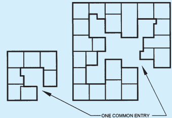
FIG. 2 CLOSED CLUSTER
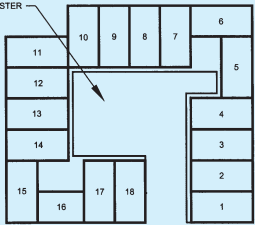
FIG. 3 CLUSTER
The land use classification may be as indicated below:
| Sl No. | Use Zone (Level 1) | Use Zone (Level 2) |
|---|---|---|
| (1) | (2) | (3) |
| i) | Residential (R) | Primary Residential Zone (R-1) Mixed Residential Zone (R-2) Unplanned/Informal Residential Zone (R-3) |
| ii) | Commercial (C) | Retail Shopping Zone (C-1) General Business and Commercial District/Centres (C-2) Wholesale, Godowns, Warehousing/Regulated Markets (C-3) |
| iii) | Manufacturing (M) | Service and Light Industry (M-1) Extensive and Heavy Industry (M-2) Special Industrial Zone Hazardous, Noxious and Chemical (M-3) |
| iv) | Public and Semi-Public (PS) | Government/Semi-Government/Public Offices (PS-1) Government Land (use determined) (PS-2) Educational and Research (PS-3) Medical and Health (PS-4) Social, Cultural and Religious (PS-5) Utilities and Services (PS-6) Cremation and Burial Grounds (PS-7) |
| v) | Recreational (P) | Playgrounds/Stadium/Sports Complex (P-1) Parks and Gardens - Public Open Spaces (P-2) Special Recreational Zone - Restricted Open Spaces (P-3) Multi-Open Space (Maidan) (P-4) |
| (1) | (2) | (3) |
| vi) | Transportation and Communication (T) | Roads (T-1)Railways (T-2)Airport (T-3)Seaports and Dockyards (T-4)Bus Depots/Truck Terminals and Freight Complexes (T-5)Transmission and Communication (T-6) |
| vii) | Agriculture and Water Bodies | Agriculture (A-1)Forest (A-2)Poultry and Dairy Farming (A-3)Rural Settlements (A-4)Brick Kiln and Extractive Areas (A-5)Water Bodies (A-6) |
| viii) | Special Area | Old Built-up (Core) Area (S-1)Heritage and Conservation Areas (S-2)Scenic Value Areas (S-3)Village Settlement (S-4)Other Uses (S-5) |
1 Areas of informal activities may be identified in the above land use categories at Level 2.
2 Mixed use zone may be identified at the development plan level, having more than one use zone with mixed activities of such use zones.
3 In all, there could be 35 use zones at the development plan level within eight land use categories at the perspective plan level as given in the above table.
4 Use premises for different activities could be provided at the project/action plan level or with the approval of the Authority as the case may be.
5 Use zone regulations for the use permissibility could be decided by the town planner depending upon the requirement/ feasibility.
3.2 The various building uses and occupancies (see 7) permitted on the various zones shall be as given in the Master Plan.
Where the use of buildings or premises is not specifically designated on the Development Plan or in the absence of Development Plan, shall be in conformity with the zone in which they fall.
Where the use of a site is specifically designated on the Development Plan, it shall be used only for the purpose so designated.
No plot shall be put to any use, occupancy or premises other than the uses identified in 3.1, except with the prior approval of the Authority.
Buildings shall be so planned, designed and constructed as to ensure fire safety and this shall be done as per Part 4 ‘Fire and Life Safety’.
Plots/dwelling units when located along a pedestrianised or vehicular ‘cul-de-sac’ road (see Fig. 4).
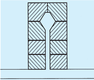
FIG. 4 CUL-DE-SAC CLUSTER
2.28 Density — The residential density expressed in terms of the number of dwelling units per hectare.
NOTE — Where such densities are expressed exclusive of community facilities and provision of open spaces and major roads (excluding incidental open spaces), these will be net residential densities. Where these densities are expressed taking into consideration the required open space provision and community facilities and major roads, these would be gross residential densities at neighbourhood level, sector level or town level, as the case may be. The provision of open spaces and community facilities will depend on the size of the residential community.
Incidental open spaces are mainly open spaces required to be left around and in between two buildings to provide lighting and ventilation.
2.29 Detached Building — A building detached on all sides.
2.30 Development — ‘Development’ with grammatical variations means the carrying out of building, engineering, mining or other operations, in, or over, or under land or water, on the making of any material change, in any building or land, or in the use of any building, land, and includes re-development and layout and subdivision of any land and ‘to develop’ shall be construed accordingly.
2.31 Drain — A conduit, channel or pipe for the carriage of storm water, sewage, waste water or other water borne wastes in a building drainage system.
2.32 Drainage — The removal of any liquid by a system constructed for the purpose.
2.33 Dwelling Unit/Tenement — An independent housing unit with separate facilities for living, cooking and sanitary requirements.
2.34 Escalator — A power driven, inclined, continuous stairway used for raising or lowering passengers.
2.35 Exit — A passage, channel or means of egress from any building, storey or floor area to a street or other open space of safety.
2.36 External Faces of Cluster — Building edges facing the cluster open spaces.
2.37 Fire Separation — The distance in metres measured from the external wall of the building concerned to the external wall of any other building on the site, or from other site, or from the opposite side of a street or other public space for the purpose of preventing the spread of fire.
2.38 Floor — The lower surface in a storey on which one normally walks in a building. The general term ‘floor’ unless specifically mentioned otherwise shall not refer to a ‘mezzanine floor’.
2.39 Floor Area Ratio (FAR) — The quotient obtained by dividing the total covered area (plinth area) on all floors by the area of the plot:
2.40 Gallery — An intermediate floor or platform projecting from a wall of an auditorium or a hall providing extra floor area, additional seating accommodation, etc. It shall also include the structures provided for seating in stadia.
2.41 Garage, Private — A building or a portion thereof designed and used for parking of private owned motor driven or other vehicles.
2.42 Garage, Public — A building or portion thereof, other than a private garage, designed or used for repairing, servicing, hiring, selling or storing or parking motor driven or other vehicles.
2.43 Group Housing — Housing for more than one dwelling unit, where land is owned jointly (as in the case of co-operative societies or the public agencies, such as local authorities or housing boards, etc) and the construction is undertaken by one Agency.
2.44 Group Open Space — Open space within a cluster.
Group open pace is neither public open space nor private open space. Each dwelling unit around the cluster open space have a share and right of use in it. The responsibility for maintenance of the same is to be collectively shared by all the dwelling units around.
2.45 Habitable Room — A room occupied or designed for occupancy by one or more persons for study, living, sleeping, eating, kitchen if it is used as a
living room, but not including bathrooms, water-closet compartments, laundries, serving and store pantries, corridors, cellars, attics, and spaces that are not used frequently or during extended periods.
2.46 Independent Cluster — Clusters surrounded from all sides by vehicular access roads and/or pedestrian paths (see Fig. 5).
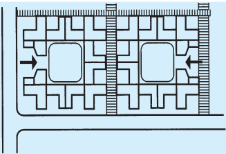
FIG. 5 INDEPENDENT CLUSTER
2.47 Interlocking Cluster — Clusters when joined at back and on sides with at least one side of a cluster common and having some dwelling units opening onto or having access from the adjacent clusters.
Dwelling units in such clusters should have at least two sides open to external open space. Houses in an interlocking cluster can have access, ventilation and light from the adjacent cluster and should also cater for future growth (see Fig. 6).
2.48 Internal Faces of Cluster — Building edges facing the adjacent cluster open space (as in case of interlocking cluster) of the surrounding pedestrian paths or vehicular access roads.
2.49 Ledge or TAND — A shelf-like projection, supported in any manner whatsoever, except by means of vertical supports within a room itself but not having projection wider than 1 m.
2.50 Lift — An appliance designed to transport persons or materials between two or more levels in a vertical or substantially vertical direction by means of a guided car or platform. The word ‘elevator’ is also synonymously used for ‘lift’.
2.51 Loft — A structure providing intermediate storage space in between two floors with a maximum height of 1.5 m, without having a permanent access.
2.52 Mezzanine Floor — An intermediate floor between two floors of any storey forming an integral part of floor below.
2.53 Occupancy or Use Group — The principal occupancy for which a building or a part of a building is used or intended to be used; for the purposes of classification of a building according to occupancy; an occupancy shall be deemed to include subsidiary occupancies which are contingent upon it.
2.54 Occupancy, Mixed — The occupancy, where more than one occupancy are present in different portions of the building.
2.55 Open Clusters — Cluster where cluster open spaces are linked to form a continuous open space (see Fig. 7).
2.56 Open Space — An area, forming an integral part of the plot, left open to the sky.
NOTE — The open space shall be the minimum distance measured between the front, rear and side of the building and the respective plot boundaries.
2.57 Open Space, Front — An open space across the front of a plot between the building line and front boundary of the plot.
2.58 Open Space, Rear — An open space across the rear of a plot between the rear of the building and the rear boundary of the plot.
2.59 Open Space, Side — An open space across the side of the plot between the side of the building and the side boundary of the plot.

FIG. 6 INTERLOCKING CLUSTER
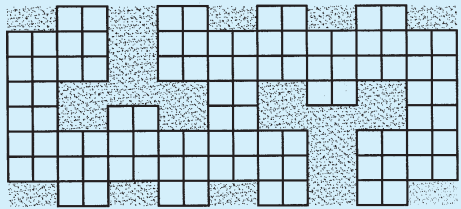
FIG. 7 OPEN CLUSTER
2.60 Owner — Person or body having a legal interest in land and/or building thereon. This includes free holders, leaseholders or those holding a sub-lease which both bestows a legal right to occupation and gives rise to liabilities in respect of safety or building condition.
In case of lease or sub-lease holders, as far as ownership with respect to the structure is concerned, the structure of a flat or structure on a plot belongs to the allottee/ lessee till the allotment/lease subsists.
2.61 Parapet — A low wall or railing built along the edge of a roof or floor.
2.62 Parking Space — An area enclosed or unenclosed, covered or open, sufficient in size to park vehicles, together with a drive-way connecting the parking space with a street or alley and permitting ingress and egress of the vehicles.
2.63 Partition — An interior non-load bearing barrier, one storey or part-storey in height.
2.64 Plinth — The portion of a structure between the surface of the surrounding ground and surface of the floor, immediately above the ground.
2.65 Plinth Area — The built up covered area measured at the floor level of the basement or of any storey.
2.66 Porch — A covered structure supported on pillars or otherwise for the purpose of pedestrian or vehicular approach to a building.
2.67 Road — See 2.82.
2.68 Road Line — See 2.84.
2.69 Room Height — The vertical distance measured from the finished floor surface to the finished ceiling surface. Where a finished ceiling is not provided, the underside of the joists or beams or tie beams shall determine the upper point of measurement.
2.70 Row Housing/Row Type Building — A row of buildings, with only front, rear and interior open spaces where applicable.
2.71 Semi-Detached Building — A building detached on three sides.
2.72 Service Road/Lane — A road/lane provided adjacent to a plot(s) for access or service purposes as the case may be.
2.73 Set-Back Line — A line usually parallel to the plot boundaries and laid down in each case by the Authority, beyond which nothing can be constructed towards the plot boundaries.
2.74 Site (Plot) — A parcel (piece) of land enclosed by definite boundaries.
2.75 Site, Corner — A site at the junctions of and fronting on two or more intersecting streets.
2.76 Site, Depth of — The mean horizontal distance between the front and rear site boundaries.
2.77 Site, Double Frontage — A site, having a frontage on two streets, other than a corner plot.
2.78 Site, Interior or Tandem — A site access to which is by a passage from a street whether such passage forms part of the site or not.
2.79 Staircover (or MUMTY) — A structure with a roof over a staircase and its landing built to enclose only the stairs for the purpose of providing protection from weather and not used for human habitation.
2.80 Storey — The portion of a building included between the surface of any floor and the surface of the floor next above it, or if there be no floor above it, then the space between any floor and the ceiling next above it.
2.81 Storey, Topmost — The uppermost storey in a building whether constructed wholly or partly on the roof.
2.82 Street — Any means of access, namely, highway, street, lane, pathway, alley, stairway, passageway, carriageway, footway, square, place or bridge, whether a thoroughfare or not, over which the public have a right of passage or access or have passed and had access uninterruptedly for a specified period, whether existing or proposed in any scheme, and includes all bunds, channels, ditches, storm-water drains, culverts, sidewalks, traffic islands, roadside trees and hedges, retaining walls, fences, barriers and railings within the street lines.
2.83 Street Level or Grade — The officially established elevation or grade of the central line of the street upon which a plot fronts and if there is no officially established grade, the existing grade of the street at its mid-point.
2.84 Street Line — The line defining the side limits of a street.
2.85 To Abut — To abut on a street boundary such that any portion of the building is on the road boundary.
2.86 To Erect — To erect a building means:
a) to erect a new building on any site whether previously built upon or not; and
b) to re-erect any building of which portions above the plinth level have been pull down, burnt or destroyed.
2.87 Tower-like Structures — Structures shall be deemed to be tower-like structures when the height of the tower-like portion is at least twice the height of the broader base at ground level.
2.88 VERANDAH — A covered area with at least one side open to the outside with the exception of 1 m high parapet on the upper floors to be provided on the open side.
2.89 Volume to Plot Area Ratio (VPR) — The ratio of volume of building measured in cubic metres to the area of the plot measured in square metres and expressed in metres.
2.90 Water-Closet (WC) — A water flushed plumbing fixture designed to receive human excrement directly from the user of the fixture. The term is used sometimes to designate the room or compartment in which the fixture is placed.
2.91 Window — An opening to the outside other than a door, which provides all or part of the required natural light or ventilation or both to an interior space.
6.1 No building shall be constructed on any site, on any part of which there is deposited refuse, excreta or other offensive matter objectionable to the Authority, until such refuse has been removed therefrom and the
site has been prepared or left in a manner suitable for building purposes to the satisfaction to the Authority.
Wherever the dampness of a site or the nature of the soil renders such precautions necessary, the ground surface of the site between the walls of any building erected thereon shall be rendered damp-proof to the satisfaction of the Authority.
Any land passage or other area within the curtilage of a building shall be effectively drained by surface water drains or other means.
6.3.1 The written approval of the Authority shall be obtained for connecting any sub-soil or surface water drain to a sewer.
No VERANDAH, balcony, or the like shall be allowed to be erected or re-erected or any additions or alterations made to a building within the distances quoted below in accordance with the current Indian Electricity Rules as amended from time-to-time between the building and any overhead electric supply line:
| (1) (2) | Vertically m(3) | Horizontally m(4) |
|---|---|---|
| a) Low and medium voltage lines and service lines | 2.5 | 1.2 |
| b) High voltage lines up to and including 11 000 V | 3.7 | 1.2 |
| c) High voltage lines above 11 000 V and up to and including 33 000 V | 3.7 | 2.0 |
| d) Extra high voltage | 3.7 | 2.0 |
| line beyond 33 000 V | (plus 0.3 m | (plus 0.3 m |
| for every | for every | |
| additional | additional | |
| 33 000 V | 33 000 V | |
| or part | or part | |
| thereof) | thereof) |
6.5 Distance of site from the normal edge of water course/area may be specified by the Authority, keeping in view the normal maximum flood/tide level.
Each plot shall have a minimum size/frontage
corresponding to the type of development as given below:
| Type of Development | Plot Size m² | Frontage m |
| (1) | (2) | (3) |
| Detached building | Above 250 | Above 12 |
| Semi-detached building | 125-250 | 8 to 12 |
| Row type building | 50-125 | 4.5 to 8 |
| NOTE — For low income housing see 12.20. | ||
6.6.1.1 The minimum size of the site for group housing development shall be as given in the Master Plan and local development control rules.
The size of the plot shall not be less than 300 m2 and its width shall not be less than 15 m.
The minimum size of plots for buildings for other uses not covered under 5.5 shall be as decided by the Authority.
4.1 Every building/plot shall abut on a public/private means of access like streets/roads duly formed.
4.2 Every person who erects a building shall not at any time erect or cause or permit to erect any building which in any way encroaches upon or diminishes the area set apart as means of access required in the Code. No buildings shall be erected so as to deprive any other building of the means of access.
The residential plots shall abut on a public means of access like street/road. Plots which do not abut on a street/road shall abut/front on a means of access, the width and other requirements of which shall be as given in Table 1.
| Sl No. | Width of Means of Access | Length of Means of Access |
|---|---|---|
| m | m | |
| (1) | (2) | (3) |
| i) | 6.0 | 75 |
| ii) | 7.5 | 150 |
| iii) | 9.0 | 250 |
| iv) | 12.0 | 400 |
| v) | 18.0 | 1 000 |
| vi) | 24.0 | above 1 000 |
NOTE — If the development is only on one side of the means of access, the prescribed widths may be reduced by 1 m in each case.
In no case, development on plots shall be permitted unless it is accessible by a public street of width not less than 6 m.
For all industrial buildings, theatres, cinema houses, assembly halls, stadia, educational buildings, markets, other buildings which attract large crowd, the means of access shall not be less than the following:
| Width of Means of | Length of Means |
|---|---|
| Access | of Access |
| m | m |
| 12.0 | 200 |
| 15.0 | 400 |
| 18.0 | 600 |
| 24.0 | above 600 |
Further, in no case shall the means of access be lesser in width than the internal accessways in layouts and subdivision.
The approach to the buildings from road/street/internal means of access shall be through paved pathway of width not less than 1.5 m, provided its length is not more than 30 m.
4.3.2.1 In the case of special housing schemes for low income group and economically weaker section of society developed up to two storeyed row/cluster housing scheme, the pedestrian pathway width shall be 3 m subject to provisions of 9.4.1(a). The pedestrian pathway shall not serve more than 8 plots on each side of the pathway; the length of the pathway shall be not more than 50 m.
4.3.3 The length of the main means of access shall be determined by the distance from the farthest plot (building) to the public street. The length of the subsidiary accessway shall be measured from the point of its origin to the next wider road on which it meets.
4.3.4 In the interest of general development of an area, the Authority may require the means of access to be of larger width than that required under 4.3 and 4.3.1.
4.3.5 In existing built-up areas in the case of plots facing street/means of access less than 4.5 m in width, the plot boundary shall be shifted to be away by 2.25 m from the central line of the street/means of accessway to give rise to a new street/means of accessway of 4.5 m width.
4.4 The means of access shall be levelled, metalled, flagged, paved, sewered, drained, chanelled, lighted, laid with water supply line and provided with trees for shade to the satisfaction of the Authority free of encroachment by any structure or fixture so as not to reduce its width below the minimum required under 4.3 and shall be maintained in a condition to the satisfaction of the Authority.
4.4.1 If any private street or any other means of access to a building is not levelled, metalled, flagged or paved, sewered, drained, channelled, lighted or laid with water supply line or provided with trees for shade to the satisfaction of the Authority, who may, with the sanction of the Authority, by written notice require the owner or owners of the several premises fronting or adjoining the said street or other means of access or abutting thereon or to which access is obtained through such street or other means of access or which shall benefit by works executed, to carry out any or more of the aforesaid requirements in such manner as he shall direct.
4.4.2 If any structure or fixture is set upon a means of access so as to reduce its width below the minimum required, the Authority may remove the same further and recover the expenses so incurred from the owner.
No premises other than highway amenities like petrol pumps, motels, etc, shall have an access direct from highways and such other roads not less than 52 m in width, which the Authority with the approval of the Highway Authority shall specify from time-to-time. The Authority shall maintain a register of such roads which shall be open to public inspection at all times during office hours. The portion of such roads on which direct access may be permitted shall be as identified in the Development Plan. However, in the case of existing development on highways/other roads referred to above, the operation of this clause shall be exempted. These provisions shall, however, be subject to the provisions of the relevant State Highway Act, and National Highway Act.
4.6 For high rise buildings and buildings other than residential, the following additional provisions of means of access shall be ensured:
a) The width of the main street on which the building abuts shall not be less than 12 m and one end of this street shall join another street not less than 12 m in width;
b) The approach to the building and open spaces on all its sides up to 6 m width and the layout for the same shall be done in consultation with the Chief Fire Officer of the city and the same shall be hard surface capable of taking the mass of fire engine, weighing up to 45 tonnes. The said open space shall be kept free of obstructions and shall be motorable.
c) The main entrance to the plot shall be of adequate width to allow easy access to the fire engine and in no case shall it measure less than 6 m. The entrance gate shall fold back against the compound wall of the premises, thus leaving the exterior accessway within the plot free for movement of fire service vehicle. If the main entrance at the boundary wall is built over, the minimum clearance shall be 4.5 m. A turning radius of 9 m shall be provided for fire tender movement.
4.7 Cul-de-sacs giving access to plots and extending from 150 m to 275 m in length with an additional turning space at 150 m will be allowed only in residential areas, provided cul-de-sacs would be permissible only on straight roads and further provided the end of cul-de-sacs shall be higher in level than the level of the starting point of such dead end road. The turning space, in this case shall be not less than 81 m2 in area, with no dimension less than 9 m.
For intersection junctions of roads meeting at right angles as well as other than right angles, the rounding off or cut off or splay or similar treatment shall be done, to the approval of the Authority, depending upon the width of roads, the traffic generated, the sighting angle, etc, to provide clear sight distance.
4.9 The building line shall be set back at least 3 m from internal means of access in a layout of buildings in a plot subject to provisions of 8.2.1.
In any layout or sub-division of land measuring 0.3 hectare of more in residential and commercial zones, the community open spaces shall be reserved for recreational purposes which shall as far as possible be provided in one place or planned out for the use of the community in clusters or pockets.
5.1.1 The community open spaces shall be provided
catering to the needs of area of layout, population for which the layout is planned and the category of dwelling units. The following minimum provision shall be made:
a) 15 percent of the area of the layout, or
b) 0.3 to 0.4 ha/1 000 persons; for low income housing the open spaces shall be 0.3 ha/1 000 persons.
5.2 No recreational space shall generally be less than 450 m2.
5.2.1 The minimum average dimension of such recreational space shall be not less than 7.5 m; if the average width of such recreational space is less than 24 m, the length thereof shall not exceed 2.5 times the average width. However, depending on the configuration of the site, commonly open spaces of different shapes may be permitted by the Authority, as long as the open spaces provided serve the needs of the immediate community contiguous to the open spaces.
5.2.2 In such recreational spaces, a single storeyed structure as pavilion or gymnasia up to 25 m2 in area may be permitted; such area may be excluded from FAR calculations.
5.3 Each recreational area and the structure on it shall have an independent means of access. Independent means of access may not be insisted upon if recreational space is approachable directly from every building in the layout. Further, the building line shall be at least 3 m away from the boundary of recreational open space.
In the case of sub-division of land in industrial zones of area 0.8 hectare or more, 5 percent of the total area shall be reserved as amenity open space which shall also serve as a general parking space; when such amenity open space exceeds 1 500 m2, the excess area could be utilized for the construction of buildings for banks, canteens, welfare centres and such other common purposes considered necessary for the industrial user, as approved by the Authority.
5.4.1 In all industrial plots measuring 1 000 m2 or more in area, 10 percent of the total area shall be provided as an amenity open space to a maximum of 2 500 m2. Such an amenity open space shall have a means of access and shall be so located that it could be conveniently utilized as such by the persons working in the industry.
In addition to community open spaces, the layouts shall provide for the amenities as given in 5.5.1 to 5.5.6. These provisions may be modified based on specific requirements, as decided by the Authority.
5.5.1 Educational Facilities
Land Area Required, Min
Land Area Required, Min
| Land Area Required, Min | ||
| 6) | General hospital (1 for every 250 000 population) | |
| i) Capacity 500 beds (initially the provision may be for 300 beds) | ||
| ii) Total area | 6.00 ha | |
| a) Area for hospital | 4.00 ha | |
| b) Area for residential accommodation | 2.00 ha | |
| 7) | Multi-speciality hospital (1 for 100 000 population) | |
| i) Capacity 200 beds (initially the provision may be for 100 beds) | ||
| ii) Total area | 9.00 ha | |
| a) Area for hospital | 6.00 ha | |
| b) Area for residential accommodation | 3.00 ha | |
| 8) | Speciality hospital (1 for every 100 000 population) | |
| i) Capacity 200 beds (initially the provision may be for 100 beds) | ||
| ii) Total area | 3.70 ha | |
| a) Area for hospital | 2.70 ha | |
| b) Area for residential accommodation | 1.00 ha | |
| Land Area Required, Min | |
| 1) Community room (1 for every 5 000 population) | |
| Area | 750 m² |
| 2) Community hall, mangal karyayala/kalyana mandapam/barat ghar/library(1 for every 15 000 population) | |
| Area | 2 000 m² |
| 3) Recreational club (1 for every 100 000 population) (see also 5.2, 5.2.1, 5.2.2 and 5.3) | |
| Area | 10 000 m² |
| 4) Music, dance and drama centre (1 for every 100 000 population) | |
| Area | 1 000 m² |
| 5) Meditation and spiritual centre (1 for every 100 000 population) | |
| Area | 5 000 m² |
| 6) Socio-cultural centre (1 for every 1 000 000 population) | |
| Area | 15 ha |
| 1) Petrol/diesel filling and servicing centreMay be permitted in central as well as sub-central business district, district centres, community centres (only filling station), residential and industrial use zones in urban areas, along the national highways, state highways, villages identified as growth centres, freight complex and on proposed major roads.Shall not be located on the road having right of way less than 30 m.Shall be approved by the explosive/fire department.Area/Sizei) Only filling stationii) Filling-cum-service stationiii) Filing-cum-service station-cum-workshopiv) Filling station only for two and three wheelers | 30 m × 17 m36 m × 30 m45 m × 36 m18 m × 15 m |
|---|---|
| 2) Compressed natural gas (CNG)/filling centrePermitted in all use zones (except in regional parks and Developed District Parks) and along the national highways, state highways and villages identified as growth centres, freight complex and on proposed major roads |
| Land Area Required, Min | ||
| Shall not be located on the road having right of way less than 30 m.Shall be approved by the explosive/fire department.Area/size for mother station (building component—control room/office/dispensing room, store, pantry and W.C. | 1 080 m² (36 m × 30 m) | |
| 3) LPG godowns/Gas godown 1 for every 40 000 to 50 000 populationThe major concern for its storage and distribution is the location which shall be away from the residential areas and shall have open spaces all around as per the Explosive Rules.i) Capacity — 500 cylinders or 8 000 kg of LPGii) Area (inclusive of chowkidar hut) | 520 m² (26 m × 20 m) | |
| 4) Milk distribution (1 milk booth for every 5 000 population)Area inclusive of service area | 150 m² | |
| Land Area Required, Min | |
| 1) Police station (1 for every 90 000 population) | |
| Area (inclusive of essential residential accommodation 0.05 ha additional to be provided for civil defence and home guards) | 1.50 ha |
| 2) Police post (1 for every 40 000 to 50 000 population) (not served by a police station) | |
| Area (inclusive of essential residential accommodation) | 0.16 ha |
| 3) District office and battalion (1 for every 1 000 000 population) | |
| i) Area for district office | 0.80 ha |
| ii) Area for battalion | 4.00 ha |
| iii) Total area | 4.80 ha |
| 4) Police line (1 for every 2 000 000 population) | |
| Area | 4.00 to 6.00 ha |
| 5) District Jail (1 for every 1 000 000 population) | |
| Area | 10.00 ha |
| 6) Civil defence and home guards (1 for every 1 000 000 population) | |
| Area | 2.00 ha |
| Land Area Required, Min | ||
| One fire station or sub-fire station within 1 km to 3 km (for every 200 000 population) | ||
| i) | Area for fire station with essential residential accommodation | 1.00 ha |
| ii) | Area for sub-fire station with essential residential accommodation | 0.60 ha |
Land Area Required, Min
Telephone exchange of 40 000 lines (1 for every 400 000 population) Area 4.00 ha
Telegraph booking counter (1 for every 100 000 population) Floor area to be provided in community centre 200 m2
Telegraph booking and delivery office (1 for every 500 000 population) Floor area to be provided in district centres 1 700 m2
Land Area Required, Min
Post office counter without delivery (1 for every 15 000 population) Floor area to be provided in local shopping centre 85 m2
Head post office with delivery office (1 for 250 000 population) Area 750 m2
Head post office and administrative office (1 for 500 000 population) Area 2 500 m2
District sport centre (1 for 100 000 population) Area 8.00 ha
Neighbourhood play area (1 for 15 000 population) Area 1.50 ha
Residential unit play area (1 for 5 000 population) Area 5 000 m2
Local shopping including service centre (1 for 15 000 population) Area 4 600 m2
Community centre with service centre (1 for 100 000 population) Area 5.00 ha
District centre (1 at district level/1 for 500 000 population) Area 7.50 ha
Local wholesale market (1 for 1 000 000 population) Area 10.00 ha
| Land Area Required, Min | |
|---|---|
| 1) Electric crematorium (1 for large size towns) | |
| Area | 2.00 ha |
| 2) Cremation ground (1 for 500 000 population) | |
| Area | 2.50 ha |
| 3) Burial ground (1 for 500 000 population) | |
| Area | 4.00 ha |
| 1) Religious campus (1 for 100 000 population) | Land Area Required, Min |
|---|---|
| Area | 5.00 ha |
| 5.5.11 Electrical Sub-station | |
| 1) 11 kV Sub-station (1 for 15 000 population) | Land Area Required, Min |
| Area | 500 m<sup>2</sup> |
| 2) 66 kV Sub-station (2 for 100 000 population) | |
| Area for each Sub-station | 6 000 m<sup>2</sup> (that is 60 m × 100 m) |
| 3) 220 kV Sub-station (1 for 500 000 population) | |
| Area | 4.00 ha |
| Land Area Required, Min | |
| 1) Three wheeler and taxi stand (1 for 15 000 population) | |
| Area | 500 m² |
| 2) Bus terminal (1 for 100 000 population) | |
| Area | 4 000 m² |
| 3) Bus depot (1 for 500 000 population) | |
| Area | 2.00 ha |
The site shall be identified in locations, which are not proximous to residential areas
| Land Area Required, Min | |
|---|---|
| 1) Dhobi ghat with appropriate arrangements for water and drainage facilities and it shall be ensured that the water bodies are not polluted as a result of such activities (1 for 100 000 population) | |
| Area | 5 000 m² |
5.6 Every layout or sub-division shall take into account the provisions of development plan and if the land is affected by any reservation for public purposes, the Authority may agree to adjust the location of such reservations to suit the development.