31.1 Development Concept for Land Use Plan 2040
As population and human aspiration increase, land becomes an increasingly scarce resource. This emphasizes the importance of Land Use planning for optimum usage of land and to guide development to conform with the land suitability to create a sustainable and resilient city.
The development direction for Kochi Municipal Corporation has been formulated on the basis of various factors such as the concepts adopted in existing Structure Plan, plan for Kochi City Region, present trend of land development, and assessment of factors such as Building footprint density, FAR utilization, net population density, environmental vulnerability,projected requirements, proposed development policies and the like.
Based on these assessments the concept for the development of the planning area for the horizon year has been envisaged through four zones identified with different strategies. The development concept is summarized below:
Zone 1 is predominately focused on heritage conservation, retrofitting and decongestion of the area along with Infrastructure upgradation.
Zone 2 encompasses the Transit Oriented Development zone where through the provision of increased FAR and mixed use, the area will be developed into one that is of high density, compact mixed use area.
• Zone 3 encompasses areas that shall follow the existing KMBR provisions
• Zone 4 focuses on risk informed planning through incorporation of more regulations.
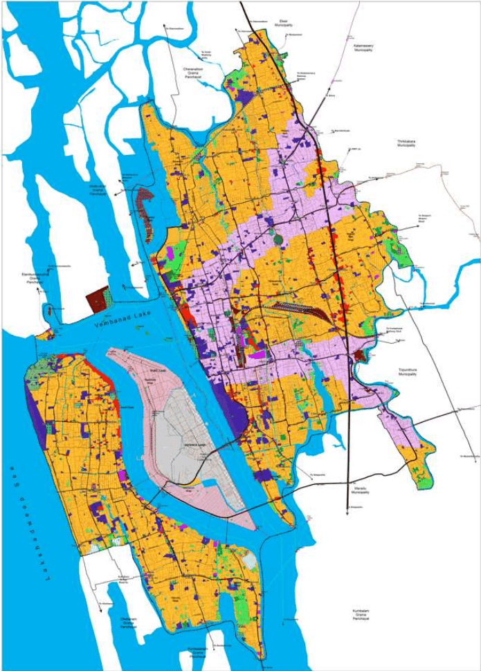
Existing land use map (2020) is attached with the master plan report. Based on the objections and suggestions received for the published master plan, further land use vetting and ground check was done for the proposed land use map to obtain clarification regarding land use , road widths etc by the special committee. Disparities that had existed with land use like water bodies, conservation area etc. has been rectified through this process.
For effective implementation of the master plan proposals and intended regulations proposed land use map 2040 has been provided. Inorder to substantiate the proposed land use map, Transportation network map 2040 and 19 module maps of the proposed land use (A,B,C,D,E,F,G,H,J,K,L,M,N,P,Q,R,S,T,U) have been provided with the master plan. For detailed understanding of the land use, road widths, survey numbers, risk area etc. the module map may be refered. The area to be refered in module map is the area bounded within the designated grid.
Land Use Categories
Land Use categories are generally categorized on traditional concepts. For the planning area, on the basis of the geographic and spatial characteristics, the Land Use categories adopted for Kochi Municipal Corporation are as follows:
Kochi Municipal Corporation
PROPOSED LAND USE
-
Residential
-
Commercial
-
Public and Semi-Public
-
Industrial
-
Transportation
-
Dry Agriculture
-
Mixed Zone (Residential & Commercial)
-
Heritage Zone
-
Tourism Promotion Zone
-
Recreational-1(Open Space)
-
Recreational-2 (Built up)
-
Transit Oriented Development
-
Public Utilities
-
Conservation Area
-
Eco-Sensitive Areas
-
Mangalavanam Bird Sanctuary
-
Water Bodies
-
Buffer(Water Bodies)
-
Defence land
-
Port land
-
Special Zone A : Wholesale Market
-
Special Zone B : Urban Agriculture Facilitation Centre
-
Special Zone C : IT Industries
The special use zones are proposed where land is specifically reserved for essential projects in the horizon year. The details of each category are listed in the following sections.
Residential
It is observed from the existing land use pattern that the majority share is occupied by residential land use. The major strategy adopted for this land use is for the redensification of congested areas and to control the residential growth into nearby Municipalities. The proposed land area under the land use is 33.67 sqkm which is 35.43% of the total area. The proposed percentage falls within the planning norms. In addition to this, residential uses are also permissible in other zones as detailed out in the development control regulations.
PROPOSED LAND USE
Commercial
Commercial land use forms an important activity of the population within the planning area and has a deciding effect on the spatial structure of the city. The major commercial areas are concentrated around the Central city area thereby causing a convergence point of people from different parts of the city and increasing intra-city trips. On the basis of hierarchy of commercial nodes, commercial centers at 13 locations have been identified for development. The proposed commercial land use occupies 1.3 sqkm which is 1.37% of the total. The reduction in the percentage is due to the incorporation of commercial land uses in to the TOD zone and into the mixed residential & commercial zone.
Public and Semi-Public
The proposed public and semi-public land use entails 5.04 sqkm which occupies 5.32% of the total area. This land use incorporates provision of physical& social infrastructure facilities such as health, education, civic amenities public utilities and the like. This zone also includes land and offices owned by the Central Government, Sate Government, Port Trust and Defence.
Industrial Use
The presence of industries within the planning area is limited. However, the peripheral areas have a strong industrial presence. Kochi Municipal area has the potential to be developed with IT industries and the development of Kochi-Bangalore Industrial corridor can further this potential. The proposed Industrial Land use occupies 0.47 sqkm of land which is 0.49 % of the total area.
Transportation
Trafnsportation is highly essential in shaping cities, enabling economic activities, providing accessibilities, and enhancing quality of life. The road network development entails restoration of the grid iron pattern according to hierarchy with minimum distrubances to the existing building footprint. Regional level strategies have also been devised through the development of ring and radial roads. Other proposals include freight complexes, cargo park, area redevelopment projects, over bridges, rail over bridges, junction improvements, multi-modal hubs, off-street parking facilities, bus terminals, water transport services and the like. The area under the proposed land use is 9.17 sqkm which is 9.66% of the total area.
Dry Agriculture
Dry Agriculture land parcels that are contiguous have been retained. The area under this category is 0.74 sqkm which is 0.78% of the total area.
Mixed Zone (Residential and Commercial)
Mixed use of Residential and Commercial are important for the development of compact and walkable cities. This zoning is intended to accommodate various activities to ease pressure on urban land. Mixed zone land use for Kochi is proposed to primarily comprise of a mix of residential and commercial land use. The proposed area under this category is 2.3 sqkm which is 2.4% of the total area.
89
PROPOSED LAND USE
Heritage Zone
Heritage zone primarily comprises of the areas identified as architecturally, historically and aesthetically significant in terms of heritage. Any alterations to it shall come under the purview of Kerala art and heritage commission constituted under the KT & CP act. This area is located at Fort Kochi and is earmarked as an area to be primarily conserved for its historic and cultural significance. In addition to the area, all Heritage buildings with cultural and historical significance have been identified to be under the purview of Art&Heritage Commission.The proposed area is 0.39 sqkm and comprises of 0.41% of the total land use.
90
Tourism Promotion zone
The tourism promotion zone consists of the area identified in Thanthonithuruthu for tourism activities. At present the area comprises of lush greenery, waterbodies intermingled with aquaculture and coconut plantations. The backdrop has high potential for sustainable tourism activities that can improve the economic status of the local population. The area comprise of 0.33 sqkm which is 0.35 % of the total land use.
31.2.10 Mangalavanam Bird Sanctuary
The area comprises of Mangalavanam Bird sanctuary which is highly ecosenstive and the character of which needs to be preserved. The area comprise of 0.03 sqkm which is 0.04 % of the total land use.
31.2.11 Recreational-1(Open Space)
This land use category includes parks and open spaces. For the proposals in the sector, in order to meet the planning norms and incorporate concepts such as active city & sponge city, areas have been identified as parks and open spaces. Varied projects have been provided in the above mentioned areas, in natural resource rich areas and in other land parcels on the basis of analysis. The existing parks and open spaces have also been retained under this land use. The area under this category has increased to 0.64 sqkm which is 0.67% of the total area.
31.2.12 Recreational-2 (Built Up)
This land use category includes higher order recreational facilities that include built up like a stadium, gymnasium sports centre, swimming pool, amusement parks etc. The proposed area under this category is 0.13 sqkm which is 0.14% of the total area.
31.2.13 Transit Oriented Development (TOD)
This zone entails high density mixed use compact development. The corridor identified for TOD is along the metro corridor and its extension, taking a 500 m buffer on either side of the alignment of the metro line. The area will offer higher FAR benefits for increased vertical and compact development. The zone will also integrate concepts like multi-modal integration, promote NMT provisions, provide active and engaging recreational spaces and the like. The area under this category is 10.79 sqkm which is 11.37% of the total area. The development is focused in this zone and the area will have a significant contribution to reduce the urban sprawl into the nearby municipalities.
PROPOSED LAND USE
31.2.14 Public Utilities
This category of land use includes areas such as electric substations, sewage treatment plants, slaughter houses and the like. Moreover, a Public Utility zone has been identified in every Health Circle to establish a Cluster Level Facilitation Center which is envisioned to serve socio-cultural functions and utilities such as Anganwadis, electric charging stations, assembly points, Pakal Veedu etc. The area under the category is 0.3 sqkm which is 0.32% of the total area.
31.2.15 Conservation Area
The areas that have been identified as conservation areas are integral in any city. The ltype of land that fall under this land use are marshy areas, paddy lands, wetalnds etc. The development in these areas are to be in conformity to the Kerala Paddy & Wetland Act, 2008. The area under the category is 1.89 sqkm which is 1.9% of the total area.
31.2.16 Eco-Sensitive Area
This category includes mangroves that are ecologically fragile and vital to the city’s ecosystem. The area under this category is 0.2 sqkm which is 0.23% of the total area.
31.2.17 Water Bodies
The water bodies need to be conserved and preserved. The inland canals are proposed to be rejuvenated and sediments to be removed to ensure proper cross drainage across the city. The area under this category is 19.71 sqkm which is 20.8 % of the total area.
31.2.18 Buffer (Water bodies)
A 7 m buffer has been proposed and maintained along all canals within the city. The area along the canals is proposed to be maintained as parks and open spaces to create interconnected blue-green infrastructure for the city. The buffer is provided to curb the encroachment of water bodies and to maintain the integrity of the area. It is essential to provide areas along the canal that act as sponges to help in better stormwater infiltration. The proposed area under this category is 0.86 sqkm which is 0.9% of the total area.
31.2.19 Defence land
91
The area comprises of land area under the ownership of defence. The proposed area under this category is 3.59 sqkm which is 3.78% of the total area.
31.2.20 Port land
The area comprises of land area under the ownership of Cochin Port Trust. The proposed area under this category is 3.31 sqkm which is 3.48% of the total area.
31.2.21 Special Zone A: Wholesale Market
Special Zone A refers to the land reserved for the development of a new wholesale market for Kochi Corporation at its periphery. The new wholesale market is intended to be developed for intra-urban freight movement with warehousing and storaging facilities.
PROPOSED LAND USE
31.2.22 Special Zone B: Urban Agriculture Facilitation Centre
Special Zone B refers to the land earmarked for the establishment of an Urban Agriculture Facilitation Centre. The center is intended to promote urban agriculture at a health circle level.
31.2.23 Special Zone C: IT Industries
Special Zone C is reserved for the establishment of IT based industries covering IT services, IT-enabled services(ITES) and the like.
Proposed Land Use Map
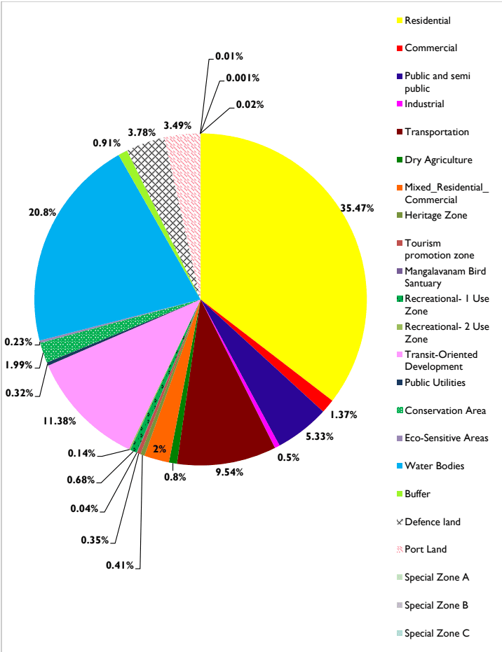
The proposed land use map and the area breakup of each of the above proposed land use categories are given below. The percentage under each zone is not strictly in conformity with the URDPFI guidelines. However the predominant mixed use zone may meet the deficiency in meeting the expected standards.
| Sl no | Proposed Landuse | Area(SqKm) | Percentage |
| 1 | Residential | 33.65 | 35.47 |
| 2 | Commercial | 1.30 | 1.37 |
| 3 | Public and semi public | 5.05 | 5.33 |
| 4 | Industrial | 0.47 | 0.50 |
| 5 | Transportation | 9.05 | 9.54 |
| 6 | Dry Agriculture | 0.76 | 0.80 |
| 7 | Mixed_Residential_Commercial | 2.31 | 2.44 |
| 8 | Heritage Zone | 0.39 | 0.41 |
| 9 | Tourism promotion zone | 0.33 | 0.35 |
| 10 | Mangalavanam Bird Santuary | 0.04 | 0.04 |
| 11 | Recreational- 1 Use Zone | 0.64 | 0.68 |
| 12 | Recreational- 2 Use Zone | 0.13 | 0.14 |
| 13 | Transit-Oriented Development | 10.80 | 11.38 |
| 14 | Public Utilities | 0.30 | 0.32 |
| 15 | Conservation Area | 1.89 | 1.99 |
| 16 | Eco-Sensitive Areas | 0.22 | 0.23 |
| 17 | Water Bodies | 19.74 | 20.80 |
| 18 | Buffer | 0.87 | 0.91 |
| 19 | Defence land | 3.58 | 3.78 |
| 20 | Port Land | 3.31 | 3.49 |
| 21 | Special Zone A | 0.01 | 0.01 |
| 22 |