In a city like Kochi, land, and legacy issues surrounding land use patterns, has become the biggest deterrent in developing new and better infrastructure. The land often shows a fragmented holding pattern, divided into many plots which are small and irregularly shaped each leading to unplanned development. This consequently results in poor infrastructure, inadequate provision of public services/utilities, lack of public/community space, lack of access to public transport among others.
Modern principles of sustainable neighbourhood planning call for efficient street networks and high-density development with mixed land use. Clearly, this is hard to achieve in the current spatial organization seen in Kochi. This project seeks to redevelop an area of the urban fabric through a scientifically planned and executed land reconstitution. This pilot model can be adopted for other urban regions in Kerala. The proposed project would be designed to be financially sustainable, with fair returns to the persons affected in the project area and at the same time ensuring surplus fund are generated for further urban growth.
URBAN REFORMS
The project aims to rejuvenate the existing commercial and residential hub of Kochi specifically “The Marine Drive” and its precincts. The area which is the existing Central Business District (CBD) is already saturated with high rise apartment complexes and office complexes. This creates a need to look beyond Marine Drive for further planned growth. At the same time the proposed project should serve as a continuum of the CBD with easy access and be an organic extension of the same. Care should be taken to ensure that the required environmental safeguards are adopted. Not only should no damage be done to the ecosystem, but the project should help to foster and stabilize the existing ecosystem. All stakeholders affected are treated justly and fairly. The development of Marine drive is restricted towards the southern side which has land parcels owned by BPCL and Cochin Shipyard.
The identified project area starts from Marine Drive and Mangalavanam Bird Sanctuary in the southern part to Cheranallore grama panchayath in the north including Vaduthala, Pachalam area and the Mulavukkad Island on the eastern side across the backwaters. One side of the project area is bound NH 966A (container terminal road). Based on the different considerations and understanding, it has been proposed that the new development would be in the form of a a looped waterfront development along Queensway-Pachalam-Vaduthala-Mulavukkad stretch with a total length of approximately 9.1 km. This would include a bridge for circular connectivity. Along with the new development, ecological restoration and conservation of Mangalavanam Bird Sanctuary and its influence area would be taken up as a major component considering its ecological importance and sensitivity.
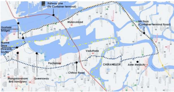
Figure 30:7 Project area for Urban Sustainable Land Reconstitution Project Source: KIIFB
Institutional Setup: The scheme would be implemented by forming a Special Purpose Vehicle (SPV) which would be the nodal agency for spearheading the project. The SPV would consist of Kochi Municipal Corporation, Greater Cochin Development Authority, Goshree Island Development Authority, and the respective local bodies with State Government as its main advisory. They would be entrusted with preparing the master plan
Kochi Municipal Corporation
URBAN REFORMS
and obtaining all the necessary clearances and clarifications. Once the master plan is finalized a notification shall be released designating the area for development and initiate the survey work. Once the necessary clearances are obtained the development maybe initiated in a phased manner.
As per the G.O.(Ms)No.186/2022/LSGD dated Thiruvananthapuram 15-08-2022 it has been decided that a general body chaired by the Hon. Chief Minister of Kerala and Project Implementation Committee chaired by Additional Chief secretary, LSGD needs to be created. A special area plan is to be developed for this area. As per Kerala Town and Country Planning act 2016, section 62(6) the provisions of the spatial plan for a special area sanctioned in accordance with this act shall prevail over the provisions of any other plan for the same area.
Detailed Town Planning scheme at Palluruthy- Edakochi area along Pazhanjhi thodu
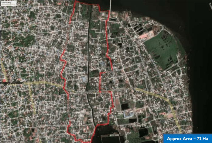
Figure 30:8 Tentative Project Area identified at Palluruthy EdaKochi area
Pazhanjhi thodu is a 1.6 km long canal with an average width ranging from 15 to 20 m in Edakochi area playing a key role in assisting the effective drainage of the area. The canal which was navigable once is now a backyard drain with heavy silt deposition and no effective depth for boat movement. A detailed town planning scheme can be proposed in this area to rejuvenate the canal and to effectively utilize the open spaces within the area for community activities and recreation. The aquaculture activities and rural backdrop can successfully add to the tourism potential of the area. The canal could be utilized again as a
Kochi Municipal Corporation
URBAN REFORMS
navigable route using pedal boats and can be integrated with tourism activities. An approximate area of 72 hectares has been identified along Pazhanjhi thodu for this purpose.
While undertaking the detailed town planning scheme, It is proposed to additionaly take up atleast 4 % of conservation area to be developed in sustainable manner respecting the chances of urban floods and the like. Techniques like dry and wet flood proofing can be adopted here without causing hindrances to the natural water flow. Engineering solutions like effective drainage systems needs to be adopted here as a prerequisiste. Minimum 2% of the conservation area can be earmarked for water retention to accommodate the excess water that may be displaced.