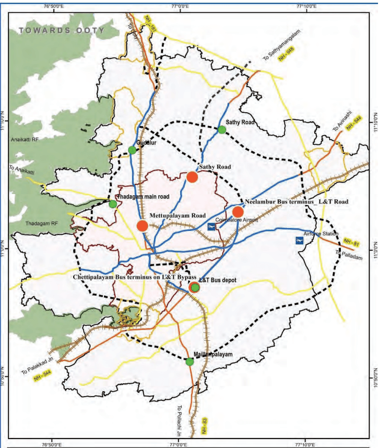
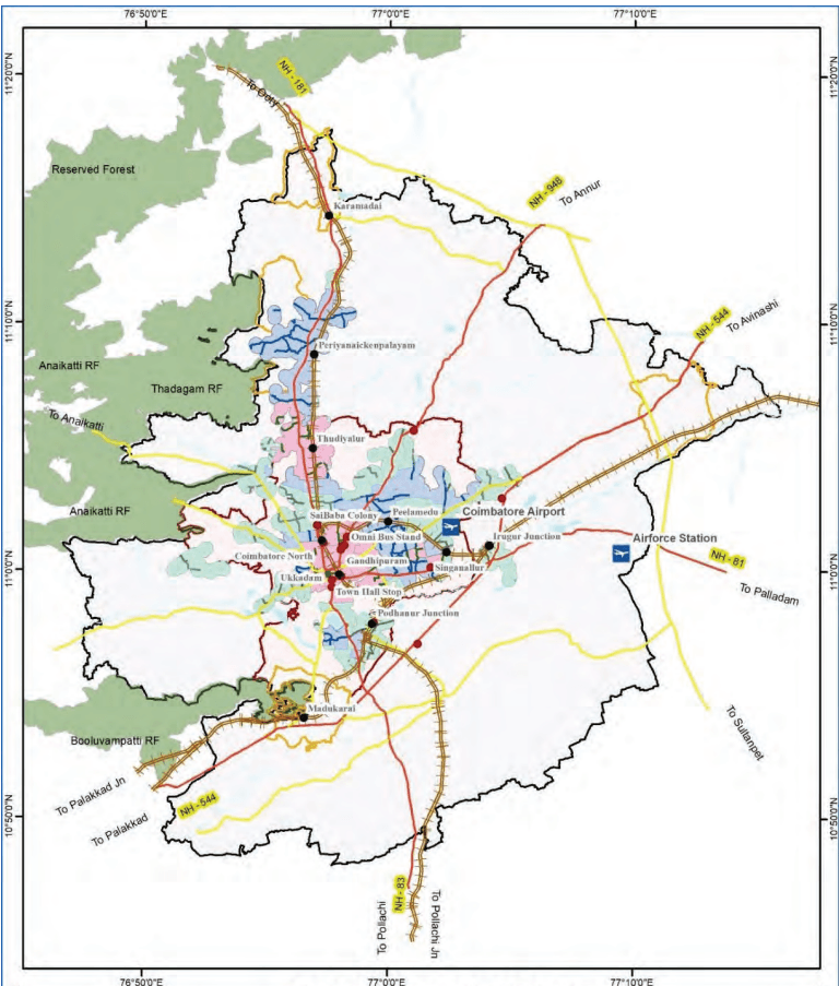
Currently there are 12 depots which serve as operational hubs for the existing bus service. The existing depots are located in the corporation area. By the year 2041, the number of depots will need to increase to support the expanded fleet and services. An additional 5 depots are proposed strategically located considering land availability, to reduce idle running time and improve operational efficiency. Apart from the 5 locations identified, the two proposed bus terminals on L&T bypass road will have depot facilities that will have the capacity to accommodate both town and mofussil buses.
Table 7.19Proposed Bus Depot.
S. No
Proposed Bus Depot Locations
Village
Area (acres)
Phase
1
Sathy Road on proposed Outer Ring Road
Kunnathur, Masagovund-enchettipalayam
10
Phase -1
2
Thadagam Main Road
Somayampalayam
10
Phase -1
3
Chettipalayam along L&T Bypass
Chettipalayam
15
Phase -1
4
Mailleripalayam on proposed Outer Ring Road
Mailleripalayam
5
Phase -2
5
Therukkupalayam on proposed Outer Ring Road
Gudalur
5
Phase -2
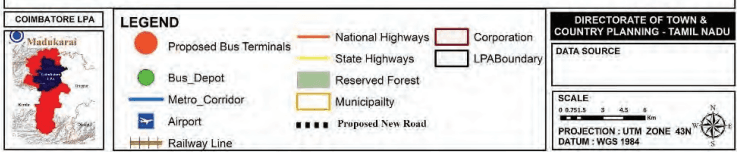
Map 7.8: Proposed Bus Terminals and Depots
7.7.3.6Improvement of Existing Railway Stations
Coimbatore serves as a crucial rail transit hub, facilitating intercity and suburban mobility. Coimbatore Junction, the primary railway terminal, experiences significant passenger demand, highlighting the need for infrastructure upgrades and improved accessibility. The other major railway stations are Coimbatore North Station, Podanur Station, Irugur Station for intracity passenger movement.
As per primary survey analysis, 37.3% of users rely on public transport and 18% on intermediate public transport for station access, the rail mode share remains critically low at 0.9%, highlighting gaps in accessibility and limited integration with other transport networks. Enhancing railway station infrastructure and accessibility is essential to decongest the city core.
Passenger Load Redistribution:
Upgrade Irugur, Singanallur, Peelamedu, and Podanur stations to accommodate long-distance trains, reducing dependency on Coimbatore Junction.
Enhance infrastructure at these stations to improve passenger convenience and decongest the city core.
Infrastructure and Facility Enhancements:
Modernize stations with waiting areas, drinking water, sanitation, and security provisions such as CCTV surveillance.
• Improve station illumination and pedestrian safety measures.
Accessibility and Last-Mile Connectivity:
• Strengthen Road infrastructure leading to railway stations by ensuring wider access roads, dedicated IPT bays, and improved public transport connectivity.
Restrict on-street parking near station entrances to streamline vehicular movement.
Parking and Pedestrian Infrastructure:
Implement structured parking solutions to reduce traffic congestion at station access points.
Construct Foot Over Bridges (FOBs) to facilitate safe pedestrian movement across platforms.
Table 7.20Improvement of Existing Railway Station and Phasing
S. No
Improvement of Existing Railway Stations
Phase
1
Coimbatore North Station
Phase-1
2
Podanur Railway Station
3
Peelamedu Railway Station
4
Singanallur Railway Station
5
Irugur Railway Station
6
Madukkarai Railway Station
Phase-2
7
Periyanaickenpalayam Railway Station
8
Thudiyalur Railway Station
Phase-3
9
Sulur Railway Station
10
Narasimhnaickenpalayam Railway Station
4Upgradation of Existing Bus Terminals
Town buses at existing terminals at Thudiyalur, Mettupalayam Road and Gandhipuram will continue catering to their respective regions, ensuring minimal disruption to passengers. These Bus Terminals will continue serves as a key transit hub, connecting Coimbatore with various regions and is proposed to be upgraded with infrastructure enhancements as below.
Reorganized bus bays, and designated pedestrian zones to ensure smooth operations.
IPT (Intermediate Public Transport), Feeder bus services and last-mile connectivity solutions will be implemented to support passenger movement from terminals to the city centre.
• Widened footpaths, safe crossings, barrier-free access, and well-lit waiting areas for improved safety and accessibility.
Enhancements within the existing footprint, exploring multilevel structures for parking and passenger facilities.
Adoption of solar lighting, rainwater harvesting, and waste management to enhance environmental sustainability.
Additionally, existing omni bus terminal facilities at Gandhipuram are proposed to be improved to cater to the needs of omnibus operators and passengers until the operations are shifted to the new proposed terminals.
7.7.3.7Proposal of Commuter Rail System
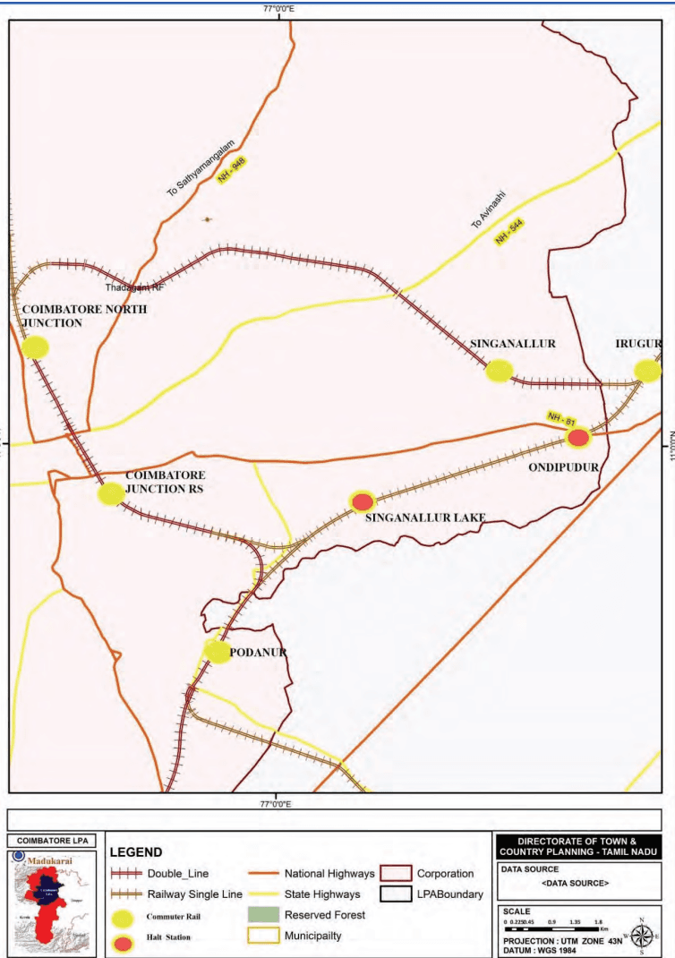
Significant percentage of people commute between Coimbatore and nearby towns such as Mettupalayam, Pollachi, Irugur and other outskirts areas. Most of these commuters travel by road i.e. by buses, para transit modes and their own vehicles. Although Coimbatore is connected with Mettupalayam, Pollachi, Irugur and other outskirts areas by regional rail system, but there are no regular commuter rail services. Considering the future population growth and its traffic interaction with Coimbatore, it is important to augment the rail network by connecting missing link and run suburban services for the frequent commuters. However, the feasibility of using the existing tracks for running commuter rail system needs to be validated further.
It is proposed to double existing rail lines (Irugur–Podanur, Coimbatore North–Mettuplayam, Podanur–Pollachi section) with automatic signalling. include development of two halt stations between Irugur to Podanur section.
Table 7.21Upgradation of rail lines and Phasing
S. No
Upgradation of rail lines for commuter rail services
Quantity
Phase
1
Doubling of Irugur-Podanur Line
8.6km
Phase-1
2
Addition of missing link from Coimbatore Junction towards Irugur
1.2km
3
Automatic signalling for ring section of Coimbatore Railway line (Coimbatore junction-Coimbatore North-Peelamedu-Irugur-Podanur-Coimbatore-Junction)
32.6km
4
Halt stations at Singanallur Lake and Ondipudur
2 nos.
5
Doubling of Coimbatore North-Mettupalayam Line (within LPA)
30.3km
Phase-2
6
Doubling of Podanur-Pollachi line (within LPA)
19.1km
7
Automatic signalling for other rail lines in LPA
96km
Map 7.9: Commuter Rail System
7.7.3.8Development of Regional rail lines
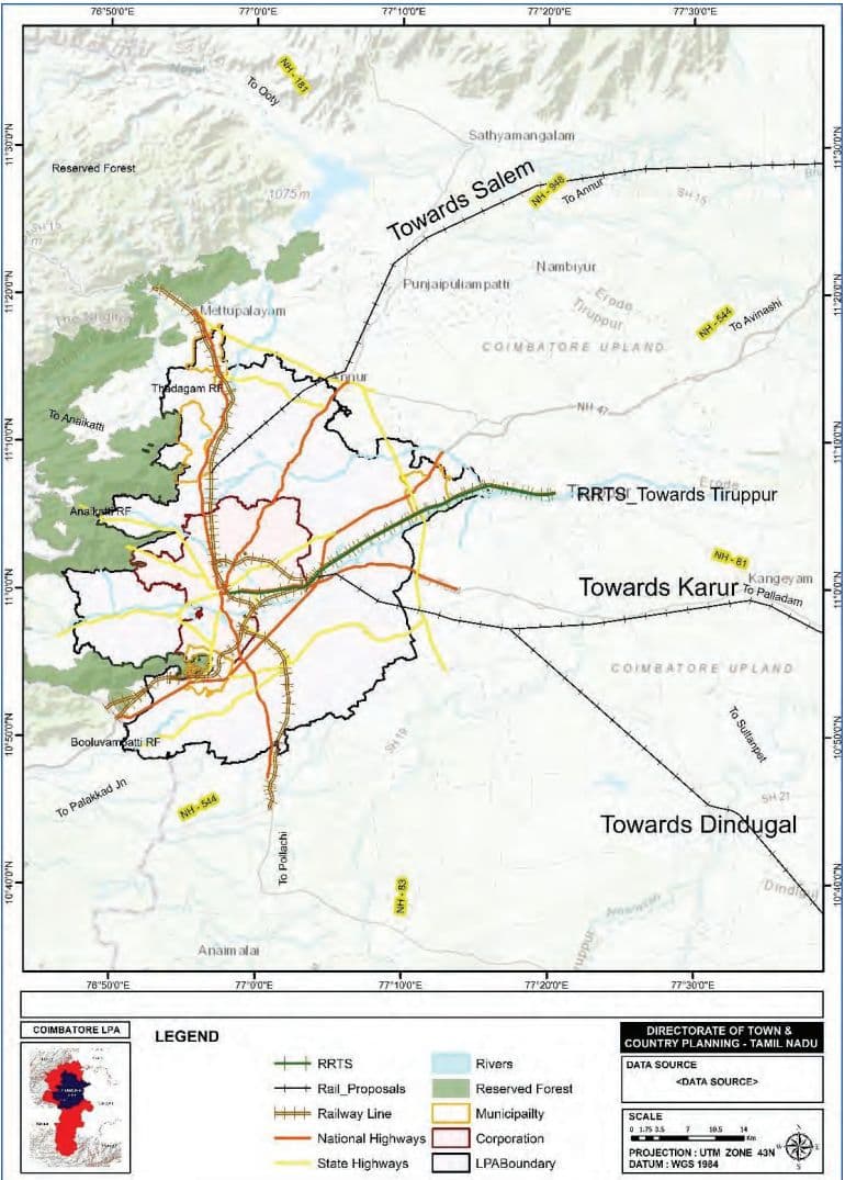
At present, there is a high amount of interaction and development in the belt between Coimbatore-Tiruppur-Erode-Salem which benefits from strong highway and railway connectivity. For more balanced regional growth, and better connectivity to surrounding towns, it is proposed to develop three new railway lines as shown in Map 7.10.
These proposed rail lines will also help decongest the heavily used Coimbatore-Salem rail line by providing alternative routes to different regions of Tamil Nadu.
A Regional Rapid Transit System (RRTS) is also proposed to provide high-quality semi-high-speed connectivity in the region connecting Coimbatore to Salem via Tiruppur and Erode. The feasibility study for the RRTS is being undertaken by Chennai Metro Rail Limited (CMRL).
Map 7.10: Proposed Regional Rail Connectivity
7.7.4NMT and Pedestrian Infrastructure Development
The NMT Infrastructure Improvement Plan proposes continuous footpaths on both sides of major roads, dedicated cycle lanes wherever possible, and pedestrian priority at crossings and public spaces. These measures aim to enhance safety, accessibility, and promote walking and cycling as sustainable modes of transport in Coimbatore.
The vision for the NMT plan is as follows:
Road network with connected and dedicated pedestrian pathways, up to 100% of arterial and sub-arterial roads in LPA and bus route roads
Increased accessibility to the public transportation network
Road upgrades (road markings & signages, encroachment free, barrier free & inclusive design etc.) on all arterial/ sub-arterial roads as per IRC standards.
7.7.4.1 Approach for NMT Proposals
A comprehensive Non-Motorised Transport (NMT) plan has been developed to identify and establish clusters in LPA that will enhance the provision of continuous footpaths, supporting seamless connectivity and complementing the existing public transport network and overall accessibility and network improvements.
This approach covers multiple parameters to ensure optimal pedestrian accessibility and safety. The factors considered include areas with high footfall at existing bus stops, proximity to schools and educational institutions and hospitals, accident data analysis, and the availability and condition of Footpaths. By focusing on these parameters NMT clusters have been identified for the phase-wise improvement of NMT.
Schools and educational institutions were a critical focus, as these are significant generators of pedestrian traffic. A 500-meter buffer around major dense schools was established to ensure safe and continuous footpaths, thereby encouraging walking among students. Heat maps of accident locations and fatalities, were analysed to identify the high-risk areas and these were clubbed as clusters.
The plan prioritizes first- and last-mile connectivity to public transport, linking NMT corridors to key destinations such as schools, markets, offices, and bus terminals. A continuous, gap-free network is essential, along with clear wayfinding systems to improve navigation for both pedestrians and cyclists. Enforcement will be key, with measures to prevent encroachments on NMT lanes and footpaths, rail guards on medians to deter jaywalking, and pedestrian crossings every 1 km on arterial roads.
7.7.4.2 Key NMT Proposals
Continuous footpaths are proposed to be developed along all NH, SH and MDR, covering a network length of 909 km in the local planning area. A total of 127 clusters have been identified for NMT improvement covering a major road network length of 471km within the clusters. As the first priority, it is recommended that footpath network shall be developed on all roads that are categorised as NH and SH in the area. The footpaths shall be designed as per street design guidelines/IRC standards.
Table 7.23Network Length for NMT Improvement
SN
Category
Length (km)
Phasing
1
Arterial Roads (NH, SH)
150.4
Phase 1
2
Other Roads (As part of clusters)
71.5
3
Arterial Roads (NH, SH)
267.9
Phase 2
4
Other Roads (As part of clusters)
190.3
5
Arterial Roads (NH, SH)
20.3
Phase 3
6
Other Roads (As part of clusters)
209
Total Network
909.4
Additionally, cycle lanes are proposed to be included where feasible based on right-of-way availability. The cycle lanes shall be planned to form a network of cycling infrastructure, providing safe conditions for cyclists. Cycle lanes should be planned and designed in accordance with IRC11:2015.
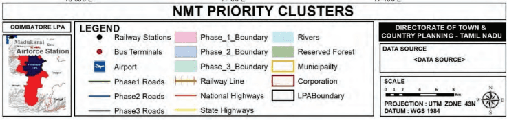
Map 7.11: Map showing NMT cluster
7.7.4.3 Pedestrian and Cycling Infrastructure Components
Footpaths will be developed continuously on both sides of major roads, with a minimum width of 1.8 m (1.5 m on narrow roads), raised with 150 mm unmountable kerbs, and aligned with land availability along mobility corridors and commercial zones. Zebra crossings will be provided at all at-grade junctions, and tabletop crossings will be used where continuity is broken. Footpaths will have clearly defined walking zones, furniture zones (for benches, bins, lights, etc.), and frontage zones near buildings. Materials will be non-slip and even, ensuring a uniform gradient.
Pedestrian crossings will include raised tabletop designs, zebra markings, and refuge islands at wide roads to improve visibility and safety. For safety and accessibility, all curbs will include ramps, tactile paving for the visually impaired, audible signals, and adequate lighting. Public comfort will be enhanced with shade-providing trees, seating areas, and basic amenities like drinking water and toilets where possible.
Cycle Tracks will be segregated and safe, with dedicated space and priority at intersections. They will be integrated with bicycle-sharing systems and secure parking to promote daily cycling. Cycle tracks will be segregated with curbs, bollards, or green buffers, and designed with minimum widths of 2 m (one-way) and 3 m (two-way). They will be given priority at junctions and integrated into key commuting routes. Bike parking will be located at transit points, schools, parks, and commercial areas, with provisions for covered and secure stands. Shared NMT corridors will be encouraged in low-speed (<30 km/h) streets using signage and traffic calming.
7.7.4.4 Proposed Pedestrian Grade-Separators
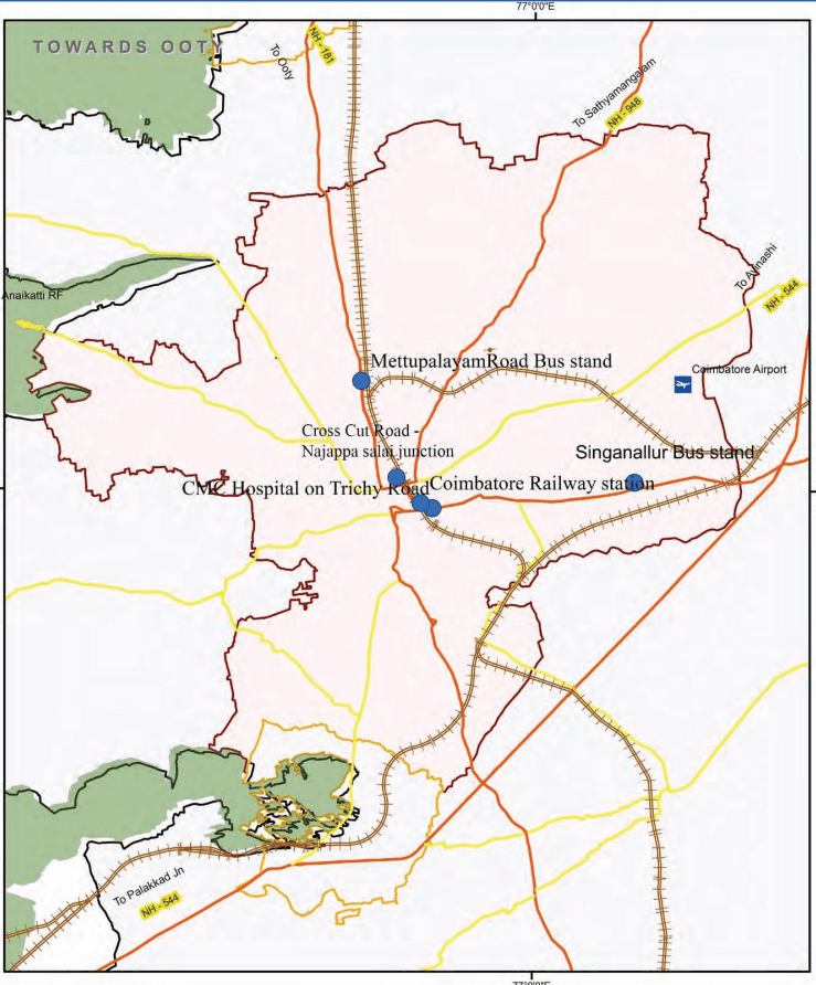
It has been observed that at few locations conflicts between pedestrians and vehicles are very frequent, due to heavy pedestrian and vehicular movement in the busy street of the city. There is a need for effective pedestrian crossing facilities at selected locations to ensure safety of pedestrians. The proposed Pedestrian Crossing Facilities in the study area is presented in Table 7.24.
Table 7.24Proposed Pedestrian Grade-Separators
SN
Location
Phasing
1
Cross-Cut Road - Dr. Nanjappa Road junction
Phase I
2
CMC Hospital on Trichy Road
3
Coimbatore Railway Station
4
Singanallur Bus Stand (Trichy Road)
5
Mettupalayam Road Bus Stand (Near Sai Baba colony)