The Tamil Nadu Town and Country Planning Act, 1971 provides a comprehensive framework for the systematic development and utilization of both rural and urban land across the state. This legislative framework facilitates the preparation and implementation of Master Plans to ensure planned growth and sustainable development.
The Master Plan encompasses various aspects of land use planning, infrastructure development, environmental conservation, and socio-economic advancement. The master plan may provide any or all of the following requirements:
• To determine how land in the planning area is used.
To allocate or reserve land for residential, commercial, industrial, and agricultural purposes, as well as for parks, playgrounds, and open spaces.
• To allocate or reserve land for public buildings, institutions, and civic amenities.
To make provisions for national highways, arterial roads, ring roads, major streets, railways, airports, canals, and other transportation links.
To outline traffic and transportation patterns, including road improvements and circulation systems.
To reserve for future development, expansion, and new housing projects.
To address improvements for poorly designed areas, outdated developments, slums, and population relocation wherever necessary.
Further to the above, the implementation of various other acts and regulations requires the master plan to provide for the following:
To ensure the provision of essential amenities, services, and utilities.
To make detailed development plans for specific zones, including housing, shopping centres, industries, civic facilities, and educational and cultural institutions.
• To regulate architectural features, building heights, number of floors, setbacks, open spaces, and land use.
To define the stages for implementing the Master Plan, and any other necessary matters, as required to be included.
To incorporate provisions for disaster management, including flood mitigation, cyclone-resistant infrastructure, earthquake-prone zone regulations, and emergency evacuation routes.
To allocate and protect water resources, including rivers, lakes, groundwater recharge zones, and watershed areas, ensuring sustainable usage and prevent pollution.
To include provisions for critical social infrastructure such as hospitals, community centres, and welfare institutions to cater to the needs of the population.
To address the development and maintenance of physical infrastructure, including water supply and sewage systems, stormwater drainage, solid waste management, and power supply networks.
The Urban and Regional Development Plans Formulation & Implementation (URDPFI) 2015 guidelines, formulated by the Town & Country Planning Organisation, Government of India provides guidelines for preparation of Master Plan inter-alia indicate:
The Master Plan (Development Plan) shall aim to provide detailed strategies and physical proposals to implement policies from the Perspective Plan and Regional Plan, based on economic and social needs, public aspirations, available resources, and priorities.
• To ensure affordable housing provisions and slum rehabilitation, as equitable access to shelter ensures inclusive urban growth.
1.3 Need for Master Plan
The Master Plan also identifies areas that need preservation, conservation, and development, particularly those with ecological value, natural scenery, and significant landscapes.
• It includes the protection of historical, architectural, and scientifically important structures, as well as environmentally sensitive areas.
The Master Plan will be prepared using Geographic Information System (GIS)-based mapping and spatial analysis to ensure accurate land-use planning, infrastructure management, and data-driven decision-making. The typical timeframe for these plans is 20-30 years, with phased planning in 5-year intervals for periodic reviews.
Coimbatore, known as the “Manchester of South India,” has a strong industrial legacy, particularly in textiles, and has evolved into a major hub for manufacturing, IT, and education. The city is also enriched with natural resources, including the Western Ghats, protected forests, and interconnected lakes, which are vital to its ecosystem. However, with rapid urbanization, industrial growth, and ecological sensitivity, a vision for stretgic development is essential
The existing Coimbatore Master Plan, approved in 1994, was formulated with a proposed land use plan for 2011. Since its horizon period is attained and the LPA encompassing the various Urban Local bodies such as Coimbatore Corporation and other municipalities, has undergone significant urban expansion, there is a need to update the master plan. The revised plan must regulate and facilitate growth while ensuring environmental sustainability and public welfare. Additionally, the planning area was expanded from 1,286.80 sq. km to 1,531.57 sq. km as per the G.O. (Ms) No. 188, H&UD Department, dated 25.10.2022, addressing the increasing developmental demands.
With the upcoming establishment of an Urban Development Authority (UDA) for Coimbatore, a comprehensive master plan will be crucial in guiding future development, implementing strategic policies, and fostering a balanced urban ecosystem. The new master plan aims to promote sustainable growth, inclusive development, and an enhanced quality of life for its residents while integrating ecological conservation and modern infrastructure.
1.4 Master Plan for Coimbatore LPA
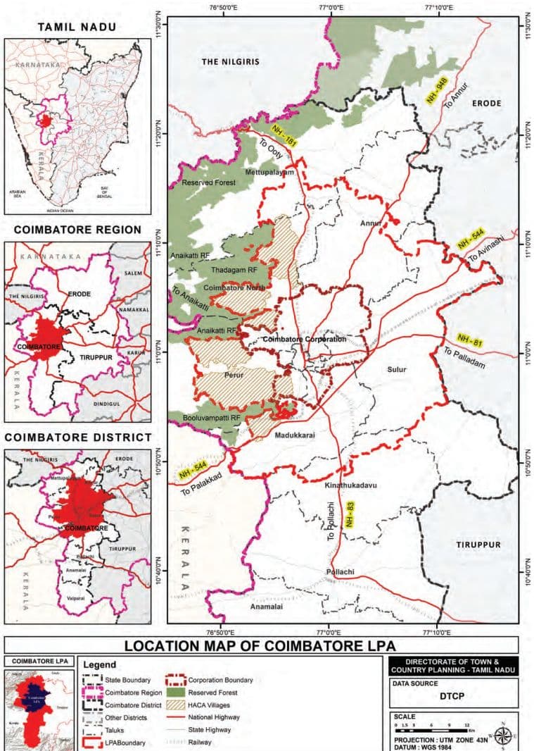
The Coimbatore Local Planning Area i.e. the city and its influence area considered for planning purpose was first delineated in 1974 comprising the Coimbatore Municipality and 45 Revenue villages of Palladam Taluk of area 593.45 sq.km. However, by a subsequent notification in 1980 the Coimbatore planning area or the Local planning area was revised to cover a larger area comprising the Coimbatore Corporation, Madukkarai Township, 31 Town Panchayats and 55 Revenue villages and was notified by G.O.(Ms.) No.503 H&UD Dept. dated 17.04.1980. The expanded area was 1287 sq.km. Separately, Kurichi, located adjacent to Coimbatore Local Planning Area was identified for development as a New Town and the area comprising Kurichi, Malumichampatti and Seerapalayam of 47.97sq.km was declared as Kurichi New Town planning area in G.O.(Ms.) No.494 H&UD Dept. dated 19.06.1983. More than a decade later the first Master Plan for Coimbatore as well as the Kurichi New Town Development plan were prepared and approved in 1994 and 1995 respectively. DTCP has prepared and approved 60 Detailed Development Plans during the period from 1974 to 2012 for different areas within the LPA. Historically, 11 Town Planning Schemes were prepared and approved from 1933 to 1972.
The Second Master Plan was initiated with an expanded jurisdiction, incorporating additional villages in Coimbatore District under Section 10(1) of the Act, as per G.O. (Ms) No. 41, H&UD Department, dated 26.02.2014. This extended the planning area to include 1 Corporation, 4 Municipalities, 21 Town Panchayats, and 66 revenue villages. The Coimbatore Local Planning Area (LPA) was officially declared under Section 10(4) of the T&CP Act, 1971, through G.O. (Ms) No. 188, H&UD Department, dated 25.10.2022, expanding its jurisdiction to 1,531.57 sq. km, covering eight taluks of Coimbatore District viz., Coimbatore North, Coimbatore South, Annur, Sulur, Kinathukadavu, Madukkarai, Perur, and Mettupalayam. Summary of the administrative boundary of Coimbatore LPA is detailed in Table 1.1.
1.7 Master Plan Preparation of 2021 – 2041
1.5 Urban Development Authority (UDA)
1.6 Hill Area Conservation Authority (HACA)
| S. Administrative | No. of. | Area |
|---|---|---|
| No Category | Local Bodies | (in Sq. Km) |
| 1. Corporation | 1 | 257.81 |
| 2. Municipalities | 4 | 97.56 |
| 3. Town panchayats | 21 | 314.93 |
| 4. Revenue Villages | 66 | 861.27 |
| Overall LPA | 92 | 1,531.57 |
The Coimbatore Urban Development Authority (UDA) was established with the jurisdiction of the same LPA boundary as per G.O. (Ms) No. 197, H&UD Department, dated 11.11.2022. This enables the seamless integration of planning and development functions. The UDA is expected to utilize the Master Plan as its primary tool for guiding sustainable urban growth, optimizing land utilization, and implementing strategic infrastructure development while addressing critical aspects such as transportation networks, environmental sustainability, and equitable distribution of civic amenities across the entire UDA area.
The Tamil Nadu Government established the Hill Area Conservation Authority (HACA) to protect ecologically sensitive hill areas and promote sustainable development. As per GO MS.No.44 (02.04.1990), unchecked activities like farming, tourism, and infrastructure in the Western Ghats have caused severe environmental concerns. While these developments benefit society, they strain fragile hill ecosystems. The Government recognized that hill areas need special policies, different from the plains, to prevent irreversible damage. HACA regulates development to ensure balance growth and conservation.
Since 17 villages in the Coimbatore LPA (Local Planning Area) fall under HACA, their ecological sensitivity is considered during the Master Plan preparation process to ensure sustainable development.
The Directorate of Town & Country Planning (DTCP), Government of Tamil Nadu, has undertaken the preparation of the Master Plan for Coimbatore Local Planning Area
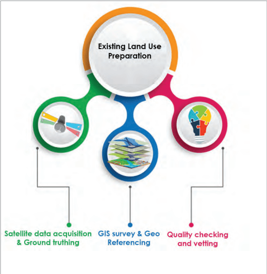
(LPA) as part of its state wide urban planning initiative. The Directorate, Coimbatore Region, has directly overseen all technical studies, surveys, and stakeholder consultations in accordance with the Tamil Nadu Town and Country Planning Act, 1971, and relevant urban development guidelines. The planning process includes comprehensive land-use assessments, infrastructure evaluations, transportation studies, and environmental considerations, supported by GIS-based spatial analysis and ground verification. Stakeholder discussions and inter-departmental coordination ensure inclusive and sustainable planning. DTCP plays a crucial role in Coimbatore’s urban development by consolidating data, preparing draft proposals, and contributing to the finalization of the Master Plan that guides the city’s structured growth.
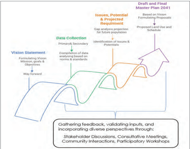
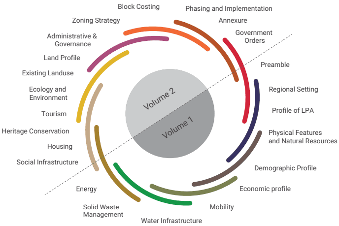
Figure 1.1: Methodology