To accommodate the commercial space demand, land must be allocated in appropriate use zones in accordance with planning norms and prevailing FSI provisions.
6.7.1 Applicable Land Use Zones
Commercial Zones: Core urban nodes and emerging business districts
Mixed Use Zones: Along major arterial roads and public transit corridors
Special Commercial Corridors: Designated retail streets, integrated township hubs
6.7.2 Estimated Land Requirement (2041) for all scenarios
Table 6.14Estimated Land Requirement for Commercial Space - 2041
S. No
Scenarios
Total commercial space required (in million sq.ft)
FSI
Total land area required (in sq.ft)
Total land area required (in sq.km)
1
Business as usual (BAU)
5.20
2.0
26,01,103
0.24
2
High growth trajectory (HGT)
6.20
3.0
20,65,866
0.19
3
Aspirational growth (AG)
8.84
4.0
22,09,875
0.21
6.10Goals for 2041
6.10.1 Goal 1: Position Coimbatore as a Globally Competitive Economic Powerhouse
Coimbatore’s economy thrives on its resilient industrial ecosystem and growing tertiary sector, led by real estate and MSMEs in industries like engineering and auto components.
To position Coimbatore as a globally competitive economic powerhouse and ensure a thriving economy with sustained future growth, the following strategies have been proposed:
6.10.1.1 Strategy 1: Develop Ready-to-Use Industrial Infrastructure to Accelerate Market Entry and Attract Investments
To position Coimbatore as a globally competitive major manufacturing hub, the development of robust industrial infrastructure, including flexible workspaces, plug-and-play industrial parks, and rental factory shells, is essential. Modular rental factory shells, ready for lease to startups and MSMEs can significantly reduce the typical 15–18 month timeline for setting up manufacturing units, thereby enabling faster market entry for companies and improving ease of doing business. These facilities not only enhance the attractiveness of Coimbatore for new investments but can also improve project Net Present Value (NPV) by an estimated 10–12% (Source: Trillion Dollar Economy Report). The facilities ensure adequate and affordable space for startups and MSMEs to thrive, protecting them from cost pressures and enabling a diverse, resilient economy.
6.10.1.2 Strategy 2:Promote Medium Industries as Drivers of Scalable Growth, Quality Employment, and Export Competitiveness
Strengthen Coimbatore’s medium industry ecosystem to unlock its high potential for formal, and better-quality employment. Medium enterprises are better capitalized, more likely to adopt digital systems, and capable of meeting export standards due to their investments in R&D, automation, and quality. Their growth also fuels demand for micro firms in services like packaging, logistics, and maintenance, reinforcing the local industrial value chain.
Medium industries act as a bridge between small businesses and large corporations, bolstering supply chains and contributing to regional economic resilience. In the Coimbatore context, promoting medium industries through targeted infrastructure, improved credit access, and strong market linkages can position them as key enablers of balanced growth, innovation, and competitiveness— supporting the region’s vision for 2041.
6.10.1.3 Strategy 3: Strengthen Local Retail Clusters and Enable Mixed-Use Development for a Sustainable and Inclusive Economy
Foster locally significant clusters such as street markets and neighbourhood businesses to build a successful, competitive, and diverse retail sector that ensures sustainable access to goods and services. Additionally, allowing small-scale commercial and production activities within residential zones can reduce commute costs, support local entrepreneurship, and enhance employment opportunities within communities.
6.10.1.4 Strategy 4: Promote Private Sector Participation in Industrial and IT Park Development
Encourage leading private industrial and IT park developers such as Mahindra, DLF, and Mindspace to invest in the development of industrial infrastructure in Coimbatore, either independently or through strategic partnerships with TIDCO
Offer a package of incentives including fast-track approvals, subsidized land rates through industrial estates, infrastructure support (power, water, roads), and fiscal incentives such as tax rebates or capital subsidies such as the provision in industrial policies. Introduce a “Single Window Cell” for private park developers to streamline coordination and reduce entry barriers.
6.10.1.5 Strategy 5: Integrate Sector-Specific Skill Development Hubs into the Master Plan.
Embed the development of sector-specific training institutes within the city’s master planning framework to ensure alignment between industrial growth nodes and skill development infrastructure.
Designate land parcels within or near industrial and IT park clusters specifically for training and skilling institutes, ensuring proximity to relevant industries.
Facilitate partnerships between government agencies (e.g., TIDCO, SIPCOT) and private industry stakeholders to co-create curriculum, share training infrastructure, and offer apprenticeships. Enable academia industry linkages by taking the support of agencies like SIPCOT, TIDCO, CII, etc.
6.10.1.6 Strategy 6: Implement Digitally Enabled Land Management for Economic Growth
Adopt GIS-based digital land management systems to streamline land utilization, improve transparency, and accelerate industrial and commercial development through data-driven planning and investor-friendly services.
Real-Time Land Monitoring: Use GIS tools to continuously track land usage patterns and assess the health and capacity of industrial clusters for better planning and intervention.
Online Land Availability Dashboard: Develop an interactive public platform showcasing available government-owned “plug-and-play” industrial spaces and rental factory shells, complete with infrastructure status and connectivity details.
Integrated Approvals: Link the GIS system with the single-window portal to enable end-to-end online processes for land leasing, approvals, and clearances, reducing turnaround time for investors.
8FinTech & Digital Financial Services
Structured incentives for large FinTech firms.
75% reimbursement on operational expenses.
EPF subsidies for core FinTech design/software staff.
Tier 2 multiplier of 1.5x for Coimbatore.
Coimbatore Opportunity:
Large base of NBFCs, regional banks, and cooperative institutions open to digitization.
Nascent ecosystem of financial innovation at Forge and PSG iTech.
6.5 Economic Growth Strategy
6.5.1 Economic Growth Scenarios
As part of long-term planning for Coimbatore Local Planning Area (LPA), population projections have been modelled under three distinct scenarios—Business as Usual (BAU), High Growth Trajectory (HGT), and Aspirational Growth (AG). These scenarios reflect varying levels of implementation of proposals outlined in this Master Plan, including infrastructure investments, regulatory reforms, economic strategies, and sustainability initiatives.
Table 6.5Growth Scenarios
S. No
Scenarios
Projected population (2021)
Compound annual growth rate (CAGR)
Projected population(2041)
1
Business as usual (BAU)
31,62,392
3.07%
58,24,706
2
High growth trajectory (HGT)
3.50%
62,92,492
3
Aspirational growth (AG)
4.50%
76,26,785
6.5.1.1 Scenario 1: Business as Usual (BAU)
This scenario assumes a continuation of historical trends. The Compound Annual Growth Rate (CAGR) remains at 3.07%, consistent with the observed population growth between 2011 and 2041. Growth continues to be driven by existing economic strengths—MSMEs, textile industries, education, and health—but without significant structural transformation.
6.5.1.2 Scenario 2: High Growth Trajectory (HGT)
The High Growth Trajectory scenario anticipates moderate to full implementation of key Master Plan proposals, including the Coimbatore metro rail, ring road network, corridor-based development, and urban housing projects. With improved regional connectivity and business climate, the CAGR increases to 3.5%. This scenario envisions Coimbatore strengthening its role as a regional economic hub, attracting higher levels of skilled migration and private investment, particularly in IT/ITES, logistics, and engineering sectors.
6.5.1.3 Scenario 3: Aspirational Growth (AG)
This scenario reflects ambitious and time-bound implementation of transformative proposals in the Master Plan. The city evolves into a Tier-1 alternative and most attractive state investment destination, supported by proactive governance, high-quality infrastructure, and global partnerships. The CAGR is assumed at 4.5%, capturing largescale in-migration, expansion of high-value sectors.
6.5.2 Enabling Service Sector Growth in Coimbatore LPA
Coimbatore is envisioned as a lighthouse city for the emerging services economy, with a strategic focus on transitioning into a hub for start-ups, innovation, and knowledge-based industries. In line with this objective, the service sector is anticipated to play a pivotal role in shaping the city’s economic and spatial trajectory. The Coimbatore Local Planning Area (LPA), therefore, requires an integrated approach to estimate and accommodate workforce demand and associated spatial requirements for the service sector.
6.5.2.1 Methodology for Estimating Workforce and Space Requirements under the Business-as-Usual Scenario
A quantitative approach was adopted based on decadal population projections, labour force participation assumptions, sectoral employment distributions, and Formal work space norms.
6.5.2.2 Assumptions and Parameters - all scenarios
Table 6.6Assumptions and Parameters - all scenarios
S. No
Scenarios
Working population share (Smart city norms)
Share employed in non-retail commercial (NITI Aayog)
Share requiring formal office space (based on the nature of of the proposed economic activity)
External workforce requiring formal office space (floating population from other districts Tiruppur, Erode, Karur etc)
1
Business as usual (BAU)
60%
50%
35%
10%
2
High growth trajectory (HGT)
65%
55%
40%
12%
3
Aspirational growth (AG)
70%
60%
45%
15%
(Note: Incremental (decadal) population is used as a base to project new demand. It represents the additional population entering the workforce ecosystem – either through natural growth or migration – and directly influences the need for employment generation and supporting infrastructure.)
6.5.2.3 Workforce and Work Space Demand Projections – all scenarios
Table 6.7Space Demand Projections - all scenarios
S. No
Scenarios
Total workforce required(2041)
6.5.3 Land Use Translation
To accommodate the net workspace gap for service sector, land must be allocated and regulated within the following use zones:
6.5.3.1 Applicable Land Use Zones
Commercial Zones: Central Business Districts and sub-centres
Mixed Use Zones: Along arterial corridors, TOD areas
IT/ITES Parks and SEZs: Designated enclaves for technology and process-driven enterprises
6.5.3.2 Estimated Land Requirement (2041)
Table 6.8Estimated Land Requirement for office space - 2041
S. No
Scenarios
Total office space required (in million sq.ft)
FSI
Total land area required (in sq.ft)
Total land area required (in sq.km)
1
Business as usual (BAU)
50.72
2.5
2,02,88,604
1.88
2
High growth trajectory (HGT)
83.21
4.0
2,08,02,412
1.93
3
Aspirational growth (AG)
160.88
4.0
4,02,19,718
3.74
6.5.4 Enabling Advanced Secondary Sectors Growth in Coimbatore LPA
Coimbatore’s legacy as one of South India’s premier industrial cities will form the backbone of its transition into an advanced manufacturing and industrial innovation hub. With the rise of automation, robotics, clean technologies, and deep-tech industrial applications, Coimbatore is strategically positioned to emerge as a Tier-2 epicentre for future-ready secondary sector activities.
The Coimbatore Local Planning Area (LPA), with its robust base of MSMEs, engineering colleges, and industrial parks, needs to strengthen and modernize its secondary sector by fostering high-value, clean, and scalable production ecosystems. These sectors are expected to significantly contribute to employment generation, export growth, and increased demand for specialized industrial space.
6.5.4.1 Methodology for Estimating Workforce and Space Requirements under the Business-as-Usual Scenario
6.5.4.2 Assumptions and Parameters
Table 6.9Estimated Land Requirement - 2041
S. No
Scenarios
Working population share (Smart city norms)
Share requiring flatted factory space (NITI Aayog)
External workforce requiring flatted factor space (floating population from other districts Tiruppur, Erode, Karur etc)
1
Business as usual (BAU)
60%
30%
25%
2
High growth trajectory (HGT)
62%
35%
30%
3
Aspirational growth (AG)
65%
40%
35%
(Note: Incremental (decadal) population is used as a base to project new demand. It represents the additional population entering the workforce ecosystem – either through natural growth or migration – and directly influences the need for employment generation and supporting infrastructure.)
6.5.4.3 Workforce and Work Space Demand Projections – Business as Usual
Table 6.10Work Space Demand Projections for Industries
S. No
Scenarios
Total workforce required (2041)
Per Capita Flatted factory space (in sq.ft)
Additional buffer on space on existing floor space (in %)
6.10.3Goal 3: Enable Compact, Connected, and Efficient Urban Growth through Strategic Land Use Planning
6.10.3.1 Strategy 1: Relocation of Industries for Balanced Urban Growth
Relocate industries from congested urban cores to modern, infrastructure-ready industrial zones such as plug and play parks and flatted factories to improve efficiency, reduce pollution, and unlock high-value urban redevelopment.
Encourage cluster-based relocation for complementary industries.
Allotment of ready plots and flatted factory spaces in designated zones.
6.10.3.2 Strategy 2: Land Optimization & Corridor-Based Intensification
Enable Intensified Floorspace in Key Zones:
Incentivize higher FSI/FAR in both brownfield and greenfield sites to support vertical growth, reduce land costs per sq.ft., and attract investment. Area-specific micro-level plans will explore innovative approaches to maximize landuse efficiency.
Promote Vertical Industrial Development:
Support vertical zoning, flatted factories, and basement additions in industrial areas to maximize land productivity while mitigating infrastructure strain.
Implement Transit-Oriented Development (TOD):
Design compact, mixed-use development along metro corridors and IT corridors, with smaller block sizes and integrated public spaces to prevent urban sprawl.
Designate MSME Growth Corridor and Clusters:
Develop a dedicated MSME corridor along the eastern section of the Outer Ring Road, providing highdensity, infrastructure-ready industrial clusters with easy logistics access.
6.10.3.3 Strategy 3: Development of Integrated Economic Clusters & Job Centers:
Establish strategic economic clusters with mixeduse development—integrating residential, commercial, and essential infrastructure—to improve quality of life, optimize supply chain, reduce commute times, and lower operational costs. Encourage co-location of complementary industries to foster innovation, supply chain efficiency, and collaborative growth.
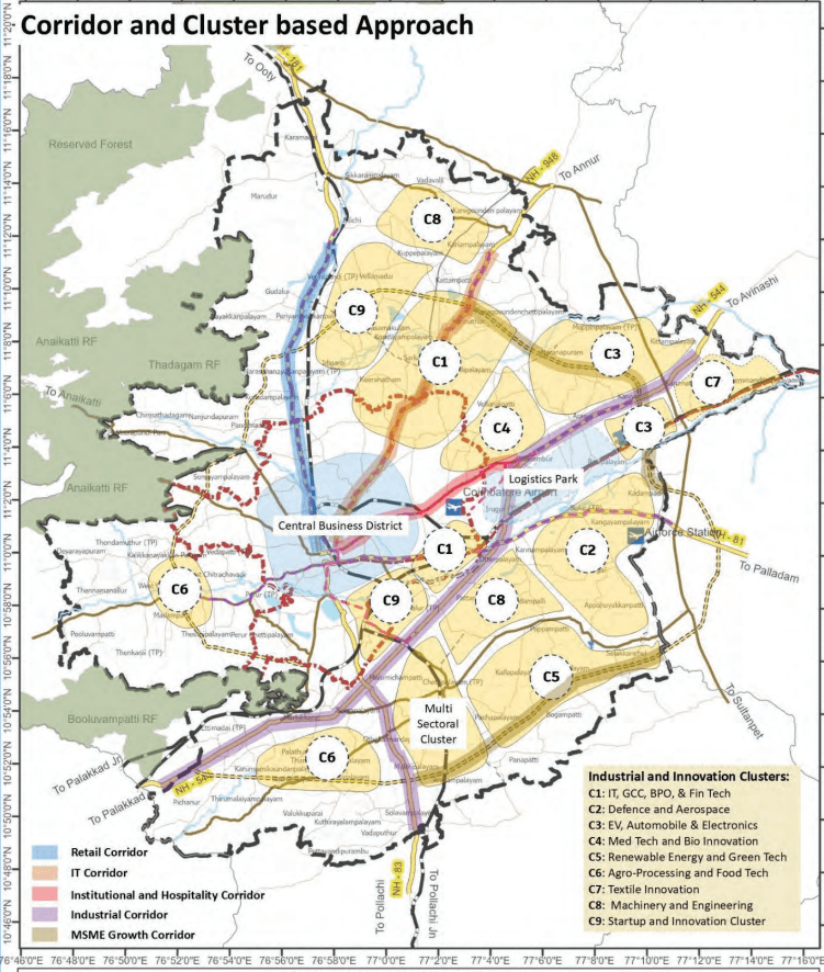
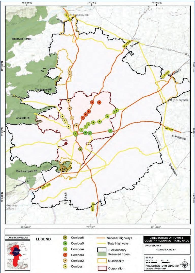
Additional corridors for economic growth have been identified based on existing development patterns and predominant land uses they are intended to serve. These corridors, which also function as major transit routes, present opportunities for further densification to support and accommodate future urban growth through mixeduse development.
The proposals have been formulated with consideration of public feedback, stakeholder recommendations, and the region’s overall connectivity, ensuring that the development framework is inclusive, well-integrated, and future-ready.
Retail Corridor: Mettupalayam Road - Retail corridor has been identified along Mettupalayam Road, encompassing areas such as RS Puram, Thudiyalur, and Narasimmanaickenpalayam, based on observed growth trends. This corridor also includes integrated townships, which hold potential for future transformation into mixeduse developments.
IT Corridor - Sathyamangalam Road - IT corridor has been identified along Sathy Road, covering key areas such as Ganapathy, Saravanampatti, and Kurumbapalayam, based on existing development patterns and emerging growth trends. The corridor is witnessing the development of several upcoming IT parks, which are expected to act as major catalysts for economic activity and employment generation. Additionally, the presence of integrated townships in this stretch offers significant
potential for future transformation into vibrant mixed-use developments.
Institutional and Hospitality Corridor- Avinashi Road - Institutional and Hospitality Corridor has been identified along Avinashi Road, anchored by the presence of prominent schools, higher education institutions, and a range of hospitality establishments. The corridor benefits from its strategic proximity to the Coimbatore International Airport, enhancing its accessibility. This area holds significant potential for further expansion as a hub for education, healthcare, business travel, and hospitality services.
Industrial Corridor - L & T Bypass & Pollachi Road - Industrial Corridor has been identified along L&T Bypass and Pollachi Road, driven by strong regional connectivity, the extension of the Chennai–Bengaluru Industrial Corridor (CBIC) until Kochi, and ample land availability. This corridor is already witnessing industrial growth, supported by favorable infrastructure and accessibility. With its strategic location and potential for large-scale developments, the corridor is well-positioned to attract manufacturing, logistics, and allied industries, making it a key zone for future industrial expansion in the region.
MSME Growth Corridor - Proposed Ring Road - MSME Growth Corridor has been identified along the eastern segment of the proposed Ring Road, leveraging its strategic connectivity to major arterial and sub-arterial roads across the city. This corridor is poised for highdensity development, offering significant advantages in terms of logistics and mobility—key enablers for the growth of Micro, Small, and Medium Enterprises (MSMEs). The availability of contiguous land parcels and improved infrastructure makes this area particularly suitable for the establishment of flatted factory complexes, plug and play parks, allowing efficient use of space and shared amenities. This corridor presents a strong opportunity for cluster-based development, fostering innovation, entrepreneurship, and job creation within the MSME ecosystem.
COIMBATORE LPA
LEGEND
DIRECTORATE OF TOWN &COUNTRY PLANNING - TAMIL NADU
Reserved Forest
Airport
RRTS
DATA SOURCE
Rivers
Logistics Park
0
LPABoundary
CBE_Dist_Combined_D2
SymbolID
CorporationBoundary
Adminboundary
0
Railway Line
Proposed Roads
1
National Highways
RoadNetwork_NH_SH_
2
State Highways
Proposed Ring road
Tanks
Map 6 10: Proposed Cluster Map
Proposed Clusters
Cluster 1: IT, GCC, BPO, & FinTech
This cluster is strategically located along Sathy Road, identified based on existing IT development, availability of land for future expansion, and a favorable business environment. The area boasts excellent road connectivity and is well-served by public transport, further enhanced by the upcoming Coimbatore Metro Corridor, which will significantly improve accessibility and mobility for both the workforce and enterprises.
Its proximity to Coimbatore International Airport adds to its appeal for Global Capability Centers (GCCs), BPOs, and FinTech companies, offering efficient regional and national connectivity. The corridor is already witnessing steady growth in IT and tech-based enterprises, supported by a strong local talent pool.
In addition, the presence of premier educational institutions such as Kumaraguru College of Technology, PSG College of Technology, and SNS College provides a consistent pipeline of skilled professionals, strengthening the cluster’s potential as a hub for IT and knowledgebased industries.
C2: Defence and Aerospace
This cluster is emerging as a strategic hub for Defence and Aerospace industries, anchored by the Tamil Nadu Defence Industrial Corridor and the SIPCOT–TIDCO Defence Park. It is well-connected to key transport infrastructure, including the L&T Bypass and the proposed Ring Road, enabling efficient movement of goods, components, and personnel.
A major advantage of this cluster is its proximity to Sulur Air Force Station—one of the largest and most critical air bases in Southern India—which significantly enhances its strategic relevance for defence and aerospace manufacturing, testing, and support services. Additionally, its closeness to Coimbatore International Airport supports both commercial and cargo aviation requirements.
The area also benefits from the presence of upcoming aviation training and research institutions, ensuring a steady pipeline of skilled talent tailored to industry needs. With strong infrastructure, policy support, and locational advantages, this cluster is poised to become a key node in the national defence and aerospace ecosystem.
C3: EV, Automobile & Electronics
This cluster is proposed near villages such as Arasur, Mopperipalayam, Karumathampatti, strategically positioned to support the growth of Electric Vehicles (EVs), Automobile, and Electronics industries. The location benefits from excellent connectivity to both the L&T Bypass and the proposed Ring Road, facilitating efficient movement of raw materials and finished goods across regional and national markets.
Its close proximity to the upcoming Logistics Park and Coimbatore International Airport provides a strong advantage for exports, especially for high-value and time-sensitive components. The area also includes existing industrial estates with available vacant plots, offering ready-to-develop land parcels ideal for quick establishment and scaling of operations.
With a growing ecosystem for advanced manufacturing and clean technologies, along with supportive infrastructure and connectivity, this cluster near Karumathampatti is poised to become a significant hub for EV production, auto components, and electronic manufacturing in the region.
C4: Med Tech and Bio Innovation
Proposed along Avinashi Road in Mylampatti and Neelambur, this cluster leverages the presence of leading medical institutions and hospitals, offering a strong base for Med Tech, biotechnology, and healthcare innovation. Supported by an existing talent pool and proximity to medical colleges and research centers, the area is wellconnected to the city and benefits from the upcoming metro corridor.
The cluster presents opportunities for academy industry collaboration with hospitals, academic institutions, and startups, enabling clinical research, product development, and Med Tech manufacturing—positioning it as a key node in Coimbatore’s healthcare and bio-innovation ecosystem.
C5: Renewable Energy and Green Tech
Proposed in villages such as Kallapalayam, Bogampatti, and Pappampatti, this cluster is strategically located near established wind farms along Pollachi and Palladam, making it ideal for renewable energy and green technology initiatives.
The presence of existing industrial estates, including CODISSIA Industrial Estate and Kallapalayam, with available vacant plots, supports immediate development. The area is well-connected via the Ring Road and State Highways, ensuring efficient logistics and accessibility.
With access to natural resources, industrial infrastructure, and growing demand for sustainable solutions, this cluster is poised to become a hub for clean energy manufacturing, green tech R&D, and sustainable industrial practices.
C6: Agro-Processing and Food Tech
Food processing hubs are proposed in the western and south western part of the planning area, particularly in villages such as Palathurai, Arisipalayam, Madampatti and Chitrachavadi, leveraging their proximity to agricultural lands and dairy farms. These locations offer access to raw materials, making them ideal for setting up processing units, packaging centers, and value-added agri-product facilities.
The presence of active dairy farming in these areas also significantly contributes to the primary sector economy, supporting livelihoods and offering opportunities for integrated dairy processing and allied industries.
To support the supply chain, a network of cold storage facilities is recommended, ensuring preservation, reducing post-harvest losses, and improving market access.
With strong agricultural linkages and growing demand for processed food products, this cluster is well-positioned to evolve into a key Agri-Tech and food value chain hub.
C7: Textile Innovation
While the textile industry in Coimbatore has seen a decline due to rising regional competition, the city still holds strong potential to re-emerge as a hub for R&D, innovation, and advanced textile technologies. This cluster is proposed
on the eastern side of the planning area, strategically positioned closer to the Tiruppur region, which remains a leading textile manufacturing zone.
The location benefits from excellent logistics connectivity through the L&T Bypass and State Highways, enabling efficient movement of goods and collaboration across textile value chains.
C8: Machinery and Engineering
This cluster is proposed in two key locations—one closer to the city and another on the periphery of the planning area, particularly along Sathy Road and the L&T Bypass. These areas have long supported Coimbatore’s reputation as a hub for machinery, pumpset manufacturing, and precision engineering industries.
cluster aims to strengthen Coimbatore’s legacy in mechanical innovation, while encouraging modernization through automation, advanced manufacturing technologies, and export-oriented production.
With established industrial ecosystems and access to both city services and logistics networks, this cluster is well-positioned to drive growth in the engineering and industrial machinery sectors.
C9: Startup and Innovation Cluster
This cluster is proposed in two strategic locations— one along Mettupalayam Road and Ring Road in Periyamaichenkpalayam and Veerpandi, and the other near the L&T Bypass and Pollachi Road, within the corporation limits. The aim is to foster Coimbatore as a leading startup hub, providing the necessary infrastructure, innovation spaces, and access to resources for entrepreneurs, tech startups, and innovative businesses.
The cluster will create an ecosystem for technologydriven innovation, featuring co-working spaces such as Mudhalvar Padaipagam, incubators, accelerators, and venture capitl access. Its proximity to major transport corridors ensures seamless connectivity for businesses and talent, facilitating market and logistical access. By combining modern infrastructure with entrepreneurial support, this cluster aims to establish Coimbatore as a thriving startup hub, attracting both domestic and international innovation ventures.
6.10.4Goal 4: Resilient and Sustainable Measures to Power Long Term Economic Growth
In order to ensure sustained economic growth, there exists a need for increasing high-paying jobs, especially in the service sector.
6.10.4.1 Strategy 1: Workforce Alignment and Inclusive Skill Development
Establish a dynamic skills and employment database for the Local Planning Area (LPA) through initiatives like Naan Mudhalvan to align talent with industry needs. Prioritize increasing female workforce participation to meet and exceed national and global benchmarks, fostering inclusive and balanced economic growth.
6.10.4.2 Strategy 2: Integrate Social and Recreational Infrastructure into Cluster Development
Ensure equitable access to social and recreational amenities in all proposed economic and residential clusters through micro-level planning tools such as Land Pooling and Local Area Plans, fostering inclusive, livable, and vibrant communities.
Mandate or incentivize adherence to green building codes (like ECBC and Eco Niwas Samhita) for new industrial units and commercial developments.
Facilitate the transition to energy-efficient machinery, motors, lighting, and HVAC systems in small and medium enterprises through subsidies, shared facilities, and technical support.
Pilot smart grid systems in large industrial estates with real-time monitoring, demand response features, and time-of-day tariffs to reduce peak consumption and improve efficiency.
Offer financial assistance or low-interest loans for upgrading older industrial buildings.
6.10.5Strategic Actions
6.10.5.1 IT & Ites
Establish a Semiconductor Component Hub within the ELCOT IT Park or a new SIPCOT zone.
Create a chip design and IP innovation cluster tied to IIT-Madras Research Park collaborations
Introduce a skill certification program on VLSI, SoC design, and microelectronics.
6.10.5.2 Logistics
Develop a Multimodal Logistics Park near Sulur/ Karanampettai linked to the Western Bypass.
Enable EV-based last-mile logistics zones around industrial corridors.
Establish a Textile Export Logistics Hub integrated with inland container depots (ICDs) and rail links.
6.10.5.3 Formalize a Coimbatore Aero Cluster with tiered vendor certification systems.
Incentivize joint ventures with DPSUs and global OEMs via SIPCOT incentives.
Promote aerospace tooling and additive manufacturing innovation zones.
6.10.5.4 TIDEL Parks
● Allocate land for a Data Center Park near TIDEL Park Phase II or Avinashi Road corridor.
Mandate solar integration and water recycling for green certification.
Attract cloud and gaming infra firms with reliability benchmarks and expedited clearances.
6.10.5.5 Msme
Designate a Start-up Innovation District with access to prototyping labs, co-working, and cloud credits.
Launch a Coimbatore City Challenge Fund for civic-tech, health, and mobility start-ups.
Facilitate reverse pitching by MSMEs to solve sectorspecific innovation challenges.
6.10.5.6 Esdm
Expand the existing SIPCOT zone to house ESDM-exclusive plots.
Launch MSME-led contract manufacturing consortiums to pool infrastructure.
Setup an ESDM certification and quality lab within the industrial cluster.
6.10.5.7 EV
Attract EV drivetrain manufacturers by offering plug-and-play plots.
Establish a Lightweight Materials Research Hub with DRDO/IIT linkages.
Promote supplier diversification to global EV and hybrid vehicle markets.
6.10.5.8 FinTech
Build a Coimbatore FinTech Lab to test RegTech, AgriTech, and MSME lending models.
Facilitate API partnerships with NBFCs and cooperatives.
Promote women-led FinTech ventures with targeted incubation and sandboxing.
7.1 Introduction
7.2 Regional Linkages
A robust and integrated transportation plan influences economic development, population distribution and the shape of the city. Given Coimbatore’s role in industrial logistics and the need for daily commuting, strategic urban mobility interventions are necessary to ensure efficient movement of people and goods. It is vital for the sustainable development of the Coimbatore Local Planning Area (LPA).
As a prominent industrial and commercial hub in Tamil Nadu, Coimbatore has witnessed rapid urban growth, leading to increased vehicular traffic and evolving mobility demands. This has led to challenges such as traffic congestion, extended travel times, and a growing dependence on private vehicles. To address these issues, it is essential to provide an adequate, accessible and affordable Integrated Multi Modal Transport System to the people of this region to cater for the needs of the passengers and goods. Enhancing public transportation, strengthening non-motorized and last-mile connectivity, and implementing effective traffic management solutions are key priorities.
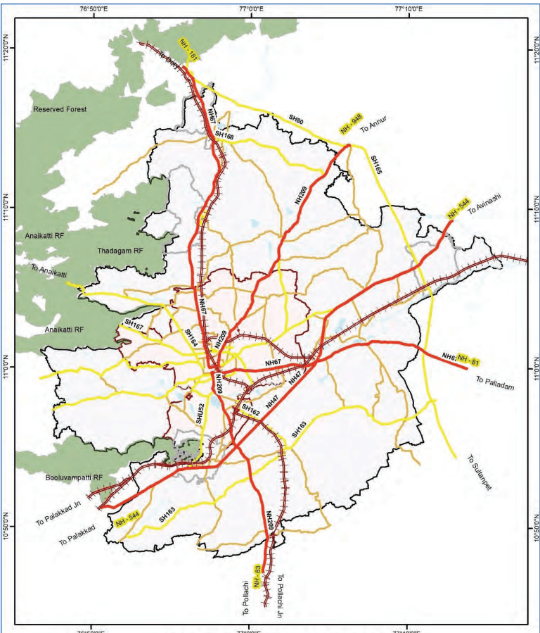
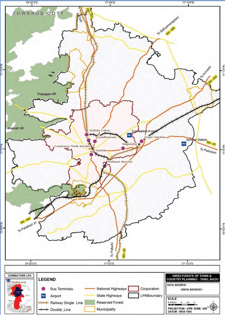
The Coimbatore city and LPA has radial network. The LPA region is connected by an extensive road, rail, and air network, serving as a major transportation hub linking cities like Chennai, Salem, Kochi, Trichy, Ooty, and Bangalore via NH-544, NH-81, NH-181, NH-948, and NH-83.
The Coimbatore LPA has a good regional rail connectivity for both passenger and freight movement having major stations at Coimbatore Junction, Coimbatore North, Podanur and Irugur and Peelamedu for freight movement. The region is served by the Coimbatore International Airport at Peelamedu which caters to domestic flights to major Indian cities and international flights.
7.3Existing Road Network
Coimbatore Local Planning Area (LPA) is structured with a radial road network, that consists of national highways, state highways, bypass roads and other roads to facilitate movement of passengers and goods.
NH-544 (Avinashi & Palakkad Roads): Links Coimbatore to Salem, Bengaluru, Chennai, and Kerala.
The Coimbatore Bypass Road (L&T Bypass) forms part of NH 544 and connects Neelambur to Madukkarai. It
connects between radial roads on the eastern and southern side of the city, namely, Avinashi Road, Trichy Road, Pollachi Road and Palakkad Road.
NH-81 (Trichy Road): Connects to Karur, Tiruchirapalli, and Nagapattinam.
NH-181 (Mettupalayam Road): Access to Ooty and the Nilgiris.
NH-948 (Sathyamangalam Road): Connects to Karnataka.
NH-83 (Pollachi Road): Connects to Palani and Dindigul.
However, Coimbatore lacks a complete ring road to connect all the radial roads of the city, and the increasing freight and passenger traffic volumes cause congestion and safety issues. The L&T Bypass Road is also congested as it continues to operate as a two-lane carriageway which is currently approaching capacity in the Base Year.
Map 7.1: Existing Major Road Network in Coimbatore LPA
COIMBATORE ROAD NETWORK
7.4 Existing Transport Systems
7.4.1 Rail Transport
Coimbatore Junction is the city’s primary railway station, providing direct connectivity to major cities across India. Stations such as Podanur, Peelamedu, Coimbatore North, and Mettupalayam cater to commuter and freight movement within the region, helping to reduce congestion in the city core. There is footfall of around 25 Million passengers per annum at all the railway stations of Coimbatore.
7.4.2Air Transport
Coimbatore International Airport, located in Peelamedu offers both domestic and international air connectivity. It links Coimbatore with cities like Chennai, Bengaluru, Mumbai, Delhi, and international destinations including Sharjah, Singapore, and Colombo. Coimbatore International Airport is the second largest airport in the state in terms of runway length, aircraft movement, passenger traffic and cargo after Chennai International Airport in Tamil Nadu. At present airport caters 30 Lakh passengers per annum and freight of 10,800 Tonnes per annum.
In terms of access to the airport, 67.1% of passengers use taxis, and 17.9% rely on cars, indicating a high dependence on motorized modes. The airport supports significant cargo movement—especially textiles, engineering goods, and perishables—and is undergoing expansion to improve terminals, cargo facilities, and runway infrastructure.
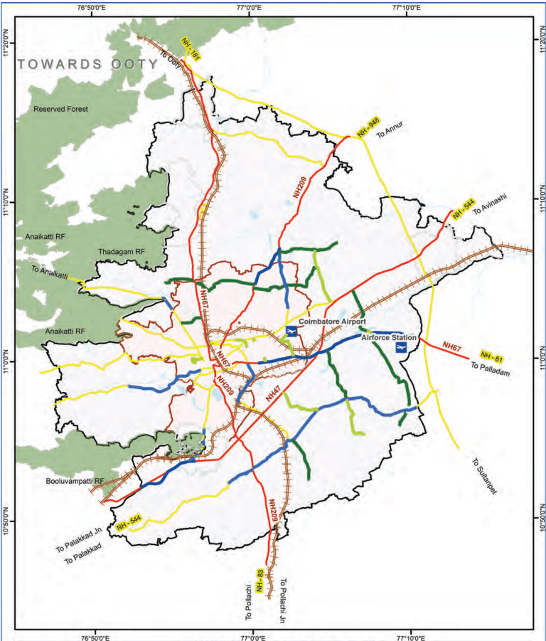
Map 7.2: Existing Transportation Network of Coimbatore LPA
7.4.4Intermediate Public Transport System
Intermediate Public Transit (IPT) is also known as Para Transit. IPT services such as auto-rickshaws, shared autos, taxis, and mini-vans play a critical role especially in areas underserved by formal public transport. There are 22,929 auto rickshaws and 792 taxis being operated by private operators. These services cater to approximately 2 lakh passengers daily, bridging the gap for those traveling between public transport points and their final destinations.
These services are concentrated around railway stations, major bus stands, commercial areas, industrial zones, educational institutions, residential suburbs, and key facilities like the airport and hospitals, characterized by fragmented and unorganized operations.
7.4.5NMT Facilities
NMT remains a key mode of transport for many in Coimbatore. NMT currently accounts for 20.8% of walk trips and 1.8% of cycle trips. However, the city lacks dedicated infrastructure for non-motorized vehicles (NMVs), forcing cyclists to share unsafe main carriageways on roads. Similarly, pedestrian infrastructure is inadequate, with poorly maintained or absent footpaths and unsafe road crossings, particularly in high-traffic areas such as Gopalapuram Road, Pollachi Main Road, Chetty Street, and Mettupalayam Road.
The absence of dedicated cycle lanes on major roads forces cyclists to navigate mixed traffic, heightening accident risks. Simultaneously, areas with heavy pedestrian and commercial activity like Gandhipuram, Ukkadam, and RS Puram suffer from encroachments and poorly maintained footpaths, undermining walkability.
A critical issue is the lack of safe pedestrian crossings and continuity along arterial streets, making walking both unsafe and inconvenient. Alarmingly, 98% of city roads lack proper footpaths, compelling pedestrians to walk on the carriageway, thereby increasing vulnerability and reducing overall urban safety and mobility.
7.4.6Road Safety
Road safety in Coimbatore has been a concern, primarily due to poor adherence to road design standards, lack of facilities for vulnerable road users – pedestrians (elderly, women, children and physically disabled) and motorcyclists, poor enforcement of safety devices such as helmets and seatbelts. This is in addition to the rapid increase in vehicle ownership and insufficient traffic management measures.
The number of accidents in last three years along with number of fatal and non-fatal accidents is given in table below.
Table 7.2Road Accident Statistics for Coimbatore City
YEAR
FATAL
NON-FATAL
2021
242
608
2022
316
967
2023
298
862
2024
281
895
2025 (Till 17th April2025)
85
268
Sources: City Traffic Police, Coimbatore
The key factors contributing to accidents in Coimbatore are:
Undivided roads leading to head-on collisions when vehicles overtake.
Intersection/junction design not compliant with standards and not indicating the priority road.
Missing or non-usable pedestrian infrastructure for crossing the road or for segregating traffic walking alongside the road.
Poor road marking, signage and street lighting to inform, warn, guide and control road users.
Non-compliance of helmets & seat belts to reduce injury severity in the event of a crash.
Notably, fatal accidents have been frequently reported at key radial corridors and junctions such as Racecourse, Singanallur, Ramanathapuram, Rathinapuri, Saravanampatti, Kattoor, and Peelamedu, highlighting the urgent need for targeted safety interventions at these locations.
7.4.3Public Transport System
Currently, city buses are the only mass transit option, highlighting the need for a more efficient, integrated, and sustainable system. As the city expands rapidly, enhancing public transport can ease congestion, reduce reliance on private vehicles, and ensure accessible, seamless commuting for all.
7.4.3.1 Bus Transport
The Tamil Nadu State Transport Corporation (TNSTC) in Coimbatore Region plays a crucial role in urban and regional mobility, operating over 900 buses across 380 intra-city routes and several intercity corridors, supported by licensed private operators. TNSTC bus service carry around 8.6 lakh passengers daily.
Key terminals like Gandhipuram, Ukkadam, Singanallur serve as major hubs for both local and longdistance travel. Among these, the Gandhipuram town bus terminal handles the highest volume with around 87000 daily passenger movements. Across all terminals, around 2.3 lakh total passengers use the facility daily. There are 12 depots in the core city managing a total scheduled fleet of 951 buses.
Despite its extensive network, the current intra-city fleet is inadequate to meet rising travel demand, leading to overcrowding and inconsistent service frequencies. The present supply of buses is about 26 buses per lakh population. This highlights the need for immediate improvements in fleet capacity, service regularity, and route efficiency to better serve Coimbatore’s growing urban population.
Table 7.1Bus Fleet Distribution
Category
Number of Buses
Service Type
Intra-City Fleet
800+
Ordinary, Deluxe
Mofussil Fleet
340
Ordinary, Deluxe, AC, Express
Private Operators
200+
Ordinary
Sources: TNSTC
6.10.2Goal 2: Making Coimbatore the Startup & Innovation Capital of Tier-2 India
Coimbatore’s strong foundation in STEM fields (Science, Technology, Engineering, and Math) provides a steady pipeline of skilled talent, well-suited for emerging enterprises and next-generation jobs.
Design integrated zones that blend workspaces, residential areas, educational institutions, and social infrastructure (healthcare, recreation, retail) to offer a seamless urban experience for entrepreneurs, workers, and students.
Embed co-working hubs, skill centers, cultural spaces, and startup incubators and accelerator space within these districts to create vibrant, livable ecosystems that naturally attract young professionals, innovators, and investors.
6.10.2.2 Strategy 2: Fostering Academy- Industry Collaboration:
Promote University Research Parks (URPs) and Innovation Hubs, modelled on IIT Madras Research Park, integrated into the urban fabric to catalyse R&D, Intellectual Property IP creation, and entrepreneurship. URPs will house enterprise R&D units, Startups, Incubators, Accelerator, and several state–of–the–art common infrastructure facilities, labs, and Centers of Excellence across domains like Biotech, Nanotech, Deeptech, etc., for the usage of Startups and other MSMEs. various domains.
6.10.2.3 Strategy 3: Develop Ready-to-Use Co-Working Ecosystems to Enable Startup Growth and Attract Talent
The office space market is going through a period of restructuring by advances in technology and new forms of accommodation such as flexible and co working spaces. Commercial floorspace can focus on providing such spaces. To cater to this demand, set up fully-equipped, modular co-working facilities in high-potential zones like Saravanampatti, Peelamedu, Race Course, and near university campuses, offering flexible lease options for startups, freelancers, and remote teams.
6.10.2.4 Strategy 4: Expand and Diversify Event Infrastructure to Host Global Innovation & Trade Platforms
Identify strategic locations across Coimbatore (e.g., near the airport, IT corridor, and industrial belts) to create multiple mid-to-large scale venues, enabling simultaneous or sector-specific events such as auto and agri expo. Co-locate new centers within innovation districts and startup clusters to ensure industry alignment and maximize participation from entrepreneurs, academia, and R&D stakeholders. Improve transport links and hospitality infrastructure, to create a globally competitive, delegate-friendly environment.
6.10.2.5 Strategy 5: To enhance urban vibrancy through lively, inclusive public spaces for business networking and a dynamic public-realm
Vibrant public spaces that enhance social life and entertainment opportunities shall be developed across
Coimbatore. Iconic urban zones—similar to Chennai’s Kathipara Urban Square—will be identified and proposed to create lively, safe, and inclusive social hubs for residents and tourists.
6.8Organized Retail
Annual Absorption: 1,00,000 sq.ft. of built-up area per year (malls + premium high-street formats)
● Total Demand (2021–2041):1.4 million sq.ft. (out of 2.9 million sq.ft. total commercial demand)
Share in Total Commercial Space:48% of total projected commercial demand attributed to organized retail
● Land Requirement:16 acres, assuming an average FSI of 2.0
Recommended Zones: To be accommodated within designated Commercial, Mixed Use, and Transit-Oriented Development (TOD) zones
Development Form: Encouraged through mall clusters, pedestrian-oriented high-streets, and multi-use commercial hubs
6.8.1 Estimation of total required land area
Table 6.15Summary of Estimated Land Requirement - 2041
Total land area required (in sq.km)
S. No.
Scenarios
Non-Retail commercial
Manufacturing Sector
Commercial Sector
Total
Total with (30% additional) buffer land area
1
Business as usual (BAU)
1.88
10.07
0.24
12.20
15.85
2
High growth trajectory (HGT)
1.93
9.02
0.19
11.15
14.49
3
Aspirational growth (AG)
3.74
11.44
0.21
15.38
19.99
6.9 Proposed Economic Focus
6.9.1 Proposed Economic Focus
The service sector mix is proposed to include:
Financial Technology and Legal Process Outsourcing (LPO)
HealthTech, EdTech, and Software-as-a-Service (SaaS) ventures
● Design consulting, services, and strategic advisory
Agri-Tech, Textile-Tech, and industrial automation-based startups
These sectors build upon Coimbatore’s academic infrastructure (e.g., PSG, Kumaraguru, CIT), incubator ecosystem (e.g., Forge Accelerator, PSG STEP), and growing network of skilled professionals.
The secondary sector product mix is proposed to include:
● Clean-tech manufacturing, including solar, EV components, and environmental engineering
Industrial automation and robotics assembly
Precision engineering, including high-end tools, dies, and components for auto and aerospace
Electronics assembly and testing, particularly for consumer and industrial electronics
Technical textiles and Textile-Tech, building on Coimbatore’s strengths in spinning and machinery
Agri-machinery and food processing technologies for regional agrarian linkages
Medical devices and health-tech production units, in synergy with local service sectors
6.9.2 Commercial
The commercial sector is expected to diversify and expand in alignment with Coimbatore’s evolving urban economy. The proposed commercial mix includes:
Organized Retail: Malls, high-street retail, and chain stores catering to growing disposable incomes and aspirational consumption.
Neighbourhood and Street Retail: Supporting day-to-day needs within walkable catchments, integrated into residential and mixed-use zones.
Trade and Wholesale Markets: Decentralized hubs catering to textile, machinery, and agri-trade linkages.
Showrooms and Experience Centres: For automobiles, electronics, and lifestyle products
7.4.7Freight Transport
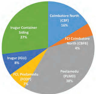
Coimbatore, being a major hub for textiles, industry, commerce, IT, healthcare, and manufacturing, witnesses high volumes of goods traffic. Key corridors like Palakkad Road, Avinashi Road, and areas around Ukkadam bus terminal face heavy congestion due to freight movement. With the Neelambur–Madukkarai bypass on NH-544 serving as the only major bypass, much of the external freight traffic is forced into city roads. Goods such as cotton, agricultural produce from nearby districts, and fabrics from Salem arrive via road, while steel is predominantly transported through rail, highlighting the need for improved freight corridors and bypass infrastructure to ease city congestion. Tonnage of around 1.98 million tonnes (unloading) is handled at railway stations with details presented in Table 7.3.
Table 7.3Annual Volume of Freight handled at key railway goods yards/sidings in Coimbatore LPA (unlo ading) – FY 2024-25
S. No
Railway Goods Yard/Siding
Commodity Handled
Annual Volume Handled (Million Tonnes)
1
Coimbatore North (CBF)
Rice, Paddy, Wheat, Fertilizer, Soda/Salt, Sugar
0.44
2
Food Corporation of India Grain Godown Siding Coimbatore North (CBFB)
Rice and Food grains
0.12
3
Peelamedu (PLMD)
Iron and Steel
1.03
4
Food Corporation of India Siding, Peelamedu (FCOP)
Rice and Food grains
0.18
5
Irugur (IGU)
Cement, Wheat and Maize
0.21
6
Irugur Container siding
Cement, others
0.74
Total
2.72
Source: Southern Railway
7.5 Traffic And Travel Characteristics
Figure 7.1: Split of Annual Freight Volume handled at railway goods sheds/sidings in Coimbatore LPA
There is no dedicated truck terminal in Coimbatorve LPA and currently trucks are parked at the existing truck lay by at Ukkadam. It has been observed that around 367 vehciles enter and exit the location in a day. The current facility accommodates a smaller number of trucks leading many drivers to seek private solutions elsewhere.
Freight movement is currently concentrated at locations like Malumichampatty, Pooluvampatti, Karumathampatti, Kovilpalayam, Narasimhanaickenpalayam, Madukkarai, Sulur, and Sangampalayam. Due to the absence of designated infrastructure, goods vehicles are often forced to park along roads, creating congestion, safety risks, and mobility issues in the urban core.
7.5.1Vehicles Registration Statistics
Vehicle registrations in Coimbatore have increased significantly over the years. Two-wheelers dominate at 80%, followed by cars at 16%. This surge is due to better economic status and lack of efficient publi c transport. Increased private vehicle use has led to traffic congestion on narrow roads. High density and rapid growth of vehicles have worsened the transport situation to a significant extent. Coimbatore city has a very high vehicle to population ratio.
Table 7.4Vehicle Registration Statistics
Vehicle Categories
2018
2019
2020
2021
2022
2023
2024
2 Wheeler
75,755
62,139
49,788
56,660
69,547
71,403
74,301
Car
18,158
16,179
12,423
16,301
20,234
21,678
20,261
Motor Cab
1,572
1,399
542
325
639
989
2,437
Three Wheeler (Passenger)
9
85
138
308
868
1,976
1,393
Three Wheeler (Goods)
1,955
1,578
540
172
230
329
693
Goods Carrier
3,207
3,384
2,209
2,744
3,352
3,676
3,051
Agricultural Tractor
189
188
188
248
295
206
208
Construction Equipment Vehicle
76
202
163
207
173
229
244
Bus
21
31
19
17
191
355
457
M-Cycle/Scooter
9,262
17,856
5,106
54,117
66,774
69,327
71,114
Others
683
501
383
87
78
140
263
Total
1,10,887
1,03,616
71,634
1,31,186
1,62,381
1,70,308
1,74,422
Sources: Vaahan Dashboard
7.5.2Trip Characteristics - Mode Share
The trip characteristics analysed is from primary surveys conducted as part of the CMP 2022. The detailed analysis examines trip distribution by mode, categorizing travel patterns into vehicular trips and walk trips. Key aspects such as travel behaviour, mode share, and trip length characteristics have been analysed to inform transportation planning and policy recommendations, as outlined below.
7.6 Diagnostics – Key Issues and Challenges
Table 7.5Modal Share
Category
Type of Vehicle
Percentage (%)
Public Transport(30.7)
Bus
21.0
Minibus
0.5
Train
0.3
School Bus
8.9
Intermediate Public Transport (IPT)
Taxi
0.4
Auto
4.2
Private Transport(42.2)
Car, Van, Jeep
5.2
Two Wheelers
37
Non-motorised Transport (NMT)
Cycle
1.8
Walk
20.8
Total Trips
100.00
Sources: Comprehensive Mobility Plan – 2022 (Coimbatore)
Identifying key issues is a key step in assessing the city’s existing transportation landscape. The key issues and challenges have been identified impacting urban mobility, such as congestion, inadequate public transport, high pollution levels, road safety concerns, and accessibility gaps.
7.6.1Roads and Intersections
Inadequate carriageway width - A significant percentage of road network (~70%) has less than 20m right of way and there is inconsistent carriage way width.
Road network capacity is inadequate indicating the need for judicious use of available road space.
The road infrastructure has not expanded in tandem with the increase in the number of vehicles in the city.
Unsafe Junctions and Midblock - Pedestrian and two wheelers are the most affected in road accidents
Congestion leading to Lower Journey Speed - The journey speed within the core city during peak hour is observed to be less than 20kmph and in the expanded area it is between 21 to 30kmph.
7.6.5Limited use of Rail for city commute
Major towns are situated around the city having high interaction with the city. This is likely to be increased in the coming years. There will be need to provide regional transport services to these adjacent towns.
7.7 Transportation Strategies And Proposals
As Coimbatore’s population is projected to reach 58.24 lakhs, in 2041, assessing future travel demand becomes essential for sustainable urban growth. The projected demand helps in forecasting how people will move around the city, allowing planners to design transportation systems that can handle future pressure. It supports the formulation of strategies to reduce traffic congestion, environmental pollution, and ensure equitable and efficient mobility for all.
Transport demand is a function of land use and the growth of demand in various years vary depending upon the interrelationship of various landuse and traffic intensity in future years. Evaluating Coimbatore LPA’s urban growth and typology over time, it is evident that city represents concentric zone model where core city has higher population density and it decreases gradually outward. The surrounding suburbs is experiencing growth.
It is envisaged that intensive development will be taken up along the major arterial corridors of the city. Higher Population growth has been envisaged in the eastern region of Coimbatore LPA. To facilitate future development, a pre-planned transport network and system is planned integrating land use.
In accordance with the National Urban Transport Policy (NUTP), it is envisioned to encourage greater use of public transport and non-motorised transport to ensure that the growth of the Coimbatore area occurs in a sustainable manner. It is targeted to increase public transport mode share from the present 30.7% to 40% by 2041.
While framing proposals priority has been given to public transport, augmenting the road network, safety and non-motorised transport facilities. For developing strategies and proposals for Coimbatore LPA focus has been given on creating an integrated, sustainable, and efficient transport network that meets current and future mobility needs. For achieving the modal split as presented above, development strategies have been identified that will prioritize integrated public transport systems, multi-modal transportation, road network development plan, nonmotorized transport infrastructure, traffic demand management measures, freight management plan and seamless connectivity across various modes.
7.6.2Public Transport & IPT
Buses are the primary mode for medium-distance trips (avg. 7.4 km), highlighting the need to improve frequency, route coverage, and supporting infrastructure.
The present supply of buses is about 26 buses per lakh population vis-a-vis requirement of 40 buses per lakh population highlighting the need to augment the supply of buses.
A notable portion of trips are for students (avg. 7.1 km), indicating the need for safer school transport, better drop-off zones, and optimized timing.
Low Taxi and Mini-Bus Usage - Indicates limited role of shared mobility and feeder services; potential exists for expanding ridesharing, flexible transit, and coverage in underserved areas.
Traffic composition on roads indicates very high share of two wheelers. The share of cars is also growing indicating inadequate public transport system.
7.6.3 Pedestrian Facilities
Walking Remains Fundamental and Low Cycle Usage-A high share of walking trips (20.8%) emphasizes the importance of walkability and calls for safer, more comfortable pedestrian infrastructure. Cycling’s low share suggests safety concerns and inadequate infrastructure;
Lack of footpath - The city roads lack footpaths on most roads reflecting the poor pedestrian infrastructure in the city
7.6.4 Parking
Unregulated Parking
Absence of off-street parking facilities results in haphazard on-street parking along the roads, leading to congestion on roads.
7.7.1Road Network Improvements
To enhance the transportation network and address existing capacity constraints, roads have been identified to be widened and new road link proposals have been formulated for Coimbatore drawing on CMP 2023. The proposals aim to mitigate congestion, improve traffic flow, provide for development of a strategic road network to support the growth of the LPA and accommodate projected vehicular movement up to the year 2041.
7.7.1.1 Road Widening
Coimbatore’s arterial road network is characterized by major radial roads —Avinashi Road, Trichy Road, Pollachi Road, Palakkad Road, Mettupalayam Road, and Sathy Road — many of which face severe congestion due to the overutilization of their limited right-of-way (ROW), ranging between 8 meters and 30 meters. The insufficiency of existing carriageways, compounded by inefficient junctions, further restricts the overall capacity of the road network.
To address these challenges, a phased road widening strategy has been proposed. The strategy incorporates two components:
Widening of key arterial roads (NHs/SHs) which approach or exceed capacity in 2041 (based on factored CMP model flows)
Widening of key interconnecting roads in the newly developing areas up to the proposed Ring Road and the LPA boundary to ensure the formation of a strategic road network in the peripheral areas.
The phasing of the widening proposals is done such that widening of major roads (NH/SH) and roads in core areas are taken up in the first phase, followed by roads in remaining areas.
The upgradation of L&T Bypass is also recommended to include service lanes throughout to allow separation of local and freight traffic and allow for safer entry and exit from the Bypass Road. The L&T Bypass from Neelambur to Madukkarai currently operates with a 2-lane carriageway and acts as a major trunk route for traffic bypassing the core areas of the city. Heavy congestion and road safety issues
are currently noted and it is proposed to upgrade the road to utilize the right of way more effectively. In the first phase, it is proposed to upgrade the road to a divided 4-lane carriageway and then to 6-lane with service lanes in the second phase.
Table 7.6Details of Road widening Proposal – Phase 1
Road ID
Category
Road Name
Existing Lane
Proposed Lanes
Length (km)
B1
NH
Sathy Road - Saravanampatti to Kurumbapalayam
2
6
5.4
B2
NH
Trichy Road - Ramanathapuram to
4
6
19.4
B3
SH
SH271 - Siruvani Road
2
4
9.7
B4
SH
SHU52 - Palakkad Road
4
6
4.5
B5
SH
SH162 - Trichy Road Jn to Podanur
2
4
5.5
B6
SH
SH164 - Thadagam Road - KNG Pudur to Ring Road
2
4
1.9
B7
SH
SH233 - SITRA-Kurumbapalayam Road
2
4
7.0
B8
MDR
MDR 982 - Kaundampalayam to Thadagam Road
2
4
2.6
B9
MDR
MDR 877 - Thudiyalur-Saravanampatti road
2
4
8.1
B10
MDR
MDR978 Thudiyalur-Chinna Thadagam Road
2
4
3.6
B11
MDR
MDR 678 Saravanampatti-Kalapatti
2
4
4.5
B12
MDR
MDR678-Kalapatti to Arasur
2
4
5.3
B13
MDR
MDR1139 - Kurumbapalayam-Karichipalayam Road
2
4
7.7
B14
Other
Vellampatti-Kallipalayam Road - Neelambur
2
4
6.5
B15
Other
SIHS Road - Trichy Road to Airport
2
2
3.9
B16
Other
Road Connecting Trichy Road and Co-Operative Colony and Rajiv Gandhi Nagar
2
2
0.6
B17
Other
Scheme Road Between Radhakrishnan Mills & Palamudir Nilayam
2
2
0.4
B18
Other
60' Road connecting Avinashi Road
2
2
0.8
B19
Other
Road Connecting Perur Main Road with thadagam road through arul garden road and kumarasamy lake bund
2
2
2.1
Table 7.7Details of Road widening Proposal – Phase 2
Road ID
Category
Road Name
Existing Lane
Proposed Lanes
Length (km)
B21
NH
Palakkad Road
4
6 + 2 Service Lanes on both sides
9.7
B22
SH
SH163- Kochi-Palladam Road
2
6
3.5
B23
SH
SH163- Kochi-Palladam Road
2
6
23.7
B24
MDR
MDR438 - Avinashi Road to Sulur
2
4
5.6
B25
MDR
MDR437 - Sulur-Sellakkarichal
2
4
10.3
B26
MDR
MDR985 - Pappampatti
2
4
6.7
B27
MDR
MDR522 - Chettipalayam-Vadasithur Road
2
4
5.3
B28
MDR
MDR417 - Sellakarichal to Ring Road
2
4
1.8
B29
ODR
Sulur Market Loop Road
2
4
0.7
B30
ODR
L&T Bypass to SH163 Connection
2
4
4.8
B30
ODR
L&T Bypass to SH163 Connection
2
4
0.7
B31
ODR
Pappampatti Pooraandampalayam Road
2
4
5.7
Map 7.3: Road Widening Proposals
7.7.1.2 New Road Proposals
Ring Road
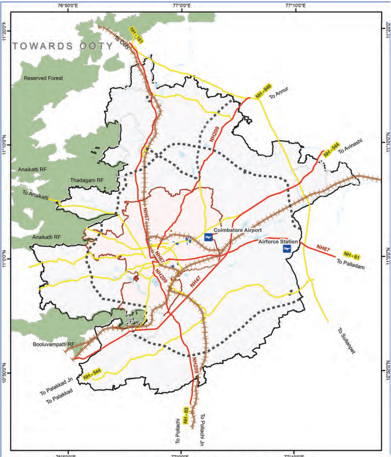
The Highways Department has proposed the development of a six-lane divided Outer Ring Road (ORR) around Coimbatore to enhance regional connectivity and alleviate traffic congestion in the core areas of the city. This will also provide connectivity between all radial roads, which is currently lacking.
The total length of the proposed ring road network is 119.3 Km, and this will encircle Coimbatore, ensuring seamless connectivity between major highways, industrial hubs, and residential zones. This infrastructure development is expected to significantly reduce travel time, enhance road safety, and facilitate economic growth by improving accessibility to commercial and industrial establishments.
Table 7.8Proposed Ring Road
S.N.
Proposed Ring Road
ROW (ft)
Length (Km)
A1
150 feet - Proposed (NH) Western Ring Road (Madukkarai to Gudalur)
150
32.36
A2
200 feet - Proposed (NH)Eastern Ring Road (Narasimanayakanpalayam to Karanampettai)
200
43.5
A3
200 feet - Proposed (NH) Southern Ring Road (Madukarai to Elakkarichel)
200
43.5
Sources: Comprehensive Mobility Plan – 2022 (Coimbatore)
This proposed ring road aims to decongest the city’s internal roads and improve overall mobility, and the alignment is illustrated in the Map 7.4.
New Link Roads
In addition to widening existing roads, the network improvement strategy includes the development of new road links to enhance connectivity between key corridors and address missing links within the urban fabric. A total of 4 new road proposals, spanning 30.4 km, have been identified to strengthen intra-city linkages and provide alternative
routes for traffic distribution. Additionally, a few minor links are proposed to be added as new alignments as part of widening of some roads.
A hierarchical classification of roads has been outlined to ensure the efficient performance of the road network. It is essential to develop continuous stretches in accordance with the recommended cross-sections.
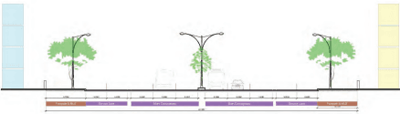
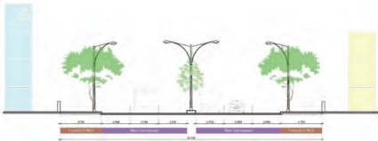
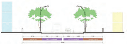
Four standard cross-sections have been proposed for corridors with right-of-way (ROW) widths of 18 meters, 24 meters, 30 meters and 45 meters. For urban roads, the focus is on mobility of people rather than vehicles and therefire, it is proposed that lane width of 3m (for 18 and 24m ROW, and for service lanes) and lane width of 3.25m (for 30m and 45m ROW) are adopted.
45m ROW:
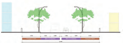
For corridors with a 45-meter ROW, the proposed cross-section includes a 1-meter-wide divider, a 6-lane divided carriageway for traffic movement (9.75 meters on each side), 6-metre wide service lane on both sides for local traffic with 0.5-metre service lane divider on both sides, and 5.75m for shared footpath and NMV lane with Multi-Utility Zone (MUZ) on both sides.
Figure 7.2: Proposed cross section for 45m ROW
30m ROW:
The proposed cross-section for corridors with a 30-meter ROW consists of a 1-meter-wide divider, a 6-lane divided carriageway for traffic movement (9.75 meters on each side), a 4.75-meter-wide shared footpath and NMV (Non-Motorized Vehicle) lane with MUZ on both sides.
Figure 7.3: Proposed cross section for 30m ROW
24m ROW:
For corridors with a 24-meter ROW, the proposed cross-section includes a 0.5-meter-wide divider, a 4-lane divided carriageway for traffic movement (6 meters on each side), a 5.75-meter-wide shared footpath and NMV (Non-Motorized Vehicle) lane with MUZ on both sides.
Figure 7.4: Proposed cross section for 24m ROW
18m ROW:
For corridors with an 18-meter ROW, the proposed cross-section includes a 0.5-meter-wide divider, a 4-lane divided carriageway for traffic movement (6 meters on each side), a 2.75-meter-wide footpath on both sides.
7.7.2Proposed Vehicular Grade-Separators and Rail-over Bridges
The increasing reliance on private vehicles, particularly cars and two-wheelers, has led to increased congestion on major roads in Coimbatore. Many key intersections experience excessive delays due to high traffic volumes, and at certain locations, conventional signalized junctions are ineffective in managing the traffic flow.
Additionally, railway level crossings act as major bottlenecks, causing delays and increasing accident risks. In general, the focus is on managing traffic flow at grade itself, but vehicular grade-separators are proposed at key intersections where traffic demand is projected to exceed the existing road capacity and significant congestion and delays are projected.
At-grade widening is not feasible due to right-of-way (ROW) constraints.
Safety issues are observed due to significant local traffic crossing high-speed through traffic, for example on the L&T Bypass.
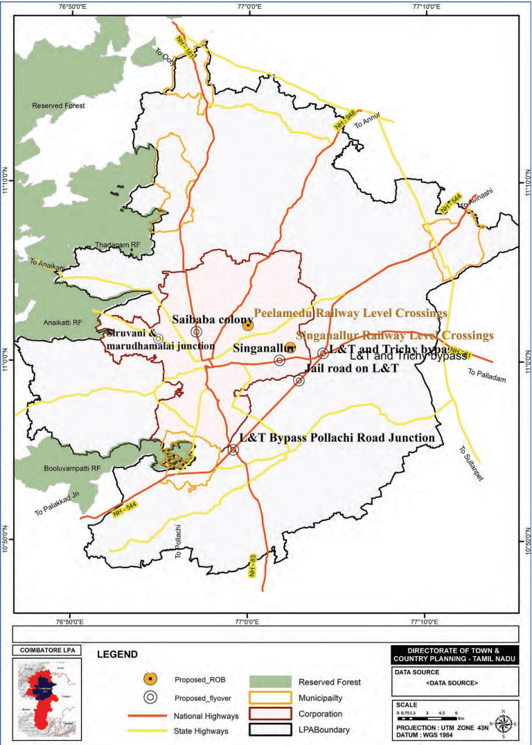
The complete list of proposed flyovers is provided in Table 7.12 and illustrated in the Map 7.5.
Table 7.12Proposed Vehicular Grade-Separator Locations and Phasing
The vehicular grade-separator on Mettupalayam Road at Sai Baba Kovil junction is currently in progress, and the remaining grade separators are proposed to be taken up in the first phase as they are located on roads that are proposed to be upgraded in the first phase.
7.7.2.1 Proposal for Rail Over Bridges (ROBs)
Railway level crossings contribute to significant traffic congestion and safety risks. To mitigate these challenges, two Rail Over Bridges (ROBs) have been proposed at critical level crossings under Phase 1 of the Comprehensive Mobility Plan (CMP) 2023. These ROBs are proposed at locations experiencing frequent delays due to rail traffic and are illustrated in the Map 7.5
Map 7.5: Proposed Vehicular Grade Separator and RoB Locations
Table 7.13Proposed RoBs and Phasing
SN
Location Names
Phase
1
Peelamedu Railway Level Crossings
Phase-1
2
Singanallur Railway Level Crossings
Phase-1
7.7.2.2 Junction Improvements
Efficient junction design is essential for ensuring seamless traffic flow, minimizing congestion, and enhancing road safety. A junction-specific approach, emphasizing traffic movement optimization, geometric design enhancements, and the integration of pedestrian and NMT (Non-Motorized Transport) infrastructure is proposed.
Based on traffic volume analysis, reconnaissance surveys, and stakeholder consultations, analysis is carried out, and improvements have been proposed for key junctions. The recommended geometric and infrastructure enhancements for the junctions will be subject to a detailed feasibility study to determine their implementation. In total 29 junctions have been identified for improvement. It is recommended that most of the locations lies on the same corridor, improvements shall be taken up at corridor level.
Table 7.14Proposed Junction Improvement Locations and Phasing
S. No
Location
Corridor Name
1
Lawley Road Junction
1
2
GCT Junction
1
3
Velandipalayam Junction
1
4
Edayarpalayam Junction
1
5
Mettupalayam Road - Home Science College
2
6
Crosscut Road Juction
2
7
Mettupalayam Road and Sanganur Road Side Road Junction
2
8
Thudiyalur Junction
2
9
Kongu Nadu College Junction
2
10
Periyanaickenpalayam Junction
2
11
Saravanampatti junction
3
12
Prozone Mall Junction
3
13
Athupalayam Junction
3
14
Saravanampatti - Kalapatti Pirivu Junction
3
15
Ganapathypudur
3
16
Oppanakara Street Junction
4
17
Town Hall Junction
4
18
Big Bazaar Road near CCMC
4
19
Lakshmi Mill Junction
4
20
Nava India Signal
4
21
KMCH Junction
4
22
7.7.2.3 Improvement of Accident-Prone Area
The following actions are likely to reduce the number of accidents occurring on Coimbatore’s roads:
Convert undivided road stretches to divided roads. Undivided roads are the most common infrastructure factor contributing to accidents. Undivided roads lead to overtaking resulting in head-on collisions that are severe. Where it is not possible, wide painted medians with longitudinal rumble strips can be provided as a short-term measure.
Improve pedestrian infrastructure, especially around bus stops and pedestrian walking areas to segregate pedestrians from vehicles. Pedestrian crossing facilities should also be improved through the use of clear road marking and signage, pedestrian activated signals and traffic calming measures to slow down speeding vehicles. Compliance with IRC 103 is required while designing road and pedestrian infrastructure.
Provide clear and visible road marking and signage. The design of every intersection should be clear, signals and stop signs should be warned of in advance, and directional signage and road markings should be easily visible even in heavy traffic. Clear markings and chevron signage before sharp curves would also help lower the number of accidents due to driver losing control on curved roads. Compliance with IRC 35 and IRC 67 is required for good quality and effective road markings and signage.
Enforce proper helmet use and improve compliance of MV Act Section 129. Encourage use of certified helmets meeting BIS standards.
Provide crash barriers to make rigid objects on roadside and median more crash-friendly and forgiving when impacted. Object impacts involving trees, kerbs, bridge walls, concrete poles, etc. result in serious injuries resulting in deaths. Hence, such objects need to be provided with road safety engineering devices such as reflective hazard markers (for conspicuity), guardrails and crash
cushions to help avoid the impact or reduce the severity of impact.
Implement a speed management program to control speeding. Match speeds to traffic conditions, provide adequate speed limit signage to warn drivers of changes, and enforce posted speed limits.
Enforce drink driving laws and educate people on the ill effects of alcohol abuse.
Implement regular vehicle inspections to deal with truck and passenger overloading, lack of reflectors, worn tires and other safety items (lights, wipers, steering, brakes, etc.).
Safety regulation to be coordinated with RTOs-Issuance of licences Currently, traffic rule violations and poor driving behaviour exacerbate road safety issues caused by the current infrastructure. Along with improvement of infrastructure through the provision of medians, road marking and signages, it is proposed that the process of obtaining a driving licence is made more stringent and transparent. This will ensure that licensed drivers are aware of traffic rules and are safe, qualified drivers. All driving test centres in the Coimbatore LPA are proposed to be upgraded to automated driving testing centres. This will eliminate human interference in the testing process and ensure that the driving testing is done in a robust, fair and transparent manner. A sensor-based automated driving testing centre for cars has been implemented in Karur. In Delhi, all driving testing centres for both cars and twowheelers have been automated and driving licenceseekers are tested on their driving skills through sensors and video analytics technology with no human intervention. It is similarly proposed to upgrade centres in Coimbatore. This may be done through partnerships with private agencies to carry out construction of test tracks, set up automation and IT systems, and provide maintenance support. Capacity building of RTO employees shall be conducted in parallel to support their management of the automated facility.
Per Capita office space (in sq.ft) for formal workers including shared spaces
Additional buffer on space on existing floor space (in %) for future readiness
Total office space required (in million sq.ft)
1
Business as usual (BAU)
3,54,696
130
10%
50.72
2
High growth trajectory (HGT)
5,81,886
83.21
3
Aspirational growth (AG)
11,25,027
160.88
(Note: Work space = Total Formal Workers × 130 sq. Ft × 1.10 (buffer), converted to million sq. Ft (MSF))
Total industry space required (in million sq.ft)
1
Business as usual (BAU)
5,91,160
250
10%
162.57
2
High growth trajectory (HGT)
8,83,001
242.83
3
Aspirational growth (AG)
15,67,002
430.93
(Note: Work space = Total Workers × 350 sq.ft × 1.10 (buffer), converted to million sq.ft (MSF))
6.5.4.4 Land Use Translation
To accommodate the net workspace gap for advanced secondary sector, land must be allocated and regulated within the following use zones:
6.5.4.5 Applicable Land Use Zones
Industrial Zones: These zones are primarily for manufacturing, assembly, and high-tech production activities. They are suitable for flatted factories and specialized manufacturing parks.
Special Economic Zones (SEZs): These zones offer relaxed regulations and higher FSI, promoting exportoriented and high-tech manufacturing, which aligns with the growth of advanced secondary sectors like electronics and clean-tech manufacturing.
6.5.4.6 Estimated Land Requirement (2041)
Table 6.11Estimated Land Requirement - 2041
S. No
Scenarios
Total industry space required (in million sq.ft)
FSI
Total land area required (in sq.ft)
Total land area required (in sq.km)
1
Business as usual (BAU)
162.57
1.5
10,83,79,294
10.07
2
High growth trajectory (HGT)
242.83
2.5
9,71,30,145
9.02
3
Aspirational growth (AG)
430.93
3.5
12,31,21,585
11.44
6.5.4.7 Flatted Factories
This typology allows vertical integration of clean, highvalue manufacturing in urban industrial zones, optimizing land use efficiency, encouraging clustering of innovation-oriented units, and enabling shared infrastructure. It also supports urban employment generation without compromising environmental performance or urban aesthetics.
Maintenance zones, common utilities, emergency access
Basement/Utility Water storage & recycling
Parking & mechanical
utilities
6.5.4.8 Facilitating Commercial Space Integration in Coimbatore LPA
As Coimbatore evolves into a regional engine of economic activity, commercial spaces are expected to serve as critical enablers for trade, retail, finance, and enterprise services. Beyond traditional commercial corridors, the next phase of growth must integrate flexible commercial typologies across mixed-use hubs, sub-centres, and transitconnected zones. The objective is to foster an inclusive and spatially distributed commercial economy that supports both formal retail and entrepreneurial activity.
In line with this, the Coimbatore Local Planning Area (LPA) must proactively assess the demand for commercial space and make necessary provisions across land use and development regulations to ensure balanced growth and economic inclusivity.
6.6 Methodology for Estimating Commercial Space Demand
6.6.1 Assumptions and Parameters
Reference Period: Last 5 years till 2024
Total Commercial Space Approved by DTCP: 67,04,983.86 sq.ft.
Population in 2025: 35,86,986
● Per Capita Commercial Space Usage: ~1.98 sq.ft. of BUA
Table 6.13Assumptions and Parameters for Commercial Space Demand
S. No
Scenarios
Total incremental population (2041)
Per Capita commercial space (in sq.ft)
Total commercial space required (in million sq.ft)
1
Business as usual (BAU)
26,27,377
1.9
5.20
2
High growth trajectory (HGT)
31,30,100
6.20
3
Aspirational growth (AG)
44,64,393
8.84
B20
Other
Sidhapudur Flyover Landing to Nava India junction
2
4
4.0
4
10.6
1
A6
Karamadai Western Bypass
4
1.8
2
A7
Realignment of MDR417 as part of widening
4
1.0
2
Total Length (Km)
30.4
These road widening and new road link proposals are expected to significantly enhance Coimbatore’s urban mobility by facilitating smoother traffic flow, reducing travel time, and supporting the city’s long-term transportation demands.
Additionally, in line with IRC SP:118-2018, it is recommended to plan for vehicular roads every 250m for a well-connected street network in greenfield areas. A vehicular grid of 250 m x 250 m of collector roads should form an efficient network system for residential and non-residential areas, with a grid of 1000 m x 1000 m comprising arterial roads should be added.
Scheme roads proposed by Coimbatore Corporation comprise minor link roads (new and widening) to provide better connectivity for residential neighbourhoods to the rest of the strategic road network. These are primarily shorter links of 0.1 to 2km long and are detailed below.
Table 7.10Details of Minor Link Road
SN
Name of road Missing links
Proposed no of lanes
Length (km)
Phase
A8
Road connecting Thirumagal Nagar & Meena Estate Road through Hindustan Hospital Road and Anjaneyar Temple Road
2
0.35
Phase I
A9
Road Connecting Dr.Nanjappa Road and Addis Street
2
0.06
Phase I
A10
Road Connecting Fun Mall Road Thru PSG Site With 40' PPS Colony Road Extending To 50' Anna Nagar Extension Road Behind Varadharaja Mills, Peelamedu
2
0.12
Phase I
A11
Road to Connect Brookfield Road with MTP Road Through Devanga Higher Secondary School and Shanmugam Road near Senthil Hospital
2
0.06
Phase I
A12
A Bridge to Connect Fun Mall Road With Hudco Colony 40' Road Behind Ranga Vilas Mills, Peelamedu
2
0.04
Phase I
A13
Road Connecting SNR College Road with Avarampalayam Road through Nava India Road & Srivari Apartments Road
2
0.11
Phase I
A14
Road connecting Avinashi Road opp to Fun Mall with Thanner Pandal Road through Ellai Thottam Road Linking PF Colony Road
2
0.75
Phase I
A15
100' Scheme Road Connecting Nanjundapuram Road and Sungam By-pass Road through Sivaram Nagar
2
0.18
Phase I
A16
Road connecting Avinashi Road and 50' Anna Nagar Extn Road through Varadharaja Mills
2
0.50
Phase I
Total Length (km)
2.20
Table 7.11Details of DDP Roads
Road ID (DDP)
Road Name
Width ft
DDP Name
Length (KM)
BB
Saramedu to nanjundapuram
60
SinganallurDDP50
0.69
BB
Valankulam to nanjundapuram
80
SinganallurDDP51
1.52
B1B1
Valankulam to nanjundapuram
80
SinganallurDDP51
0.27
BB
Emami aerocity to sarkar samakulam
60
KalapattyDD3
0.52
CC
Emami aerocity to vellanaipatti
40
KalapattyDD4
0.81
C2C2
Vish villas to m s garden
40
KalapattyDD4
0.88
BB
Saramedu to nanjundapuram
60
Singanallur49
1.1
AA
Saramedu to nanjundapuram
80
Singanallur49
0.68
AA
Saramedu to nanjundapuram
80
SingnallurDD48
0.92
BB
Barani hydraulics india privat to
30
Kalapatty5
0.42
A2A2
Kalapatty main road to vellanaipatti
80
Kalapatty9
0.92
AA
Unicraft cnc to lemon tree hotel
80
Kalapatty10
0.31
B1B1
A-a 80 ft road to b-b 60 ft road connected road
60
Kalapatty10
1.03
B2B2
B1-b1 60 ft road to villakurichi
60
kalapatty10
0.6
AA
Unicraft cnc to kalapatty main road
80
Kalapatti11
0.69
CC
Kalapatty main road to nehru st
40
Kalapatty12
0.44
BB
Nehru st main road nehru cut road
60
Kalapaty12
0.67
B1B1
Kaikolapalayam main road nehru st
60
Kalapaty12
0.65
B1B1
Kalapatti main rd to nehru nagar west cut rd
60
Kalapaty16
0.62
B1B1
Fathima nagar
60
SaravanampattyDDP1
0.3
B3B3
Tank st to athiyapalayam
60
SaravanampattyDDP1
0.67
BB
Keeranatham road to relax inn road
60
SaravanampattyDDP2
0.64
B1B1
Relax inn road to beside premier die cast0
60
SaravanampattyDDP2
0.58
B4B4
Saravanampatti - thudiyalur main road to keeranatham road
60
SaravanampattyDDP2
0.28
CC
Sahara city road to vkv kumaraguru nagar road
60
SaravanampattyDDP3
0.98
BB
Ramanandha nagar sathy road near to karthikeya nri park
100
SaravanampattyDDP5
1.44
A1A1
Sai nagar to kanuvai road prasenna mahaganapthy road
80
Thudiyalur4
0.9
AA
Sai nagar to kanuvai road prasenna mahaganapthy road
80
Thudiyalur4
0.74
BB
East(day to day )-siva nagar) to west(sundakkamuthur school, dharshini garden)
80
Sundakamuthur5
0.81
AA
Panaimarathur) to chokkampudhur
80
Kumarapalayam2
0.72
BB
Chokkampudur road)
60
KumarapalayamDDP2
0.38
B1B1
B3,b1,b2 scheme road jucn to dd 1 b-b road continue
60
KumarapalayamDDP2
0.31
C2C2
B-b rroad to dd 2 c-c road continue
40
KumarapalayamDDP3
0.15
C3C3
Western side of arul garden c6-c6 to c4-c4 (arul garden) link road
40
KumarapalayamDDP5
0.44
BB
Sri sowdeswari vidyalaya road
40
KumarapalayamDDP5
0.35
C4C4
C-c to a-a(rower line road) link road
40
KumarapalayamDDP5
0.26
CC
Arul garden near sowdeswari school) to north side of amul nagar
40
KumarapalayamDDP5
0.41
A1A1
Bharathi road to chokampudur road
80
KumarapalayamDDP6
0.49
CC
Perur main road to c1-c1 road
60
KumarapalayamDDP7
0.57
C1C1
Telungupalayam to c-c road
60
KumarapalayamDDP7
0.61
B3B3
Sri kovial tirupati temple road to adithya avenue
60
Kavudampalaym3
0.71
BB
Lakshmi nagar file foundation to lakshimi nagar
60
Kavudampalaym4
0.14
C1C1
Rrr nagar first street to dr. Ambedkar road
50
Telungupalayam6
0.84
C1C1
Rrr nagar first street to dr. Ambedkar road
50
Telungupalayam6
0.04
C2C2
Rrr nagar first street to dr. Ambedkar road
50
Telungupalayam6
0.68
CC
Rrr nagar first street to lal bagadhur sastri road
50
Telungupalayam6
0.67
B1B1
Stp road to ramanis coconut grove apartment to vellore road
50
SinganallurDDP42
0.84
AA
Singanallur kulam
80
SinganallurDDP37
0.85
B3B3
Trichy road to Vellore Road
50
SinganallurDDP37
0.37
A1A1
Thudiyalur - Saravanampatti Main road
80
SaravanampattyDDP2
1.09
A1A1
Thudiyalur - Saravanampatti Main road
80
SaravanampattyDDP2
1.09
B1B1
PMR nagar road to PMR nagar road
60
Kavudampalaym3
0.71
B1B1
Sri sowdeswari vidyalaya road
40
KumarapalayamDDP5
0.35
Total Length
Total Length
Total Length
34.2 Km
34.2 Km
Map 7.4: New Link Road Proposals
Figure 7.5: Proposed cross section for 18m ROW
Chinniyamapalyam Junction
4
23
Pioneer Mill road and Avinashi Road
4
24
Anna Statue Junction
4
25
Chitra Circle
4
26
Sungam Junction
5
27
Ramanathapuram Junction
5
28
Ondipudur flyover junction
5
29
Sundarapuram Junction
6
Key recommendations to be considered for improvement of the junctions are:
Geometric Design Optimization - Realignment of roundabouts, channelizers, and intersection radii; provision of lane markings, signage, and street lighting.
Pedestrian & NMT Infrastructure - Continuous footpaths, zebra crossings, pelican signals with beepers, and gradeseparated crossings (FOBs, subways, skywalks).
Dedicated NMT Lanes - Provision of separate lanes for bicycles and other non-motorized transport based on land availability.
Bus Bays & IPT Facilities - Relocation of bus stops and auto bays 150m away from junctions; designated waiting areas.
Signalization & Traffic Control - Installation of traffic signals at uncontrolled junctions; conversion of highvolume roundabouts into signalized intersections; provision of U-turn facilities and channelizers.
Encroachment Management - Dedicated spaces for hawkers/kiosks away from intersections; strict enforcement against illegal footpath and roadway encroachments.
Surveillance & Safety Measures - Installation of highvisibility lighting and CCTV cameras at high-risk junctions.
Map 7.6: Proposed Junction Improvements
Integration of road design – laning of roads, reduce lane width, junction turn – clear marking, merging of lanes, designated lanes for two wheelers, IPT, Buses, cars. The above recommended measures should be taken up on priority for all the radial roads connecting Coimbatore with other major cities/towns.