10.9.5 Block Costing for Proposed substation - Coimbatore LPA.... 506
xi
List of Abbreviations
AC
Air Conditioned
AG
Aspirational Growth
AHP
Affordable Housing in Partnership
AID
Automatic Incident Detection
API
Application Programming Interface
ATIS
Automatic terminal information service
ATMP
(Assembly, Testing, Marking & Packaging
ATMS
Advanced traffic management system
BAU
Business as Usual
BFSI
Banking, Financial Services, and Insurance
BIS
Bureau of Indian Standards
BOV
Battery Operated Vehicles
BPO
Business process outsourcing
BWSSB
Bangalore Water Supply and Sewerage Board
CAGR
Compounded Annual Growth Rate
CASC
Coimbatore Auto Sports Club (
CBD
Central Business District
CBIC
Chennai-Bengaluru Industrial Corridor
CBIC
Chennai-Bengaluru Industrial Corridor
CBMIC
Chennai Bengaluru-Mumbai Industrial Corridor
CBSE
Central Board of Secondary Education
CCMC
Coimbatore City Municipal Corporation
CCTV
Closed-circuit television
CETPs
Common effluent treatment plants
CHC
Community Health Center
CHIL SEZ
Coimbatore Hi-tech Infrastructure Private Limited Special Economic Zone
CIBI
Coimbatore Innovation and Business Incubator
CII
Confederation of Indian Industry
CIT
Coimbatore Institute of Technology
CKIC
Chennai - Kanniyakumari Industrial Corridor
CLPA
Composite Local Planning Area
CMP
Comprehensive Mobility Plan
CNG
Compressed Natural Gas
CODISSIA
Coimbatore District Small Industries Association
xxvi
CPCB Central Pollution Control Board CPHEEO Central Public Health and Environmental Engineering Organisation CPS Community Parks CUMTA Chennai Unified Metropolitan Transport Authority CWSN Children With Special Needs CWSS Combined Water Supply Schemes DAY-NULM Deen Dayal Antyodaya Yojana - National Urban Livelihoods Mission DEWATS Decentralised Wastewater Treatment System DGPS Differential Global Positioning System DHH District Headquarter Hospital DMA District Metering Areas DPSUs Defence Public Sector Undertakings DRDO Defence Research and Development Organisation DSDC District Skill Development Centre DTCP Directorate of Town & Country Planning ECBC Energy Conservation Building Code ELCOT Electronics Corporation of Tamil Nadu ESDM Electronics Hardware Manufacturing ESDM Electronics System Development and Maintenance ESI Employees State Insurance ESR Elevated Storage Reservoirs ESZ Eco-Sensitive Zones ETA Estimated Time of Arrival ETC Estimated Time of Completion ETP Effluent Treatment Plant EWS Economically Weaker Section FAR Floor Area Ratio FHTC Functional Household Tap Connections FMSCI Federation of Motor Sports Clubs of India FRL Full Reservoir Level FSI Floor Space Index FSTP Faecal Sludge Treatment Plant GCCs Global Capability Centres GCP Ground control point GDDP Gross District Domestic Product GDP Gross Domestic Product GER Grass Enrollment Ratio GI Geographic Indication
xxvii
GIS Geographical Information System GoTN Government of Tamil Nadu GQ Golden Quadrilateral GSDP Gross State Domestic Product GSI Geological Survey of India GSR Ground Service Reservoirs GVA Gross Value Addition H&UD Housing & Urban Development HACA Hill Area Conservation Authority HDI Human Development Index HGT High Growth Trajectory HIG Higher Income Group HSC Health Sub-Center HVAC Heating, ventilation, and air conditioning ICCC Integrated Command and Control Centre ICD Inland container depots ICTT International Container Transshipment Terminal IIS Indian Institute of Science IISER Indian Institute of Science Education and Research IIT Indian Institute of Technology ILPs Integrated Logistics Parks IMD Indian Meteorological Department IPHS Indian Public Health Standards IPT Intermediate Public Transit IRC Indian Road Congress ISRO Indian Space Research Organization IT Information Technology ITeS Information Technology Enabled Services ITI Indian Training Institute ITS Intelligent Transport System JJM Jal Jeevan Mission JNNURM Jawaharlal Nehru National Urban Renewal Mission KLD Kiloliters per Day L&T Larsen & Toubro Limited LIG Lower Income Group LPA Local Planning Area LPCD Liters per capita per day LPO Legal Process Outsourcing
xxviii
MBBR Moving Bed Biofilm Reactor MICE Meetings, Incentives, Conferences, and Exhibitions MIG Middle Income Group MLD Million Litres per Day MMDA Madras Metropolitan Development Authority MMLP Multimodal Logistics Park MPI Multidimensional Poverty Index MRTS Mass Rapid Transit System MSL Mean Sea Level MSME Micro, Small and Medium Enterprises MVA Megavolt-Amperes NBFCs Non-Banking Financial Companies NCT National Capital Teritory NDMA National Disaster Management Authority NDMC New Delhi Municipal Council NH National Highway NID National Institute of Design NIFT National Institute of Fashion Technology NIRF National Institutional Ranking Framework NMT Non- Motorized Transport NMV Non -Motorized Vehicles NPV Net Present Value NRSC National Remote Sensing Center NRW Non-Revenue Water NSSO National Sample Survey Office NULM National Urban Livelihood Mission OEMs Original Equiment Manufacturers OHT Over Head Tanks ORS Open Route Service OSM Open Street Map OSR Open Space Reservation PDS Public distribution system PHC Primary Health Center PHPDT Peak Hour Peak Direction Traffic PMAY Pradhan Mantri Awas Yojana PPP Public-Private Partnership PSU Public Sector Unit PSU Public Sector Unit
xxix
PwD Person with Disabilities R&D Research & Development RAY Rajiv Awas Yojana RFID Radio Frequency Identification RoB Rail over Bridge RoW Right of Way RRTS Regional Rapid Transit System RTO Regional Transport Office SaaS Software-as-a-Service SACON Sálim Ali Centre for Ornithology and Natural History SAFE Site Adjacent Factory Employee SBR Sequential Batch Reactor SCADA Supervisory control and data acquisition SDGs Sustainable Development Goals SEZ Special Economic Zone SH State Highway SHG Self-Help Groups SIDCO Small Industries Development Corporation SIPCOT State Industries Promotion Corporation of Tamil Nadu SME Small and Medium Enterprises SRTM Shuttle Radar Topography Mission STEM Science, Technology, Engineering, and Math STP Sewage Treatment Plant STPI Software Technology Park of India STR student-Teacher Ratio SUH Shelter for Urban Homeless T&CP Town & Country Planning TANGEDCO Tamil Nadu Generation and Distribution Corporation Limited TANTRANSCO Tamil Nadu Transmission Corporation Limited TDM Traffic Demand Management TIDCO Tamil Nadu Industrial Development Corporation TIDEL Tamil Nadu Industrial Development Corporation and Electronics Corporation of Tamil Nadu TIFR Tata Institute of Fundamental Research TMC Traffic Management Centers TNAU Tamil Nadu Agricultural University TNCDBR Tamil Nadu Combined Development Building Rules TNDIC Tamil Nadu Defence Industrial Corridor TNEB Tamil Nadu Electricity Board
TNGECL Tamil Nadu Green Energy Corporation Limited TNHB Tamil Nadu housing board TNPCB Tamil Nadu Pollution Control Board TNPDCL Tamil Nadu Power Distribution Corporation Limited TNPGCL Tamil Nadu Power Generation Corporation Limited TNSRLM Tamil Nadu State Rural Livelihood Mission TNSSGF Tamil Nadu Startup Seed Grant Fund TNSTC Tamil Nadu State Transport Corporation TNUHDB Tamil Nadu Urban Habitat Development Board TNULM Tamil Nadu Urban Livelihood Mission TOD Transit Oriented Development TP Town Panchayats TWAD Tamil Nadu Water Supply and Drainage Board UASB Upflow Anaerobic Sludge Blanket UDA Urban Development Authority UGPHC Up Graded Primary Health Centre UGSS Under Ground Sewerage Schemes ULB Urban Local Bodies UMTA Unified Metropolitan Transport Authority UNESCO United Nations Educational, Scientific and Cultural Organization UPHC Upper Primary Health Center URDPFI Urban and Regional Development Plans Formulation & Implementation URPs University Research Parks USGS United States Geological Survey WTP Water Treatment Plant
1.1 Background
A master plan is a comprehensive and strategic document that guides future growth and development by integrating built environments, economic conditions, social settings, and surrounding landscapes to ensure organized and sustainable urban expansion. Serving as a decisionmaking blueprint, it outlines a clear vision, goals, and a structured development approach. This plan is widely applied to address key aspects such as land use, transportation, infrastructure, and environmental sustainability to promote balanced and integrated growth. By establishing long-term objectives and implementation strategies, master plans enable the execution of essential policies, projects, and initiatives while remaining adaptable to evolving needs.
1.2Purpose of the Master Plans
The Tamil Nadu Town and Country Planning Act, 1971 provides a comprehensive framework for the systematic development and utilization of both rural and urban land across the state. This legislative framework facilitates the preparation and implementation of Master Plans to ensure planned growth and sustainable development.
The Master Plan encompasses various aspects of land use planning, infrastructure development, environmental conservation, and socio-economic advancement. The master plan may provide any or all of the following requirements:
• To determine how land in the planning area is used.
To allocate or reserve land for residential, commercial, industrial, and agricultural purposes, as well as for parks, playgrounds, and open spaces.
• To allocate or reserve land for public buildings, institutions, and civic amenities.
To make provisions for national highways, arterial roads, ring roads, major streets, railways, airports, canals, and other transportation links.
To outline traffic and transportation patterns, including road improvements and circulation systems.
To reserve for future development, expansion, and new housing projects.
To address improvements for poorly designed areas, outdated developments, slums, and population relocation wherever necessary.
Further to the above, the implementation of various other acts and regulations requires the master plan to provide for the following:
To ensure the provision of essential amenities, services, and utilities.
To make detailed development plans for specific zones, including housing, shopping centres, industries, civic facilities, and educational and cultural institutions.
• To regulate architectural features, building heights, number of floors, setbacks, open spaces, and land use.
To define the stages for implementing the Master Plan, and any other necessary matters, as required to be included.
To incorporate provisions for disaster management, including flood mitigation, cyclone-resistant infrastructure, earthquake-prone zone regulations, and emergency evacuation routes.
To allocate and protect water resources, including rivers, lakes, groundwater recharge zones, and watershed areas, ensuring sustainable usage and prevent pollution.
To include provisions for critical social infrastructure such as hospitals, community centres, and welfare institutions to cater to the needs of the population.
To address the development and maintenance of physical infrastructure, including water supply and sewage systems, stormwater drainage, solid waste management, and power supply networks.
The Urban and Regional Development Plans Formulation & Implementation (URDPFI) 2015 guidelines, formulated by the Town & Country Planning Organisation, Government of India provides guidelines for preparation of Master Plan inter-alia indicate:
The Master Plan (Development Plan) shall aim to provide detailed strategies and physical proposals to implement policies from the Perspective Plan and Regional Plan, based on economic and social needs, public aspirations, available resources, and priorities.
• To ensure affordable housing provisions and slum rehabilitation, as equitable access to shelter ensures inclusive urban growth.
1.3 Need for Master Plan
The Master Plan also identifies areas that need preservation, conservation, and development, particularly those with ecological value, natural scenery, and significant landscapes.
• It includes the protection of historical, architectural, and scientifically important structures, as well as environmentally sensitive areas.
The Master Plan will be prepared using Geographic Information System (GIS)-based mapping and spatial analysis to ensure accurate land-use planning, infrastructure management, and data-driven decision-making. The typical timeframe for these plans is 20-30 years, with phased planning in 5-year intervals for periodic reviews.
Coimbatore, known as the “Manchester of South India,” has a strong industrial legacy, particularly in textiles, and has evolved into a major hub for manufacturing, IT, and education. The city is also enriched with natural resources, including the Western Ghats, protected forests, and interconnected lakes, which are vital to its ecosystem. However, with rapid urbanization, industrial growth, and ecological sensitivity, a vision for stretgic development is essential
The existing Coimbatore Master Plan, approved in 1994, was formulated with a proposed land use plan for 2011. Since its horizon period is attained and the LPA encompassing the various Urban Local bodies such as Coimbatore Corporation and other municipalities, has undergone significant urban expansion, there is a need to update the master plan. The revised plan must regulate and facilitate growth while ensuring environmental sustainability and public welfare. Additionally, the planning area was expanded from 1,286.80 sq. km to 1,531.57 sq. km as per the G.O. (Ms) No. 188, H&UD Department, dated 25.10.2022, addressing the increasing developmental demands.
With the upcoming establishment of an Urban Development Authority (UDA) for Coimbatore, a comprehensive master plan will be crucial in guiding future development, implementing strategic policies, and fostering a balanced urban ecosystem. The new master plan aims to promote sustainable growth, inclusive development, and an enhanced quality of life for its residents while integrating ecological conservation and modern infrastructure.
1.4 Master Plan for Coimbatore LPA
The Coimbatore Local Planning Area i.e. the city and its influence area considered for planning purpose was first delineated in 1974 comprising the Coimbatore Municipality and 45 Revenue villages of Palladam Taluk of area 593.45 sq.km. However, by a subsequent notification in 1980 the Coimbatore planning area or the Local planning area was revised to cover a larger area comprising the Coimbatore Corporation, Madukkarai Township, 31 Town Panchayats and 55 Revenue villages and was notified by G.O.(Ms.) No.503 H&UD Dept. dated 17.04.1980. The expanded area was 1287 sq.km. Separately, Kurichi, located adjacent to Coimbatore Local Planning Area was identified for development as a New Town and the area comprising Kurichi, Malumichampatti and Seerapalayam of 47.97sq.km was declared as Kurichi New Town planning area in G.O.(Ms.) No.494 H&UD Dept. dated 19.06.1983. More than a decade later the first Master Plan for Coimbatore as well as the Kurichi New Town Development plan were prepared and approved in 1994 and 1995 respectively. DTCP has prepared and approved 60 Detailed Development Plans during the period from 1974 to 2012 for different areas within the LPA. Historically, 11 Town Planning Schemes were prepared and approved from 1933 to 1972.
The Second Master Plan was initiated with an expanded jurisdiction, incorporating additional villages in Coimbatore District under Section 10(1) of the Act, as per G.O. (Ms) No. 41, H&UD Department, dated 26.02.2014. This extended the planning area to include 1 Corporation, 4 Municipalities, 21 Town Panchayats, and 66 revenue villages. The Coimbatore Local Planning Area (LPA) was officially declared under Section 10(4) of the T&CP Act, 1971, through G.O. (Ms) No. 188, H&UD Department, dated 25.10.2022, expanding its jurisdiction to 1,531.57 sq. km, covering eight taluks of Coimbatore District viz., Coimbatore North, Coimbatore South, Annur, Sulur, Kinathukadavu, Madukkarai, Perur, and Mettupalayam. Summary of the administrative boundary of Coimbatore LPA is detailed in Table 1.1.
1.7 Master Plan Preparation of 2021 – 2041
1.5 Urban Development Authority (UDA)
1.6 Hill Area Conservation Authority (HACA)
Table 1.1Administrative Summary of Coimbatore Local Planning Area
S. Administrative
No. of.
Area
No Category
Local Bodies
(in Sq. Km)
1. Corporation
1
257.81
2. Municipalities
4
97.56
3. Town panchayats
21
314.93
4. Revenue Villages
66
861.27
Overall LPA
92
1,531.57
The Coimbatore Urban Development Authority (UDA) was established with the jurisdiction of the same LPA boundary as per G.O. (Ms) No. 197, H&UD Department, dated 11.11.2022. This enables the seamless integration of planning and development functions. The UDA is expected to utilize the Master Plan as its primary tool for guiding sustainable urban growth, optimizing land utilization, and implementing strategic infrastructure development while addressing critical aspects such as transportation networks, environmental sustainability, and equitable distribution of civic amenities across the entire UDA area.
The Tamil Nadu Government established the Hill Area Conservation Authority (HACA) to protect ecologically sensitive hill areas and promote sustainable development. As per GO MS.No.44 (02.04.1990), unchecked activities like farming, tourism, and infrastructure in the Western Ghats have caused severe environmental concerns. While these developments benefit society, they strain fragile hill ecosystems. The Government recognized that hill areas need special policies, different from the plains, to prevent irreversible damage. HACA regulates development to ensure balance growth and conservation.
Since 17 villages in the Coimbatore LPA (Local Planning Area) fall under HACA, their ecological sensitivity is considered during the Master Plan preparation process to ensure sustainable development.
The Directorate of Town & Country Planning (DTCP), Government of Tamil Nadu, has undertaken the preparation of the Master Plan for Coimbatore Local Planning Area
(LPA) as part of its state wide urban planning initiative. The Directorate, Coimbatore Region, has directly overseen all technical studies, surveys, and stakeholder consultations in accordance with the Tamil Nadu Town and Country Planning Act, 1971, and relevant urban development guidelines. The planning process includes comprehensive land-use assessments, infrastructure evaluations, transportation studies, and environmental considerations, supported by GIS-based spatial analysis and ground verification. Stakeholder discussions and inter-departmental coordination ensure inclusive and sustainable planning. DTCP plays a crucial role in Coimbatore’s urban development by consolidating data, preparing draft proposals, and contributing to the finalization of the Master Plan that guides the city’s structured growth.
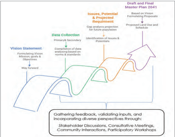
Figure 1.1: Methodology
1.7.2Vision
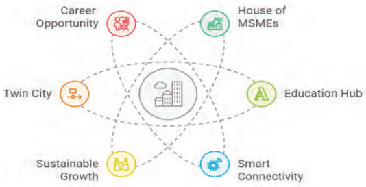
“To establish Coimbatore as a dynamic, interconnected regional hub that fosters technological innovation, industrial excellence, and seamless transportation, significantly enhancing the quality of life for all its residents.”
Coimbatore would evolve as a balanced, futureready city that is economically strong, socially inclusive, environmentally conscious, and well-connected. Coimbatore will become an even better place to live, work, and grow, offering opportunities for all.
Figure 1.3: Visioning Exercise
Core Principles:
The core principles that would guide achieving this vision include the following.
Interconnectedness: Emphasizing Coimbatore’s role as a central point of connection for technology, industry, and transportation.
Sustainability: Prioritizing environmental protection and sustainable development.
Innovation: Fostering a culture of technological advancement and economic growth.
Inclusivity: Ensuring that all citizens benefit from the city’s development.
Key Pillars of the Vision
Economic Growth & Industrial Excellence
Promote and expand MSMEs as a core engine of local economic activity
Support innovation and entrepreneurship through dedicated zones and incubators
Educational Leadership
Strengthen Coimbatore’s position as a hub for quality education
Attract and retain talent by fostering partnerships between industry and academia
Livelihood & Inclusive Opportunities
Generate diverse employment opportunities
Ensure equitable access to resources and benefits for all citizens
• Connectivity & Regional Integration
Improve transport infrastructure and public transit systems
Enhance connectivity with neighboring hubs such as Tiruppur, Erode, and the surrounding areas
Strengthen Coimbatore’s role as a central node in the regional economy
Environmental Sustainability
Prioritize green spaces, clean air, and sustainable urban practices
Protect natural resources while managing urban expansion responsibly
1.7.3Data Collection for Coimbatore Master Plan 2041
Preparation of this GIS-based master plan involved extensive secondary data collection from multiple reliable sources to ensure accuracy and comprehensiveness. Key datasets were gathered from various government departments, including spatial and land use records from the TNUHDB, TNHB, and TANGEDCO; infrastructure details from TWAD, Highways, TNEB, and environmental data from the TNPCB, and Forest Department. Additionally, critical inputs were obtained from stakeholder consultations with industry associations like CODISSIA, academic institutions, and urban development agencies. This robust data collection framework provided a strong foundation for spatial analysis, scenario modeling, and evidence-based policy formulation, ensuring the plan’s effectiveness in addressing Coimbatore’s future urban development needs.
1.7.1Existing Land Use Preparation
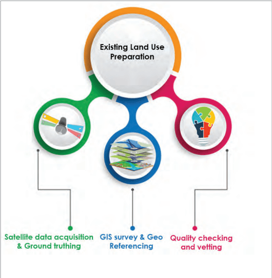
The Existing Land Use Map was prepared by DTCP using high-resolution satellite imagery from National Remote Sensing Center (NRSC). Cadastral frameworks were developed using village maps with survey numbers from the Survey and Land Records department. DGPS surveys collected GCPs for georeferencing scanned paper maps, and survey boundaries were digitized as GIS polygons with village names and survey numbers. The process included the following:
Satellite data acquisition & Ground truthing – The land use mapping process utilized satellite imagery sourced from NRSC, ISRO.
GIS Survey & Geo-Referencing – Cadastral maps were prepared using village survey records, with DGPS surveys collecting GCPs for georeferencing. Boundaries were digitized as GIS polygons, including village names and survey numbers. Ward maps for Coimbatore LPA were geo-referenced with town survey numbers captured in the database.
Quality Check & Base Map Preparation – The existing land use classification was quality-checked by overlaying TNEB electricity connection details on the GIS map. This cross-verification process confirmed occupancy patterns and validated actual land use against recorded data before finalization.
Figure 1.2: Existing Land Use Preparation
1.7.4Identification of Gaps and Demands
Gap and demand identification is a crucial step in master plan preparation, ensuring urban development aligns with both current needs and future growth. This process involves a comprehensive assessment of existing infrastructure, land use patterns, economic activities, environmental conditions, and social amenities to pinpoint deficiencies in service delivery and urban functionality. Key focus areas include housing shortages, transportation inefficiencies, lack of public spaces, industrial expansion requirements, and gaps in healthcare and education infrastructure. By analysing these factors alongside projected population growth, economic trends, and policy goals, the need for necessary interventions—from infrastructure upgrades to new development initiatives have been evolved.
The analytical phase was anchored in key statelevel and national policy frameworks to ensure alignment with Nation’s and Tamil Nadu’s long-term developmental objectives. Foremost among these were the Vision for a 1 Trillion Dollar Economy, the Tamil Nadu State Tourism Policy, the Tamil Nadu Housing and Habitat Development Policy, National framework for safe use of treated water 2022, Solid waste management rules 2016 and the Green Tamil Nadu Mission. These state-specific directives provided a strategic foundation and direction, guiding the Master Plan toward regionally grounded and forward-looking outcomes. In addition to State policies, the analytical phase also employed a projection based methodology based on established national frameworks and standards. Key reference guidelines included the Urban and Regional Development Plans Formulation and Implementation (URDPFI), directives from the National Institution for Transforming India (NITI Aayog), Indian Public Health Standards (IPHS), and recommendations from the National Disaster Management Authority (NDMA). In addition, demographic and infrastructure growth estimates were derived using the Compound Annual Growth Rate (CAGR) and benchmarks provided by the Central Public Health and Environmental Engineering Organization (CPHEEO). This approach enabled comprehensive scenario modeling and supported the formulation of evidence-based recommendations.
For the Coimbatore Master Plan 2041, this assessment plays a pivotal role in shaping land-use allocations, zoning regulations, and investment priorities. The findings ensure that the plan enhances urban efficiency, sustainability, and resilience while addressing critical gaps. Stakeholder consultations—including industry bodies, civic groups, and urban experts—further refine strategies, fostering balanced and inclusive growth. Through this data-driven approach, the master plan not only bridges existing service gaps but also anticipates future challenges, positioning Coimbatore as a well-planned, livable, and economically vibrant city.
1.7.6Planning Proposals
The master plan’s proposals aim to address existing gaps and support sustainable urban growth. First, it studies current issues—like land use, infrastructure, transport, and environment—to find what’s lacking. Then, it suggests solutions: better zoning, more housing and commercial spaces, improved transport, and smart city projects, including eco-friendly initiatives on renewable energy and waste management.
For Coimbatore Master Plan 2041, the focus is on making the city a strong manufacturing and IT hub, upgrading transport, and improving public facilities—all while protecting the environment. These proposals ensure balanced growth, making Coimbatore a resilient, inclusive, and economically strong city for the future.
1.7.5Stakeholder Engagement
Stakeholder engagement constituted a major component of the planning process. The initial phase involved consultations with the general public and representatives of local bodies to factor community-level priorities and concerns into the planning framework. This participatory approach ensured alignment with local needs and expectations. Meetings were conducted with a diverse range of industry associations such as the Coimbatore District Small Industries Association (CODISSIA), CII, Local area Market Association, Lorry Owners Association, Tamil Nadu Passenger Welfare Associations, Industry Association, Resident Welfare Association (RWA), academic institutions, agriculture interest groups, and other departments.
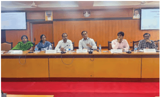
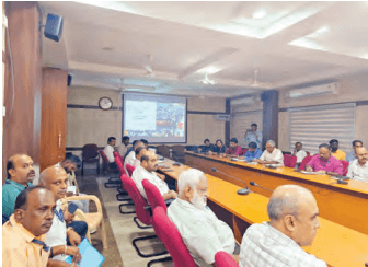
A series of stakeholder meetings were held to refine strategic approaches, ensuring balanced and inclusive growth while addressing the needs of diverse community groups. The first meeting took place on 22.10.2021, (Figure 1.4) chaired by the Principal Secretary, Housing and Urban Development Department, at the District Collectorate Meeting Hall with the line departments and the general public.
Figure 1.4: Stakeholders Discussion
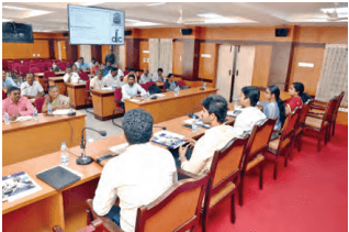
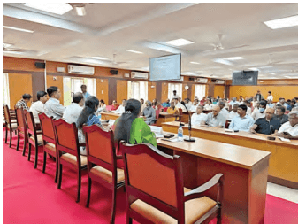
The second meeting was held on 01.12.2022, again chaired by the Principal Secretary, H&UDD, at the District Collectorate Meeting Hall with the line departments and the general public. A dedicated line department meeting was conducted on 29.03.2023, (Figure 1.5) chaired by the District Collector, at the District Collectorate Meeting Hall.
Figure 1.5: Stakeholders meeting with line departments
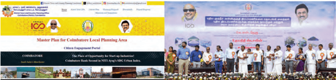
A website was also developed to get the objections and suggestions of the general public on the consented Master Plan. Then Hon’ble Minister for Youth Welfare and Sports Development inaugurated the website on 11.02.2024. (Figure 1.6). Subsequently, a stakeholders’ meeting on the consented Master Plan was conducted on 08.03.2024, at the District Collectorate Meeting Hall.
Figure 1.6: O&S Inauguration
In particular, stakeholder consultations focused on the mobility sector were conducted by the Chennai Unified Metropolitan Transport Authority (CUMTA) on 08.04.2025, (Figure 1.7) at the District Collectorate Meeting Hall, to identify traffic and transportation issues and formulate proposals. Finally, a Detailed Development Plan meeting was held from
02.05.2025 to 03.05.2025, at the Corporation Office Meeting Hall. The objections and suggestions received through online and offline, were scrutinized and duly incorporated into the Final Master Plan, further enhancing transparency and public involvement in the planning process.
Figure 1.7: Stakeholders meeting with line departments and CUMTA
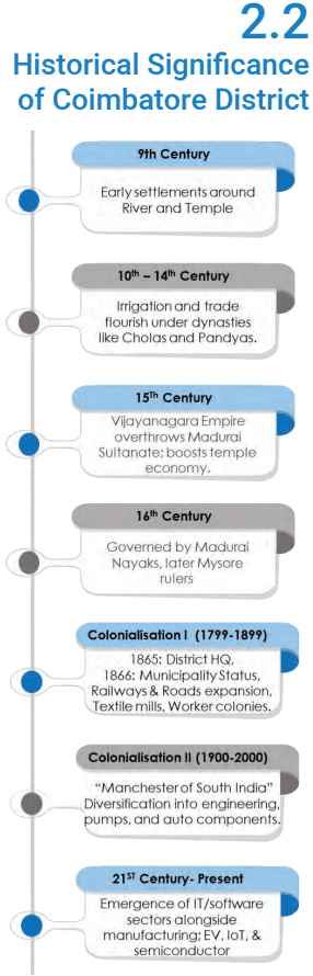
2.2Historical Significance of Coimbatore District
9th Century
Early settlements around River and Temple
10th – 14th Century
Irrigation and trade flourish under dynasties like Cholas and Pandyas.
"Manchesterof South India" Diversification into engineering, pumps, and auto components.
21ST Century- Present
Emergence of IT/software sectors alongside manufacturing; EV, loT, & semiconductor
Figure 2.1: Historical Timeline
2.2.1Historical Background
Coimbatore, originally part of the historical Kongu region, has a history dating back to the Sangam Age. Over the centuries, the region was ruled by powerful dynasties, including the Rashtrakutas, Cholas, Chalukyas, Pandyas, and Hoysalas, and later, the Vijayanagara Empire overthrew the Madurai Sultanate. Each of these rulers contributed to its growth by improving irrigation, trade, and the temple-based economy. The Madurai Nayaks governed the region before it came under Mysore rule, followed by Hyder Ali and Tipu Sultan.
Early settlements: The region’s earliest urban foundations trace back to the 9th century with established religious and agrarian communities around strategic water sources such as the Noyyal River. Temples like the Patteeswarar Temple in Perur and the Marudhamalai Temple on a Western Ghat hillock served as socio-cultural nuclei, fostering small, dispersed settlements.
However, a major shift occurred in 1799 when the British East India Company took control of Coimbatore after Tipu Sultan’s defeat in the Anglo-Mysore Wars, integrating it into the Madras Presidency.
Colonial Influence: The colonial era (post-1799) marked a pivotal shift when the British, transformed Coimbatore into a military transit hub. Colonial interventions introduced structured planning, notably in Podanur, where the first planned housing for railway employees emerged in 1799. In 1865, Coimbatore was established as the district headquarters, marking the beginning of its transformation into a major urban center. A year later, in 1866, it gained municipality status. Roads were built, and railway networks spurred linear growth along corridors like Lawley Road.
Industrial Growth and Spatial Transformation: Post-1880s industrialization has reshaped spatial dynamics- textile mills like CS&W Stanes (1887) and Laxmi Mills (1910) anchored
worker colonies, densifying areas such as Sukrawarpetta and Race Course.
By the 1930s, Coimbatore regions morphology transitioned from fragmented agrarian settlements to a cohesive industrial-administrative hub, with clusters around mills, railways, and colonial elite spaces like the Cosmopolitan Club (1914). This phased growth underscores the interplay of cultural heritage, colonial infrastructure, and industrial capitalism in shaping the city’s urban identity.
Industrial diversification and economic expansion: Following India’s independence in 1947, Coimbatore witnessed industrial diversification beyond textiles. Between the 1950s and 1970s, the city experienced the rise of small and medium-scale industries, particularly in engineering, pumps, motors, and auto components. By the 1980s and 1990s, rapid urbanization facilitated advancements in education, healthcare, and commerce. The early 20th century marked the emergence of Coimbatore as a prominent textile hub, fuelling industrial growth and economic expansion in Coimbatore. The 21st century saw further diversification, with information technology (IT) and software industries gaining prominence alongside the well-established manufacturing and textile sectors.
Thus, Coimbatore district’s transformation from an ancient trading centre to a modern industrial city reflects its resilience and sustained economic progress.
2.2.2Administrative Background and Chronological Change
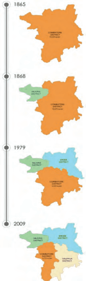
Coimbatore district’s journey from a sprawling agrarian territory to a compact economic dynamo is a testament to strategic administrative foresight. Originally encompassing 18,235 sq. km—a vast swath that included present-day Erode, Nilgiris, and Tiruppur—the district’s boundaries were reshaped over time to align with evolving economic priorities and governance needs.
Strategic Bifurcations of Coimbatore District:
1868 – Nilgiris Bifurcation: Carved out to conserve the ecologically fragile Western Ghats and promote tourism, this bifurcation allowed Coimbatore to shed its resourceextraction role and focus on industrialization.
Figure 2.2: Chronological Change
1979 – Erode’s Formation: As an agrarian stronghold (turmeric, dairy, handlooms), Erode’s creation strengthened cross-district supply chains, feeding Coimbatore’s textile mills with raw materials.
2009 – Tiruppur’s Emergence: India’s knitwear capital absorbed textile manufacturing, freeing Coimbatore to pivot to advanced sectors like engineering, IT, and education.
These administrative realignments reduced Coimbatore district footprint by 74% (to 4,732 sq. km), transforming it from a diffused agrarian-territorial entity into a concentrated urban-industrial hub. Yet, this spatial compression did not diminish its regional economic influence. Instead, it amplified synergies with neighbouring districts. Coimbatore along with the Nilgiris, Erode and Tiruppur evolved as specialized nodes in industries, eco-tourism, agriculture and textiles, creating an interconnected ecosystem where each district complimenting strength of one another.
2.4.2Rail Connectivity
Coimbatore is located on the Chennai–Coimbatore– Kochi trunk route, a vital part of the Southern Railway’s broad-gauge network. The Palghat Gap in the Western Ghats enhances this connectivity by enabling seamless rail movement between Tamil Nadu and Kerala. This corridor links Coimbatore with Chennai’s port and industrial hubs, extends towards Bengaluru, and integrates into the Bengaluru–Mumbai Rail Corridor while also aligning with Salem, Erode and Tiruppur. Westward, it connects to Kochi and the International Container Transshipment Terminal (ICTT) at Vallarpadam.
Coimbatore Junction serves as the primary rail hub, while Podanur Junction and its freight yard handle industrial cargo bound for ports like Chennai, Kochi, and Thoothukudi. Suburban stations such as Coimbatore North, Peelamedu, Irugur, and Sulur Road, further strengthen local mobility and regional freight movement, reinforcing Coimbatore’s role as a major rail node in South India.
2.4.5Cargo and Logistics
Coimbatore region owes its economic dynamism to a robust logistics ecosystem strategically integrated with national and regional connectivity corridors. Coimbatore’s industrial expertise in textiles, automotive, and electronics is anchored by an efficient logistics network comprising key highways such as NH 544, NH 948 and NH 181 where it hosts concentrated logistics parks and warehouses, enabling seamless cargo movement.
Complementing this, rail freight alleviates road congestion for bulk transport, while Coimbatore International Airport accelerates high-value exports like precision machinery, textiles, medical equipment, and perishables.
This logistical efficiency is further amplified by Coimbatore’s role in South India’s transformative regional corridors, positioning it as a critical node in the industrial and defence landscape. The Tamil Nadu Defence Industrial Corridor (TNDIC) leverages the district’s engineering expertise to bolster aerospace and defence manufacturing alongside Chennai and Hosur. The extension of Chennai–Bengaluru Industrial Corridor (CBIC) to Kochi via Coimbatore would enhance cross-state trade, linking Tamil Nadu’s industrial heartland to Karnataka and Kerala’s economic centres. The Chennai – Kanniyakumari Industrial Corridor (CKIC) in the vicinity would integrate Coimbatore
2.5 Coimbatore District Profile
with southern Tamil Nadu’s industrial nodes, fostering regional supply chain synergies.
Together, these linkages solidify Coimbatore’s stature as a logistics gateway, driving industrialization, reducing operational costs, and embedding the district into global value chains.
2.4.3Air Connectivity
Coimbatore International Airport (CJB), situated on the Avinashi Road, serves as a crucial aviation hub, facilitating both passenger travel and cargo movement. The airport plays a vital role in enhancing business, tourism, and trade, significantly contributing to the economic growth of the region.
International Connectivity: Coimbatore International Airport maintains global trade and travel links with major international destinations such as Singapore, Sharjah, Jeddah, and other cities in Saudi Arabia.And also connected to key locations in Europe, the USA and other major Southeast Asian countries through stop over linkages.
Domestic Connectivity: The airport provides seamless connectivity to major Indian cities, including Mumbai, Delhi, Indore, Kolkata, Bengaluru, Chennai, Hyderabad, Ahmedabad, and Pune, ensuring efficient movement of passengers and goods.
Identified as a special node to play a major role in the States’ vision to emerge as a One Trillion Dollor Economy by 2030, Coimbatore airport is envisaged for expansion in passenger as well as cargo handling capacities. This would strengthen its global connectivity further and enhance its commercial role significantly.
2.4.4 Water Transport Connectivity
Although Coimbatore District lacks direct water transport, it relies on nearby seaports for trade and exports. Cochin Port (approximately 200 km away) handles machinery, textiles, and engineering goods, while Tuticorin Port (approximately 350 km away) supports bulk cargo transport. Mangalore Port (approximately 400 km away) also facilitates exports from the city’s manufacturing sector. Logistics hubs, including dry ports and inland container depots, ensure efficient cargo movement to these ports.
1.7.7Report Structure
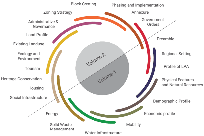
The Second Master Plan 2041 is organised in five volumes and a set of existing and proposed land use plans. The main report is covered in volumes I & II. The schedule, giving the details of land use proposed in each of the survey numbers of the LPA is given in volume III, IV and V. The chapterisation of the main report is given below:
Figure 1.8: Report Structure
REGIONAL SETTING
2.1 Overview
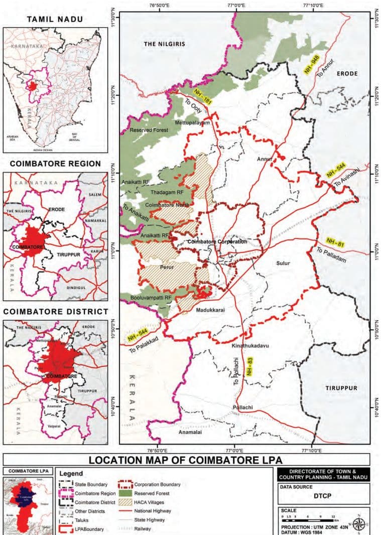
The area of Coimbatore LPA constitutes around 32.54 % of Coimbatore district and accommodates around 74% of the population of the district. It accommodates most of the economic activities as well as critical infrastructure of the district. Coimbatore District, a key economic hub in western Tamil Nadu, spans approximately 4,723 Sq.km and is strategically positioned at 11.0168° N latitude and 76.9558° E longitude.
Administratively, the district is bounded by Nilgiris District to the north, Erode District to the northeast, Tiruppur District to the east, and Dindigul District to the southeast. To the west, it shares its boundary with Palakkad and Idukki districts of Kerala. Geographically, Coimbatore district’s landscape is majorly shaped by the Western Ghats, which form its western and northern boundaries. The Palghat Gap, a natural mountain pass, plays a vital role in connecting Coimbatore with Kerala, fostering trade and cultural ties between the two states. Within this diverse landscape, the terrain ranges from dry plains in the east to lush, forested regions in the west.
At its heart lies Coimbatore City (Kovai), the Kongunadu region’s largest urban center and Tamil Nadu’s second-largest city. Coimbatore - a tier-II hub drives innovation in textiles, manufacturing, IT, healthcare, and education, while its industrial legacy endures through its dominance in pump and motor production, supplying nearly half of India’s demand.
The district’s urban fabric extends to key towns like Pollachi and Mettupalayam, supported by the Coimbatore Local Planning Area’s structured network of municipalities, town panchayats, and villages. This blend of strategic geography, economic dynamism, and planned development cements Coimbatore’s role as a vital regional hub, bridging landscapes, industries, and communities across southern India.
Map 2.1: Location Map of Coimbatore LPA
2.4.1Road Connectivity
Regional Integration & Pan India Linkages
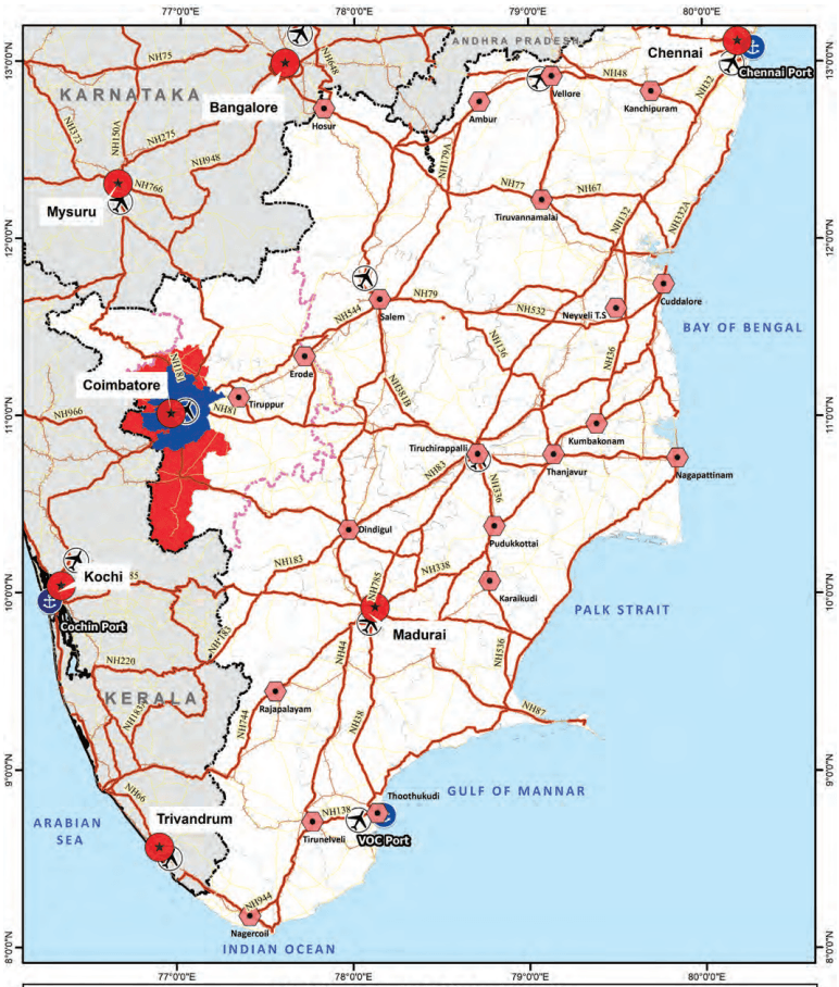
Coimbatore’s significance lies in its being at the crossroads of key economic corridors. NH 83 connects the city to Pollachi (45 km) and Madurai (211 km) integrating western Tamil Nadu with the agriculturally rich southern regions. This corridor further facilitates the movement of goods, from Coimbatore’s industrial hubs to the port city of Thoothukudi. To the North, NH 181 ties Coimbatore to Udhagamandalam (Ooty, 85 km) and Mysore (199 km), fostering tourism and cross-border trade with Karnataka. To the West, NH 544 connects Coimbatore to Palakkad (52 km).
Coimbatore’s road connectivity extends beyond regional linkages, integrating seamlessly into India’s Golden Quadrilateral (GQ) network—the country’s most critical highway system connecting Delhi, Mumbai, Chennai, and Kolkata.
The NH 544, the city’s vital north-south corridor, merges with NH 44 (part of the GQ), creating a pan-India arterial route that links Coimbatore to major economic hubs like Hyderabad and Delhi. For Kerala-bound traffic, this highway extends toward Kochi and Thiruvananthapuram enabling cross border movements. Additionally, the highway offers direct connectivity to Salem and Chennai (506 km), enhancing access to Tamil Nadu’s capital and its eastern Ports.
The NH 948 connects Coimbatore to Bengaluru (363 km) and links further to Mumbai via NH 48, which is another critical component of the Golden Quadrilateral. This strategic alignment positions Coimbatore with the Chennai-Bengaluru-Mumbai Industrial Corridor (CBMIC), offering the industries in and around the Coimbatore city, a greater access to national and international markets.
As a result, the Coimbatore region emerges as a critical stopover for goods transported between southern and western/northern markets, enhancing its role in national
supply chains. This robust infrastructure of National Highways (NH) and State Highways (SH) not only enhances intra-state mobility but also strengthens interstate and pan-India economic and social linkages.
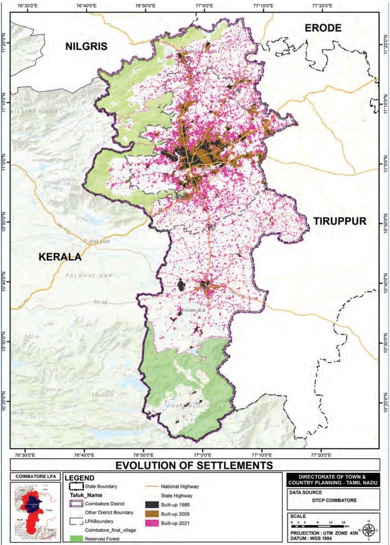
2.2.3Evolution of Settlement Pattern in Coimbatore District
The transformation of settlements in Coimbatore District, Map 2.2 illustrates a significant shift in the urban landscape from 1985 to 2021. The district has evolved from a monocentric city into a polycentric urban region characterized by multiple nodes.
1980s – Monocentric Urban Fabric: Urbanization clustered around Coimbatore City’s colonial-industrial core, predominantly within current Coimbatore South Taluk and with sparse development elsewhere. The Noyyal River and Western Ghats constrained urban sprawl, while emerging industries dotted around Sukrawarpetta and Peelamedu.
• 2000s – Radial Urban Expansion: Growth exploded along major highways (Avinashi Road and Sathyamangalam Road), creating ribbon developments. Peelamedu and
Saravanampatti emerged as education-tech hubs, while Podanur and Sulur areas industrialized.
2020s – Polycentric Urban Fabric: Infill development merged northern and southern zones into a continuous urban fabric. The dispersed growth along Avinashi Road and Sathyamangalam Road transitioned into a more continuous urban fabric. Specialized nodes that have emerged include-
North: IT parks
South: Auto clusters and logistics hubs.
West: Wellness tourism near Western Ghats and universities (e.g., Tamil Nadu Agricultural University).
East: Industries and Institutions
Thus, the settlement transformation has been shaped by industrial growth, infrastructural expansion, and the constraints imposed by natural features such as the Noyyal River and the Western Ghats.
Map 2.2: Evolution of Settlements
2.3 Natural Setting of Coimbatore
The Coimbatore region’s diverse physiography— ranging from the undulating hills in the west to the gentle eastern plains—shapes its climate, sustains rich biodiversity, and supports agriculture as well as human settlements. This dynamic interplay of terrain, weather systems, and natural resources makes Coimbatore a region of both environmental significance and scenic grandeur.
Physiographical Setting: The region’s terrain transitions dramatically from the rugged peaks of the Western Ghats in the west—home to Doddabetta Peak (2,637 MSL)—to the fertile plains in the east, with elevations ranging between 300–2,000 MSL. This varied topography supports distinct soil types, including red loamy soils and black cotton soils in the plains and lateritic soils in hilly zones. Coimbatore’s moderate tropical climate, with summer temperatures averaging 30.1°C and winter lows around 18°C, is influenced by monsoon systems, and yields an annual average of 700 mm rainfall.
Ecological Richness: Forest and Eco-sensitive areas: The western border of Coimbatore is dominated by lush forests, approximately covering 28.48% of the district, including protected areas like the Anamalai Tiger Reserve and Indira Gandhi Wildlife Sanctuary. These forests harbor endangered species such as Nilgiri Tahr, Elephants and Liontailed Macaques and is a UNESCO World Heritage-listed site. While urban expansion poses a threat, HACA regulations and Eco-Sensitive Zones (ESZ) protections help mitigate unsustainable development, preserving Coimbatore’s critical ecosystems.
Water Resources and River Basins: Coimbatore’s hydrology is sustained by three major river basins—Bhavani, Noyyal, and Amaravathi—along with reservoirs like Siruvani Dam and urban lakes such as Singanallur and Sulur. Wetlands like Ukkadam and Valankulam enhance groundwater recharge and biodiversity.
Thus, Coimbatore’s natural setting is a mosaic of ecological wealth and physiographic complexity. Balancing urban growth with the conservation of its forests, wildlife corridors, and water systems remains pivotal to ensuring the region’s environmental resilience and sustainable development.
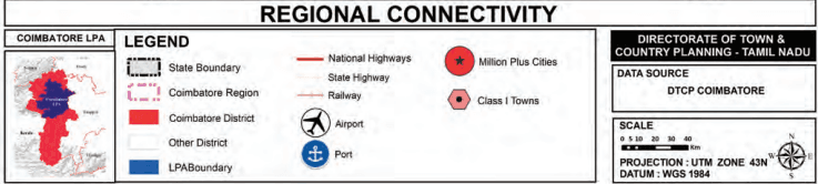
Map 2.3: Regional Connectivity
2.4 Connectivity and Regional Linkages
Coimbatore serves as a pivotal node in South India’s road network, bridging the state with Kerala, Karnataka, and Andhra Pradesh. Its well-established transport network, consisting of road, rail, air, and logistics infrastructure, strengthens regional trade, commerce, and mobility.