7.0 Development Control Zones
The entire area covered under this Land Use and Development Control Plan is divided into six Development Control Zones for the purpose of formulating the general proposal for development and use of land as well as for framing of the Development Control Regulations. The Development Control Zones are indicated in Para 7.1 to 7.6 below and are shown in Diagram Number-2.
7.1 Development Control Zone 'C'
Development Control Zone `C` comprises the areas that are used intensively for commercial activities mixed with residential and other uses. This zone also includes the areas which are likely to be used in future for intense commercial activities.
The Development Control Zone `C` consists of the following areas:
(i) The area bounded by a line drawn from the bank of river Hooghly along the northern edge of Nimtala Ghat Street, thence southward along the eastern edge of Rabindra Sarani, thence eastward along the northern edge of Vivekananda Road, thence southward along the eastern edge of Acharyya Prafulla Chandra Road and Acharyya Jagadish Bose Road, thence westward along the southern edge of Acharyya Jagadish Bose Road, thence northward along the western edge of Cathedral Road, Chowringhee Road, Jawaharlal Nehru Road, thence west-ward along southern edge of Rashmoni Avenue, Lawrence Road, and Saheed Khudiram Bose Road and a line drawn in continuation of the southern edge of Saheed Khudiram Bose Road to meet the river Hooghly and thence northward along the eastern bank of the river Hooghly to the western terminus of Nimtala Ghat Street including the plots and premises abutting the boundary described above but excluding the areas of wards Nos. 45 and 63 of Calcutta Municipal Corporation.
(ii) All plots and premises abutting the portion of the roads indicated in Schedule-I of this Land Use and Development Control Plan:
Provided that, with the previous approval of the State Government, the roads indicated in the said Schedule-I may, by notification in the official gazette, be modified as may be felt necessary in the public interest during the process of implementation of this Land Use and Development Control Plan.
7.2 Development Control Zone 'RI'
Development Control Zone 'RI' comprises the areas that are used principally for residential or industrial purposes but are mixed with other uses.
The Development Control Zone 'RI' consists of twelve parcels of land areas, the boundaries of which are given below but excludes the plots and premises abutting the roads indicated in Schedule-I.
(i) Parcel-1
The area bounded by a line drawn from the eastern bank of river Hooghly along the northern edge of Ratan Babu Road, thence southward along the western edge of Prannath Chowdhury
Lane and Rustomjee Parsee Road, thence eastward along the northern edge of Rustomjee Parsee Road, thence southward along the eastern edge of Cossipore Road, thence westward along the northern edge of Circular Canal, thence northward along the eastern bank of river Hooghly to the western terminus of Ratan Babu Road.
(ii) Parcel-2
The area bounded by a line drawn from the junction of Canal East Road and Canal Circular Road, thence eastward along the northern edge of Canal Circular Road, thence southward along the western edge of Eastern Railway line and Kankurgachi Chord, thence eastward along the southern edge of Beliaghata Canal, thence southward along the eastern edge of Pagladanga Road, thence westward along the southern edge of Debendra Chandra Dey Road, thence southward along the western edge of Mouza Bonchtola, thence westward along the northern edge of Park Circus Connector, thence northward along the western edge of Gobinda Chandra Khatik Road, thence southward along the western edge of Kankurgachi Chord, thence northward along the western edge of Pottery Road, and Radhanath Chowdhury Road, thence westward along the southern edge of Radhanath Chowdhury Road and Convent Lane, thence southward along the eastern edge of Convent Road, thence northward along the eastern edge of Eastern Railway line up to the crossing of railway line and Canal East Road, thence northward along the western edge of Canal East Road to the western terminus of the junctions of Canal East Road and Canal Circular Road.
(iii) Parcel-3
The area bounded by a line drawn from the junction of Moulana Abul Kalam Azad Sarani with the eastern boundary of Calcutta Municipal Corporation, thence westward along the southern edge of Moulana Abul Kalam Azad Sarani, thence northward along the western edge of Road No. 21, 19A and 19 of C.I.T. scheme VI-M, thence eastward along the northern edge of Road No. 14 of C.I.T. scheme VI-M, thence northward along the western edge of Motilal Basak Lane, thence westward along the southern edge of Road No. 10 of C.I.T. scheme VI-M, thence northward along the western edge of Road No. 18 of C.I.T. scheme VI-M, thence eastward along the northern edge of Satin Sen Sarani, thence southward along the eastern boundary of Ward No. 31 of Calcutta Municipal Corporation, up to the southern terminus at the junction of Moulana Abul Kalam Azad Sarani and the eastern boundary of Calcutta.
(iv) Parcel-4
The area bounded by a line drawn from the junction of Dr. Lalmohan Bhattacharjee Road and Convent Road, thence eastward along the northern edge of Convent Road, thence northward along the western edge of Canal Street, thence eastward along the northern edge of Canal Street, thence southward along the eastern edge of Canal Street, thence eastward along the northern edge of Convent Road, thence southward along the eastern edge of Convent Road, thence westward along the southern edge of Dr. Lalmohan Bhattacharjee Road to the western terminus of the junction of Dr. Lalmohan Bhattacharjee Road and Convent Road.
(v) Parcel-5
The area bounded by a line drawn from the junction of Bondel Road and Rifle Range Road, thence northward along the western edge of Rifle Range Road, Tiljala Road and Rameswar Shaw Road, thence eastward along the northern edge of Gobra Road and Gobra Goristhan Road, thence southward along the eastern edge of Mahendra Chatterjee Road, thence
eastward along the northern edge of Rammohan Bera Lane, thence southward along the eastern edge of Raicharan Pal Lane, thence westward along the southern edge of Tiljala Road, thence southward along the eastern edge of Tiljala Road, thence westward along the southern edge of Picnic Garden Road, Bondel Road to the western terminus at the junction of Bondal Road and Rifle Range Road.
(vi) Parcel-6
The area bounded by a line drawn from the junction of Hazra Road and Motilal Nehru Road, thence eastward along the northern edge of Hazra Road, thence southward along the eastern edge of Dover Terrace and Panditia Place, thence westward along the southern edge of Ashwini Dutta Road and Monoharpukur Second Lane, thence northward along the western edge of Motilal Nehru Road up to the junction of Hazra Road and Motilal Nehru Road.
(vii) Parcel-7
The area bounded by a line drawn from the junction of Prince Gholam Muhammad Shah Road and Prince Anwar Shah Road, thence eastward along the southern edge of Prince Anwar Shah Road, thence southward along the western edge of Raja Subodh Chandra Mullick Road, thence westward along the southern edge of Prince Gholam Hussain Shah Road, thence southward along the eastern edge of Prince Gholam Hussain Shah Road, thence westward along the southern edge of North Road, thence southward along the eastern edge of North Road, thence westward along the southern edge of Jadavpur Central Road and Prince Gholam Hussain Shah Road, thence northward along the western edge of Prince Gholam Muhammad Shah Road up to the western terminus at the junction of Prince Gholam Muhammad Shah Road and Prince Anwar Shah Road.
(viii) Parcel-8
The area bounded by a line drawn from the junction of Judges Court Road and Gopal Nagar Road, thence eastward along the northern edge of Judges Court Road, thence southward along the western edge of Tolly's Nullah, thence westward along the northern edge of Tollygunge Circular Road, thence northward along the western edge of Chetla Road, thence westward along the southern edge of Station Road, thence northward along an imaginary line joining Station Road and Pearymohan Roy Road over the railway line and Chetla Boat Canal, thence northward along the western edge of Pearymohan Roy Road, Rakhal Das Auddy Road and Gopal Nagar Road up to the junction of Judges Court Road and Gopal Nagar Road.
(ix) Parcel-9
The area bounded by a line drawn from the junction of Tollygunge Circular Road and Yotish Roy Road, thence eastward along the northern edge of Tollygunge Road, thence southward along the western edge of Tolly's Nullah, thence westward along the southern edge of Pashupati Bhattacharyya Road, thence northward along the western edge of Chanditala Branch Road, thence eastward along the northern edge of Chanditala Branch Road, thence northward along the western edge of Chanditala Main Road, thence eastward along the northern edge of Roy Bahadur Road, thence northward along the western edge of Yotish Roy Road up to the junction of Yotish Roy Road to Tollygunge Circular Road.
(x) Parcel-10
Calcutta Municipal Corporation Ward No. 122.
(xi) Parcel-11
The area bounded by a line drawn from the junction of Sidhya Nath Chatterjee Road and Diamond Harbour Road, thence southward along the eastern edge of Diamond Harbour Road, thence westward along the southern edge of Biren Roy Road, thence southward along the eastern edge of Sarsuna Main Road, thence westward along the southern edge of Sarsuna Main Road and Kastha Danga Road, thence northward along the western edge of Oxy Town, thence eastward along the northern edge of Biren Roy Road, thence northward along the western edge of Porui Das Para Road, thence eastward along the northern edge of Porui Das Para Road and Becharam Chatterjee Road, thence northward along the western edge of Becharam Chatterjee Road, thence eastward along the northern edge of Sidhya Nath Chatterjee Road up to the junction of Sidhya Nath Chatterjee Road and Diamond Harbour Road.
(xii) Parcel-12
The area bounded by a line drawn from southern bank of river Hooghly along the western edge of Tolly's Nullah, thence southward along the western edge of Karl Marx Sarani, thence southward along the western edge of Diamond Harbour Road, thence westward along the southern boundary of Calcutta Municipal Corporation Ward No. 80, thence northward along the western boundary of Calcutta Municipal Corporation Ward No. 80, thence westward along the southern edge of Garden Reach Road, thence northward along the western edge of Lenin Road and a line drawn in continuation of Lenin Road to meet the river Hooghly, thence eastward along the southern bank of river Hooghly to the western terminus of Tolly's Nullah.
7.3 Development Control Zone 'R'
Development Control Zone 'R' comprises the areas that are principally used for residential purpose mixed with other uses. This zone includes the areas which are likely to the developed for residential purpose in future.
The Development Control Zone 'R' consists of those areas of Calcutta Municipal Corporation which are not included in the Development Control Zone 'C', 'RI', 'M', 'UA' and 'RF' as described under Para 7.1, 7.2, 7.4, 7.5 and 7.6 of this Land Use and Development Control Plan.
7.4 Development Control Zone 'M'
Development Control Zone 'M' comprises the Calcutta Maidan Area, the boundary of which is as under:
A line drawn from the eastern bank of the river Hooghly from a point on the river bank formed by the extension of the southern edge of Saheed Khudiram Bose Road to meet the river Hooghly, thence eastward along the southern edge of Saheed Khudiram Bose Road, Lawrence Road and Rashmoni Avenue, thence southward along the western edge of Jawaharlal Nehru Road, Chowringhee Road and Cathedral Road, thence westward along the southern edge of Acharyya Jagadish Bose Road, thence northward along the western edge of Kidderpore Road and Red Road, thence westward along the southern edge of Lawrence Road and Gostha Pal Sarani and a line drawn in continuation of Gostha Pal Sarani to meet the river Hooghly, thence northward along the eastern bank of river Hooghly to the western terminus of the line in continuation of the southern edge of Saheed Khudiram Bose Road to meet the river Hooghly. The area shall exclude the portions of Maidan covered by the Ward Nos. 45 and 63 of Calcutta Municipal Corporation.


LAND USE AND DEVELOPMENT PLAN
FOR CALCUTTA MUNICIPAL CORPORATION AREA
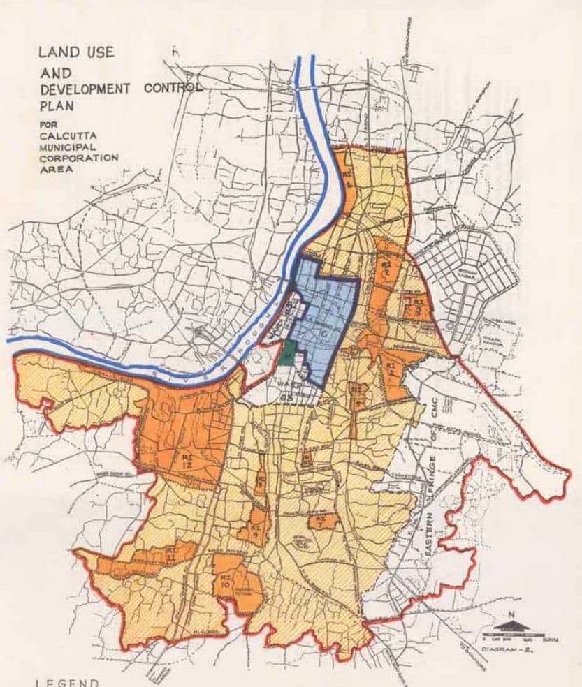
LEGEND
MUNICIPAL BOUNDARY
DEVELOPMENT CONTROL ZONE-M
RAILWAY LINE
DEVELOPMENT CONTROL ZONE - C
MAJOR ROAD
REVELOPMENT CONTROL: ZONE > RI
7.5 Development Control Zone 'UA'
Development Control Zone 'UA' comprises the following areas:
(i) The areas required for the functioning of the Calcutta Port;
(ii) The areas covered by all railway-yards within Calcutta Municipal Corporation area including vacant land and ponds under the control of Indian Railways adjoining these railway-yards.
7.6 Development Control Zone 'RF'
Development Control Zone `RF' comprises the following four parcels of land:
(a) A 15.00 metres wide strip of land on the east of the river-bank between Pramanick Ghat Road on the north and Circular Canal on the south,
(b) The strip of land between eastern boundary of Circular Rail on the east and the river on the west between Circular Canal on the north and Port Commissioners Road leading from the river Hooghly up to Mahatma Gandhi Road on the south,
(c) The strip of land between eastern boundary of the Circular Rail on the east and the river on the west between Rabindra Setu on the north and Tolly's Nullah on the south excluding the portion falling within Ward No. 45 of Calcutta Municipal Corporation.
(d) A 15.00 metres wide strip of land adjoining the river between Tolly's Nullah to the limits of Calcutta Municipal Corporation excluding the portion falling within the Calcutta Port area.
