5.0 Relationship with Neighbouring Areas
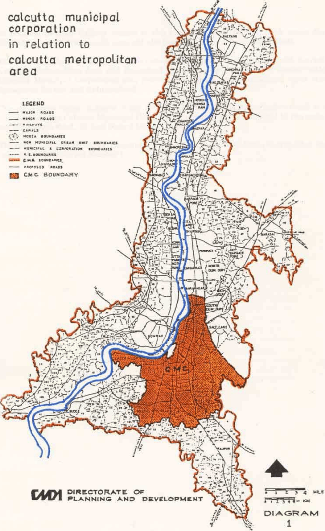
The Calcutta Municipal Corporation is the nucleus of the Calcutta Metropolitan Area, the largest conurbation of human settlement in India spreading over the two banks of the river Hooghly. The Calcutta Metropolitan Area is the principal urban centre of a vast hinterland extending over the whole of eastern and north-eastern India. Some of the key functions related to development of the whole country that Calcutta performs are:
(i) acting as a national centre of economic activities like industry, trade and commerce;
(ii) acting as the main capital market for the entire eastern region;
(iii) functioning as a very important regional, national and international node for traffic and transport, both passenger and goods;
(iv) providing the location for regional headquarters of several Central Government Organisations;
(v) acting as an important centre for higher education, specialised health services and cultural & recreational activities;
(vi) providing a principal centre for the eastern region as well as the nation for utilization of human potential in high technology and modern methods of research and development;
(vii) acting as the gateway to international tourist traffic from south-east Asia.
The Calcutta Municipal Corporation area is connected with the remaining areas of Calcutta Metropolitan Area and the hinterland by a number of regional and arterial roads including:
(i) Barrackpur Trunk Road;
(ii) R.G Kar Road—Khudiram Bose Sarani – Jessore Road;
(iii) B.N. Dey Road;
(iv) Kazi Nazrul Islam Avenue;
(v) Raja Subodh Chandra Mullick Road – Garia Main Road;
(vi) Diamond Harbour Road;
(vii) Budge Budge Road.
The Calcutta Municipal Corporation area was connected with the west bank of the river Hooghly by only one direct road link through the Rabindra Setu. With the completion of the 2nd Hooghly Bridge, the Calcutta Municipal Corporation area now has another direct road link with the areas on the west bank of river Hooghly.
The Calcutta Municipal Corporation area is connected with the remaining areas of Calcutta Metropolitan Area and the hinterland by the suburban railway network. The following suburban railway lines operate from the Sealdah Railway Station:
(i) Sealdah - Ranaghat Line;
(ii) Sealdah - Bongaon Line;
(iii) Calcutta Chord Railway link connecting Sealdah and Dankuni;
(iv) Sealdah – Lakshmikantapur Line;
(v) Sealdah - Diamond Harbour Line;
(vi) Sealdah – Canning Line;
(vii) Sealdah - Budge Budge Line.
calcutta municipal corporation in relation to calcutta metropolitan area
LEGEND
— MAJOR ROADS
— MINOR ROADS
— RAILWAYS
— CANALS
1 MOUTA BOUNDARIES
— NOH MUNICIPAL DREAM UNIT BOUNDARIES
—— HUMICIPAL & CORPORATION EODOARIES
---- R. S. BOUNDARIES
CMS BOUNDABLES
— PROPOSED ROADS
CMC BOUNDARY
In addition Sealdah Railway Station is also connected with the west bank across the river Hooghly through Vivekananda Setu and also through a railway bridge at Naihati.
The river Hooghly is the main link of the Calcutta Municipal Corporation area with the rest of the Calcutta Metropolitan Area and hinterland by water. The Calcutta Port located within the Calcutta Municipal Corporation area provides the inland and international water transport linkages of the city and its hinterland.
The air transportation linkages of the area are provided by Calcutta Airport which is within 10 kms. from the Calcutta Municipal Corporation boundary and is connected by two main roads viz. (1) Jessore Road, (2) Kazi Nazrul Islam Avenue.
The entire Calcutta Municipal Corporation area in the context of Calcutta Metropolitan Area has been shown in Diagram Number 1.