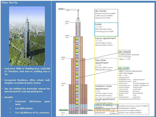
5.2.1 Location
Location attributes to be considered in a planning exercise:
a) Location in terms of latitude and longitude, population size and area and connectivity with other settlements etc.
b) Nodal significance in the national or regional transport and communication network, power network and industrial development etc.
c) Location in terms of agricultural produce collection and distribution centre, agro-industries linked to local markets, irrigation network, agricultural extension services etc.
d) Status that the settlement in hierarchy in the State or the Region
e) Role and status of the city/ town in the national delivery systems of social services;
f) Relative significance of locations of city/ town in proximity to a Metropolitan/Megapolis:
i. Nodal significance
ii. Presence of high productive economic activities
iii. Presence of large scale market
5.2.2 Site
Site attributes to be studied for planning exercise:
a) Conditions of site: low-lying, swamp, or dry land, ridge, on a riverbank or canal side. Within the town-flat, slopping (in which direction), undulating-gentle slope, moderate slope, steep slope.
b) Value and importance of the site and its historical past, that is, when the nucleus was established.
c) Analyse the factors responsible for determining the site:
i. In alluvial plains
ii. In hilly and mountainous regions
iii. In arid regions
iv. In the areas of territorial ruler ship
v. In the areas around some localised physical resources, mining settlements, manufacturing towns, resort towns
vi. Around large metropolis
d) Climate and its influence on daily life, construction, range of crops and how the city activities have modified the natural climate, particularly in the built-up area.
e) Analysis of climate type, variations in temperature, wind velocity and wind directions in different parts of the city; study of the climate with reference to summer, rainy and winter seasons.
f) Limiting and the favourable factors of site in the spread and growth of the city/town.
5.2.3 Situation
The following to be considered for situation analysis:
a) The endowment of the situation (wider setting) for the subsequent growth in size of the city/town and for the enhancement of its functions
b) The important and interrelated aspects of situation, namely,
i. Physical configuration
ii. Route patterns
iii. The extent of the territory to which the urban functions are related
c) Suggest measures to retard or even overcome the weakening of the original value of the site and situation.
5.2.4 Hinterland
The endowment of the hinterland is another factor on which growth of an urban centre rests. An urban centre, for example, can establish a mutually interacting relationship with its hinterland if the hinterland has a variety and extent of natural resources in terms of both agriculture and economic potentials. A city's growth may be consistent and stable mainly because its economic base is closely linked with that of its hinterland. It is also conceivable that the city can be an instrument not merely for effectively utilising the existing potential of its hinterland but also of increasing the hinterland's potential itself. The development of the regional economy helps the growth of small towns, which in the process become the main service centres for their hinterlands.
Therefore, considerable attention should be given to the delimitation, functionality, social and economic link to a particular urban settlement. The area linked socially and economically to an urban settlement has been given various names, such as “Hinterland”, “Upland”, “Urban Field”, “Sphere of Influence”, “Zones of Influence”, “Tributary Area”, or “Catchment Area”. The immediate hinterland of a large city, which is directly under the influence of the agglomeration, is the ‘peri-urban area’.
5.2.4.1 Peri-urban area
The area influenced by a town is not a two-dimensional feature, not a sphere, nor does it necessarily form a continuous zone. Flow of goods, services and information into and
out of a town/city: most modern urban settlements and their immediate hinterlands are economically interdependent, rather than one being a tributary to the other. An analysis of the rural area served by a city/town gives some indication of the relation between city and the urban-rural mix (the peri-urban area), which is of practical application in examining the provision of goods and services in an urban centre. However, as mentioned in the Regional planning chapter, Peri-urban is the zone which is within the planning area limits but outside the limit of the municipal corporation / authority or metropolitan planning committee or authority.
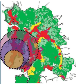
As smaller towns fall within the areas served by larger metropolitan regions, the delimitation of urban zones of influence also sheds light on the manner in which a city at a particular level in the urban hierarchy provides specialist services for the surrounding population and settlements (such as service towns, satellite towns or service villages). Finally, very large cities extend a particularly intensive influence over the areas around them; so much so that these can be well defined peri-urban areas. Delimitation of peri-urban areas is directly influenced by accessibility as of highways and/or prime economic investments. With rapid urbanisation conditions, the peri-urban zone is dynamic. Hence peri-urban limits undergo alterations subject to high stress for urban growth and therefore always in fast transition.
In examining zone of influence, one commonly adopted method is to establish on a map the areas served by employment, shopping, entertainment, education, health services and so on. This method of analysis is applicable to cities and towns at all level in urban hierarchy. At a higher level in urban hierarchy the criteria used reflect the distinctive functions of larger settlements and employ information like:
5.2.5 Accessibility
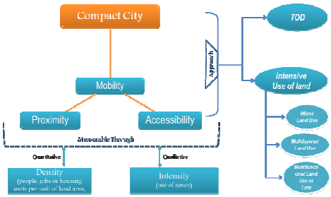
Accessibility is the dominant factor influencing the location, growth and functions of urban centres. It is to combine at least three elements: the location of a place within a region (in general, centrally located places are more accessible); the form of the transport system; and accessibility within the area of the activities: access to employment opportunities, access to population, access to educational or health facilities, etc.
¹ Sustainable Urbanization: Guidelines to Manage Urban Growth, Volume 2: Tools and Guidelines, McIntosh Xaba& Associates.
Urban settlements tend to grow on transport routes only at specific places, particularly at junctions and break-of-bulk points, where one form of the transport is changed for another. Hence settlements whose locations are guided by transport routes are found not only at the end of these routes, but also along them. The number of routes, which come together at a particular point, is important, but the degree to which passengers and goods are interchanged is more important.
The guidelines for the study of accessibility are as under -
Establish the role of:
i. Long-distance regional/inter-regional transportation in determining the locations of the city/town;
ii. Both the long distance as well as local and intra-urban transportation in the growth of size of the city/town;
iii. Inter-urban and intra-urban transportation in affecting urban structure.
iv. Inter-regional easy access by different modes;
v. Good mobility within city/town due to construction of tunnel results in the development of new areas with commercial, industrial and residential activities, which leads to population increase in the entire urban area.
5.2.6 Socio-Economic Profile
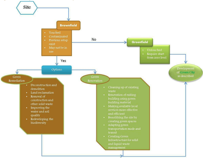
City is not alone a characteristic of its physical or locational forms; its population and its characteristics determine the social processes that set the City culture. Socio-economic class-wise distribution of the population is a key indicator of the social parameters in a settlement. In case of existing settlement, the pattern of population on the basis of socio-economic levels can be studied for planning to understand the services and facilities. On the contrary, it is useful for the greenfield sites, where zoning can be proposed based on the income of the settling population class, higher, middle or low. Spatial plan is usually influenced by living and work places of different of population classes.
This principle of Urban Strategic Planning ² should in consonance with the income distribution structure of the city region with the urban poor located near public transport nodes/links and specially providing space for the urban poor in master/development plans for living, selling and working - at city, zone and local levels.
Overall, the social indicators allow the planner to understand the city, link it with the city spatial form and its behaviour pattern. In short, unlike the traditional approach to zoning, social parameters can be used for creating zones and its functions. This can directly point at the urban facilities such as bus services, dedicated transportation corridors, facilities of social infrastructure and physical infrastructure.
² Report of the Working Group on Urban Strategic Planning, 12 th Five-year Plan'