5.3.1 Developed Area Average Densities
For the purpose of these guidelines, the densities mentioned in this section are the Gross Population Densities defined as person per unit area (in hectares) for developed area only. The calculation includes population of the settlement on the developed land of the settlement.
Fixation of density norms should be based on carrying capacity analysis focusing on parameters - space per person, access to facilities, available piped water per capita, mobility and safety factors. The task should be settlement specific. However, for overall planning approach density ranges are suggested in Table 5.1.
| Persons per Hectare(pph) in | ||
| Settlement Type | Plain Areas | Hill Areas |
| Small Towns | 75-125 | 45-75 |
| Medium Town | 100-150 | 60-90 |
| Large Cities | 125-175 | 60-90 |
| Metropolitan Cities | 125-175 | 100-150 |
| Megapolis | More than 200 | -- |
Source: Revised based on UDPFI Guidelines.
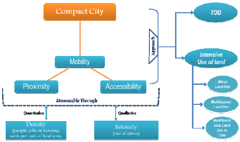
These are suggestive population densities as per the settlement size. However, while planning for compact and TOD development, these densities should be modified to suit the requirement and should be based on carrying capacity analysis. Developed area densities suggested above is useful to calculate total developed area requirement at city level, when the target population for the city is given. When used along with the suggested norms for different land use, area can also be calculated.
5.3.2 Proposed Land use Structure of Urban Centres
The proposed land use structure for urban centres is indicated in Table 5.2:
| Percentage of Developed Area | |||||
| S.No. | Land use Category* | Small | Medium | Large Cities | Metropolitan Cities & Megapolis |
| 1 | Residential | 45-50 | 43-48 | 36-39 | 36-38 |
| 2 | Commercial | 2-3 | 4-6 | 5-6 | 5-6 |
| 3 | Industrial | 8-10 | 7-9 | 7-8 | 7-8 |
| 4 | Pub. & Semi Public | 6-8 | 6-8 | 10-12 | 10-12 |
| 5 | Recreational | 12-14 | 12-14 | 14-16 | 14-16 |
| 6 | Transport & Communication | 10-12 | 10-12 | 12-14 | 12-14 |
| 7 | Agriculture, Water bodies and Special areas | Balance | Balance | Balance | Balance |
| 8 | Total Developed Area | 100 | 100 | 100 | 100 |
Source: Revised based on UDPFI Guidelines, 1996
Note:
-
It would be desirable to fix the recommended Landuse share for essential uses (Residential, Transportation and Recreational) while the proportion for other uses may be flexible. Actual land use percentage in a given city case should be calculated based on local conditions and needs.
-
Zoning regulations given in Table 9.1 – ‘Simplified land use classification’ to be followed in consistency with the land use structure given in the table above.
-
*Land occupied under Special Areas (refer Table 9.1 for uses) to be included in the land use categories 1-6 given in the table above, unless large special areas to be considered as a separate entity for planning, such as cantonment areas.
-
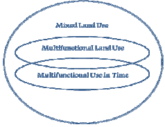
*However, to propose the mixed land use of a city –percentage share of residential, commercial and industrial land use to be adjusted proportionally as planned by the local authority. Mixed land use should be either non-industrial oriented or industrial mix oriented (refer Table 9.1 for uses).
-
The adjustment in the residential, commercial and industrial land use (dominant use) to be based on the land area proposed for mixed land use zone and reduction of respective proposed mixed land use(s). Appropriate reduction in residential, commercial or industrial uses and adjustments in other uses to be made so that the total land use becomes 100%. The mixed use of land to be envisaged at vision development stage of the plan formulation.
-
Detailed study is to be undertaken on the co-relation of and effects of FAR/Densities in our towns (both small towns and metropolitan cities) and guidelines to be adopted for the optimal use of land.
Specific attention needed on areas in urban planning approach.