The third part provides detailed development control norms for different types of development and use premises, mixed use provisions, Transferable Development Rights and other controls.
x
1.1 Introduction
Delhi is one of the world's oldest continuously inhabited cities, with a rich history spanning over a millennium. As the capital of India, it has evolved through successive phases of development, creating a distinctive urban fabric that harmoniously integrates heritage, culture and modern urban development. From its historic settlements to planned urban extensions and contemporary developments, the city reflects India's diverse civilizational and architectural legacy.
Today, Delhi is the nation's political, administrative, economic and cultural capital, and a globally connected metropolitan city. As the city continues to grow, it faces the challenges of accommodating a rising population, limited land availability, climate change and evolving economic aspirations, while preserving its heritage and enhancing the quality of urban life.
The Master Plan for Delhi (MPD)-2047 provides a long-term framework to guide the city's sustainable and inclusive growth. It envisions Delhi as a liveable, resilient, connected and globally competitive capital through new spatial planning policies for greenfield development and the regeneration of brownfield areas, supported by efficient land use, sustainable mobility, quality infrastructure, environmental sustainability, digital transformation and citizen-centric governance, while preserving its unique historical and cultural identity.
1.3National Capital Territory of Delhi
New Delhi is the seat of the Central Government, being the capital of India. Delhi has been given special status as the National Capital Territory of Delhi (NCTD). The NCTD has an area of 1483 sq.km and comprises of local bodies operating in defined jurisdictions. There are 357 villages in Delhi and has been divided into 17 Planning Zones (refer Map 2) for ease of planning and management. Master Plan provides strategies that converge the responsibilities and actions across these multiple jurisdictions to guide the future growth of the city.
The NCR acts as the consumption and distribution centre for North India, accounting for about 8% of the National GDP, with Delhi’s contribution being more than 50%. Delhi is one of the major trade hubs in North India and a key redistribution centre due to the seamless connectivity and robust infrastructure. In future, functions of distribution and re-distribution may shift from Delhi to the upcoming dedicated freight and logistics nodes in NCR. However, Delhi will retain its economic prominence as a front for business, trade and digital logistics, and as the primary driver of the regional economy.
Delhi metro has emerged as the lifeline of urban mobility in Delhi-NCR region and is the largest metro network in the country, with 303 operational stations, having a total network of 416 km (2026). The network is set to expand further with nearly 104 km under construction and 175 km under planning to further strengthen seamless, sustainable and high capacity public transport across the region. The Regional Rapid Transit System (RRTS) has further strengthening the regional mobility patterns and dynamics by bringing cities like Ghaziabad, Meerut, Gurugram, Panipat, Karnal, Faridabad, and Rohtak within accessible distance.
Delhi’s future role is planned as a megacity that offers a spectrum of choices for recreation, work, residence and also in conserving its natural and ecological assets to sustain the future population and development activities.
1.2Regional Context
National Capital Region (NCR) is the largest metropolitan region in the country, spread across 55,000 sq.km approximately, comprising of National Capital Territory of Delhi (NCTD), 14 districts of Haryana, 8 districts of Uttar Pradesh and 5 districts of Rajasthan. The area under the NCR has increased since Regional Plan 2001 (notified in 1989).
For harmonised and planned development of the NCR, the National Capital Region Planning Board (NCPRB) is mandated to prepare the Regional Plan and the Functional Plans, to arrange for the preparation of Sub-Regional Plans and Project Plans by each of the participating States and the Union territory, and to co-ordinate the enforcement and implementation of the Regional Plan, Functional Plans, Sub-Regional Plans and Project Plans through the participating States and the Union territory, so as to avoid any haphazard development of the region. The NCR Regional Plan proposes 4 policy zones:
(i) NCT Delhi: The area of NCT Delhi has and shall remain static at 1483 sq.km. NCT Delhi is surrounded by the NCR States from all sides and has no possibility of horizontal expansion like other parts of NCR.
(ii) Central National Capital Region (CNCR): CNCR area is now being redefined as the area from the boundary of NCT Delhi to the Eastern Peripheral Expressway (EPE) and Kundli-Manesar-Palwal expressway (KMP) up to 5 Km beyond outer edge of the ROW of this first ring of expressways (Circular Regional Expressway-I i.e. CRE-I).
(iii) Highway Corridor Zones (HCZ) and Transit Oriented Development (TOD): To prevent unplanned development along major transport corridors and to harness the development potential of these connectivity alignments, Highway Corridor Zone (HCZ) were proposed in the past plans to enable planned development within 500 metres on both sides of the highways. Now, with the development of Metro rail network, Rapid Rail Transport Systems and expressways, these connectivity corridors and the transit nodes therein, provide unique opportunities for intensive development along these corridors which will also facilitate ease of transport, reduce transportation costs and improve quality of life for much larger population than originally planned by these connectivities.
(iv) Rest of NCR: All other areas in NCR not covered by any of the above zones shall form the Rest of NCR Zone.
1.5Plan Preparation
In order to establish the present situation and assess gaps under various sectors, a baseline exercise was conducted for MPD, involving the relevant stakeholder agencies from central, state and local governments. Data was collated from primary and secondary sources and studies were conducted for transport, public transport accessibility, economy, heritage and unplanned settlements. A number of experts gave inputs towards different sectors and aspects of development in Delhi. The baseline report and analysis of the strengths, weaknesses, opportunities and threats brought to the fore key concerns regarding the city. These were corroborated by views and vision statements received from citizens, stakeholders and experts who participated in public consultations and focus group discussions held during Plan preparation.
As part of the baseline, a review of the Master Plan for Delhi (MPD)-2021 was carried out to trace the trajectory of Delhi’s development for the last two decades. MPD-2021 was reviewed in detail in order to extract lessons from its implementation.
The opinions, views and aspirations of the people of Delhi were garnered during the preparation of the Plan through continuous engagement with Civil Society Organisations (CSOs), RWA federations, market associations, professional bodies, etc., as well as through direct interaction with citizens. Dedicated online public consultations were held, during September-November 2020, including sessions with youth, persons with disabilities, professionals, NGOs working on gender issues, people living in unauthorised colonies (UCs) and slums, traders, industry representatives etc. Vision statement for this Plan was formulated through citywide consultations, focus group discussions, an online web portal and social media.
The draft Master Plan was placed in the public domain for 75 days in June, 2021 for inviting suggestions/objections after the approval of the Authority and the Ministry of Housing and Urban Affairs (MoHUA), Government of India. The draft document included ‘Service Plans’ provided by the respective service providing agencies as an Annexure. More than 34,000 objections / suggestions were received. In October, 2021, the Board of Enquiry and Hearing (BoEH) was appointed. The Board heard representations on the objections / suggestions received on draft document and gave recommendations for modification of in the draft plan. The document of Master Plan has incorporated (i) relevant suggestions/objections received from various departments/agencies of Central/State Government and the public; (ii) recommendations of the Board; and (iii) inputs from the Ministry.
1.4Evolution of Master Plans (1962, 2001 and 2021)
The process of planned development of the National Capital began with enactment of the Delhi Development Act 1957, followed by the promulgation of the Master Plan of Delhi in 1962 (MPD-1962).
The MPD-1962 set out the broad vision for the development of Delhi through planned urban development by introducing statutory land use planning, large-scale land acquisition. The aim of the Plan was to ensure that the spatial pattern of development and use of land could conform to the development plan and infrastructure and services could be laid out to match the same. This Plan envisaged urban area of approximately 45,000 hectares to accommodate a projected population of 50 lakh by 1981.
The Master Plan for Delhi 2001 (MPD-2001), notified on 1st August, 1990, also substantially reiterated the planning process, which had been outlined in MPD-1962. MPD-2001 focused on Delhi to be planned as an integral part of its region, maintaining ecological balance, treating Central City Area as a Special Area, conserving urban heritage, decentralisation of City centre, urban development to be low-rise, high density and hierarchical. This Plan marked a shift towards planned urban expansion by extending by about 18,000 to 24,000 hectares for urbanisation and promoting the development of new sub-cities, including Rohini, Dwarka and Narela. The Plan projected a population of 130 lakh.
The Master Plan for Delhi 2021 (MPD-2021), notified on 7 t h February, 2007, was an extensive modification of the respective previous Master Plans which provided a holistic framework for planned development outlining several innovations and reform were envisaged in the prevailing land policy and facilitating public - private partnerships. Together with planned development of new areas, a major focus was on incentivising the recycling of old, dilapidated areas for their rejuvenation. The Plan provided a mechanism for the restructuring of the city based on mass transport, redevelopment and densification of the existing urban areas and city improvement. It called for a comprehensive redevelopment strategy for accommodating a larger population, strengthening of infrastructure facilities accompanied by creation of more open spaces at the local level by undertaking measures for redevelopment of congested areas. The envisaged projected population for this Plan was 230 lakh.
MPD-2021 recognised the need to facilitate participation of private sector in the development process in order to overcome challenges associated with land acquisition and improve efficiencies in land consolidation and development. It introduced innovative concepts like alternate methods of land assembly, private sector participation, flexible land use, development norms and transit-oriented development. The Land Pooling Policy for development through assembly of privately owned lands was notified in 2013 and consequently its modification and Regulations were notified in 2018. Transit Oriented Development (TOD) was introduced in 2015 to restructure the city around mass transit stations nodes. Rejuvenation of old, dilapidated areas through incentives was also envisaged as part of the plan.
1.6Existing Scenario
1.6.1 Demography
Delhi is a preferred city in terms of employment, higher education and residential purposes. According to the Census of India, NCT of Delhi recorded high decadal population growth rates of 52.44%, 52.91%, 52.98%, 51.45%, 47.03% and 21.20%, from 1951 to 2011 respectively. The growth rate has dropped in the last two decades both in terms of natural
growth and migration. However, in absolute numbers, NCT of Delhi accounts for about 1.39% of India’s population and is one of the most populous cities in the world.
As per the Economic Survey of Delhi 2019-20, 30.3% of the population is in the age group of 15-30 years, making Delhi one of the cities with the highest young population in the world. With a high literacy rate (86.2%), Delhi also has a large educated workforce with about 1.1 million people between 15-59 years of age (2011). Creating opportunities for education, skill development and employment is required. Close to 30% of Delhi’s population comprises of children and young people of 0-18 years (Economic Survey of Delhi, 2019-20) age group indicating that Delhi should become a more child friendly city. It is, thus, imperative to provide infrastructure for children of all age groups and all abilities in the city.
Census 2011 recorded nearly 2.26 million migrants who had been residing in Delhi for a duration of 0-9 years. However, during the decade 2001-11, the total migration into Delhi has reduced. The Delhi Economic Survey Report ascertains that substantial migration was from neighbouring states. The absolute number of migrants are high and a comprehensive understanding of their profile, purpose and duration for migration is critical in provision of housing, facilities and employment. Over the last decade, the total migration into Delhi has reduced due to the increase in employment opportunities in Gurgaon, Faridabad, Sonipat, Noida, Ghaziabad, etc., and various employment promotion programmes by central government and respective state governments.
As per Census of India (2011), Delhi has more than 97% urban population. The density of the population has increased from 6,352 persons per sq.km in 1991 to 11,320 persons per sq.km in 2011. Delhi’s population was considered as per the high, medium and low growth scenarios respectively. The Total Fertility Rate (TFR) of Delhi in 2018 was 1.5 and observing the past trends it can be said that in future it would continue to decline (Study on Population, Economy and Employment for Delhi: MPD-2041 by Institute of Human Development). TFR of 1.5, 1.3 and 1.1 was considered for the population projections in the high fertility, medium fertility and low fertility, scenarios respectively. Considering the decline in rate of growth in the last two decades, the medium growth scenario (29.2 million) has been adopted. This may need recalibration once the Census is updated. The population estimates for NCTD at five-year intervals are given in the following table:
Table 1.1Five-yearly estimates of projected population for Delhi
Sl. No.
Year
Male (in million)
Female (in million)
Total (in million)
1.
2021
11.1
9.5
20.6
2.
2026
12.2
10.4
22.6
3.
2031
13.4
11.4
24.8
4.
2036
14.6
12.3
26.9
5.
2041
15.9
13.3
29.2
Source: Demographic projections undertaken for MPD-2041 (Study on Population, Economy and Employment for Delhi: MPD-2041 by Institute of Human Development)
Delhi’s population is estimated to be 32 million for the year 2047 based on the above projections. Two important shifts are likely in the demographic profile of the city. A significant increase is projected in the proportion of persons of working age (age group 25-60 years), employment opportunities are required to harness the potential economic benefits presented by this demographic dividend. The analysis also indicates increase in the proportion of persons in the age group of 60 years and above.
The previous Plan estimated 50% of the population increase due to migration. The growing needs of existing population and high land values have led to the growth of unplanned settlements in the city. Migration is estimated to contribute 41% of the population increase during the present Plan period.
(ii) Economy:
Delhi is one of the fastest growing metropolitan centres in the country. As per the Economic Survey of Delhi, 2025-26 the projected Gross State Domestic Product (GSDP) of NCT of Delhi is Rs. 13,27,055 crores showing the growth of 9.42 % over the previous year which is roughly 2.5 times higher than the national average. The economic profile of the city is dominated by the tertiary sector, which presently contributes the largest share to the Gross State Domestic Product (85%), followed by the secondary (12%) and primary sectors (3%).
Various Commercial centres under various hierarchy of development on approximately 2,500 Ha land has been developed by government from time to time. 2,774 Ha of industrial planned area forms a large portion of Delhi’s land use distribution accommodating industrial units of the capital city. Delhi has retail, wholesale and warehousing facilities spread across the city.
The current landscape of Delhi is characterised by a dominance of micro, small and medium enterprises (MSMEs), limited large-scale manufacturing and a gradual shift toward cleaner and service-linked industries. The city has about 29 planned industrial areas and 25 non-conforming industrial clusters. Delhi’s industrial sector growth is driven by sectors such as food processing, fabricated metals, chemicals and transport equipment, with some traditional industries like apparel and electronics.
It is the seat of government and quasi-government institutions and headquarters of various National and Multinational organisations. It is a premier Meetings, Incentives, Conferences, and Exhibitions (MICE), travel and hospitality business destination. The city also has a rich heritage that can be leveraged for promoting cultural activities such as tourism, travel, food & beverages, and creative arts, media, design, etc.
The construction sector is further expected to grow due to implementation of land pooling and various other development strategies. Transit-oriented development and strong regional interdependencies will also generate employment in the transport, trade and retail sector.
1.6.2Sectors
(i) Environment:
Delhi has an abundance and variety of environmental assets in the form of river Yamuna, Aravalli Ridge, water bodies, forests etc., as well as human-made assets like parks, maidans, ponds, baolis, etc. All the assets and their inter-connected network provide open spaces for citizens, facilitates larger network benefits for biodiversity, micro-climate and flood management. However, these environmental assets also grapple with concerns like pollution, encroachment and environmental degradation.
Air and water pollution have a large geographical footprint. A large fraction of air pollution in Delhi comes from outside its geographical boundaries, therefore regional level action is necessary and multi-state efforts are required for addressing these issues comprehensively. The major contributors of indigenous pollution are: industries and transport in winters; dust and industries in summers. Rest is emissions from households, waste burning and diesel generator sets.
Among Delhi’s well-endowed blue assets, the most significant is the River Yamuna that has a historic, cultural and spiritual connect with the city. The city has an extensive network of natural and constructed drains, largely spread across three drainage basins of Najafgarh, Trans-Yamuna and Barapullah. Water pollution in the Yamuna and other water bodies has resulted in disappearance of aquatic life and disturbed the water ecology. The 22 km stretch from Wazirabad to Okhla, which is less than 2% of the total river length, accounts for about 76% of the pollution load in the river. Despite being a perennial river, the Yamuna has no freshwater flow downstream of Wazirabad in the dry season [Source: Action Plan by River Rejuvenation Committee (RRC), GNCTD]. The flow in the river comprises of treated and untreated wastewater flowing through drains that fall into the river. Delhi Pollution Control Committee (DPCC) monitors major drains (refer Annexure 2) that are responsible for most of the polluted outflow in the river. Any strategy for river management will also have to consider the activities in the floodplains, to prevent ecological damage and potential flood hazards.
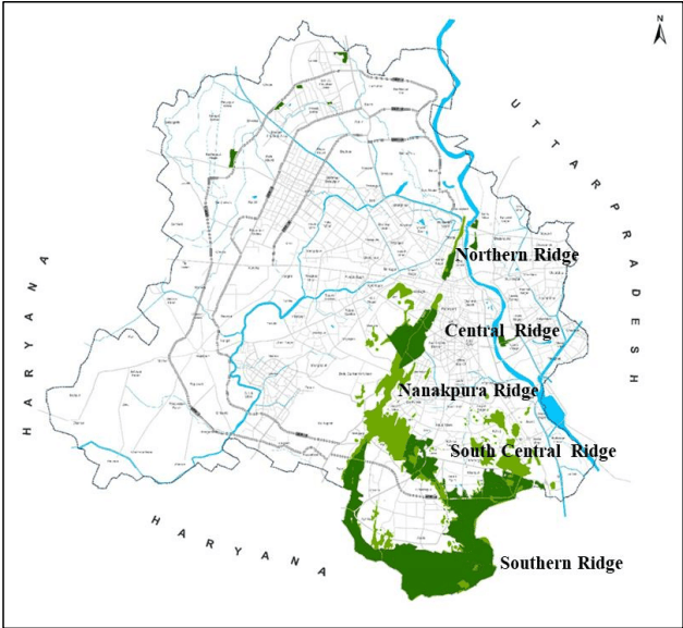
At the same time, the city has made rapid strides in improving the green cover which has significantly increased during the last plan period. Currently, almost 22% of the land area is under green cover as per the Department of Forest, GNCTD. Based on the categorisation of the Indian Forest Act, 1927, Delhi has three kinds of forests. The Ridge is a reserved forest spread over an area of about 7784 Ha (Northern Ridge Forest: 87 Ha, Central Ridge Forest: 864 Ha, South-Central Ridge Forest: 626 Ha, Southern Ridge Forest: 6200 Ha, and Nanakpura Ridge Forest: 7 Ha) that constitutes nearly 6% of NCT of Delhi.
Illustration 1: Ridges in NCT of Delhi (For illustrative purpose only)
The second category is comprised of 26 protected forests, with a total area of about 1658 Ha. Thirdly, 40 unclassified forests are maintained by Department of Forest, GNCTD as ‘City Forests’. Additionally, as per the Delhi Parks and Garden Society, there are more than 18,000 parks and gardens. DDA has also developed seven dedicated biodiversity parks to conserve and protect biodiversity that serve as a model for conservation (refer Annexure 1), and also has been maintaining 746 parks (6830 Ha) in different parts of NCT of Delhi (refer Annexure 1).
(iii) Heritage & Culture:
Delhi is one of the world’s oldest continuously inhabited cities, with a rich cultural and historical legacy reflected in its 1459 identified heritage assets, including World Heritage Sites, protected monuments, heritage buildings, historic precincts and cultural landscapes. Many of these heritage buildings/monuments in Delhi are under severe threat, encroachment, disrepair, incompatible use and insensitive reconstruction/alteration. There is a need for increased emphasis on conservation and monitoring of heritage assets.
The city’s built heritage is largely concentrated in central Delhi in the area between the Yamuna and the Ridge, several of which are clustered in the form of precincts/zones with the potential to become unique cultural hubs for the city. Heritage areas like Walled City
(including Chandni Chowk), Nizamuddin, Mehrauli, Tughlaqabad, Jahanpanah, Hauz Khas and Lutyen’s Delhi contain most important heritage buildings. Many heritage buildings and historic areas are interlinked with natural assets like water bodies and forests, presenting opportunities for integrated planning. A number of activities related to art and cultural festivals, food walks, heritage walks etc. hold enormous potential and should be encouraged to promote tourism and create awareness. Delhi also has landmark buildings of architectural importance which can be brought under the purview of cultural promotion.
Beyond these, Delhi also has diverse public spaces ranging from iconic city level hubs, parks and open spaces like India Gate, Central Park at Connaught Place etc. to large social and cultural facilities, traditional/historic bazaars of the walled city, theme sites like Dilli Haats, markets like Janpath street, Emporia, as well as parks, chowks and streets. Apart from these, various spaces for creative arts such as Mandi House, heritage assets and cultural precincts, environmental assets such as forests, water bodies and the Yamuna floodplains, form the important elements of the city.
(v) Social Infrastructure:
Social infrastructure covers public and semi-public (PSP) facilities including health, education, socio-cultural facilities, safety and security infrastructure, communications, distributive facilities and other related functions. Planning, development and delivery of social infrastructure is done by different service providing agencies.
These facilities are distributed at city, sub-city, community and local level. Urban extensions, as per MPD-2021, such as Narela and Dwarka sub-cities are also being developed with integrated housing, transport, and social amenities.
Delhi is developing key projects to strengthen its position as a global hub for sports, education, business, and international events. The Narela Integrated Sports Complex and Narela Education Hub will serve as major sports and institutional destinations, while Bharat Mandapam and Yashobhoomi (India International Convention and Expo Centre) provide state-of-the-art infrastructure and ICT systems, blending the best of global and local expertise.
Dwarka is being developed as Delhi's international gateway and investment destination, leveraging its strategic location, excellent connectivity through the Metro network, Dwarka Expressway, UER-II and proximity to Indira Gandhi International Airport. The development of the 34-hectare Diplomatic Enclave will strengthen its role as Delhi's international interface, while landmark projects such as Bharat Vandana Park will enhance its tourism, recreation and investment potential. Supported by world-class infrastructure and urban amenities, Dwarka is envisioned as a major hub for business, diplomacy and global engagement.
(iv) Shelter:
Housing has a spatial relationship with employment, social services and other urban activities. Housing and social infrastructure are at the core of defining the quality of life in a city.
The development of land and housing in Delhi has largely been the prerogative of the public sector, with limited private participation. Delhi has assimilated multiple layers of development under Housing. In Residential planned areas, under plotted development there are Co-operative House building Societies (CHBS), DDA housing plots, resettlement colonies and Rehabilitation Colonies (MoR). Similarly, for group housing, General Pool Residential Areas (GPRA) colonies, Employer/Government housing, Co-operative Group Housing Societies (CGHS), DDA Group housing schemes and private group housing projects, have been developed.
Nearly 85% of the city’s population belongs to low and mid-income segments. The high cost of land in the city has resulted in unaffordable housing which has led to proliferation of unauthorised colonies (UCs), slums, and densification of urban villages.
Around 28.4% of the households live in rental accommodation (Census, 2011). 32.3% of the population are migrants (Socio-Economic Survey of Delhi, GNCTD, 2018-19) who prefer rental housing due to low entry and exit costs. Most of this rental housing demand is being catered by unplanned settlements.
In order to improve housing stock and the overall quality of life in unplanned areas, the government has initiated the process of conferment of land ownership rights to the residents of the identified unauthorised colonies and is facilitating the regularization and redevelopment of these colonies in accordance with the applicable regulations of UCs.
The housing demand for Delhi (2011-2047) is estimated to be nearly 40 lakh dwelling units, assuming an average household size of 4.5 persons. The housing demand has been calculated by considering factors such as housing backlog, new demand generated due to increase in population, condition of existing stock (obsolescence) that would need replacement and the vacant housing stock in the city.
(vi) Transportation & Mobility:
(a) Regional connectivity: Delhi is the core of the NCR and has strong regional interdependencies with the adjoining cities such as Gurugram, Noida, Greater Noida, Ghaziabad and Faridabad, which leads to large-scale movement of people and goods in the NCR on a daily basis. A number of new developments in adjoining urban centres and the NCR such as Integrated Freight Complexes (IFCs), International Airport at Jewar, Delhi Mumbai Industrial Corridor (Western), Amritsar Kolkata Industrial Corridor (Eastern), Dedicated Freight Corridors, etc. will also significantly impact the commuter and freight movement patterns, resulting in severe stress on existing transport infrastructure of the city. Urban Extension Road (UER) - II is a strategic
mobility corridor that strengthens connectivity across Delhi integrating the key national highways, airport, three sub-cities, industrial areas and other emerging urban centres. Expansion of the Delhi Metro Rail network, the upcoming High-Speed Rail (HSR) Corridor, Regional Rapid Transit System (RRTS), construction of bypass/peripheral roads, etc. will redefine regional mobility and facilitate decongestion of Delhi.
(b) Intra-city movement: The city also has to address internal challenges for providing access to newly urbanised areas, reducing congestion, revitalising under-utilised transport assets, encouraging walking and cycling, etc. Mobility trends in the future will be characterised by use of clean fuels, implementation of technologically advanced transit systems and artificial intelligence for traffic and parking management and these have to be factored into the transport strategies for the city. The Electric Vehicle Policy of GNCTD is also a step towards promoting sustainable mobility options in Delhi and reducing carbon footprint. Further, Delhi has potential for inland waterways mobility, which needs to be explored.
(c) Public Transport & Active Travel: As per Delhi Integrated Multi-modal Transit System (DIMTS) Ltd. study of 2018, the modal split of trips by motorised modes is about 60:40 in favour of Public Transport (PT) and Intermediate Public Transport (IPT) modes. However, the potential for active travel remains underutilised. In the last decade, the share of walk trips has increased negligibly and cycle trips have reduced by nearly by one-third. Nearly half of the fatal road accidents in Delhi involved vulnerable road users i.e. pedestrians, cyclists, etc. (Source: Road Accidents in Delhi 2019, Accident Research Cell, Delhi Police). Road safety has emerged as one of the important concerns in Delhi and measures to create a safe, walkable and cyclable environment are required.
(d) Parking Management: Efficient parking is another important imperative for Delhi. Parking demand has always been addressed by increasing the parking supply, which led to higher use of private modes for transportation. Allocation of land for parking results in non-optimal utilisation of land resources. Moving forward, a shift towards demand-based parking management strategies and more optimal utilisation of existing infrastructure is essential in Delhi. Parking shall be planned and managed through a unified parking planning framework to promote efficient utilization of parking spaces, improve accessibility, and support sustainable urban mobility.
(a) Physical Infrastructure: Water, sewerage and solid waste management are GNCTD affairs but water supply, power and drainage are inter-state issues. Thus, the need of advance action and arrangement is required for the adequate provision of these infrastructure components. For each component, a broad augmentation plan is essential to meet the future requirement. The concerned agencies namely, DJB, I&FCD, DCB, MCD, NDMC, Department of Environment, GNCTD, DPCC, Department of Power
GNCTD, DTL, IGL and Department of Information & Technology, GNCTD have prepared Infrastructure Plans in consonance with MPD-2047 which are annexed as Service Plans.
i. Water Supply: The water supply and distribution in Delhi are managed by the Delhi Jal Board (DJB). In New Delhi Municipal Council (NDMC) and Delhi Cantonment Board areas, DJB supplies water in bulk while NDMC and Delhi Cantonment manage the distribution. In areas not covered by the distribution system, DJB provides water through tanker service. Delhi is a water scarce city and pressure on available water resources has increased due to population growth, wasteful consumption and systemic loss of water.
For the year 2021, the supply of water was 935 MGD and water demand estimated by DJB was 1380 MGD. By the year 2047, potable water demand estimated by DJB shall be about 1600 MGD.
The Delhi Jal Board (DJB) has projected an additional water requirement of 401 MGD by 2047. To meet this demand, it proposes augmentation of 110 MGD through short to medium-term interventions (over the next 4–5 years) and a further 291 MGD through medium to long-term measures (over the next 10–15 years). These include augmentation of water supplies through substitution of Yamuna water currently used for irrigation, procurement of additional raw water from Uttar Pradesh, and development of upstream storage projects at Renukaji, Lakhwar, and Kishau. Accordingly, achieving the projected water augmentation for Delhi will require coordinated efforts with neighbouring states, particularly Uttar Pradesh, Haryana, and Himachal Pradesh, supported by necessary facilitation and interventions from the Central Government.
ii. Waste Water: DJB is responsible for the sanitation network that includes collection, treatment and reuse/disposal of wastewater. In Delhi, wastewater is managed both by a sewage distribution network system and onsite sanitation system in the form of septic tanks. DJB has also planned decentralised wastewater treatment system and other sludge management systems to avoid dumping of untreated sewage into the drains. In areas where laying sewer lines is not possible, DJB has planned to capture the untreated effluent from the sub-drains through a parallel system of Interceptor Sewer Project, targeting to trap and treat effluent before it lands into the river. DJB is also making efforts to trap the sewage flowing in the major drains directly out falling into River Yamuna by diverting sewage to nearest STPs. Out of the 22 major drains, 11 have already been intercepted to prevent untreated effluent discharge.
At present, Delhi has an installed sewage treatment capacity of 814 MGD against which approx. 744 MGD of waste water is being treated. To further strengthen the treatment capacity, DJB has proposed the construction of new
sewage treatment plants at different locations for treatment of waste water, expected to be around 1285 MGD i.e. 80 % of the supplied water by the year 2047.
Delhi Jal Board (DJB) shall facilitate the supply and use of treated water by the concerned agencies/authorities for landscaping and irrigation of parks, gardens, green areas, and other public open spaces. The use of treated water for such non-potable purposes shall be encouraged to reduce the demand for potable water and promote sustainable water resource management.
iii. Drainage and Storm Water Management: The drainage morphology of Delhi is defined predominantly by the Aravalli foothills and connected outcrops. Storm water movement is largely from the higher elevations in the West towards Yamuna in the East. An Integrated Drain Management Cell has been constituted by GNCTD to prepare a comprehensive action plan for “Alternate Technologies for Management of Waste Water in Drains” in Delhi for remediation and management of all drains of Delhi with representatives of all Drain owning Agencies.
To alleviate the flooding conditions in various parts of the city, storm water drainage infrastructure has to be made efficient along with low-cost floodprevention measures such as water body rejuvenation, using parks for rainwater harvesting, regulating dumping of solid waste in the drains etc. To meet the city’s drainage requirements over the next 30 years, the Delhi Drainage Master Plan is under preparation by GNCTD to address the future demands in the face of rapid urban growth and recurring water logging problems.
iv. Solid Waste Management: The quantum of solid waste generated in Delhi has been rising for the last several years. The management of municipal solid waste (MSW) in Delhi is under the jurisdiction of the Municipal Corporation of Delhi, New Delhi Municipal Council and Delhi Cantonment Board. In Delhi, approximately 47.5% of the municipal solid waste (MSW) generated is processed and the rest is primarily disposed in three landfill sites namely Bhalaswa, Ghazipur and Okhla. Delhi is flattening its legacy landfills and Municipal Corporation of Delhi (MCD) has been executing a large-scale bio mining process to segregate, process, and completely clear these dump sites.
Existing landfill sites have exceeded their capacity and the total quantum of MSW generated in the city is expected to increase substantially, from 13,500 TPD in 2026 to an estimate of 25,764 TPD by 2047.
v. Power: The per-capita power consumption in Delhi is more than 1343 units per annum as against the national average of 1460 units. The conventional power supply capacity in the year 2021 is 7,161 MW. Renewable operational power purchase agreement/tie-up is 923 MW. Peak power demand by 2047 is estimated to be 25,500 MW.
vi. Gas network: Natural gas is widely used in transport sector as Compressed Natural Gas (CNG), in the domestic and commercial sectors as Piped Natural Gas (PNG) and in industries as Regasified Liquefied Natural Gas. The city should shift towards using cleaner fuels such as those based on natural gases in different forms.
vii. Telecommunication and digital infrastructure: Digital infrastructure and services are increasingly emerging as key enablers to Delhi’s growth. Delhi has adopted ‘Right of Way Policy’ in compliance with ‘Indian Telegraph Rules’ to facilitate the provisioning of underground (optical fibre) and over ground (mobile towers) infrastructure for digital infrastructure. In 2020, Delhi had over 57 million telecom connections, out of which 54 million were wireless connections provided by both private and public agencies.
(b) Disaster Preparedness and Resilience:
Delhi has developed in phases since the inception of the Master Plan, with residential, commercial and industrial areas growing over time. As the city continues to expand, many older neighbourhoods need redevelopment and upgradation of physical and social infrastructure to make them safer and more resilient. Regularised and unplanned areas also require improvements in infrastructure, along with better structural, fire and electrical safety.
Delhi is located in Seismic Zone IV and is vulnerable to earthquakes, floods, fires, industrial and chemical accidents, building collapses, water logging and other emergencies. The city has been experiencing floods of various magnitudes due to flooding in the river Yamuna. According to Delhi Fire Service (DFS) statistics, the city had more than 1,45,000 fire incidents during 2016-21, resulting in considerable loss of life and property.
The ‘Delhi Disaster Management Plan’ prepared by the Delhi Disaster Management Authority (DDMA) has identified and listed vulnerable areas in Delhi for various types of disaster. The plan provides recommendations for periodic safety audits for structural safety, fire safety, electric safety, etc.
Over the next two decades, Delhi will develop safe, resilient and sustainable infrastructure to meet the needs of its growing population while strengthening resilience to disasters and climate change. All concerned agencies shall focus to create a sustainable and resource-efficient environment by enabling provision for robust and resilient infrastructure services.
1.7Land Use Plan for NCT of Delhi
1.7.1 Land Use Plan
Land Use Plan means the Plan indicating Use Zones as defined in the Development Code. The boundaries of these Use Zones are defined in the Land Use Plan by features like roads, railway tracks, drains etc. The Land Use Plan for MPD 2047 (Refer Map 1) has been prepared on GIS (Geographical Information System) platform, considering the earlier approved layout plans, Zonal Development Plans, change of land use, existing and proposed spatial policies (like Transit Oriented Development Policy, High-Density Corridor, Low Density Area and Land Pooling Policy) and infrastructure networks like Metro, RRTS, expressways. Further, it ensures continuity of existing/proposed roads and strengthening regional connectivity in the NCR.
The implementation of the Land Use Plan shall be supported through various planning approach of different development mechanisms such as assembly of land, Town Planning Schemes, densification along MRTS etc. These mechanisms shall facilitate planned urban development, redevelopment of the existing built environment, preparation of plans with enhanced infrastructure and services.
The Land Use Plan under MPD-2047 is broadly categorized into the following two planning frameworks:
(i) Planning in Acquired and Developed Areas: In the already existing developed areas, land use has been defined through designated Use Zones under the Development Code. The Plan identifies nine (9) broad land use categories namely Residential, Commercial, Industrial, Recreational, Transportation, Utility, Government, Public & Semi-Public Facilities, and Agriculture & Water Body. These land uses have been further classified into twenty-four (24) Use Zones (refer clause 5.1.3 and 5.1.5).
However, commercial activities in residential plots abutting streets/roads having width 30m ROW and more (in all categories of colonies), which are neither notified as mixed use nor as commercial streets, shall be permitted on ground floor or first lower floor (in case of stilt), subject to payment of charges. All types of commercial activities are permitted on such residential plots except activities involving any kind of obnoxious, hazardous, inflammable, non-compatible and polluting substances or process, only on the ground floor or first lower floor (in case of stilt). Further, in the Policy-led Development Areas, mix of activities/uses permissible shall be allowed within the plots based on Road Right of Way as prescribed in the regulations.
(ii) Policy Led Development Areas: These comprise areas where development shall be through participatory planning mechanisms involving private landowners and other stakeholders (Refer Map 4). Instead of predetermined plot-level land uses, development will be guided by approved spatial policies and planning schemes that promote flexibility, mixed-use development, integrated infrastructure, and sustainable urban growth. The
permissible land uses, development controls, and implementation mechanisms shall be governed by the respective approved Schemes/Projects. These areas include:
(a) Land Pooling Areas: The Land Pooling Areas comprise approximately 200 sq. km distributed across different planning areas. Development in these areas shall be undertaken through an inclusive zoning approach, promoting a balanced mix of residential, commercial, industrial, public and semi-public, recreational, and other compatible uses to create sustainable, self-contained neighbourhoods.
The planning framework adopts a flexible land use regime, wherein the permissible uses and intensity of development shall be determined based on the Right of Way (ROW) of the abutting road. This approach provides flexibility to accommodate evolving economic and social needs, encourages mixed-use development, improves land utilisation, and promotes walkable, transit-supportive urban environments.
(b) Low Density Area: Low Density Area shall comprise of the areas within the depth of one peripheral village revenue boundary along the border of NCTD and LDRA under previous Master Plan, covering an approximate area of 150 sq.km. Development in these areas shall primarily comprise of low-density residential plots, along with activities permitted based on plot size and the width of the abutting road, as per applicable development norms. This approach is intended to enable phased infrastructure provision and orderly development while maintaining the low-density and environmental character of the area.
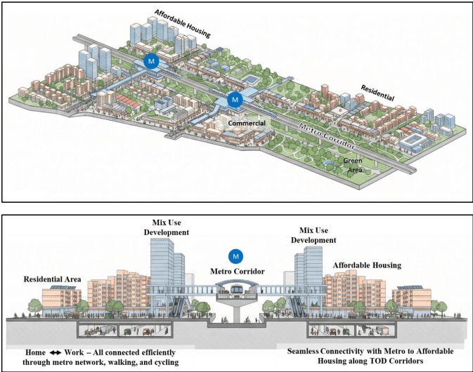
(c) Development under TOD zone: TOD Zones comprise approximately 200 sq. km along Metro corridors and within the influence areas of RRTS, Railway Stations and High-Speed Rail (HSR) stations. These zones shall primarily facilitate affordable housing through compact, transit-oriented, mixed-use development with an appropriate mix of residential, commercial and other compatible uses.
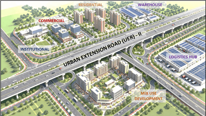
(d) High Density Corridor (HDC) Zone: HDC Zones, covering approximately 20 sq. km along the executed stretch of the Urban Extension Road-II (UER-II), are intended to promote high-density, compact development with mix use integrating residential, warehousing, logistics, commercial, and other compatible uses. The provisions of HDC shall also extend to future stretches of UER as envisaged in the Master Plan, upon their execution. Development shall be regulated through approved projects to facilitate integrated infrastructure, efficient land utilisation, enhanced economic activity, and improved connectivity.
1.7.2 Planning Zones
For the ease of administration, systematic planning, efficient implementation of strategies and overall balanced development of the city, the NCT of Delhi is divided into 17 Planning Zones (Divisions) (refer Map 2) designated 'A' to 'P' (except Zone 'I') in the Master Plan 2047.
Table 1.2Planning Zones (identified under previous Master Plan)
Sl. No.
Zone
Name of Zone
1
A
Old City (Walled City and Other than Walled City)
2
B
City Extension (Karol Bagh)
3
C
Civil Line
4
D
New Delhi
5
E
Trans Yamuna
6
F
South Delhi-I
7
G
West Delhi-I
8
H
North West Delhi-I
9
J
South Delhi-II
10
K-I
West Delhi-II
11
K-II
Dwarka
12
L
West Delhi-III
13
M
North West Delhi-II
14
N
North West Delhi-III
15
O
River Yamuna / Riverfront
16
P-I
Narela
17
P-II
North Delhi
1.7.3 Mapping of Delhi
Delhi, being a rapidly growing metropolitan city, requires a robust planning system capable of handling complex spatial, social, and infrastructural challenges. MPD-2047, which is a long-term perspective framework aims to guide the sustainable and planned development of Delhi over the next two decades. It is critical for the strategies of the Plan to adapt and align with changing needs and ensure that the provisions remain relevant and effective for achieving the vision and goals identified for the development of the city.
To address these needs and ensure precise mapping of land uses, infrastructure and environmental features, MPD–2047 proposes to adopt a Geographic Information System (GIS)- based approach and integrating advanced geospatial technologies for integrating multi-sectoral data and allowing continuous update hereby making planning more responsive.
While the previous Master Plans provided a framework for planned development, the transition from conventional planning methods to a technology-driven spatial planning framework in the MPD-2047 enhances accuracy, transparency, and efficiency in managing Delhi’s complex urban system. The earlier Master Plans relied primarily on conventional 2D maps and manual data integration; MPD–2047 marks a paradigm shift to a dynamic 3D model by leveraging tools such as GIS, real-time data systems, and digital modelling. Preparation of GIS-based Master Plan for Delhi shall also be aligned with the objectives of following national initiatives like:
(i) Atal Mission for Rejuvenation and Urban Transformation (AMRUT), launched by the Government of India to promote the creation of standardized, large-scale geospatial databases for cities to improve urban governance, planning efficiency, and resource allocation.
(ii) PM Gati Shakti National Master Plan, aimed at integrated infrastructure planning focusing on multimodal connectivity which will provide integrated and seamless connectivity for movement of people, goods and services from one mode of transport to another through a GIS-based platform.
(iii) Swachh Bharat Mission has significantly contributed to promoting a cleaner Delhi through technology-based interventions in waste processing and the remediation of legacy dump sites.
The key guidelines include preparation of geo-referenced GIS based maps by developing a layered infrastructure dataset, use of Spatial Decision Support Systems (SDSS), data standardization and interoperability for improving transparency and establishment of updatable digital databases. Adoption of these guidelines will significantly contribute to standardization of spatial data, integration of multi-agency datasets, adoption of digital tools in planning and improved coordination and governance.
1.8Challenges & Key Focus Areas
The experience of the past three Master Plans and baseline analysis of the existing scenario shows that projections regarding various basic infrastructure services have been made with reference to the population growth projections and the increased urbanization requirements. However, the infrastructure provisions especially those related to water, drainage and solid waste management have not matched the pace of development. With a population of over 20 million people in the city now, which is expected to increase to nearly 32 million by 2047, the challenge of transforming the city is immense.
Major challenges which have emerged relate to the unauthorized colonies and slums/jhuggi jhopri settlements. This reality will have to be dealt with not only in its present manifestation, but also in terms of future growth and proliferation.
The MPD-2047 builds on the strategies of the previous plan to bolster development of the city, optimizing land use & density distribution, transit systems and access to services in synergy with the environment and embark on resilient and sustainable growth for Delhi and includes relevant policies to evolve a ‘strategic’ and ‘enabling’ framework that can nurture the future growth of the city.
Some of the key aspects that emerged from the baseline reports, public consultation exercises and analysis of projections for population, resource availability and economic growth have been identified as key focus areas of MPD-2047, detailed in the subsequent paragraphs.
(i) Addressing the gap in housing supply: There is mismatch between housing demand and supply. Unauthorised colonies, slum & jhuggi jhopri clusters and unplanned areas in Delhi fulfill the housing gap by providing lesser expensive options having high densities and poor access to services. Development of different housing typologies and requirement of rental housing needs to be addressed. Delhi is well connected to the NCR region, and regional housing developments will continue to complement Delhi’s shelter needs, given the differences in cost of land. This inter-dependency needs to be factored into the strategies for determining the typologies for housing development in Delhi.
(ii) Mobility: Delhi has one of the largest public transit systems, however, a large number of trips by private vehicles is leading to congestion, unorganised parking, air pollution, etc. To encourage modal shift to public transit systems, last mile connectivity infrastructure for walking and cycling is required. Delhi’s active travel potential needs to be leveraged to encourage walking and cycling as an affordable, comfortable, safe mobility option that accrues health and environmental benefits, optimizing parking requirements and facilitating better parking management.
(iii) Environment: Delhi is rich in terms of Green assets with high level of overall per capita greens, forests, ridge and parks. However, as these are inequitably distributed spatially and thus need to be enhanced further to have a spatial equitable distribution which shall also help in mitigating climate change impacts such as regulating rainfall patterns, reducing urban heat and flooding etc. Issues such as air, water and noise pollution need to be addressed comprehensively at regional as well as local level to foster sustainable urban development and to conserve resources. A dense network of drains, water bodies and perennial river Yamuna flows through the city but the water pollution in the river and other water bodies has resulted in disappearance of aquatic life and disturbed water ecology. Revival of the river, drains and combating the alarming levels of air and water pollution are urgent challenges that need to be addressed. These strategies also have to consider the protection and restoration of floodplains, as encroachment or polluting activity in the flood plains increases the ecological damage and the potential flood hazards.
(iv) Economic potential: Delhi’s economic potential can be realised through interventions such as promotion of clean industries, economy hubs, shared work spaces for start-ups. Sectors such as health, higher education, tourism and MICE, modern logistics and trade are to be promoted. There is a need to improve the quality of existing workspaces and creating new opportunities for the informal sector as well.
(v) Connecting public with open spaces: The mismatch in population growth and development has resulted in inadequate open spaces and facilities. Strategic regeneration initiatives can rejuvenate older areas of the city and optimise utilization of land. Further, public spaces have to be made universally accessible and safer.
(vi) Conserving heritage assets: Delhi is a cultural hub with both tangible and intangible heritage assets. Preservation of assets and their adaptive reuse is required for preventing degradation and loss of heritage and historic fabric. There is a need to formulate strategies to utilise this strong cultural capital for boosting economy and fostering unique cultural and public spaces and acknowledge the landmark buildings as modern and industrial heritage of the city and bring them under the purview of conservation and cultural promotion.
(vii) Water: Despite abundance of water resources in the city, Delhi is a water scarce city. The city is also facing issues of reduced groundwater levels, pollution in river Yamuna and frequent instances of waterlogging. Management of water resources and adoption of conservation and reuse strategy is critical to the growth prospects of Delhi. To alleviate the flooding conditions in various parts of the city, storm water drainage infrastructure has to be made efficient.
(viii) Power and Waste Management: Delhi’s power consumption and waste generation is one of the highest in the country. Existing efforts towards recycling of waste and shift to renewable energy have to be mainstreamed. Delhi’s infrastructure should conform to the rapid nature of technological growth, there has to be space to accommodate new and emerging technologies like thrust towards non-fossil fuel-based sources, energy-efficient fixtures, circular economy, optimizing waste as a resource etc.
(ix) Disaster preparedness and resilience: Delhi is under high risk from earthquakes, incidents of fire and flooding. High built densities, poor quality and age of built stock further increases the vulnerability to disasters. COVID-19 pandemic brought into focus the need to create self-contained areas having mix of uses and resilient infrastructure. Strategies aligning with the state and national regulations on disaster mitigation and preparedness needs to be taken into account to reduce the vulnerability and enhance resilience to natural disasters.
(x) Monitoring and evaluation: A common database should be established at city level with an integrated monitoring protocol and multi-agency coordination. It is imperative to periodically monitor progress of the city with respect to different sectors to enable course correction in the Plan as it is adapted to changing needs and priorities.
PART II: VISION, STRATEGIES, SPATIAL POLICIES & DEVELOPMENT FRAMEWORK
CHAPTER 2. VISION AND OBJECTIVES
2.1Vision 2047
(i) The vision for Master Plan 2047 is to “Foster a Sustainable, Liveable and Vibrant Delhi”.
(ii) The following Goals will be pursued over the Plan period for overall happiness & wellbeing of its inhabitants:
(a) Goal 1 (G1): Become an environmentally sustainable city that provides a healthy environment for its citizens, is resilient to impacts of climate change and disasters.
(b) Goal 2 (G2): Develop as future-ready city that offers good quality, affordable and safe living environment with efficient services and green mobility systems.
(c) Goal 3 (G3): Emerge as a dynamic place for economic, creative and cultural development.
(iii) The Plan also acknowledges diversity and works towards creating an inclusive city to facilitate accessibility and opportunity for people.
2.3Key directions
(i) Differential Development Strategy: The Plan adopts flexible Development Control Norms with differential distribution of Floor Area Ratio (FAR) based on factors such as environmental sensitivity, access to mass transit, infrastructure capacity, and the strategic role in different areas of the city. This approach promotes efficient land utilisation, supports sustainable and compact urban development, and enables areas to evolve as vibrant hubs for living, working, recreation, and public life.
(ii) Strategic approach and mixed use development: The Plan directs future growth towards strategic growth centres and corridors supported by high-capacity public transport and infrastructure. Development incentives, including higher FAR and Transferable Development Rights (TDR), are provided to channel investments into these areas, optimise infrastructure utilisation, and reduce development pressure on environmentally sensitive and infrastructure-deficient areas. The Plan also promotes a transition from conventional single-use zoning to mixed-use development, allowing compatible residential, commercial, institutional, and other uses to coexist. This approach creates vibrant, walkable, and inclusive neighbourhoods, reduces travel demand, and enhances economic activity and public life.
(iii) Institutional Governance: The Plan recognizes the multi-level governance structure in NCT Delhi and provides a coordinated institutional framework to guide government-led development and redevelopment initiatives. It promotes collaboration among key institutions, including the Delhi Development Authority (DDA), Government of the National Capital Territory of Delhi, Municipal Corporations, and various Central and other government agencies responsible for land, infrastructure, housing, transport, heritage, and public services. This approach will support strategic planning, coordinated implementation, and integrated redevelopment of key urban areas while addressing national importance, local needs, sustainability, and inclusive growth.
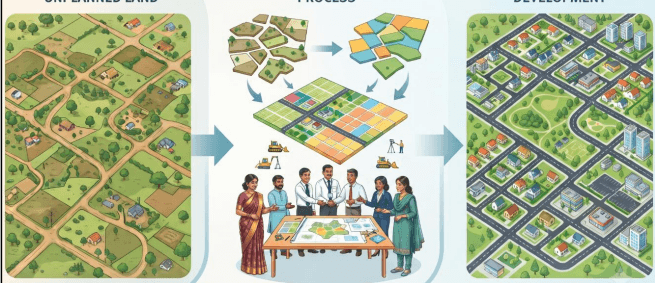
(iv) Private sector participation in development: The Plan promotes development by the private sector through joint action of various stakeholders (land pooling, amalgamation, planning and execution). This is a significant paradigm shift where development of greenfield areas and regeneration of brownfield areas shall be implemented through private initiative.
(v) Outcome based plan monitoring: The Plan provides a robust monitoring framework to track larger city-level objectives through 20 suggestive key performance indicators. This shifts the focus of monitoring from creation of assets to assessment of impacts; e.g. instead of monitoring the number of STPs installed, the Plan will assess the status of pollution in water bodies. This will also enable periodic course correction to realign strategies and actions.
(vi) Special Provisions for Local Area Planning: To address emerging development needs and unlock the potential of identified areas, provisions may be made for rental accommodation for youth and the workforce engaged in the service and other emerging sectors; tourism and hospitality infrastructure, including hotels, food and beverage establishments, cloud kitchens, and other economic activities; high street shopping; public realm improvements; façade control; universal accessibility for Divyangjan; and safety infrastructure to enhance the participation of women and children in the city through Special Local Area Plans (SLAPs). Such plans may be prepared by the concerned agencies, following due stakeholder and public consultations, with the approval of the Central Government, to further promote and achieve the objectives of MPD-2047.
CHAPTER 3. STRATEGIES
2.2Objectives for 2047
In order to realise the Vision and Goals effectively, following 6 objectives are formulated and described in detail as strategies in the Master Plan:
(i) Objective 1: Prioritising Environmental Sustainability– To prioritise environmental concerns focusing on rejuvenation of natural assets and biodiversity, reducing pollution, greening of built environment, developing planned recreational facilities, supporting circular and green economies, and creating a diverse portfolio of natural and planned open spaces.
(ii) Objective 2: Facilitating Economic Development– To promote clean economies, facilitate a unique economic role for Delhi while ensuring symbiotic linkages within NCR, improve the overall investment climate and support a variety of work and workspaces.
(iii) Objective 3: Enhancing Heritage, Culture and Public Spaces– To protect and enhance heritage and cultural fabric, facilitate creation of a vibrant and inclusive public realm, build strong economic linkages and create opportunities for cultural experience, tourism and active public life.
(iv) Objective 4: Improving Housing and Social Infrastructure– To meet the housing demand for different income groups and typologies, promote regeneration of old built fabric, and fulfil demand for social infrastructure in dense areas of the city and creating new housing stock through spatial policies in greenfield areas.
(v) Objective 5: Moving Towards Efficient and Low-Carbon Mobility– To encourage modal shift in favour of public and IPT modes of transport. To provide affordable and efficient
mobility options, homes and jobs closer to mass transit and facilitate seamless inter-modal integration.
(vi) Objective 6: Developing Resilient Physical Infrastructure– To encourage development of resilient physical infrastructure, promote sustainable use of resources like water and energy, facilitate efficient services, focus on provision of digital infrastructure, and build the city resilient to shocks and disasters.
3.1Environment
3.1.1 Addressing Pollution and Climate Change
Delhi needs to address internal sources of pollution and its impact on public health and climate change. The Plan takes cognisance of Delhi’s State Action Plan for Climate Change and provides complementary strategies for improving green cover, promoting clean industries, low-carbon technologies, green mobility, green buildings, etc., for improvement in environmental parameters. Relevant laws/regulations are in existence for environment protection in Delhi. A multi-sectoral approach has been provided to facilitate following:
(a) Reducing air, water and noise pollution from local sources.
(b) Improving ability to cope with impacts of climate-related issues.
(i) Strategies: Strategies shall be adopted by concerned agencies for ensuring enforcement of regulations, addressing pollution, enhancing Delhi’s green-blue assets in terms of quantity, quality and accessibility, thereby, creating an environment for protecting and nurturing the rich and diverse ecological heritage.
(a) Improving green-blue assets: Development of green and blue assets can mitigate air, noise, water and soil pollution, and will help in addressing climate change impacts, urban heat island effect and flooding etc. Comprehensive strategies and actions towards improving Delhi’s green-blue infrastructure are detailed out in the Plan.
(b) Promoting clean economic activities:
i. Prohibitive/Negative industries as per list given in Annexure 7, shall not be permitted to operate within Delhi.
ii. Concerned agencies shall ensure that existing polluting industries are shifted or replaced with other permitted activities. Non-polluting economic activities shall be encouraged.
(c) Minimising vehicular pollution: Vehicular pollution is recognised as a significant contributor to both air and noise pollution in the city. To mitigate this, strategies shall be made to promote the use of public transport, electric vehicles, and non-motorized transport (NMT), while encouraging active travel modes which shall subsequently reduce reliance on private vehicles and the total number of vehicular trips.
(d) Addressing Water Pollution: Pollution of surface water bodies and ground water shall be addressed as follows:
i. Steps to be taken by concerned agencies to improve water quality of the River Yamuna and drains, lakes, wetlands, and baolis, including the removal of existing pollutants in a time-bound manner.
ii. Decentralised treatment and reuse of wastewater as an integral part of various development schemes to be included by concerned stakeholders.
iii. Adequate flow and self-cleansing velocity shall be maintained in the River Yamuna and associated water bodies to enhance natural purification and prevent pollutant accumulation.
(e) Preventing pollution due to unregulated disposal of solid waste: Unregulated dumping and disposal of solid waste pollutes soil and water. This shall be regulated through the following strategies:
i. Dumping of solid waste in areas other than designated waste management/disposal sites, shall be strictly prohibited and violations shall be penalised by the concerned local body.
ii. Segregation of waste at source, reuse and recycling, as well as other innovative mechanisms for post-processing of solid waste, shall be adopted by local bodies to ensure minimum requirement of landfills. These requirements to be included as part of various development schemes by local bodies.
(f) Dust Management: Dust is one of the major contributors towards PM10 and PM2.5 concentrations in the city. The following major strategies shall be adopted for dust management:
i. All construction projects shall follow dust mitigation measures in handling construction materials and C&D waste as per guidelines issued by Central Pollution Control Board (CPCB) from time to time.
ii. Soft landscaping or grassing of vacant and scrub lands, incidental areas along roads including central verge/berms, buffers and other network infrastructure shall be taken up by concerned agencies in a time bound manner, as per feasibility.
iii. Footpaths shall be fully paved (except tree pits and grates) with durable and permeable tiles/materials.
(g) Reducing Noise Pollution: Action Plan for Noise Pollution shall be prepared and implemented by GNCTD or any other guidelines recommended by government from time to time. The following measures may be adopted:
i. Green buffer through trees, land formations, mounds, embankments, etc. along major roads to provide effective barriers against transmission of noise.
ii. The design and surface materials of roads and pavements to ensure reduction of noise.
iii. Environmentally stressed zones in Delhi may be identified, and local area environment management plans to be prepared for such areas, together with regular monitoring.
(h) Other mitigation measures for identified hotspots of pollution, flooding and heating:
i. Pavements, roads and roofs may preferably be constructed using innovative materials and coated with light colours, wherever possible.
ii. Road sections shall include appropriate trees and buffers to reduce air and noise pollution. Sustainable urban drainage components such as bio-swales, rain gardens, etc., shall be incorporated to mitigate water logging, wherever feasible.
iii. Indigenous species of trees and plants which act as pollution filters shall be included in various greening initiatives and development of Parks. Global best practices and other technological solutions maybe explored for mitigating pollution by concerned agencies.
(ii) Monitoring framework: A monitoring framework for tracking environmental parameters shall be set up by Delhi Pollution Control Committee (DPCC). Data collected from such monitoring stations shall be regularly published through online platforms to improve awareness about these issues. Crowdsourcing of information may be explored for parameters like air pollution, noise levels, reporting on illegal dumping of solid and liquid waste into greens, water bodies, etc.
3.1.2Green-Blue Infrastructure
Delhi is well endowed with blue assets. The most significant among these is the River Yamuna that has a historic, cultural, and spiritual connect with the city. The city has an extensive network of natural and constructed drains, largely spread across three drainage basins of Najafgarh, Trans-Yamuna and Barapullah. However, the area under blue assets have been threatened over the past decade due to encroachment, pollution and natural drying up of water bodies. The Master Plan provides a framework for integrated management of ‘Green-Blue Infrastructure’ in the city envisaging an increase in:
(a) Area under natural green-blue assets
(b) Planned green spaces
A three-pronged approach shall be implemented over the Plan period to preserve and enhance existing natural assets, create new assets and increase the green-blue features within the built environment. This approach will provide the following benefits:
i. Environmental: enhanced greens, richer biodiversity, reduced temperature, flooding and pollution and improved resilience to climate change.
ii. Health: clean living environments, promotion of active lifestyle, and improved quality of life.
iii. Socio-cultural: environmental awareness and connection of people with nature, availability of spaces for leisure and social activity.
iv. Economic: improved attractiveness as an investment destination and boost to green economies like urban farming, etc.
(i) Preservation and improvement of natural green and blue assets: Many of the natural assets (refer Annexure 3) in the city, such as the river, ridge, drains and water bodies are already notified as ‘protected’ or ‘reserved’ areas by concerned agencies.
(a) Comprehensive strategies shall be implemented for preserving and enhancing natural green and blue assets as follows:
i. Boundary protection:
a. Fences, earth-berming with vegetation, pedestrian/cycle paths along the boundary, or any other suitable method shall be adopted for protection of natural assets.
b. The assets where the boundaries are clearly demarcated by roads, bunds or natural features, construction of fences/walls shall be avoided, as far as possible to maintain visual integration and allowing surface water run-off.
ii. Other strategies:
a. Invasive and alien species that cause land degradation or disturb ecology to be replaced with indigenous flora that require less water and/or are effective for pollution control.
b. Afforestation with indigenous species and tree transplantation may be taken up in identified areas as per feasibility.
c. Environmental assets shall be monitored regularly and necessary steps shall be taken by concerned agencies to keep these assets free from pollution and address any other issues.
d. Enhancing biodiversity for conserving and preserving the ecosystems of the River Yamuna and the Aravalli Ridge. Suitable aquatic species may be introduced to restore health of water bodies.
e. DJB, I&FC and other concerned agencies shall implement rejuvenation of the river and lakes in the city. Treated wastewater shall also be made available for lake/water body rejuvenation projects.
(b) Enhancing people’s connection with nature: Environmentally Sensitive Areas to be identified as ‘interactive zones’, where regulated public access shall be considered for activities such as active/passive recreation, exercise/yoga, nature classes, environmental research, picnics, camping, biodiversity tours, etc. by concerned agencies, taking into consideration universal access of such facilities. Amenities like
toilets, drinking water, resting places, visitor information centres, kiosks etc., may be provided as per norms.
(c) Special initiatives for the rejuvenation of River Yamuna and its floodplains: Delhi is a river city and its history and cultural ethos is closely linked with the River Yamuna and its floodplains. The following strategies have been adopted for rejuvenation of the river and floodplains:
i. River Yamuna and its floodplains shall be identified based on the prevailing records and technical assessment of Irrigation & Flood Control Department, GNCTD and other Competent Authority as applicable.
ii. Active floodplain shall be a ‘no construction zone’ and only recreational uses shall be permitted. All unauthorised construction including religious structures shall be demolished by the concerned agency on priority. Essential government utilities, socio-cultural and recreational activities, public infrastructure development; promoting conservation of floodplains shall be permitted only with approval/NOC of the competent authority/statutory body.
iii. Area outside Active flood plain shall have restricted development. Existing authorised and planned constructions as well as essential government utilities shall be allowed to continue as per permissible norms and approval/NOC from statutory body. Further developments in the zone shall be restricted to socio-cultural and recreational uses, essential utilities and public infrastructure with approval/NOC of the competent authority/statutory body.
iv. Measures for rejuvenation of the River Yamuna and its floodplains:
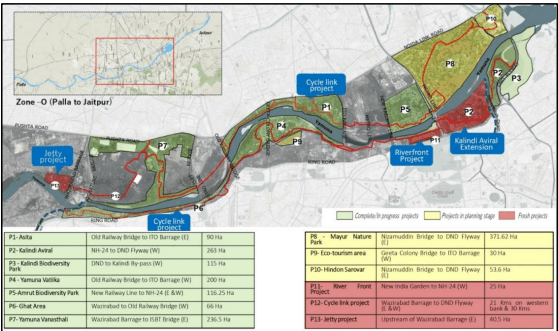
a. Rejuvenation and Ecological restoration of the River Yamuna along the 22 km stretch between Wazirabad Barrage and Okhla Barrage
b. Implementation of 13 major restoration projects for the rejuvenation of approximately 1,700 hectares of the Yamuna floodplain, focusing on restoring wetlands, natural depressions, floodplain ecosystems, and biodiversity while enhancing climate resilience and groundwater recharge.
c. Ecosystem restoration shall be carried out by de-silting of existing wetlands and restoring them for catchment of floodwaters and creating new wetlands by developing and deepening the existing depressions into storage basins. These would complement floodplain forest and grasslands that have been planted with species of riverine nature as both would serve as habitats for bio-diversity.
d. Green buffer shall be maintained along the edge of the river, wherever possible, and planted with species of riverine nature to protect the river edge.
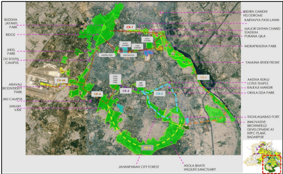
e. Development of Ridge–Yamuna Park Connector as an integrated 200 km cycling network, including a 52 km stretch along the Yamuna floodplain, to
promote connectivity and strengthen the Ridge–Yamuna continuum. A 75–100 m wide public greenway may be developed along the embankments, wherever feasible, with cycling and walking trails and spaces for passive activities to enhance public access to parks and the river and encourage a stronger river– people connect.
Illustration 2: River Yamuna floodplain Projects (For illustrative purpose only)
Illustration 3: Park Connectors (For illustrative purpose only)
f. Improve the water quality of the River Yamuna by intercepting and treating all 22 drains discharging into the river through sewage treatment, constructed wetlands, and bio-remediation. The intercepted drain corridors shall be restored
and seamlessly integrated with the green spaces and floodplains to create continuous ecological corridors. Discharge of untreated or unregulated sewage, wastewater, industrial effluents, and solid waste into the river and other water bodies shall be strictly prohibited.
g. Areas such as Ghats etc., shall be utilised for socio-cultural activities in a sustainable manner and activities such as disposal of pooja material, immersion of idols etc. during festivals shall be regulated.
h. Manual security and CCTV surveillance shall be deployed and installed to check the dumping of malba, garbage or any other such illegal activities and construction in the floodplains.
(d) Preservation of eco-cultural assets: Delhi has a number of historical monuments located within or in close proximity to green and blue assets. Archaeological Parks are an example of such eco-cultural assets. Cultural Resource Management Plans (CRMPs) shall be prepared to preserve and develop such eco-cultural assets. Historical gardens, water structures (baolis, wells, tanks) etc., shall be taken up for rejuvenation by concerned agencies. Delhi's historic baolis shall be taken up for restoration and integrated into the city's groundwater recharge strategy by reviving their traditional water-harvesting functions, wherever feasible. Efforts shall be made to re-establish lost connections with water systems and aquifers, wherever feasible, to enhance ecological sustainability and water security.
(e) Protection of trees, improvement of recreational areas:
i. Development of Delhi as one of the greenest metropolitan of India with afforestation, multi-tier vegetation buffers, expanding city forests, conserving Aravalli ridge and reconstructing natural ecosystems and promoting large-scale afforestation.
ii. Enhancing tree cover through tree-layer densification and conserving the Ridge, restoring native forests, and replacing invasive species with indigenous trees, thereby, creating a cleaner, cooler, greener, and more climate-resilient capital for every citizen.
iii. Concerned agencies shall identify and protect unique tree corridors, heritage trees, trees with high carbon sequestration rates for mitigating noise and air pollution, etc. Planting of indigenous trees and integration with cultural trails/nature trails, etc. shall be promoted. In order to preserve the existing tree cover, all projects shall follow the Tree Transplantation Policy of the GNCTD, as amended from time to time.
iv. The development of micro forests in urban areas using dense native plantation methods to enhance biodiversity, improve air quality, and increase urban green cover shall be taken up by the concerned land owning agencies.
(f) Other Measures: The following strategies shall apply to projects adjacent to environmentally sensitive areas:
i. Greenfield projects located along natural drains and water bodies shall maintain a minimum mandatory buffer from the edge of the drain/water body. Such buffers shall be maintained by the respective landowners/DEs as active green areas with gardens, plantations, trees, landscaping, etc. No construction or parking shall be permitted in these buffers.
ii. Dumping of construction waste or outfall of sewage/wastewater from surrounding development shall be strictly prohibited in these areas and their buffers.
iii. Buildings may be oriented to face the green and blue assets and maintain active facades in the form of balconies, windows, pedestrian entries, commercial or public frontages at the ground level, etc.
iv. Environmental Impact Assessment (EIA) shall be mandatory as per prescribed guidelines.
(ii) Development of new Green-Blue Assets:
(a) Low density development on the city periphery: In order to safeguard environmental sustainability along the city periphery, restricted development shall be permitted in the Low Density Area.
(b) Green buffers along drains as city-level Greenways:
i. The I&FC and other concerned agencies shall take up development of greenways for creating a city-wide network of green-blue assets connected through pedestrian and cycling paths developed along the drains.
ii. The buffers may be maintained as natural or landscaped green spaces or developed as wetlands and marshes for bio-swales to capture storm water to encourage groundwater recharge. Sections of buffers may be designed for active public use in the form of parks, spaces for yoga, active sports, open-air exhibitions, performances, arboretums, community gardens, boating, kiosks, etc. Heritage trails may be integrated with the Greenways.
(c) Repurposing under-utilised sites and wastelands as green-blue assets:
i. Non-functional thermal power stations, such as Rajghat Thermal Power Station, Badarpur Thermal Power Station, defunct government amenities and other degraded or underutilised sites shall be identified by the concerned agencies for repurposing and adaptive reuse for socio-cultural, institutional, ecological, recreational, or other public uses.
ii. Circular economy strategies like processing/recycling of legacy wastes at landfills.
(d) Other initiatives:
i. Provision of planned greens in land pooling areas: Existing plantations, wetlands, low-lying areas shall preferably be developed as public parks and aquifer recharge ponds in order to retain the drainage pattern and protect these assets. Mixing of uses shall be permitted within buildings to augment areas under parks and open spaces.
ii. To prevent flooding, watershed management shall be done by the concerned agencies.
iii. Provision of active recreation and sports facilities:
a. New sports facilities/infrastructure such as stadiums, district sports complexes, playgrounds, multi-purpose grounds etc. shall be created to encourage healthy living and active lifestyle as well as provide infrastructure to enhance sports skills.
b. Podiums and terraces can be utilised for provision of open-air sports facilities subject to safety clearances.
c. The sports facilities within group housing and schools, shall be allowed as prescribed.
iv. Special greening projects: All concerned agencies are encouraged to develop projects such as biodiversity parks, amusement parks, children’s adventure grounds, nurseries, micro forest, urban forests, green roofs and terraces, community gardens, pollinator gardens, urban wetlands etc.
v. Ground water recharge: DDA/DJB and other concerned agencies shall undertake projects to facilitate groundwater recharge by creating artificial water bodies.
vi. All-abilities play areas: These may be created by earmarking land or retrofitting of existing community and district parks by demarcating specific areas. These areas have to be designed for play and recreational activities catering to children of all groups and people with special needs or disability and the elderly.
(e) Lands surrendered by polluting industries that were directed to relocate/shift outside Delhi to be utilised for developing greens and open spaces.
(f) Concerned agency shall undertake restoration of the drains in Delhi. The Sahibi river (Najafgarh drain) may be developed into an eco-tourism hub with a navigable waterway, as per feasibility.
(iii) Enhancing Green-Blue features in the built environment: The following interventions may be adopted by concerned agencies and/or Resident’s Welfare Associations (RWAs) / Market Trader’s Associations (MTAs) etc., to enhance green-blue features in planned greens, public spaces and built structures:
(a) Greening of public areas:
i. Local bodies may undertake greening of streets having ROW 18m and above. Such streets may be developed by creating avenue plantation of appropriate shade-giving trees, plazas, bio-swales along drains etc., to create a comfortable microclimate. Bridges and Foot-Over-Bridges may also incorporate green elements on pillars, roofs, parapets etc. Greening/landscaping shall be taken up on a priority basis in streets where Walk Plans are being implemented.
ii. The surface parking sites shall preferably provide mix of pervious and non-pervious paving. Trees shall also be planted at regular intervals in such sites, wherever feasible to facilitate percolation of water.
iii. Respective agencies shall take up landscaping and plantation in residual spaces under flyovers, land along water pipelines, unpaved road sections etc. Rainwater harvesting features shall be incorporated in flyovers and elevated MRTS/RRTS corridors. Plantation shall be permitted as per norms on footpath.
(iv) Management of Green-Blue infrastructure:
(a) A database of Green-Blue Infrastructure shall be developed.
(b) For protection and enhancement of green-blue assets, there shall be zero tolerance for unauthorised construction or encroachment in ‘Environmentally Sensitive Areas (Annexure 3). Any encroachment on Government land shall be strictly acted upon and not be compensated or rehabilitated.
(c) Concerned agencies may explore innovative funding mechanisms for greening initiatives.
(d) Concerned agencies shall engage local stakeholder groups for protection and improvement of green-blue assets, and develop sense of community ownership towards these shared resources.
(b) Water Sensitive Urban Design:
i. Storm water drainage shall be integrated in the landscaping and design of parks and along the roads. Creation of rainwater harvesting sumps may be encouraged in the parks.
ii. Impervious paved surfaces shall be replaced with semi-pervious paving material allowing groundwater recharge.
iii. In parks (community level and above), decentralised wastewater treatment facilities may be integrated into the landscape design and the treated water may be used for horticultural purposes or recharging of ground water. Dedicated space may also be provided for processing of the organic/horticulture waste.
(c) Encouraging horticulture/food production: Activities such as urban farming, community gardens, vegetable gardens, green walls, vertical gardens, rooftop gardens, terrace garden/farming, hydroponics, aquaponics, container gardening, herb gardens, etc. shall be encouraged through following strategies:
i. Grass and shrub cover shall be encouraged as a dust reduction measure on vacant lands. The vacant plots shall also be permitted to undertake urban farming/gardening as an interim activity.
ii. Vertical farming (indoor farming) shall be a permitted activity subject to structural safety.
iii. Local bodies and concerned agencies may provide guidelines and capacity building support to communities/RWAs/schools/other stakeholders for undertaking above activities.
(d) Sustainable features for buildings and sites:
i. Provisions of green features in buildings shall be as per UBBL.
ii. Development of green-blue features within plots/buildings in the form of roof gardens, terrace gardens, green walls, landscaped and/or pervious ground, etc. shall be encouraged.
iii. Local bodies/GNCTD may grant appropriate tax incentives for encouraging implementation and maintenance of greening elements such as green roofs, vertical greens, etc. in existing buildings and in plot-level reconstructions.
3.2Economy
Delhi has a service led economy dominated by trade, retail, and public administration with limited manufacturing due to land and environmental constraints. This plan aims to enhance Delhi’s economic potential by creating employment opportunities and supporting the development of diverse workspaces to meet evolving needs. It aims to promote the growth of the formal economy, making provisions for the informal sector and encourages the development of non-polluting industries.
Strategies of the Plan will facilitate the following:
(i) Development of economic hubs– relating to medical tourism and wellness, media and entertainment industry, cyber/IT hub, education etc.
(ii) Redevelopment of Planned commercial centres, unplanned industrial and godown activities in non-conforming areas.
(iii) Optimised utilisation of existing economic centres including 24x7 economy.
(iv) Improvement of facilities for the informal sector.
3.2.1Development strategies
(i) Promoting clean economy: The Plan aims to promote growth of non-polluting industry, retail trade, wholesale and warehousing, logistics, government offices, banking and finance. Following are the key focus sectors for Delhi:
(a) Knowledge and cyber economy: Cyber and digital economy, high-tech robotics and electronics, knowledge and innovation, research and development, etc.
(b) MICE (Meetings, Incentives, Conferences and Exhibitions), cultural and creative economy: World class centres for MICE, hospitality, tourism, design and fashion, publishing, F&B, media, visual/performing arts, entertainment industry, etc.
(c) Health and education: Schools and higher education, tertiary/specialty healthcare, wellness, research and development, bio-tech, pharmaceutical research, etc.
(d) Logistics & commerce: E-commerce, logistics, warehousing, big box retail, etc.
(e) Circular economy: Recycling and repair economy, waste water reuse, recycling and upcycling of solid waste including waste, e-waste, plastic waste, etc.
(ii) Developing/Revitalising strategic economic hubs and centres: Provisions have been made for planned mix of uses which shall include social facilities, hospitality/hostels/rental housing, worker’s housing. These centres shall be further reinforced with improved public transport access, pedestrian connectivity and public spaces in economic hubs and centres.
(a) Economic Hubs: Identified areas shall be developed as economic hubs for attracting investments and improving availability of work spaces. Areas around identified transit stations shall be developed as high-intensity mix-use nodes, facilitating location of residences and work-spaces closer to public transport and better accessibility to various socio-cultural facilities/activities in Delhi.
(b) Upgradation of existing economic centres: Existing economic centres (i.e. MCC, DC, CC) shall be upgraded through regeneration which will improve transit access, public space, quality of physical and digital infrastructure.
(iii) Promoting green economy: The plan promotes urban farming, community gardens, vertical gardens, rooftop gardens, terrace garden/farming, hydroponics, aquaponics, etc. at building and plot level.
(iv) Facilitating decentralised workspaces and emerging forms of employment: Decentralised workspaces in the form of warehouses for e-commerce, co-working spaces for start-up economy, provision for cloud-kitchen and other emerging forms of employment shall be facilitated and promoted through improvements in walkability, availability of public amenities, etc.
(v) Fostering 24 x 7 Economy: The concept of ‘24-hour city’ shall be promoted by identifying nodes, precincts or circuits to attract tourists and locals. Extending the duration of utilisation of work spaces, socio-cultural and commercial facilities will promote a vibrant night life and boost local economy.
(vi) Supporting Informal sector and Female Workforce: The Plan includes provisions for accommodating informal units within planned use premises/layouts. In addition, provisions for street vendors shall be in line with the Street Vendors (Protection of Livelihood and Regulation of Street Vending) Act, 2014 and other relevant regulations issued from time to time. Provisions of childcare facilities, public conveniences etc. in work centres shall be made for female workforce.
(vii) To curb the concerns regarding pollution, shift towards cleaner economies such as IT/ITES, knowledge-based and hi-tech industries, entrepreneurial activities, assembly-based industries, tourism, hospitality, communication, tertiary healthcare and higher education is envisaged.
3.2.2Trade and Commerce
(i) Pre-1962 Commercial Areas: Residential areas and streets/stretches declared as commercial areas/streets prior to the notification of MPD-1962 or where commercial use was allowed in MPD-1962 shall continue such use to the extent permissible in MPD-1962 subject to documentary evidence. Local bodies may permit commercial activities existing prior to 1962 in residential areas subject to documentary evidence.
(ii) Metropolitan City Centre (MCC): The following areas collectively serve as Delhi’s central business district and are referred to as the MCC:
(a) Connaught Place and extension includes Connaught Place (CP) and identified length of radial roads emerging from the outer circle i.e. Janpath, Sansad Marg, Baba Kharak Singh Marg, Panchkuian Road, Barakhamba Road and Kasturba Gandhi Marg, besides Gole Market, Mandi House, Pragati Maidan and Indraprastha Estate.
i. Connaught Place (CP) & extension are iconic hubs characterised by heritage and landmark buildings and mix of office, hospitality, entertainment, retail and business activities. Size of plots as per existing layout plan shall be maintained and no subdivision shall be permissible.
ii. Mandi House is a cultural hub with socio-cultural facilities, educational institutions, government offices, state bhawans, etc. The existing character of the area shall be maintained and enhanced.
iii. Pragati Maidan has international significance and serves as a global MICE hub. It has been redeveloped as Bharat Mandapam, a state-of-the-art international exhibition-cum-convention centre.
iv. Indraprastha Estate is predominantly a hub of government offices interspersed with institutions, historical monuments, and sports and cultural complexes. The area shall be promoted as an Institutional Hub.
(b) Walled City and extensions is the traditional area which is the economic centre not only for Delhi but for the country.
Walled City is a Heritage Zone with concentration of heritage buildings its precincts like Chandni Chowk. Improvement/regeneration plan shall be prepared for shifting of godown/warehouses activity outside walled city and promotion of retail and cultural activities in the area.
Areas outside the Walled City include Paharganj, Sadar Bazaar, Azad Market, Bara Hindu Rao, etc. Specific economic activities such as hospitality district at Paharganj, warehousing and wholesale activity at Sadar Bazaar, etc. shall be revitalised through regeneration. Any traditional bazaars or other areas of cultural/economic value
shall be identified. All improvements and regeneration in the area shall be taken up as per respective provisions stipulated in the Plan.
(c) Karol Bagh has a mix of plotted residential and commercial areas. An integrated improvement plan shall be prepared and any regeneration/improvement shall be as per provisions. A comprehensive improvement plan shall be prepared by the concerned agency, for MCC areas incorporating urban design, redevelopment/repair of dilapidated buildings, conservation of heritage buildings, landscape, traffic and transportation improvement plan, safe pedestrian walkways, parking areas, recreational and cultural areas etc. In these areas, there shall be zero tolerance towards Jhuggi Jhopri (JJ clusters), encroachment and unauthorised construction. The same shall be removed on priority.
(iii) Hierarchy of planned commercial areas: The hierarchy of developed planned commercial areas which serve the population at various levels, is as follows:
(a) District Centres (DC) have been planned to provide activities pertaining to retail, financial services, offices, hospitality, socio-cultural facilities, etc. List of DC is given at Annexure 4.
(b) Community Centres (CC) have been planned to provide activities pertaining to retail, financial services, offices, hospitality, socio-cultural facilities and related uses at community level.
(c) Local Shopping Centres (LSC) and Convenience Shopping Centres (CSC) include retail stores and personnel service establishments which cater to local needs and are provided as a part of gross residential use.
(iv) Service Markets and Service Centres: Dedicated spaces for undertaking service and repair activities (for automobiles, electronic goods, etc.) as well as space for facilities like gas godowns, hardware and building materials, junk and scrap materials, etc. are required in the city. Such spaces shall be provided in two forms: as service markets (within planned commercial areas) or as service centres (earmarked within planned industrial areas). Upto 10% of the unutilised sites of LSC/CSC may be converted into service markets.
3.2.3Hospitality
Delhi is an international centre for education, health care, tourism & leisure, sports and business, which requires accommodation facilities such as hotels, budget hotels, guest houses, boarding and lodging houses, dharamshalas and service apartments catering to various economic groups.
(i) In addition to a designated use zone for hotels, uses such as service apartments, hotels, budget hotels, guest houses, boarding and lodging, etc. shall also be permitted as part of:
(a) Commercial centres.
(b) City level socio-cultural facilities such as convention centres, socio cultural centres, etc.
(c) Commercial areas planned within industrial areas, wholesale markets, Integrated Freight Complexes and Warehousing Schemes.
(d) Transport nodes (ISBTs, bus depots/terminals, multi-modal hubs, railway stations, airport) and TOD Nodes.
(e) Other use zones where already existing and where building plans are approved by the Competent Authority.
(ii) Hotel may also be developed through use conversion of industrial plots with access from minimum 24m ROW, as per norms. Similarly, Budget Hotels may also be developed on minimum 12m ROW.
(iii) In addition to above facilities, uses such as guest houses, boarding & lodging facilities shall also be permitted as part of mixed use in residential areas as per provisions.
(iv) Bed & Breakfast facilities shall be permitted as per guidelines of the Tourism Department of the Central/State Government, issued from time to time.
(v) The Plan also facilitates improved utilisation of hotel facilities by permitting mix of activities by flexible use of FAR for commercial use.
3.2.4Wholesale trade and warehousing
Delhi is a major consumption and distribution centre of goods and services in North India. A comprehensive logistics strategy for GNCTD and NCR is required to consider upcoming regional freight infrastructure like Dedicated Freight Corridor (DFC) and Delhi Mumbai Industrial Corridor (DMIC), and their impact on Delhi’s role as a distribution centre as well as on existing forms of wholesale trade and warehousing.
Shifting of wholesale and warehousing activities from the city centre to outskirts is an important concern for Delhi to reduce freight-linked congestion within the city. E-commerce has emerged as an important segment, requiring smaller decentralised warehousing services.
(i) Use conversion of industrial plots (within planned industrial areas), to warehouses shall also be permitted upon payment of applicable charges.
(ii) Warehouses on plots of 1 Ha and above with direct access from 30m ROW shall be permitted to have retail activity to facilitate development of big box retail.
(iii) Warehousing activities and wholesale activities within the Walled City to be shifted to compatible areas. Concerned local bodies/GNCTD may prepare a schedule for facilitating this relocation.
(iv) Existing sub-city level wholesale markets (refer Annexure 5), mandis (all kinds) and approved warehousing sites shall be permitted to undertake regeneration as per provisions. This will facilitate modernisation and capacity enhancement for meeting future requirements.
(v) No new depots for oil and LPG shall be developed in NCT of Delhi. The new depots required for the increased energy requirement shall be developed in other regions of the NCR.
In addition to the planned wholesale and warehousing sites, several non-conforming godowns/godown clusters have developed across Delhi. Regularisation and planned regeneration of non-conforming godowns/godown clusters shall be as per provisions. Such godowns/godown clusters that do not get regularised/regenerated in the stipulated time period shall have to mandatorily shift to conforming land uses like IFCs, planned wholesale markets, warehousing schemes and regularised godown clusters.
3.2.8Informal economy
Majority of unemployed/underemployed population for better opportunities migrate to Delhi and are involved in small enterprises, vending and trading activities in the informal sector. Digitisation of economy has led to rise in on-demand task-based work due to which number of gig and platform workers have increased exponentially and are recognised as part of service industry.
(i) Provisions for Street Vendors: Provisions for street vendors shall be in accordance with the National Policy on Urban Street Vendors and the Street Vendors (Protection of Livelihood and Regulation of Street Vending) Act, 2014.
(a) Vending zones including weekly markets, teh-bazaari, informal bazaars or haats shall be designated by the local bodies on the recommendations of the Town Vending Committees.
(b) Vending and no-vending zones shall be demarcated for street vendors by the concerned local body in consultation with Town Vending Committees, Market Trader Associations, etc.
(c) Streets shall incorporate multi-utility zones as per relevant guidelines, for accommodating informal activities. Designated vending zones shall be provided along with civic amenities and facilities.
(ii) Provisions for Informal Units:
Norms for informal sector units in commercial/industrial areas, wholesale markets/IFC, public & semi-public facilities, offices have been stipulated by the Plan. Provisions within planned use premises/use zones shall be made as per provisions, such units shall also be shown in the layout plan/building plan.
Location/concentration of clusters of existing stationary informal units shall be surveyed/mapped and if required, steps for relocation/improvement shall be taken by the concerned local body. It shall be ensured that such activities do not spill over on the right of way (ROW). The concerned local body shall ensure the preparation and implementation of improvement plans for such areas.
Local bodies/concerned agencies to allow/give permissions to vendors/informal units within designated zones/areas (namely vending zones, weekly markets, teh-bazaari areas, informal bazaars, haats, etc.) to operate on rotation basis.
Multi-use community work centres/work spaces shall be provided as part of regeneration or improvement of unauthorised colonies, urban villages and slums, as per feasibility.
3.3Heritage, Culture & Public Spaces
3.3.1 Heritage
Delhi is one of the oldest inhabited cities in the world and has been the site of numerous settlements over its history, thereby providing a unique backdrop where culture and heritage are closely interwoven. There are a large number of heritage monuments, buildings and precincts having significant universal heritage value.
Delhi has World Heritage Sites, Centrally Protected Monuments under the jurisdiction of the Archaeological Survey of India (ASI), and State Protected Monuments under the Department of Archaeology, GNCTD. In addition, the MCD and NDMC have also notified several heritage buildings, many of which are privately owned, owned by trusts, or government-owned, and continue to remain in active use. Many of these heritage buildings/monuments in Delhi are under severe threat due to encroachment, disrepair, incompatible use and insensitive reconstruction/alteration. There is a need for stronger emphasis towards conservation, protection and monitoring of heritage assets.
Delhi’s built heritage is largely concentrated within Planning Zones A, B, C, D and F in the area between the River Yamuna and the Ridge. Several of these heritage assets are clustered in the form of precincts/zones with the potential to become unique cultural hubs for the city. Heritage areas such as Walled City (including Chandni Chowk), Nizamuddin, Mehrauli, Tughlaqabad, Jahanpanah, Hauz Khas and Lutyen’s Delhi contain most important heritage buildings. Many heritage buildings and historic areas are interlinked with natural assets like water bodies and forests, presenting opportunities for integrated planning. A number of activities related to art and cultural festivals, food walks, heritage walks etc. hold enormous potential and should be encouraged to promote tourism and create public awareness. Delhi also has landmark buildings of architectural importance. These can be brought under the purview of cultural promotion. Strategies of the Plan will facilitate the following:
(a) Conservation and/or adaptive reuse of heritage assets.
(b) Enhancement of infrastructure, quality of life and economic vitality in historic areas.
(i) Areas with heritage assets: Three types of areas with high concentration of heritage assets have been identified in the city:
(a) Heritage Zones: Heritage Zone is an area that contains a significant concentration, linkage or continuity of heritage buildings, structures, groups or complexes. Following are the identified Heritage Zones:
i. Walled City (including Chandni Chowk)
ii. Areas within Lutyen’s Bungalow Zone (LBZ) (as identified by concerned agency)
iii. Areas within Civil Lines Bungalow Area
(b) Cultural Precincts: A Cultural Precinct represents a concentration of both tangible and intangible heritage, with architectural, historical, cultural, natural and associative values within a defined area. Such assets are connected to each other by streets and cohesive built form. These precincts may be identified in urban villages and the Walled City. Annexure 15 provides an indicative list of identified cultural precincts.
(c) Archaeological Parks: Archaeological Park is an area distinguishable by heritage resource and land related to such resources, which has potential to become an interpretive and educational resource for the public in addition to its value as a tourist attraction. The designated Archaeological Parks in Delhi are:
i. Mehrauli Archaeological Park
ii. Tughlaqabad Biodiversity Park
iii. Sultan Garhi Archaeological Park
iv. Indraprastha Archaeological Park
v. Northern Ridge Archaeological Park
Concerned agencies may identify additional Heritage Zones, Cultural Precincts and Archaeological Parks, based on the studies.
3.3.2Public Spaces
Delhi has diverse public spaces, ranging from iconic city level hubs, parks and open spaces such as India Gate, Central Park at Connaught Place, Baansera etc. to large social and cultural facilities, traditional/historic bazaars of the walled city, theme based sites such as Dilli Haats, markets like Janpath, Emporia, as well as parks, chowks and streets. Apart from these, various spaces for creative arts such as Mandi House, heritage assets and cultural precincts, environmental assets such as forests, water bodies and the Yamuna floodplains, form important elements of the city.
The Plan aims to foster a vibrant public realm in the city through provision of amenities and infrastructure in public spaces to address issues of safety and encroachment. This will enhance walkability, thereby improving overall health and well-being, public life and social cohesion, while also encouraging creativity and promoting retail and cultural economies. There is also a need to identify and revitalise landmarks, iconic places and visual corridors. This Plan emphasizes on the following:
(a) Availability of safe public spaces.
(b) Strengthening the interface between buildings and public spaces.
(i) Developing City level public hubs and networks:
(a) City Hubs: The strategy for improving public life in the city is to develop public spaces and landmarks that form part of the image of the city. The developed and undeveloped areas in the city shall be identified for redevelopment with upgraded facilities to support public activities. The following typologies shall be developed/improved as city-level public spaces:
i. Public waterfronts: Strategies for ecologically sensitive rejuvenation of the Yamuna floodplains and development of an active public edge along the river and along buffer of drains are provided.
ii. Urban forests and natural greens: Areas under reserved and protected forests offer places for public to lead an active lifestyle and connect with nature. Land-owning agencies may identify and develop interactive zones for providing regulated access.
iii. Cultural hubs: Walled City (including Chandni Chowk), Nizamuddin, Chirag Dilli, India Gate lawns, Connaught Place and urban villages such as Hauz Khas, Mehrauli, etc. are places of intense public activity. There are also other hubs with a concentration of socio-cultural activities, such as Mandi House, Lodhi Institutional Area, Dilli Haat, etc. Efforts shall be made by concerned agencies to improve the public realm in and around such sites.
iv. Market places: Delhi has diverse markets having the potential to be developed as Active Travel Areas with pedestrianised stretches.
v. Reclaimed areas as public spaces: Non-functional quarries, landfills, ash dykes, thermal power plants, etc. shall be reclaimed and developed or repurposed, as per feasibility in a time bound manner.
(b) City level circuits: The Plan identifies opportunities for creating green-blue corridors, heritage and cultural circuits, and temporary festival circuits. Concerned agencies shall identify such circuits and undertake initiatives to enhance tourism potential. An indicative list of potential circuits is given in Annexure 13.
(c) Cultural Circuits: The plan promotes 24 x 7 economies. It is important for improving safety of public spaces, economic productivity and reducing congestion by staggering activities. These circuits shall be encouraged through the following:
i. Local bodies, Tourism Department and other concerned agencies shall identify circuits that have a potential for development.
ii. The Plan promotes development of cultural/commercial activities along such circuits through norms for planned mixing of uses and permissibility of various cultural activities in identified cultural precincts. Extended operating hours for restaurants, socio-cultural activities, sports facilities, retail stores etc. shall be allowed by the concerned agencies.
iii. The concerned agencies shall work jointly in identified circuits to facilitate provision of infrastructure.
iv. Concerned agencies may collaborate with artists, cultural groups, resident’s groups, youth groups, market and vendors' associations, organisers of weekly markets etc., to organise seasonal or cultural festivals, themed night walks, night markets etc., to promote circuits.
(d) Innovative mechanisms of financing public space improvements through advertising, short-term leasing of public spaces, utilisation of Corporate Social Responsibility (CSR) funds, public-private partnerships, etc. shall be explored by the concerned agencies.
(ii) Improving local public spaces:
(a) Public life on Streets: Streets occupy a substantial portion of the city’s land and are the most used public space. In order to leverage this potential and reclaim streets as places for people:
i. Walkability shall be enhanced through provision of universally accessible streets and public spaces, with adequate street infrastructure, shading and public conveniences, etc.
ii. Street vending zones shall be demarcated.
iii. Removal of encroachment, illegal parking, unauthorised structures including religious structures shall be undertaken on priority basis.
(b) Plazas: Plazas are spaces where people can walk, sit and congregate. They may vary in sizes, from neighbourhood chowks and nukkads to institutional forecourts, city squares and piazzas. In dense settlements, such spaces can also act as evacuation areas in the event of any disaster and/or emergency.
i. Plazas can be developed as part of greenfield, Regeneration and TOD area.
ii. Plazas shall be provided as part of transit station projects at ground, concourse or elevated levels to facilitate public movement and act as spill over areas.
iii. In case plot area is provided for development of public plazas, FAR for such area shall be permitted to be utilised in the remaining plot.
iv. Public Plazas shall remain open to general public.
(c) Activity programming: Appropriate programming through activity-generating uses plays a vital role in ensuring vibrant and safe public spaces with ‘eyes on the street’. This shall be promoted through the following:
i. Flexible mix of uses: Mixing of activities is allowed within plots and within buildings as permitted in the Plan.
ii. Public uses such as libraries, retail, post offices, etc., may be preferably placed on lower floors with access from the street.
iii. Active frontages in the form of arcades, colonnades, shop fronts, pedestrian entries/exits, plazas, access points etc., shall be maintained in greenfield, TOD and regeneration areas.
iv. Multi-Utility Zones (MUZs), subways and plazas shall be provided with kiosks (of uniform and standard size with sloping roofs), informal activity spaces, designated vending zones, public art installations, performance spaces, outdoor exhibition areas, play elements, water features, street furniture, charging points, signage and reading corners, etc.
(d) Recreational spaces: A hierarchy of parks, greens and open spaces shall be provided in greenfield as well as regeneration areas as per norms.
(iii) Other interventions for improving public spaces:
(a) Evacuation areas shall be identified by the concerned authority in proximity of all congregation spaces and public buildings to be used in the event of any disaster or emergency.
(b) Public art installations shall be encouraged in public spaces. The guidelines on public art shall be as per relevant policy approved by the Government from time to time.
(c) Residual spaces such as spaces under flyovers and subway crossings may be activated through greens, lighting, safety, parks and public art installations as per feasibility, ensuring unhindered movement of people.
(d) Concerned agencies may engage with local stakeholders and citizens to co-manage and co-design public spaces. Initiatives may be taken up for improvement and provision of public spaces in terms of accessibility, safety and illumination, needs of specific user groups, etc. and preparation of public space improvement plans. Such proposals may be developed by local stakeholders and taken up for implementation after requisite approvals are obtained from the concerned local bodies.
(iv) Zero tolerance to illegal activities and encroachment on public spaces:
(a) There shall be zero tolerance towards encroachment/unauthorised occupation/privatisation of public spaces. Encroachment of public spaces by vehicles, extension of shops, vending in non-designated areas and/or other unauthorised activity including but not limited to those involved in business of scrap, garbage, etc. shall be strictly acted upon by the concerned agencies.
(b) Imposition of heavy penalties on encroachments including illegal parking on public spaces/streets shall be undertaken by concerned agencies.
(v) Public spaces around High Rise Developments:
(a) The strategy for development of public spaces in areas of High Rise Development shall ensure strong interface between buildings and the public realm.
(b) The surrounding area shall also function as a spill over zones to support high-density development.
(c) The provision of public plazas around major transit stations shall be mandatory.
(d) Podium and tower model shall be encouraged, which will allow active public interface and achieving vertical mix of uses.
(e) Permeable edges with multiple entry points to be encouraged for visual openness.
(f) Promoting active frontage and active ground floor interfaces such as shops, cafes, retail etc.
(g) Development of walkable, barrier-free public realm with shading, seating, vending zones, amenities, etc.
3.4Shelter
In response to the identified housing need, formulated housing strategies aims to achieve the objectives of ensuring availability of housing across various affordability segments, typologies, and tenures, while promoting an enhanced built environment with improved safety, liveability, and quality of life. With a primary focus on affordable housing, it is proposed to adopt a multi-pronged housing strategy for the provision of housing stock and delivery of serviced land, involving the private sector to a significant extent, along with public agencies and cooperative societies.
The housing strategy under MPD-2047 is based on three key approaches: (i) creation of new housing stock, including affordable housing; (ii) regeneration and upgradation of existing housing areas; and (iii) promotion of Affordable Rental Housing.
The supply of new housing shall be facilitated through planned development in Land Pooling Areas, Transit-Oriented Development (TOD) Zones, High Density Corridors and Low Density Areas (LDA), with participation from the private sector and other implementation mechanisms. At the same time, existing housing areas shall be regenerated and upgraded to improve the quality of the built environment, infrastructure and public amenities. This shall include employer housing, resettlement colonies, cooperative group housing societies and housing developed by the DDA.
In unplanned areas, the housing strategy shall prioritize inclusive development approaches that minimize displacement while improving housing conditions and access to basic services. The strategy focuses on in-situ upgradation, redevelopment of Unauthorized Colonies, and redevelopment in old areas including urban villages, Special Development Areas - Walled City and its extensions.
3.4.1 Housing Supply
The projected housing requirements for improvement in existing housing stock and creation of new housing inventory is envisaged through:
(i) Development of Land Pooling Area.
(ii) Regeneration of planned and unplanned brownfield areas.
(iii) Development of Low Density Area.
(iv) Reconstruction/retrofitting to utilize increased permissible residential FAR.
(v) Local level facilities shall be provided as part of Gross Residential land use.
(vi) The private sector (land/property owners, developers and other stakeholders) shall play a major role in the development/regeneration of housing over the Plan period. Public agencies shall play the role of a facilitator.
(vii) Group housing shall be the preferred typology for residential development.
(viii) Affordable housing shall be promoted in public and private projects as follows:
(a) Development of small format housing with DU size of 25-60 sqm carpet area shall be promoted. This will also ensure that housing supply is maximised, given the limited availability of land for development.
(b) Appropriate incentives shall be provided to private sector for providing affordable rental housing.
(c) Typologies such as hostels, dormitories, worker housing, etc. shall be promoted to provide better housing access to students, labour, working men and women, etc.
(ix) To prevent further growth of Unauthorised Colonies and unauthorised construction, concerned agencies and landowners shall ensure protection of their lands within Land Pooling areas, Low-Density Area and other vacant lands in the city. Disincentives such as levying prohibitive property tax, higher electricity charges, higher water charges, etc. may be considered by the local bodies to curb unauthorised construction.
(x) Use of eco-friendly materials, innovative construction technology and disaster resilient structures shall be encouraged for sustainability and time-bound delivery.
3.4.2 Housing in Greenfield Areas
(i) Housing in Land Pooling area/TOD zone: Development in the land pooling areas and TOD zones provides opportunities for creating multiple housing typologies including small-format housing. Land pooling area and TOD zones has the potential to provide approximately 30 lakh dwelling units.
(ii) Housing in Low Density Areas (LDA): Housing development in areas within the depth of one peripheral village revenue boundary along the border of NCTD and LDRA under previous Master Plan, shall continue to be low density residential development with limited dwelling units and public facilities.
3.4.3 Regeneration of Existing Planned Residential Areas
Regeneration will enable optimal utilisation of land to create new housing, and improve the quality of existing housing stock. This will also provide the mechanism for transforming existing areas into self-sustained resilient neighbourhoods with equitable access to civic amenities and recreational spaces.
(i) Planned residential areas such as Group Housing (DDA flats, CGHS, GPRA, etc.), Employer Housing shall be regenerated.
(ii) Bungalow Area: Development in Lutyens’ Bungalow Zone/Civil Lines Bungalow areas shall be as per the approved plans and the LBZ guidelines, issued by the Central Government from time to time. Civil Lines also has Bungalow Area of which the basic character has to be maintained.
(iii) Regeneration in areas such as Walled City, Walled City Extension, Karol Bagh, etc. shall be as per the provisions under Special Development Area.
(iv) Regularised Unauthorised Colonies shall be permitted to undertake Regeneration Schemes as per the relevant provisions.
(v) Resettlement colonies are facing issues of accessibility, lack of adequate services and poor quality of construction. These colonies maybe taken up for regeneration as per the provisions.
(vi) Shelter for Urban Homeless (SUH): GNCTD and other concerned agencies shall provide Shelter for Urban Homeless in Delhi as per norms.
3.4.4 Regeneration of Existing Unplanned residential areas
(i) Unauthorised Colonies (UCs): Regeneration of UCs shall be as per Clause 4.6.2. This will facilitate development of proper road network, open spaces, facilities and accessibility to emergency vehicles, fire tenders etc. A large number of residents living in rental accommodation in the UCs, and the regeneration shall facilitate availability of rental housing.
(ii) Urban Villages (including notified Lal Dora and notified Extended Lal Dora areas): Area Improvement Plan for the Urban Villages shall be prepared by the concerned local body. Many of the urban villages are of heritage importance and shall adopt a mix of regeneration and conservation strategies, as per provisions.
(iii) Slums/Jhuggi Jhopri Clusters (JJ Clusters): Only notified JJ clusters shall be improved through in-situ slum rehabilitation or any other area improvement schemes (private/government), wherever feasible. Relocation to available vacant EWS stock or other alternate site may be considered for in-situ rehabilitation/upgradation or as part of city level slum improvement strategies.
3.4.5 Rental Housing
The Plan gives provisions for development of a rental housing stock offering tenure flexibility, geographical mobility and affordable options (low entry and exit cost). This will make housing available for a variety of income groups, students, single working men and women, etc. including the migrant population through supply of hostels, studio apartments, service apartments, dormitories, etc.
EWS housing units may be allocated on a rental basis through innovative rental models to provide short tenure accommodation required by migrants/seasonal workers. Affordable rental housing shall be encouraged through private sector involvement as follows:
(i) Affordable Rental Housing Complexes (ARHCs) shall be permitted separately or as part of new projects in the city.
(ii) Industrial plots and Industrial Parks shall be permitted to develop affordable rental housing units for workers or create ARHC. Such housing may be in form of dormitories and/or small format housing.
(iii) Rental housing shall be permitted under UC regeneration schemes.
(iv) All concerned agencies involved in creation of public housing shall develop a proportion of their housing inventory in the form of rental housing for the lower income category, as feasible. Other rental options such as rent-to-own models may be explored. DDA and other agencies may also bring their unsold/vacant public housing stock into the rental market to ensure utilization of such assets. Such housing units/blocks can also be made available on rental basis to PSUs, Corporates, Private enterprises, Departments, etc.
(v) DDA and other concerned agencies may also develop Affordable Rental Housing Complexes (ARHCs) projects on public lands preferably close to activity centres (industrial areas, educational hubs, etc.) to improve the availability of affordable rental stock close to work centres.
(vi) The NCT of Delhi has a sizeable stock of both public and private housing, which is unoccupied and/or unsold. 11% of the Census Houses (including houses used as residence and residence-cum-other-uses) in Delhi are vacant (Census, 2011). Existing vacant public housing may also be converted into ARHC.
(vii) Public agencies may hire Rental Management Agencies for managing their rental housing stock (including Affordable Rental Housing Complex).
Public Agencies may also collaborate with housing aggregators to provide information regarding availability, location, rentals, etc.
3.5Social Infrastructure
The facilities include health, education, socio-cultural facilities, safety and security infrastructure, communications, distributive facilities & other related functions and are distributed at city, sub-city, community and local level. Strategies of the Plan will facilitate the following:
(i) Improved availability and accessibility of social infrastructure.
(ii) Increased flexibility to introduce new uses/functions.
3.5.1 Key strategies for social infrastructure
The following strategies are focused towards enhancing availability and accessibility of social infrastructure in the city:
(i) Grouping of similar use premises: A strategy of grouping similar uses/functions under a common use premise to allow flexibility for any of the uses to come up on an allotted plot as per need/demand, irrespective of nomenclature, has been adopted. For example, facilities like Maternity Home, Nursing Home/Polyclinic, Dispensary, Family Welfare Centre, Paediatric Centre, Geriatric Centre and Diagnostic Centre are combined under a common use premise titled ‘Health Centre’.
(ii) Optimal use of available land/space for social infrastructure:
(a) Flexibility is provided to develop social facilities through vertical mixing within buildings with other compatible uses.
(b) Identified PSP facilities are permitted on residential plotted development as per provisions within residential use.
(c) The minimum plot size specified in the Plan is intended only for the purpose of layout planning. The concerned agencies may permit the development of social infrastructure facilities in accordance with the applicable norms and guidelines of the respective regulatory authorities.
(iii) Enhancement of existing facilities:
(a) To augment facilities, existing PSP/local level facility plots shall be permitted to undertake regeneration as per regulations.
(b) Redundant/under-utilised/unused PSP plots shall be permitted to be used for any compatible use within PSP facilities or utilities.
(iv) Inclusive Development:
(a) All new facilities and public convenience shall be developed/designed to ensure universal accessibility for children, women, elderly, persons with disabilities/special needs. If feasible, existing facilities shall be retrofitted to ensure the same.
(b) PSP facilities shall also be created in unplanned areas through:
i. Reduced norms for plot area, setbacks etc., for essential social infrastructure like primary health and education.
ii. Amenities FAR provided over and above the permissible FAR in Residential Regeneration Scheme, shall be mandatorily utilised for developing PSP facilities.
3.5.2 Social Infrastructure and Facilities
(i) Healthcare: Health facilities are provided by the government as well as the private sector and are classified into 3 tiers – primary, secondary and tertiary health care. Flexible norms have been provided to address the gap in primary health care facilities, particularly within dense areas. As per recent studies, there is a need for augmenting the secondary and tertiary health care infrastructure. Delhi also has the potential to develop specialised healthcare facilities and other ancillary functions to cater to the increase in medical tourism.
(a) Healthcare facilities shall be provided as per stipulated norms. The following strategies are recommended:
i. At local level, healthcare facilities can be provided as standalone plots or permitted according to the provisions.
ii. The Plan mentions provisions for specialised and long-term healthcare including de-addiction centres, care centres, drug-rehabilitation centres, after-care centres, early intervention centres, transitional care homes for recovery, respite care centres, medical care facilities for persons with disabilities/special needs/elderly etc. under common head ‘Health Centre’.
iii. As emergency response to the requirements that emerge during pandemic situations, sample collection centres and testing labs are permitted at local level. For decentralised response to disasters (including pandemics), Disaster Management Units (DMU) have been permitted at sub-city level and a Disaster Management Centre (DMC) is provisioned at city level. Facilities like dispensaries, clinics, pathological laboratories, first aid facilities, shelters for affected people, isolation units etc., are permitted in DMC and DMUs. Healthcare facilities shall also include government recognized medical systems like Ayurvedic/Homeopathic/Yunani medicine as governed by relevant agency/statutory code.
iv. Veterinary care facilities in the form of hospitals, dispensaries, clinics shall be provided as per norms.
(b) Tertiary healthcare facilities and related R&D are important economic activities besides providing specialised healthcare and medical research. These shall be developed as per applicable norms.
(ii) Education:
(a) Delhi has a high literacy rate and is well-equipped with education infrastructure that includes both government and private schools, higher education facilities such as universities, colleges, standalone institutes, medical institutes, nursing/para medical institutes, vocational institutes and skill centres etc., making it a major regional education hub.
(b) Notable institutions include Indian Institute of Technology Delhi, Jawaharlal Nehru University, All India Institute of Medical Sciences, Indian Agricultural Research Institute at the Pusa Institutional Area, Qutub Institutional Area, and the University of Delhi. These institutions have established Delhi as a national centre for higher education, scientific research, technological innovation, healthcare, and public policy. They generate substantial employment, attract students, researchers, faculty, and professionals from across India and abroad, foster innovation and entrepreneurship, and support knowledge-intensive industries. Collectively, these institutional hubs strengthen Delhi's economy, enhance human capital, and reinforce the city's position as the country's leading centre for education, research, governance, and specialized public services.
3.6Transport & Mobility
3.6.1 Transport Infrastructure and Connectivity
The transport strategies need to address internal mobility challenges, including providing access to newly urbanised areas, reducing congestion, revitalising underutilised transport assets, encouraging walking and cycling, etc. Achieving a seamless public transport experience in the city requires both spatial integration (land use & transport integration, multi-modal integration, last mile connectivity, etc.) and systems integration (bus route rationalisation, Intelligent Transport Systems including unified ticketing, command and control centre for better traffic management, etc.).
Looking ahead, there is a need to prepare for such transformational changes and implement efficient and sustainable mobility solutions in the city. This includes use of clean fuels, implementation of technologically advanced transit systems and artificial intelligence for traffic and parking management. The Plan envisages to improve the modal split of trips by motorised modes in favour of public transport and Intermediate Public Transport (IPT).
The following strategies shall be adopted:
(a) Improved efficiency of passenger and freight movement
(b) Improved utilisation of land assets associated with transportation
(c) Reduced modal share of private modes as a proportion of total motorised trips
(d) Migration to smart and sustainable mobility solutions
(e) Introduction to new modes of transport –
(f) Inland waterways through the River Yamuna, River Sahibi (Najafgarh drain), canals, etc.
(g) Air based modes including air pods, air taxis, etc.
3.6.2Active Travel
Delhi’s active travel potential needs to be leveraged to encourage walking and cycling as an affordable, comfortable, and safe mobility option that accrues health and environmental benefits. The data for average trip lengths by mode shows that average walk trips are about 1.6 km while cycle trips are about 3.6 km.
(i) Street design for active travel:
(a) Streets shall be designed to ensure the equitable distribution of road space, safe mobility for users, prioritise barrier-free movement for pedestrians and cyclists. Existing streets shall be incrementally retrofitted to better serve pedestrians and cyclists.
(b) The following key components shall be included as part of the design of new road infrastructure and for improvement of existing roads:
i. Barrier-free and continuous NMT network infrastructure such as footpaths, cycle tracks, etc.
ii. Measures to ensure safety by minimizing the conflict between pedestrians/cyclists and motorised vehicles:
a. At-grade crossings for Pedestrian and cycle wherever possible, Pedestrian phasing in the traffic signals at busy intersections, Pelican crossings near schools, markets etc.
b. Subways or foot over bridges, if needed, shall be provided with commercial activities, public art, etc.
c. Traffic calming elements shall be incorporated into carriageways
iii. Multi-Utility Zones (MUZs) to accommodate (1) street furniture i.e. seating, garbage bins, signage, public convenience such as restrooms, child care rooms, and drinking water etc.; (2) street vendors and kiosks at regular intervals (3) service lines such as gas pipelines, optical fibre etc., (4) provision for parking and Public Cycle Sharing (PBS) systems, while ensuring that clear walking space is available for pedestrians.
iv. Transit stations shall be designed with cycle parking, bays for pick-up and drop-off for public/private vehicles, taxis and IPTs.
v. Shading during the day by planting native species of pollution filtering trees, etc. and illumination during the night by providing pedestrian-scale lighting.
(c) The street improvements shall be as per relevant standards and guidelines for walking and cycling infrastructure.
(ii) Active Travel Areas (ATAs) and Active travel networks:
(a) Areas with high pedestrian footfall such as areas having intense commercial activities, heritage precincts, streets/areas identified for 24 x 7 economy, etc. shall be identified as ATAs by concerned agencies.
(b) Regulations for Enhancing Walkability in Delhi, 2019 has been notified under which 24 priority areas are identified for preparation of Walk Plans at initial stages. The Plan
shall promote “Right to walk” by developing a citywide network of safe, shaded, universally accessible and continuous pathways integrated with the public transit areas.
i. 14 Walk Plans are prepared by DDA and are under implementation stage by the road owning agencies. These shall be integrated with plans for traffic management, MMI etc.
ii. Walk Plans for other priority areas are to be prepared by concerned road owning agencies in consultation with stakeholders.
iii. Concerned agencies shall identify specific areas with high footfall as ‘pedestrian only’ or ‘NMT only’ zones. Tactical urbanism measures may be adopted to transform streets into fully pedestrian zones.
iv. The new developments/projects within land-pooling sectors, TOD and Regeneration Schemes shall be treated as ATAs.
(c) Continuous active travel networks connecting cultural hubs and/or other Active Travel Corridors shall be created along the following:
i. Roads with ROW more than 30m, as per feasibility
ii. Corridors identified and developed as Cycling Highways
iii. Greenways along natural drains and the River Yamuna.
(iii) Other strategies for promoting active travel: Technology can effectively enable active travel and enhance experience and safety of pedestrians and cyclists:
(a) Smart applications shall be developed by concerned agencies to provide information regarding walking and cycling routes, greenways, heritage trails, location of public facilities, PBS with real-time availability, popular destinations/eateries, and upcoming tours, marathons and cultural events.
(b) Smart sensors for Ambient Air Quality monitoring may be installed at traffic signals to monitor real-time air quality information;
(c) Surveillance technology can be deployed for safety of pedestrians and cyclists, ensuring adherence to traffic rules, prevention of vandalism of street furniture, etc.
(d) Removal of encroachment, illegal parking, and unauthorised structures (including religious structures) from footpath and Non-Motorised Transport lanes shall be taken up on priority.
3.6.3Parking Management
Parking strategies of the plan shall facilitate the following:
(a) Rationalised parking norms;
(b) Optimised utilisation of existing parking facilities through demand management.
(i) Other strategies for promoting active travel:
(a) A comprehensive area-based plan shall be prepared for supply and management of parking in an area/locality, as per the provisions of Delhi Maintenance and Management of Parking Places Rules, 2019 and its subsequent amendments.
(b) Local bodies shall delineate specific areas as priority Parking Management Areas (PMAs). These may include areas such as markets, commercial hubs, etc. with high vehicular traffic and parking congestion.
(c) Parking Management Area Plans (PMAPs) shall be prepared for identified PMAs.
i. PMAPs shall include strategies for managing demand, regulation of available parking, identification of ‘no-parking’ zones, dynamic parking charges, etc.
ii. Local bodies may prepare PMAPs in consultation with the road-owning agencies, Traffic Police and local stakeholders. PMAPs may also be prepared by stakeholders, which shall be approved by the Local body and Traffic police before implementation.
(ii) Public parking:
(a) Public parking includes authorised on-street and off-street parking, including MLPs. Supply of public parking shall be regulated in areas identified as traffic congestion zones through high parking charges to discourage use of private vehicles. Dynamic parking charges shall be linked to peak times and level of activity/congestion in different areas.
(b) Public parking facilities (both on-street and off-street) shall be provided in proximity to high-footfall uses/activities such as hospitals and schools, public offices, etc.
(c) A phased approach shall be adopted for regulating on-street parking in residential areas through system of leasing parking space by means of permits, policy linking registration of new vehicles to the availability of parking space, etc.
(d) Recreational areas (tot-lots, parks, playgrounds, etc.) and ecologically sensitive areas (rivers, lakes, drains, floodplain, forest, ridge, etc.) or any other open spaces shall not be utilised for development of parking.
(e) Spaces shall be reserved in off-street public parking sites for persons with disability and e-vehicles in accordance with UBBL.
(f) Multi-level Parking (MLP): MLPs may be developed through public/private initiative
i. MLPs are land and capital-intensive developments. MLPs on government land should preferably be developed on PPP basis.
ii. On-street public parking for private modes shall be discouraged within 500m distance from an existing MLP and shall be priced higher than the off-street parking facility to encourage use of MLP. However, halt & go/park and ride for IPTs and taxis may be permitted near MLPs.
iii. Direct access to adjacent buildings shall be provided for pedestrians wherever feasible.
iv. MLPs may be equipped with facilities like PBS and parking for IPTs and taxis.
v. MLPs shall preferably be provided outside the TOD Zones, to serve as a ‘park and ride’ facility.
(iii) Parking standards: Parking is to be provided as per the parking standards, prescribed for each use premise in the form of Equivalent Car Space (ECS).
(iv) Parking for other modes:
(a) Area for parking of goods/freight vehicles shall be identified near commercial and industrial areas, IFCs, ICDs, etc. by concerned agencies.
i. During restricted entry time, parking for goods/freight vehicles shall be provided near toll gates/plazas.
ii. Parking for vehicles used for e-commerce shall be provided at the warehousing and distribution facility.
(b) If required, the bus depots and terminals shall be incrementally transformed into multi-level parking as per feasibility to increase their parking capacity.
(c) School vehicles (buses & vans) need to be accommodated within the premises. Schools to provide space for parking as per norms.
(d) Parking Facilities for Buses in DTC Depots: There is an acute shortage of parking facilities for buses in the city. Therefore, the planning for bus depots and terminals capacity and future requirement needs to be done comprehensively.
i. As per norms of bus parking, adequate bus parking and terminal spaces shall be provided in the city.
ii. The selection and allocation of depot lands needs to be planned in sync with the routing of both DTC and cluster buses, so that dead mileage and other losses to the transport agency may be minimized.
iii. To ensure optimum utilization of land, multi-level parking for buses is to be prioritized.
iv. As far as possible, all bus depots must function as Terminals as well.
v. Large public parking facilities, underside of flyovers, wide arterial roads and underused areas of the city should be permitted to use in off-peak hours for parking of public/private buses and commercial vehicles, chargeable at appropriate rates.
vi. Planning and provision of space for private buses, private commercial vehicles, trucks and logistics terminals at the peripheries of the city, need to planned.
(v) Unauthorised Parking:
(a) There shall be zero tolerance for unauthorised parking on public streets and footpaths.
(b) Stringent measures such as heavy penalty, suspension of driving license and revocation of registration shall be implemented by the transport/enforcement agencies.
(c) Vehicle registration policy shall also link progressive registration charges with the number of vehicles purchased by any individual/family.
(vi) Other strategies:
(a) Information and Communication Technology (ICT) based smart apps may be developed to provide real-time information of on-street and off-street parking facilities, nearest available parking spot(s) and charges. App-based platforms can also facilitate use of parking spaces as a shared resource.
(b) Junk vehicles parked/abandoned around the city occupy scarce road-side space. Local bodies and the Traffic Police shall ensure that such vehicles are taken to scrap yards in a definite time frame. Traffic Police shall be responsible for removal of such vehicles from public streets.
(c) Halt and go/pick & drop facilities for IPT’s, aggregators, etc. may be planned in high footfall areas by the local body/road-owning agency in consultation with stakeholders.
(vii) Institutional Framework: Parking shall be planned, managed and regulated in a structured integrated and technology enabled manner through a Unified Parking Planning Framework.
The Master Plan envisages an integrated approach for supportive infrastructure components i.e., water-sewerage-drainage for recycling, harvesting and optimal use of water; solid waste & sewerage- for power generation, etc. Innovative techniques for the use of alternative technologies like solar energy, recycling, etc., are also to be encouraged. Technical feasibility for augmentation of networks of sewerage, water supply and drainage is required on priority basis in old built-up areas and regeneration areas by the concerned agencies.
(i) Water Supply, Wastewater and Drainage Management: Long term water security can be achieved by adopting an integrated water management approach where water supply, wastewater management and storm water drainage are treated as interconnected ‘waterlinked infrastructures’ in an urban water cycle. Achieving long-term water security is the major focus area under the Plan which envisages the following:
i. Availability of water to fulfil current and future needs
ii. Management of storm-water
(a) Water: Following strategies may be adopted to facilitate augmentation of water supply:
i. Water treatment plant (WTP): As per DJB, improvement of existing total pumping capacity of 1560 MGD and four new treatment plants are proposed.
ii. Water supply rationalisation: Water supply in new developments will be rationalised in following ways:
a. Development within land pooling areas and LDA shall have water conservation features at the sector layout and building design level. Therefore, water requirement per capita shall be restricted to 40 GPCD.
b. Regeneration and TOD Schemes will receive no additional water supply over and above the prescribed norms, except for any vacant land/s within the scheme for which additional water supply shall be provided. The water requirement per capita is intended to be brought down from the present norms of 60 GPCD per capita to 50 GPCD through design and management interventions.
3.7.2Disaster Preparedness and Resilience
The Plan takes a three-pronged approach for reducing risks and vulnerabilities; mitigating the impact, being prepared to respond to disasters by building state of the art resilient infrastructure and systems and facilitating citizen awareness. The major focus areas are as follows:
(a) Resilience to earthquakes
(b) Reduced vulnerability from fires and urban floods
(c) Ability to respond to other disasters and risks
(ii) Resilience and preparedness for natural disasters:
(a) Reducing seismic vulnerability: Delhi is located in the seismic Zone IV, in which, earthquakes can cause high damage. The city lies on three fault lines, namely the Mathura Fault, Sohna Fault and Delhi-Moradabad Fault lines. The report on Seismic Hazard Micro-zonation for Delhi by the National Centre for Seismology has identified high, medium and low risk zones.
(b) In order to reduce vulnerability and minimise the damage to life and property caused by the earthquakes, the following strategies are proposed:
i. The structural safety audit of buildings shall be carried out by owners and concerned local bodies as per the provisions of Building Byelaws.
ii. The structural safety audit as per relevant codes shall be prioritised in high-risk zones, vulnerable localities, public buildings with high footfall, buildings with response units (fire, police, integrated control centres etc.) and essential infrastructure.
iii. The structural design of new buildings and structures shall adhere to the guidelines for seismically compliant buildings.
iv. Base isolation, hydraulic dampeners and other such structural features may be adopted by concerned agencies to make critical infrastructure of transport, water, fuel, etc. seismically resilient.
v. Concerned agencies may identify areas at risk of incurring damage in the event of a natural disaster. Such areas may be taken up for mandatory regeneration through retrofitting or reconstruction to ensure safety of the residents.
vi. The structural safety norms may be followed in all category of buildings.
vii. Open space for evacuation shall be provided in densely built areas through implementation of Regeneration Schemes.
(iii) Reduced vulnerability from other disasters:
(a) Reducing risk from fires: Industrial, commercial units and households in dense settlements are highly susceptible to the hazard of fire. In order to minimise fire risk in the city, following strategies shall be adopted:
i. The buildings with functions involving highly inflammable material shall obtain mandatory clearance from the DFS and adopt safety precautions. Mixing of such uses with residential or PSP functions shall not be permitted.
ii. For areas, such as urban villages and other densely populated localities that are beyond the reach of a regular fire tender, alternative options may be explored such as hydrant networks, mobile fire hydrants, and other fire-fighting equipment.
iii. Buildings identified as ‘vulnerable to fire’ by the concerned agencies shall be retrofitted with fire prevention and mitigation measures. Fire safety norms may be followed in all category of buildings.
iv. EV batteries are potential fire hazards, hence their storage, charging, and disposal shall be managed as per specific guidelines laid out by the Government.
v. The Department of Power, the local bodies and other concerned agencies shall take joint action to ensure electrical safety in buildings in identified vulnerable areas in a phased manner especially in the Walled city, urban villages and other dense areas by taking care of exposed overhanging wires and cables in the streets.
(b) Reducing urban flooding and water logging: The frequency and intensity of urban flooding and water logging has been rising in Delhi. Strategies for augmenting green cover and water-sensitive urban design shall be taken up. Additionally, the following strategies shall be adopted:
i. All natural and engineered drains shall be kept free of obstructions and encroachments, with regular desilting and disposal of silt.
ii. The Local bodies may earmark parks and gardens in flood prone areas, to serve as flood sinks.
iii. Large-scale storm water capture projects in the Yamuna floodplain shall be undertaken by the concerned agencies with strict environmental compliance.
(c) Reducing Vulnerability to pandemics:
i. Planned mix of uses and vertical mixing of compatible uses within plots shall be promoted in the city for availability of services, work centres and homes within close vicinity of each other.
ii. Decentralised workspaces shall be promoted in the form of co-working spaces, shared workspaces within slum rehabilitation projects, support for home-based work, etc.
iii. Development of large green areas, creation of open areas, public spaces and plazas in new developments and through planned regeneration will support requirements of social distancing during pandemics.
iv. Development of affordable rental and ownership housing options, worker housing, hostels for women and men, etc., will increase the availability of housing options for migrants.
v. Creation of community spaces and multi-facility plots particularly in dense unplanned areas so that they can be repurposed during times of disaster.
(iv) Response to disasters and risks:
(a) The Delhi Disaster Management Plan and the District Disaster Management Plans of the revenue districts of Delhi have been prepared as per the guidelines issued by the National Disaster Management Authority and duly approved by Delhi Disaster Management Authority. Disaster specific mitigation plans along with agencies responsible and timelines have been outlined for various natural and human induced disasters.
(b) All service providing agencies shall develop emergency response plans and guidelines to ensure that there is minimal impact on delivery of essential services during times of disaster.
(c) Dedicated evacuation spaces and refuge spots for residents shall be designated in all localities, especially in dense areas.
i. Evacuation spaces to be open to sky areas where people can gather at the time of an event such as fire, earthquake, etc. These can be parks, multi-purpose grounds, other open spaces, etc.
ii. Internal spaces may also be identified by RWAs/local bodies as refuge spots to provide alternate locations for unhealthy/unwell residents at the time of contagious disease outbreaks.
(d) For emergency rescue and rapid disaster response through air ambulances, helipads may be suitably provisioned on terraces of high-rise buildings and big hospitals as per UBBL and other relevant regulations.
(e) Compliance with the provisions of the Delhi Disaster Management Plan shall be ensured while preparing area specific plans, layout plans and undertaking construction works.
3.8GIS Based Master PLAN–2047
A GIS-based Master Plan will be developed by DDA, creating a comprehensive digital land use database that integrates both spatial and non-spatial data with the policy framework, while aligning with development objectives and infrastructure planning to form a Digital Twin of the city. This Digital Twin of Delhi shall represent a dynamic, real-time virtual model of Delhi, combining spatial, physical, and functional datasets within a unified platform. It shall build upon the geo-referenced base map and GIS environment by incorporating diverse information such as infrastructure networks, land use patterns, and real-time inputs from sensors and administrative systems. This integrated platform shall then be used as a decisionsupport tool to simulate, visualize, and evaluate urban development scenarios prior to their implementation.
(i) Data collection: A digital base map shall be prepared using base layers from Land Use Plan for MPD-2021 and digitising existing maps and geo-referencing the same to a common coordinate system. It will be a compilation of legacy maps, cadastral data and planning documents consisting of roads networks, railway lines, water bodies, utility lines etc. Non-spatial data like the Census, land records, ownership details and infrastructure details shall also be collected and compiled into a single database.
(ii) Data preparation: The data collected from various sources shall then be cleaned by resolving spatial issues like detection of overlaps, gaps, and misalignments. The continuity of existing and proposed road networks shall be checked and improved so that transportation corridors align correctly across different zones and neighbouring states.
(iii) Creation of Geo-referenced base map: A unified GIS database shall be created by developing a layered dataset by integrating spatial and non-spatial data and aligning all the datasets to a common reference system and standardization for uniformity.
(iv) Validation & Quality Check: The accuracy of spatial and non-spatial data shall be verified through field checks and cross-validation. Errors and inconsistencies shall be corrected. This shall ensure reliability of the GIS output.
(v) Maintenance & Updating: GIS database of the Master Plan shall be managed and updated regularly on annual basis with real time-based inputs from different agencies, on-ground surveys, timely updating of change in land use.
3.8.2 Use of GIS based Master Plan
By improving accuracy, transparency, efficiency, and stakeholder engagement, a GIS-based Master Plan shall provide a robust framework for addressing the complexities of planning in Delhi and guiding the city towards sustainable development.
(i) Efficiency in Planning: GIS tools shall help in understanding existing conditions, supporting land use zoning, and identifying suitable locations for development based on multiple criteria. It shall also aid in infrastructure planning by mapping networks and
service gaps, while enabling environmental assessment and risk analysis. It shall support scenario analysis by allowing to develop different scenarios and simulations, assess impacts before implementation of various proposed policies, thereby making planning more datadriven, efficient, and responsive.
(ii) Regulating Urban Development: It shall also be used to regulate urban development by enabling precise demarcation and monitoring of land use zones, ensuring that development activities comply with approved planning norms and policies.
(iii) Monitoring: Leveraging GIS maps with modern technologies like remote sensing and drone surveys etc. shall provide a dynamic and continuously updatable platform for change detection in land use, infrastructure development, and compliance with planning regulations. By integrating real-time and periodic data, it enables to detect and prevent unauthorised development and encroachment on public land, assess progress of projects, and compare actual growth with planned proposals and to facilitate the protection of greens.
(iv) Transparency and public participation: Enhanced transparency through web-based GIS platform shall allow citizens to access planning data, view proposed land-use changes, and provide feedback. This openness shall foster trust between stakeholders and encourages more inclusive decision-making processes. It also helps reduce disputes related to land ownership, zoning, and development permissions by providing clear and accessible spatial information.
(v) Better coordination among government agencies: The GIS database shall provide a common platform for data sharing and collaboration by different agencies and detect potential conflicts or inefficiencies. This integrated approach shall ensure that policies are aligned and that development is more coherent and sustainable across multiple sectors.
CHAPTER 4. SPATIAL DEVELOPMENT POLICIES
4.1Land Pooling
Land Pooling Policy is a new framework for urban development, wherein the private entity/ landowners will play an active role in development of land along with DDA through assembly of land, Town Planning Scheme or through any other models. Land owner/groups of land owners may participate for development of their land parcels as per prescribed norms and regulations, making them partners in the development process. For integrated planning, the land required for development of public roads, facilities, utilities, greens and other infrastructure shall be transferred to DDA.
All procedures regarding fee & charges, approval process, norms, grievance redressal mechanism and other terms & conditions etc. shall be detailed out in its Regulations.
BEFORE: UNPLANNED LAND
THE LAND POOLING PROCESS
AFTER: PLANNED URBAN DEVELOPMENT
Illustration 5: Land Pooling Process (For illustrative purpose only)
4.1.1 Applicability
(i) Provisions of this chapter shall be applicable in areas of Planning Zones K-I, L, N, P-II, J (part) and part of P-I (unacquired land), notified as Development Area, excluding the following:
(a) Land under identified Unauthorised colonies as per the National Capital Territory of Delhi (Recognition of Property Rights of Residents in Unauthorised Colonies) Regulations, 2019 and its subsequent amendments.
(b) Lal Dora (Abadi) and notified extended Lal Dora of villages
(c) Any government projects, where DDA, local body/MCD has issued No Objection Certificate (NOC), or where the plan stands approved for development
(d) Environmentally sensitive areas such as land under notified Forests/Regional Parks, natural drains and water bodies, areas notified by the Wetland Authority of Delhi
(e) Lands under the ownership of government or under any government scheme
(f) Land under Heritage sites
(g) Non-conforming industrial clusters and non-conforming godowns clusters notified by the government from time to time.
(ii) The regulations may specify any new areas to be added or other exceptions, in addition to those mentioned in Clause 4.1.1 (i).
4.1.2 Guiding Principles
(i) Preparation of schemes in the land pooling areas shall be taken up by adopting any of the following development models:
(a) Development through assembly of land by group of land owners.
(b) Development through Town Planning Schemes for the areas as identified by DDA.
(c) Development through any other model to be stipulated in the Regulations.
(ii) The entire development in land pooling zone shall be based on inclusive zoning by providing mix of uses/ activities such as Residential, Commercial, Public & Semi-Public, Industrial etc., on the basis of approved scheme. The underlying land use as indicated in the respective Land Use Plan of previous Zonal Development Plans shall stand superseded by the approved development framework.
(iii) Road network of 30m ROW and above have been indicated in the land pooling areas (refer Map 4). DDA shall notify and undertake development of these roads as per the proposed road network plan based on the actual ground conditions.
(iv) Land for the roads and infrastructure shall be made available either through pooling by the group of land owner(s) or through any other development model under this policy. In case, land is not available for road and infrastructure, DDA shall process for procurement of land through acquisition as per the policy approved by Government from time to time.
(v) DDA shall act as main anchor for preparation of schemes and development of all roads, parks & playground, utilities, services, social infrastructure, social housing etc. as per the approved scheme.
(vi) The minimum area for each scheme shall not be less than 20 Ha, in case of land being developed through assembly of land by group of land owners.
(vii) DDA shall also identify schemes for development in phased manner through the concept of town planning scheme.
(viii) Landowners with any size of land parcel will register and participate as per the application process specified in the Regulations. The land parcels being offered for pooling must be free from all encumbrances and the landowner shall have a valid and lawful ownership and physical possession of that land parcel.
(ix) The cost of the development shall be calculated for the entire scheme and recovered as Development Charges (DC) from the land owners. DDA/ service providing agencies shall support the development of infrastructure against payment of development charges and other applicable charges.
(x) Land transferred to government agencies or to DDA as part of the land pooling schemes can be utilised for any purpose based on the adopted development model.
(xi) For other development policies applicable in land pooling zones such as TOD and HDC etc., the development control norms for such plots shall be governed by the respective polices, or in other case the development control norms of Land Pooling policy shall prevail.
(xii) Any relaxation in the scheme area shall be permitted with the approval of the Authority.
4.1.3 Development Control Norms
(i) The FAR of each plot within a scheme shall be 200.
(ii) Mix of activities/uses permissible shall be allowed within the plots based on the road Right of Way as prescribed in the Regulations.
(iii) In case of town planning scheme, the percentage of land share shall be as prescribed in the regulations.
(iv) In case of assembly of land by group of land owners having contiguous land parcels of more than 20 Ha, they can approach DDA for notification of such area as a scheme for development. The distribution of land share shall be on a 60:40 basis as mentioned in table below.
Table 4.1.1Land Pooling - Distribution of land uses at Scheme level
Sl. No.
Land Use
Area Distribution at Scheme Level
Maximum 60% (Land owners share)
Minimum 40% (DDA Share)
1.
Gross Residential
53%
-
2.
Commercial
5%
5%
3.
PSP
2%
-
4.
Services (Recreational, PSP, Roads & Circulation) and saleable component
-
35%
However, specific regulations may be formulated by DDA for specific schemes, in case of assembly of land by land owners.
(v) Land requirement for provision of roads/ infrastructure/ services (including water supply lines, power supply, rain water harvesting, STP, WTP etc.) as earmarked in the scheme shall be as per the prescribed standards.
4.1.4 Grievance Redressal
Grievance redressal mechanism to resolve all disputes emerging from the implementation of the policy shall be defined in the Regulations.
3.2.5Industry
Delhi has significant industrial activity with planned industrial areas (refer Annexure 6) including flatted factory clusters and notified non-conforming industrial areas (refer Annexure 11). These industries along with household industries continue to generate employment for both skilled and unskilled workforces. Policies for economic development may be directed towards supporting small and micro enterprises and unorganised economies that provide employment, while ensuring migration towards cleaner, non-polluting economies.
Diversification and modernisation of existing economic centres is required to facilitate the transformation from manufacturing to service, knowledge, finance, media and other industries. There is an emerging demand for co-working/flexible workspaces that can promote start-ups. Improved digital and telecom infrastructure will further promote growth of newer and niche economies and increase the share of data-enabled technologies in Delhi’s GDP.
Delhi is envisaged to evolve into a clean, innovation-driven industrial ecosystem anchored in sustainability, high-value manufacturing and services. The city shall prioritise green industries, electronics, EVs, circular economy enterprises, and knowledge-based sectors while phasing out polluting activities.
The major guidelines and policy framework governing industrial development shall be as per the following:
(i) Pre-1962/MPD-1962 Industrial Areas: Industrial areas existing prior to 1962 or where industrial use was allowed in MPD-1962, shall continue to the extent permissible in MPD-
1962, subject to documentary evidence. However, Clauses (ii) and (iii) below, shall be applicable to these areas as well.
(ii) No industrial activity (including household industries) shall be permitted within Bungalow Zones (Lutyen’s & Civil Lines), the Ridge, Zone O, buffer of water bodies, canals, ecologically sensitive areas, sensitive areas from security point of view, reserved/protected forests, Cooperative Group Housing Societies, DDA housing, government flats/bungalows/employer housing, and group housing (excluding Janata flats), ARHC etc.
(iii) Industries listed under prohibited category as given in Annexure 7 are not permitted in Delhi. The standards prescribed by the pollution controlling authorities shall be met by all industrial units.
(iv) A list of existing planned industrial areas in Delhi is given at Annexure 6. Regeneration of planned industrial areas shall be as per regulations. Such existing areas may also be taken up by DSIIDC/ industry associations for improvement/provision of parking, public spaces and development of common facilities such as CETP.
(v) Use conversion of industrial plots to group housing, public semi-public facilities, commercial and data centre use shall be permitted as per provisions.
(vi) In order to facilitate start-ups and innovation, industrial plots shall be permitted to utilise 10% of the permissible FAR for developing co-working spaces without any use conversion.
(vii) New industrial areas/ townships shall be developed as hubs of clean industries such as business parks, tech parks and cyber hubs, knowledge hubs, R&D centres, media, entertainment industry, etc. Such areas may be developed as Integrated Schemes. List of permissible industrial activities is given at Annexure 8.
(viii) Household industries shall be allowed to operate from residential premises as per provisions. A list of permissible household industries is given at Annexure 9a and 9b.
Regularisation and planned regeneration of notified areas of non-conforming industrial areas (refer Annexure 11) shall be as per provisions. Industries/areas that do not get regularised/regenerated in the stipulated time period shall have to mandatorily shift to planned industrial areas or regularised industrial areas.
3.2.6 Government Offices
Various offices of Government of India, GNCTD, local bodies, court complexes etc. were setup across Delhi. This sector is one of the important employment generators for the city. Optimum utilisation of land shall be achieved through regeneration to facilitate the development of modern multi-storey office complexes with adequate facilities such as employee housing, commercial facilities, etc.
3.2.7 Non-residential activity within residential use premises
Non-residential activities (Mixed use) such as commercial and PSP facilities shall be permitted within residential use premises as per specific provisions.
4.2Transit Oriented Development (TOD)
Transit-Oriented Development (TOD) is an innovative urban paradigm that involves leveraging existing and upcoming public transit infrastructure and associated large number of users, to ensure sustainable mobility and optimise utilisation of land through compact mixeduse development.
Illustration 6: Transit Oriented Development (TOD) (For illustrative purpose only)
4.2.1 Definitions
(i) “TOD Zone”: area under 500m wide corridor on either side of centreline of the existing and planned/approved Metro Corridors/Routes and 500m radius node of regional and interstate mass transit stations such as Regional Rapid Transit System (RRTS)/Railway Stations/High Speed Rail (HSR) etc. The centroid of transit stations shall be used to delineate the TOD Node where the provisions of this policy are applicable.
(ii) “TOD Plot”: means a plot having minimum area of 2000 sqm, fulfilling all eligibility criteria as per this policy.
(iii) “Carpet Area”: As per the RERA Act, it is “the net usable floor area of an apartment, excluding the area covered by the external walls, areas under services shafts, exclusive
balcony or verandah area and exclusive open terrace area, but includes the area covered by the internal partition walls of the apartment”.
(iv) “Developer Entity (DE)”: DE comprises of land/property owner(s)/multiple entities, who have come together through a valid and legally enforceable agreement for planning and developing a TOD Plot.
4.2.2 Applicability of the Policy
The TOD Policy shall only be applicable in the TOD zone. The TOD Policy shall not be applicable in the following areas or as notified by DDA from time to time:
(i) Any environmentally sensitive areas
(ii) Zone ‘O’ and buffers
(iii) Low Density Area
(iv) Monument Prohibited Area & Heritage Buildings
(v) Civil Lines Bungalow Area (as per layout plan of Delhi Municipal Corporation & DDA)
(vi) Lutyen’s Bungalow Zone, Chanakyapuri (as per layout plan of New Delhi Municipal Council & L&DO)
(vii) Notified Cantonment Area
4.2.3 TOD Norms
(i) Participation in TOD Policy is voluntary. In case of TOD Plots, the existing Land Use shall stand superseded, as per the sanctioned TOD Project. Existing plot owners not willing to participate in TOD Policy may continue the existing activities as per Master Plan Provisions.
(ii) TOD Plot must fulfil the following criteria in order to be eligible:
(a) A TOD Plot must cover a minimum area of 2000 sqm. TOD Plots may fully or partly (at least 50% of the plot area) fall within the TOD Zone.
(b) A TOD Plot must be accessible from an existing road having a minimum ROW of 18m. In case an existing approach road of 18m ROW is not available, TOD Projects may be considered based on proposed continuous 18 m ROW road, from any existing road of 18 m (or more) ROW. For such roads, additional land required for road widening to enhance the walkability and cycling facilities under this policy, is to be kept reserved out of the TOD Projects area. FAR benefits shall be provided for the portion of land surrendered to local body for such road widening/public facility. The same shall be earmarked on TOD Project plan while sanctioning the plan. Further, to enhance
walkability, proponents of TOD Projects may, at their option, provide an underground or elevated pedestrian walkway exclusively connecting the project site to the transit station.
(iii) The ongoing projects falling in TOD Zone are also eligible to avail the TOD norms, subject to compliance with all provisions, norms, and conditions stipulated under this policy, and upon payment of the applicable TOD charges and additional FAR charges, as prescribed.
(iv) FAR
(a) FAR of TOD Plot shall be as follows:
i. Base FAR shall be 400 subject to payment of TOD charges, as notified from time to time.
ii. TOD Charges shall be paid by the DE for base FAR of 400 irrespective of the FAR utilisation in the TOD Project.
iii. TOD Committee may allow relaxation in base FAR & TOD Charges for TOD Projects on Private Land which are not able to utilise the base FAR due to height restrictions, even after relaxation in ground coverage or where relaxation in Ground Coverage is not feasible owing to site specific constraints. For such Plots, TOD Committee may allow relaxations in TOD Charges on a pro-rata basis corresponding to the FAR achieved in the TOD Project.
iv. Maximum permissible FAR shall be 500.
v. FAR beyond 400 shall be permissible only after payment of Additional FAR Charges, on a pro-rata basis corresponding to the FAR sanctioned beyond 400, in addition to payment of TOD charges, as notified from time to time.
(b) The permissible mix of uses for each plot in a TOD Zone shall be as below:
i. A minimum 65% of the total permissible FAR shall be earmarked for Residential use of Dwelling Units of size less than 60 sqm of carpet area including Guest House/Studio Apartments.
ii. Minimum 10% of the total permissible FAR for local level commercial, facilities and social amenities, as mentioned in the Master Plan.
4.2.4 Framework for Implementation of the Policy
(i) DDA shall facilitate implementation of this policy, and shall have the following responsibilities:
(a) Entire TOD Zone shall be declared as a Development Area for the purpose of approval of TOD Projects. DDA shall be the nodal authority for approval of TOD Projects and sanctioning of building plans. The onus of providing services, maintenance, and augmentation of infrastructure shall be vested with concerned Local Body/Service providing agencies.
(b) Individual plots forming part of a consolidated TOD Plot, held on a leasehold basis, shall be deemed freehold, except Institutional Plots on Lease Hold, subject to clearance of all dues.
(c) Set up and manage a dedicated TOD Fund.
(d) Set up a dedicated portal or micro site for all matters pertaining to implementation of the TOD Policy.
(ii) TOD Committee and Approval process:
(a) A Committee shall be setup under the chairpersonship of Vice Chairman, DDA. The committee shall include the following as members:
i. Engineer Member, DDA
ii. Principal Commissioner (Land Management), DDA
iii. Chief Town Planner, MCD
iv. Chief Engineer Building Department, MCD
v. Chief Architect, NDMC
vi. Chief Architect, DMRC
vii. Representatives from service providing agencies such as DJB, BSES etc.
viii. Representatives from DFS, DPCC, PWD & Delhi Traffic Police.
ix. Director, Building, DDA
x. Various Domain experts may be invited as special invitees based on requirement of the project
xi. Commissioner (Plg.), DDA to be the Member Secretary to the Committee
(b) The TOD Project proposal including Building Plans shall be submitted through the Online Building Permit System (OBPS) of DDA. TOD Committee shall be responsible for sanctioning of TOD Plot. Thereafter, the building plans shall be approved by DDA through OBPS.
(c) The TOD Committee shall meet regularly to fast track the approval process. Maximum time limit for approval of TOD Project shall be 60 days, from the date of submission of the project, complete in all respect, including the approval process of building plans of TOD Project through OBPS.
(d) On OBPS Portal, the TOD Project including Building Plans shall be deemed approved after 60 days, from the date of submission of project, complete in all respect, if the approval or rejection is not communicated to the applicant within 60 days by the Authority.
(e) The TOD Project proposal shall comply with mandatory sustainability provisions/Green Building Norms given in the prevailing MPD and UBBL w.r.t. Water
Conservation and Management including zero-discharge and dual piping system, Solar Energy Utilization, Energy Efficiency and Waste Management.
(f) TOD Zone Map is annexed as part of Map 4 showing Spatial Development Policy. As and when new Metro Corridors/Routes and regional and interstate mass transit stations such as Regional Rapid Transit System (RRTS)/Railway Stations/High Speed Rail (HSR) etc. are made operational/planned/approved, the same shall be automatically considered under TOD. The approval of TOD Projects in TOD Zones, where new Metro Corridors/Routes and mass transit stations such as Regional Rapid Transit System (RRTS)/Railway Stations/High Speed Rail (HSR) are at planned/approved stage, shall commence with the initiation of the construction of the same.
4.2.5 Grievance Redressal
Grievances related to approval of TOD Projects and execution of infrastructure works in TOD Zone shall be submitted to the TOD Committee, for resolution by various local bodies and service providing agencies as per standard processes of these agencies.
4.4Low Density Area (LDA)
Low Density Area shall comprise the areas within the depth of one peripheral village revenue boundary along the border of NCTD and LDRA under previous Master Plan. It constitutes a significant component of Delhi's urban landscape, characterised by low-intensity development, substantial open spaces, and environmental assets. A considerable part of above areas has already been utilised for planned and unplanned developments.
In order to ensure planned, uniform, and sustainable development while preserving the ecological character of these areas, both the above areas have been designated as Low Density Area (LDA) under this Master Plan. This broader category shall facilitate a comprehensive planning framework that accommodates compatible residential, institutional, recreational, and other permissible activities, along with the provision of adequate public infrastructure, utilities, community facilities, and transportation networks. The framework aims to promote balanced development, improve service delivery, ensure equitable access to public amenities, and enhance the overall quality of life while safeguarding environmental sustainability.
4.4.1 Applicability
(i) It covers all the areas within the depth of one peripheral village revenue boundary along the border of NCTD and LDRA under previous Master Plan (Annexure – 17).
(ii) Provisions of this section shall NOT BE APPLICABLE in the following areas:
(a) Land parcels falling in notified Lal Dora areas (Abadi) and notified extended Lal Dora of villages.
(b) Land falling within protected monument/area under the provisions of the Ancient Monuments and Archaeological Sites and Remains Act, 1958 as amended from time to time.
(c) Land falling within the ROW of approved/existing/proposed Master Plan roads, HT lines, major trunk water supply, sewage lines and other essential infrastructure.
(d) Land under identified/regularised unauthorised colonies as per the ‘National Capital Territory of Delhi (Recognition of Property Rights of Residents in Unauthorised Colonies) Regulations and its subsequent amendments.
(e) Land where DDA or any other government agency has already approved the plan for development by any agency at the time of notification of this Plan.
(f) Pre-existing institutions which have been approved or considered for regularisation or are still under examination by the Government.
(g) Existing godowns/godown clusters in non-conforming areas within LDA which have already been considered for regularisation as per the relevant provisions of the Plan.
In case regularisation is not undertaken, such lands shall be eligible only for development as per the norms of LDA.
(h) Areas covered under Transit-oriented Development (TOD), High Density Corridor (HDC) and Land Pooling Policy.
(i) Areas falling in notified Ridge, forest land or in Regional Park area (other than Farm Houses sanctioned prior to 01.08.1990, or subsequently if approved by concerned municipal body, as per the provisions applicable for regularisation of the existing farm houses) subject to necessary clearances from the Central Empowered Committee of Supreme Court and the Ridge Management Board of GNCTD.
4.4.2 Guiding principles
(i) Agriculture and allied activities are permitted.
(ii)The development norms provide the following:
(a) Comprehensive framework defining permissible uses/activities and FAR for proposed development.
(b) Connectivity and infrastructure for physical and functional integration of the areas within and around LDA.
(c) Environmentally sustainable development options to enable the land owners to achieve the economic value of lands.
(iii)Where land required for roads as per development control norms or continuity of arterial roads as per the Road Network Plan (RNP) and other public infrastructure is contributed by the landowner(s) through land pooling or any other development model as may be prescribed, the permissible FAR and Ground Coverage shall be counted with reference to the original plot area prior to such contribution. The FAR and Ground Coverage so determined shall be utilised within the residual developable plot area after excluding the land contributed for roads and other public infrastructure or amenities.
Provided that, where such contribution results in the residual plot area falling below the prescribed minimum plot area of 10,000 sq. m., such reduction shall not affect the eligibility of the plot for development permission, and the permissible FAR shall be counted on the basis of the original plot area.
(iv) DDA/Service Providing Agencies (SPAs) shall support the development of infrastructure against payment of EDC and other applicable charges by landowners.
4.4.3 Development Control Norms for plots in Low Density Area (LDA)
Table 4.4.1DCN for plots in Low Density Area (LDA)
USE PREMISE
MINIMUM PLOT AREA
DC NORMS
ACTIVITIES
Residential
10,000 sq.m
• FAR - 10 • Ground Coverage-Max. 15% • Height - Max. 10 m • Min. RoW - 18 m
One Dwelling Unit (Farmhouse). Two Service Staff Accommodation Units, each having a floor area of less than 30 sq. m., shall be permitted within the overall permissible FAR.
PSP/Institutional
10,000 sq.m
• FAR - 120 • GroundCoverage-40%• Height - Max. 18 m • Min. RoW - 18 m
Health Care facilities (all categories including Veterinary, Hospital and Medical College), School (all categories including residential & special school), College, Polytechnic, University*, Research Institute*, Skill development institute, Coaching institute, Co-working space and Old age home.
Recreational / Socio - Cultural
10,000 sq.m
• FAR - 30 • GroundCoverage-20%• Height - Max. 15 m • Min. RoW - 18 m
Theme/Amusement parks, Sports facilities, Recreational clubs, Convention and exhibition centres, Art galleries, Banquet and Library.
Godowns / Warehouse
10,000 sq.m
• FAR - 100 • GroundCoverage-70%• Height - Max. 12 m • Min. RoW - 18 m
Standalone Godowns / Warehouses Distribution Centers and Open Air Markets
Commercial / Logistics Hubs
10,000 sq.m
• FAR - 60 • GroundCoverage-30%• Height - Max. 15 m • Min. RoW - 18 m
Retail Shops, Agro-processing units, cold storage, Warehousing Schemes, Vehicular Parking, Mandis (all kinds) / wholesale markets and Solar farms
* In case oflarge campus university or Research Institute, special dispensation may be provided the Central Government.
Notes:
(a) Pool/pond/water bodies are permitted and excluded from FAR and setback norms.
(b) For development along National Highways, the prescribed norms of NHAI will be applicable.
(c) Building setback from the edge of the plot should be minimum 15m on the front side and 5m on the three sides.
4.4.4 Other Controls:
(i) For the purpose of subdivision of land which is above 10,000 sqm, an internal road of minimum width 12 meter may be planned as a feeder to the subdivided plots (of minimum 10,000 sqm). Such plots will get benefit of FAR and Ground Coverage on proportionate land surrendered for planning of such roads.
(ii) Existing sanctioned constructions on private lands (till the date of notification of this Plan) shall continue within the earlier sanctioned norms. Any building or property opting for reconstruction or redevelopment shall comply with the provisions given in Clause 4.4.3 above.
(iii)In case an existing plot is situated along a road having a Right of Way (ROW) less than the minimum prescribed road width, all landowners along the street shall contribute the requisite land to fulfil the access conditions. FAR and Ground Coverage of the original plot area can be consumed on the remaining plot as a reciprocal measure.
(iv) Any existing construction may be eligible for regularisation subject to fulfilment of all the norms laid down under Clause 4.4.3 above upon payment of penalty and other requisite charges.
4.4.5 Provision of infrastructure and connectivity:
(i) In order to improve the inter and intra city connectivity, the Road Network Plan (RNP) for the LDA shall be prepared by DDA and implemented as per following:
(a) RNP shall be implemented through pooling by the group of land owner(s) or through any other development model as prescribed in the regulations, to be notified.
(b) Land owners shall contribute required land free of cost for roads and services. FAR for the surrendered land shall be consumed within the remaining plot.
(c) For development of public facilities, utilities and access roads to plots, payment of all the requisite charges i.e. EDC, development charges etc. shall be made by the landowners as prescribed by the government from time to time.
(ii) The Public facilities and utilities shall be developed by the concerned service providing agencies.
(iii) DDA or any other land-owning agency may develop Gram Sabha lands and other government owned lands for public purpose including development of commercial and community facilities for meeting local needs.
(iv) All the plots shall be designed as ecologically self-sustaining units aim to achieve Net Zero concept and provide the following facilities on individual or shared basis:
a) 100% treatment and maximum reuse of wastewater.
b) Segregation and reuse of 100% green waste.
c) 5% of the energy demand through renewable energy sources like solar, etc. is desirable.
d) Permeable materials shall be used for surface parking and open plazas.
e) Rainwater to be tapped within the site through mandatory rain water harvesting, unlined storage ponds and reservoirs as part of landscaping and urban design.
f) In plots under the Residential Use Premises, a minimum of 50% of the total plot area shall be maintained as green area, and at least 30% of the total plot area forming part of such green area shall be under tree canopy cover.
4.3High Density Corridor Development
High Density Corridor (HDC) Zone is envisioned to optimize land use efficiency by promoting compact, mixed-use and high-density development along the executed stretch of the Urban Extension Road (UER)-II in the areas of Planning Zones K-I, L, N, P-I and P-II. The Policy intends to enable seamless connectivity, reduce travel demand and optimize the utilization of road and public transport infrastructure while fostering sustainable, walkable urban growth along the executed stretch of UER-II. This Policy shall also be applicable to future stretches of UERs, as envisioned in the Master Plan, as and when they are executed. Land area falling beyond the HDC Zone shall be developed as per the applicable Policy of the Master Plan for Delhi.
Illustration 7: High Density Corridor Development (HDC) (For illustrative purpose only)
4.3.1 Definitions
(i) “HDC Zone”: Area under 250-meter-wide corridor on either side from the edge of the ROW of the Urban Extension Road (UER)- II (subject to the availability of secondary service road along the executed stretch of UER- II) in the areas of Planning Zones K-I, L, N, P-I and P-II, where the provisions of this Policy are applicable.
(ii) “Road Network Plan (RNP)”: RNP shall be prepared by DDA for the HDC Zone and shall be in sync with the RNP prepared for the concerned Land Pooling Area. This shall include the provision of new roads, widening of the Right of Way (ROW) of existing roads, along with the upgradation of road infrastructure (including pedestrianization and Non-
Motorized Transport (NMT)) and essential infrastructure and services required to support the high-density development envisaged in the HDC Zone.
(iii) “HDC Plot”: Means the “Final Plot” fulfilling all eligibility criteria as per this Policy, having minimum area of 4,000 sqm after deducting 50% from the “Original Plot” having minimum area of 8,000 sqm.
(iv) “Carpet Area”: RERA Act defines it as “the net usable floor area of an apartment, excluding the area covered by the external walls, areas under services shafts, exclusive balcony or verandah area and exclusive open terrace area, but includes the area covered by the internal partition walls of the apartment”.
(v) “Developer Entity” (DE): DE comprises land/ property owner(s)/ multiple entities, who have come together through a valid and legally enforceable agreement for planning and developing an HDC Plot.
4.3.2 Applicability of the Policy
The Policy shall only be applicable in the HDC Zone (Refer Map 4). The Policy shall not be applicable in the following areas, or such other areas as notified by DDA from time to time:
(i) Any environmentally sensitive areas
(ii) Low Density Area
(iii) Monument Prohibited Area and Heritage Buildings
(iv) Cantonment and Defence Areas
4.3.3 HDC Norms
(i) Participation in the HDC Policy is voluntary. In case of HDC Plots, the land use shall be as per the sanctioned HDC project. Prevailing policy of the Master Plan shall be applicable for the plots not willing to participate in the HDC.
(ii) HDC Plot must fulfil the following criteria in order to be eligible:
(a) Minimum Final Plot Size of 4,000 sqm shall be eligible for development under the HDC policy after surrendering 50% of the “Original Plot” area of minimum 8,000 sqm and the HDC Plot shall form part of the notified RNP for the concerned Land Pooling Area.
(b) FAR benefits shall be provided to HDC Plots, for the portion of land surrendered to DDA beyond the maximum limit of land deductions of 50%, for provision of road widening/public facility. This shall be allowed with the approval of the Committee mentioned in this Policy for Final HDC Plots where the “Original Plot” area is of
minimum 8,000 sqm but the “Final Plot Area” of 4,000 sqm may not be allotted in the RNP due to various site level constraints.
(c) HDC Plots may fully or partly (at least 75% of the plot area) fall within the HDC Zone.
(d) HDC Plot must be accessible from a road having a minimum ROW of 18m.
(iii) FAR: Final HDC Plot area shall be utilized by the D.E. for development of any of the uses ie., Residential, Commercial, PSP and Warehousing/Logistics as per the following norms: (a) Maximum permissible FAR shall be 400 for Residential, Commercial and PSP use.
(b) 20% of the permissible FAR use shall be mandatorily utilised for affordable housing with dwelling units of size less than 60 sqm carpet area in Residential, Commercial and PSP use.
(c) The Master Plan roads connecting with the UER-II may be developed as Warehousing/ Logistic nodes with maximum permissible FAR 120.
(d) HDC Charges, as notified from time to time, shall be paid by the land owner.
(e) TOD Committee may allow relaxation in ground coverage in case the permissible FAR is not achieved owing to site specific constraints.
(f) Vertical mix of uses shall be allowed except in plots earmarked for Warehousing/Logistics use. Separate entry/exits and service cores shall have to be provided as required in buildings with vertical mix of uses for residential and non-residential uses, complying with statutory requirements.
Note:
i. For existing service lanes/public roads/public drains/public parks, etc., land under such areas shall not be considered for computation of FAR, Ground Coverage, or scheme area.
ii. Any public amenities provided as part of the development, such as public toilets, bridges, etc. shall be free of FAR, subject to the condition that they are maintained regularly by the DE and remain open and accessible to the public at all times of the day, failing which, the concerned local body shall take over the same.
4.3.4 Framework for Implementation of the Policy
(i) DDA shall facilitate the implementation of this Policy and shall have the following responsibilities:
(a) DDA shall be the nodal authority for preparation of Road Network Plan (RNP) and approval of HDC Projects.
(b) The Road Network and other services shall be developed by DDA.
(c) To provide access to the HDC plots, the land required for implementation of roads shall be made available either through pooling by the group of landowner(s), or through any other development model.
(d) Set up and manage an Escrow account for the dedicated HDC Fund for undertaking area improvement and infrastructure augmentation works (as required) in the HDC Zone.
(e) Set up a dedicated portal or micro-site for all matters pertaining to the implementation of the HDC Policy.
(ii) Committee: The Committee shall be same as the TOD Committee set up under the TOD Policy.
(iii) Preparation and Approval of Road Network Plan (RNP):
(a) RNP for the HDC Zone shall be prepared by DDA in sync with the notified RNP for the concerned Land Pooling Area to guide the overall development and shall be a prerequisite for undertaking development of HDC plots.
(b) The RNP prepared for the HDC Zone shall have access from proposed secondary service road along UER-II.
(c) The RNP shall aim at providing the following wherever feasible:
i. Earmark the complete existing roads, the proposed roads of the Master Plan and the RNP for concerned Land Pooling Area.
ii. Define and provide the proposed circulation network highlighting the existing and proposed road network.
iii. The circulation network shall be proposed to promote walkability and cyclability along with provisions for universal accessibility. It shall facilitate direct pedestrian access to the transit node/station(s).
iv. Link the new Green Spaces with the existing green spaces.
v. Indicate in the plan and other documents, the land for road which shall vest with the appropriate authority in case of widening of existing roads or proposal of new road.
vi. Lay down the infrastructure augmentation required including widening of existing road, construction of new roads, along with the drainage network.
vii. In order to ensure timely execution of proposed/widening of existing roads, land shall be handed over to DDA free from all encumbrances. This land shall be utilised by DDA for purpose of execution of roads, utilities, open spaces, including green areas.
viii. Proposed new roads and widening of existing roads shall be developed from 50% of the land surrendered by the land owners.
(iv) Approval of HDC Project:
(a) The HDC Project proposal depicting the intended use for the HDC Plot (Residential/Commercial/PSP/Ware Housing & Logistics use) along with the Building Plans shall be submitted through the Online Building Permit System (OBPS) of DDA.
4.5Regeneration of Planned Areas
Delhi has a significant proportion of its built stock having aged over several decades and has assimilated multiple layers of development over the course of history. As the city continues to evolve, the scope for large scale urban development is restricted due to limitations in the horizontal expansion of Delhi. Therefore, the option of regeneration through a process of reorganisation and utilisation of already developed land will be one of the major elements of the Plan.
A regeneration strategy for accommodating a larger population in a planned manner shall be taken up on priority basis in all use zones for efficient and optimum utilization of the existing urban land in the planned areas. This shall be based on provision of infrastructure, viz., water supply, sewerage, road network, open spaces and the essential social infrastructure.
Illustration 8: Regeneration in Planned Areas
(For illustrative purpose only)
The target areas shall be identified on the basis of their need for upgradation and potential for development. Road Network Plan (RNP) will be prepared by the respective local bodies in consultation with land owners/residents. To encourage the growth impulse for regeneration, permission shall be granted to reorganize/pool properties for planning purposes. This will facilitate the regeneration of all potential areas, enhance public spaces, and promote strategic development for unlocking their latent potential.
Regulations for regeneration shall be prepared and notified after the notification of the Plan. The detailed regulations for the regeneration of planned areas shall include the procedure for processing of applications, pooling of land/property, documents/plans to be submitted, apportionment of FAR among stakeholders/ownership of dwelling units, surrender of land, sale and purchase of the property, timeframes, grievance redressal mechanism, etc.
4.5.1 Applicability
Provisions of this Chapter shall apply to all developed areas in the city, except:
(i) Urban villages, identified unauthorised colonies as per regulations, slums, non-conforming industrial areas and non-conforming godowns
(ii) Any environmentally sensitive areas
(iii) Zone ‘O’
(iv) Land Pooling Area
(v) Low Density Area
(vi) Restricted Area as per ASI/NMA
(vii) Civil Lines Bungalow Area
(viii) Lutyens’ Bungalow Zone
(ix) Connaught Place and its extension
(x) Transit Oriented Development
Note: Regeneration of areas falling under (vii) and (viii) above shall be governed by regulations applicable in the concerned areas.
4.5.2 Guiding Principles
(i) Regeneration of planned Residential, Commercial, PSP & Industrial areas shall be based on Road Network Plans (RNPs) prepared by DDA/local body/landowners.
(ii) Sustainable practices for water management (dual piping, DSTP, water reuse, etc.), solid waste management (source segregation, circular economy etc.), renewable energy and achievement of Net Zero concepts shall be adopted.
(iii) Traffic management within regeneration schemes shall be ensured through the provision of road widening, adequate parking facilities (multi-level car parking, etc.).
(iv) Service Providing Agencies shall be responsible for augmenting the services, wherever required, subject to the payment of applicable charges.
4.5.3 Regeneration Area
(i) Conditions:
(a) Minimum Plot area for undertaking regeneration shall be 3,000 sqm for Residential and 1,000 sqm for Commercial, Industrial and PSP areas.
(b) Maximum FAR in case of regeneration shall be 1.5 times of the base FAR.
(c) Amalgamation and reconstitution of plots shall be permitted.
(ii) Road Network Plan and Accessibility:
(a) Road Network Plans (RNPs) shall be prepared for regeneration areas.
(b) RNP of the reconstituted areas shall be submitted to DDA/local body for approval.
(c) The frontage of reconstituted plots shall be as per RNP.
(d) The road Right of Way in the RNP and land required to be surrendered for road widening, if any, shall be as per the Regulations.
(e) FAR for the surrendered land shall be utilised within the remaining plot.
4.5.4 Regeneration in Residential Areas
(i) Residential Regeneration Area/Scheme:
(a) Government Housing/Employer Housing (Public, Public Sector Units etc.):
i. Regeneration may be undertaken as a separate Group Housing plot in accordance with the provisions of the Master Plan/applicable regulations.
ii. Development Control Norms for Government housing may be relaxed subject to the approval of the Central Government.
(b) Group Housing (CGHS plots, DDA Housing, etc.):
i. Regeneration shall be taken up by respective RWAs/societies/federations through integrated and holistic planning.
ii. In CGHS plots, any increase in the number of dwelling units shall be as per the relevant applicable Act/Regulations.
iii. In DDA Housing, regeneration of the entire/part area (without well-defined boundaries) shall be permitted as per the conditions specified in the Regulations.
Regeneration of such areas may be taken up on Scheme area basis as per the regulations.
4.5.5 Regeneration in Industrial Areas
Industrial planned areas form a significant portion of Delhi’s land-use distribution accommodating industrial units of the capital city. As they have all come up in a phased manner since inception of the Master Plan for Delhi and have also been influenced by the market dynamics, many of these areas have ageing built stock and inadequate social and physical infrastructure, resulting in increased vulnerability to disasters. Regeneration of Planned Industrial Areas shall be undertaken as per the regulations for the following categories:
(i) Industrial plots (Plotted/Flatted)
(ii) Development of Integrated Industrial Parks
4.5.6 Regeneration in Commercial Areas
(i) Regeneration schemes for District Centres, Community Centres, Local Shopping Centres, and Convenience Shopping Centres shall be prepared in accordance with applicable regulations:
(a) As integrated schemes for the entire designated area, or
(b) May be undertaken as individual sites in case of District Centres, Community Centres.
(ii) In commercial centres having area larger than 2 Ha, group housing to be permitted up to a maximum of 40% of permissible commercial FAR as per conditions laid down in the regulations.
(iii) Regeneration of sub-city level wholesale markets shall be as per the regulations.
(iv) The standalone cinemas shall be permitted for regeneration, for commercial use, subject to payment of conversion charges. In case of plots upto 3000 sqm, commercial activities shall be allowed as permissible in LSC and in case of plots above 3000 sqm, activities shall be allowed as permissible in Community Centre.
4.5.7 Regeneration in Public & Semi-public Areas:
(i) Regeneration of PSP facilities (both on Scheme and Plot level) shall be undertaken as per the regulations.
(ii) Plots may be amalgamated to ensure the provision of sufficient and varied PSP facilities in the city.
(iii) Redundant, under-utilised or unused PSP plots shall be permitted for other PSP facilities or utilities as per regulations with innovative ideas and market dynamics.
4.5.8 Regularised Unauthorised Colonies
Regularised Unauthorised Colonies (regularised through various notifications from time to time) shall be permitted to undertake Regeneration Schemes as per the provisions applicable for redevelopment in Unauthorised Colonies.
4.6Regeneration of Un-planned Areas
Unplanned/unauthorised areas are characterised by poor condition of buildings, inadequate physical and social infrastructure, and poor accessibility (particularly during emergencies). Many of these areas have emerged as high density, mixed-use areas, providing affordable options for housing and economic activities. There is a need to improve safety standards, infrastructure and quality of life in these areas through regularisation and regeneration.
Norms for regeneration of various unplanned areas in the city take into account the ground realities such as issues of land ownership, high densities and the built form existing in these areas. Regulations for Regeneration of Unplanned Areas, wherever required, shall be prepared after notification of the Plan.
4.6.1Applicability
(i) The following types of unplanned areas are covered under this section:
(a) Unplanned residential areas:
i. Unauthorised Colonies approved by government for regularization.
ii. Slums and JJ clusters
iii. Urban Villages, including notified Lal Dora and notified Extended Lal Dora areas
(b) Unplanned clusters:
i. Non-conforming industrial areas
ii. Non-conforming godowns
(ii) Provisions of this section shall not apply to unplanned areas falling in:
(a) Environment Sensitive Areas
(b) Zone O
(c) Regulated by NMA/ASI
(d) Civil Lines Bungalow Area
(e) Lutyens’ Bungalow Zone
Regeneration of the above unplanned areas shall be as per applicable guidelines of the concerned agencies and regulations framed in this regard.
4.6.2Unauthorised Colonies (UCs)
Unauthorised Colonies (UCs) constitute a significant and complex component of Delhi’s urban fabric, reflecting the city’s rapid population growth, housing shortages, and evolving socio-economic dynamics. These colonies emerged primarily due to the gap between
planned housing supply and increasing demand, particularly for affordable housing, leading to the development of settlements outside the formal planning and regulatory framework.
The conferment of the ownership or transfer/mortgage rights to the residents of Unauthorised Colonies in Delhi is given as per the provisions of the notified ‘National Capital Territory of Delhi (Recognition of Property Rights of Residents in Unauthorised Colonies) Regulations, 2019’ and subsequent amendments thereto. To facilitate the availability of affordable rental housing, adequate infrastructure and services in these areas and to improve the quality of built environments in these unauthorised colonies, the following two approaches are undertaken to upgrade and improve the existing physical and socio-economic conditions in eligible UCs/ part UCs:
(i) Regularisation of Unauthorised Colonies is governed by the extant provisions of the above mentioned notified regulations.
(ii) Regeneration Schemes of UCs/Part UCs: The following provisions have been formulated for Regeneration of Unauthorised Colonies (UCs)/Part UCs covered under the above mentioned notified regulations, except the exclusions listed in the regulation.
(a) UC Regeneration Scheme shall be prepared by the Developer Entity (DE) or RWAs, or an authorised lead of a group representing part Unauthorised Colonies or clusters of Unauthorised Colonies through a legally enforceable agreement.
(b) Minimum scheme area for regeneration shall be 2,000 sqm.
(c) The applicant shall prepare the Layout and Services Plan in consultation with the concerned authority for approval.
(d) The approval shall comprise of the following two stages:
i. Applicant shall obtain the approval of Layout Plan for UC Regeneration Area for entire or part UC or cluster of UCs.
ii. Individual approvals/sanctions for building plans as per UBBL provisions.
(e) Direct access to the site should be from minimum 9m ROW subject to meeting parking requirements within the plot.
(f) In case such access is not available, a road of 9m ROW may be provided on at least one side of the proposed layout plan and land required for the said road shall be shared on a pro-rata basis. Such road must be connected to an existing road of minimum 12m ROW.
(g) Amalgamation and reconstitution of plots shall be permitted for developing Group Housing in UC Regeneration Areas with minimum amalgamated plot size of 2,000 sqm.
(h) The applicable norms for amenities, setbacks, opens spaces, etc. shall be as per following levels:
Table 4.6.1Levels for UC Regeneration Schemes
Sl. No.
Level
Area (sqm)
1.
Level 1
2,000 - up to 3,000
2.
Level 2
More than 3,000 - up to 5,000
3.
Level 3
More than 5,000 - up to10,000
4.
Level 4
More than 10,000
(i) All UC Regeneration Areas shall provide setbacks as per Table 4.6.3 below. These setbacks shall be utilised for widening or development of roads to fulfil the access conditions for neighbouring UCs/part UCs.
(j) UC regeneration area shall be exempted from provision of EWS housing.
(k) UC Regeneration Areas shall maintain a regular shape and boundary to the extent possible.
(l) Two or more adjoining UCs (clusters of UCs)/part UCs may be brought under a single UC Regeneration Area which may be identified on ground by physical features such as roads, drains, etc. The proposal should ensure that connectivity, including basic services, are available and network continuity is maintained to the adjoining UCs.
(m) UC Regeneration Areas may also include contiguous additional area (not notified as UC) outside the boundary of the UC, if the land owners on both sides agree to plan in an integrated manner. This additional area shall not be more than 25% area of the area of the identified UC. The development control norms applicable (i.e. FAR & Ground Coverage) to this additional area shall be in consonance with its existing land use. Development Control norms of UC Regeneration area shall not be applicable on this additional area; however, setbacks for the area as per Table 4.6.3 below shall be applicable.
(n) Public areas such as roads, open spaces, drains, etc. may be included in Levels 3 and 4 schemes for integrated planning. The area under public facilities shall not be considered for computation of permissible FAR and ground coverage. Such areas may be reconfigured as part of the UC Regeneration Scheme provided:
i. The area provided for roads, streets, parks, drains, etc. is equal or more than the area under such existing features within the scheme area.
ii. An equivalent area of any Government land included in the scheme is retained and NOC is obtained from the concerned land owning agency.
iii. Public areas like public parks and roads are handed over to the concerned public agency and kept open to the public at all times.
(o) The land use of the Regeneration Scheme area shall be ‘Residential’.
(p) Permissible FAR for the Regeneration Scheme shall be maximum 350, subject to the following:
i. Up to 15% of this permissible Scheme level FAR may be utilised for creating local facilities, of which, only 5% can be utilised for commercial use (local level).
ii. All Schemes shall be eligible for incentive Amenities FAR (over and above the permissible FAR) for creating additional PSP facilities as follows.
Table 4.6.2Amenities FAR
Sl. No.
Level of UC Regeneration Scheme
Available Amenities FAR
Regulating conditions for use of Amenities FAR
1.
Level 1
20
Secondary schools and city-level facilities shall not be permitted.
2.
Level 2
30
3.
Level 3
40
All PSP uses permitted. Separate entry/exit shall be provided for city-level facilities.
4.
Level 4
50
(q) Applicable charges:
i. Base FAR shall be 350 subject to payment of requisite charges as notified from time to time.
ii. The DE or RWAs, or an authorized lead of a group representing part UCs or clusters of UCs, shall pay regeneration and any other applicable Infrastructure Charges to the concerned local body for undertaking area improvement and infrastructure augmentation works (as required). These charges shall be deposited after approval of the Regeneration Scheme, and shall be ring-fenced through an Escrow account for the dedicated Regeneration Fund.
(r) The following norms shall be applicable for various levels of UC Regeneration Schemes:
Table 4.6.3Norms for UC Regeneration Scheme
Sl. No.
Parameter
Level 1
Level 2
Level 3
Level 4
1.
Ground coverage
Up to 50%
Up to 50%
Up to 40%
Up to 40%
2.
Minimum setback as per ROW condition*
a. 2.0m - on each side with 9.0m ROW and above b. 3.0m- on each side with ROW above 7.5m - below 9.0m c. 4.5m - on each side with ROW above 3m-below 7.5m
a. 2.0m - on each side with 9.0m ROW and above b. 3.0m- on each side with ROW above 7.5m - below 9.0m c. 4.5m - on each side with ROW above 3m-below 7.5m
a. 2.0m - on each side with 9.0m ROW and above b. 3.0m- on each side with ROW above 7.5m - below 9.0m c. 4.5m - on each side with ROW above 3m-below 7.5m
a. 2.0m - on each side with 9.0m ROW and above b. 3.0m- on each side with ROW above 7.5m - below 9.0m c. 4.5m - on each side with ROW above 3m-below 7.5m
Sl. No.
Parameter
Level 1
Level 2
Level 3
Level 4
d. 6.0m - on each side with ROW up to 3m or with adjoining existing built-up
d. 6.0m - on each side with ROW up to 3m or with adjoining existing built-up
d. 6.0m - on each side with ROW up to 3m or with adjoining existing built-up
d. 6.0m - on each side with ROW up to 3m or with adjoining existing built-up
3.
Public space**
10% as a single plot
10% as a single plot
10% as open space for public purpose including at least one plot of 500 sqm
10% as open space for public purpose including at least one plot of 1,000 sqm
4.
Parking
1.0 ECS/100 sqm irrespective of use premises
1.0 ECS/100 sqm irrespective of use premises
1.0 ECS/100 sqm irrespective of use premises
1.0 ECS/100 sqm irrespective of use premises
5.
Land for PSP facilities*** (to be provided as separate plot and handed over to the local body)
Land for PSP facilities*** (to be provided as separate plot and handed over to the local body)
Land for PSP facilities*** (to be provided as separate plot and handed over to the local body)
Land for PSP facilities*** (to be provided as separate plot and handed over to the local body)
Land for PSP facilities*** (to be provided as separate plot and handed over to the local body)
*Setbacks shall be kept hindrance-free at all times and be made available for road widening/construction as and when required.
(s) Minimum necessary level of services and community facilities are to be provided. The norms for social infrastructure based on reduced space standards shall be as follows:
Table 4.6.4Norms for Reduced Space Standards
Sl. No.
Facility
Facilities built on separate plots
Minimum Plot Area (sqm)
FAR
Ground Coverage(%)
1.
Primary School
As prescribed by the concerned department
As per Master Plan provisions
2.
Sr. Secondary School
3.
Any other local facility in the form of Multi Facility Centres through vertical mixing
As per requirement
(t) In Level 4 UC Regeneration Schemes, implementation may be permitted for smaller blocks of minimum 3,000 sqm area after approval of the overall scheme.
(u) Adequate fire safety infrastructure must be ensured in unauthorised colonies through the installation of strategically located public fire hydrants and the modernization of firefighting systems and equipment by the local body. Every resident shall ensure that the household should be equipped with functional fire extinguishers. Also, smoke/fire alarms may be installed to improve preparedness and prompt response. These measures are essential to enhance public safety, reduce fire risks, and protect lives and property.
Illustration 9: Redevelopment of Unauthorised Colonies (For illustrative purpose only)
4.6.3Urban villages
(i) Urban villages are among the oldest inhabited settlements of Delhi and comprise the original village abadis, including Lal Dora and Extended Lal Dora areas. These settlements have evolved organically over several decades and retain a unique socio-cultural identity while functioning as important residential and economic centres. Many villages continue to support traditional occupations alongside emerging commercial, service, retail, hospitality, warehousing, and home-based economic activities.
(ii) With the expansion of Delhi, most urban villages have become an integral part of the urban fabric and are now surrounded by planned development. Owing to increasing population, changing livelihoods and rising land values, these areas have undergone rapid densification, vertical redevelopment and subdivision of plots without corresponding augmentation of infrastructure and public spaces.
(iii) Many urban villages also contain heritage buildings, historic water bodies, temples, mosques, havelis, orchards and other cultural assets that contribute to the identity and character of Delhi and require conservation through area-based regeneration, while preserving their unique social and cultural character.
(iv) The planning approach shall recognise existing development patterns and provide flexible planning norms to facilitate planned redevelopment rather than imposing conventional planning standards that are difficult to implement.
(a) Regeneration shall be undertaken through Area Improvement Plans prepared by the concerned local body in consultation with residents, RWAs and other stakeholders.
(b) An Area Improvement Plan may cover the entire village or a defined regeneration precinct bounded by public roads, parks, railway corridors, drains or natural features.
(v) The Plan shall ensure improved accessibility, physical and social infrastructure, protection of heritage and enhancement of cultural and economic potential. It shall include the following:
(a) Road Network Plan (RNP), indicating all roads that need to be widened up to a minimum ROW of 7.5m to address congestion issues. Plots abutting such roads shall mandatorily provide land for road widening at the time of reconstruction and will be permitted to utilise the FAR on the remaining plot.
(b) Identification of Gram Sabha lands available within the village, which may be utilised for creating local-level PSP and socio-cultural facilities as per the needs of the local community. Communities shall also identify community held/shared lands for developing common shared parking, public spaces, utilities, local recycling areas and evacuation spaces.
(c) Strategies for rejuvenation of natural & historic water bodies and heritage assets, if any, and the development of local greens, orchards, etc.
(d) Existing godowns in the urban villages shall be approved as per conditions for Standalone Godowns.
(vi) Building plan approvals in urban villages may be provided for individual plots (plotted housing), without insisting upon an approved Layout Plan for the village as per regulations.
(vii) The gross land use for urban villages shall be considered Residential. To facilitate the provision of local-level facilities, the following shall be permitted:
(a) Plots measuring 100 sqm or more and with access from road of minimum 7.5m ROW, shall be permitted to utilise up to 100% of the residential FAR for providing local-level PSP facilities.
(b) Commercial component upto 5% of permissible FAR shall be permitted on plots with access from road having minimum 7.5m ROW, subject to clearance of statutory authorities.
(c) Reconstruction on individual/amalgamated plots shall be permitted for provision of local-level facilities as per the applicable norms.
(d) Norms and space standards for local facilities shall be as per the respective development control norms.
(viii) Urban villages have historically functioned as mixed-use settlements and shall continue to support compatible economic activities- Retail, offices, restaurants, cafés, cultural spaces, co-working spaces and neighbourhood commercial activities, Home-based enterprises and
household industries, Guest houses, home stay/ short stay and serviced accommodation, Artisan workshops, creative industries and start-up spaces. Local warehousing and logistics only where compatible with surrounding uses.
(ix) Regeneration schemes in urban villages shall be permitted as per the norms prescribed for UC Regeneration schemes
4.6.4Slum and Jhuggi Jhopri (JJ) Clusters
(i) Slum and JJ clusters are characterised by poor condition of buildings, inadequate accessibility, and lack of physical and social infrastructure, thereby making them vulnerable to disasters. In order to make Delhi ‘slum free’, it is imperative to undertake environmental up- gradation and rehabilitation of Slums/JJ Clusters to improve quality of life for the inhabitants of these settlements.
(ii) A comprehensive approach shall be adopted for rehabilitation/regeneration of slums/JJ clusters responding to the scale, density, shape, accessibility/RoW and other attributes of slums/JJ clusters in Delhi. The city-wide slum improvement strategy shall have a three-fold approach:
(a) In-situ Slum Rehabilitation (ISR)
(b) Relocation
(c) In-situ Upgradation/Area improvement
(iii) Slum and JJ clusters existing on Recreational land use, ecologically sensitive areas such as ridge, forests, biodiversity parks, Yamuna Floodplain, water bodies, drains and water channels, Railway Safety Zones, specific public projects and Road ROW shall not be eligible for In-situ Rehabilitation.
(iv) In-situ Slum Rehabilitation (ISR) Scheme: In-situ rehabilitation shall be undertaken for all eligible slums irrespective of the underlying land use (except as in (iii) above) on PPP basis. The following development control norms shall apply subject to other conditions of physical and financial feasibility:
Table 4.6.5DCN for ISR
Sl. No.
Use Premise
Min. Plot Area (sqm)
Max. FAR
Min. ROW (m)
Height (m)
1.
In-situ Slum Rehabilitation (ISR)
2000
500Remunerative component
9
NR*
500Rehabilitation component
*NR: No Restriction, subject to clearance from statutory bodies. In case the permissible building height is restricted on account of any statutory restriction, the rehabilitation component shall, in the first instance, be increased to the extent necessary to accommodate all eligible beneficiaries.
a. No restriction on Ground Coverage. Mandatory setbacks to be adhered.
b. Any unutilised FAR from the remunerative component, arising due to such height restriction or any other site constraints, shall be compensated through grant of equivalent Transferable Development Rights (TDR) calculated on circle rate basis.
c. Such TDR may be utilised within the TOD Zone or in accordance with the provisions of the Master Plan and TDR Regulations to be notified.
(a) General controls:
i. The Rehabilitation plot area shall not be less than 40% of the total plot area. Rest of the plot area may be utilised for remunerative component.
ii. The FAR of 500 each shall be applicable on rehabilitation and remunerative components in the ISR Scheme.
iii. The minimum setbacks for the ISR plot sizes shall be as follows subject to approval from statutory bodies:
Table 4.6.6Setbacks Norms for ISR
Sl. No.
Plot Size (sqm)
Setbacks (m)
Front
Rear
Side 1
Side 2
1.
2000 - 10,000
9
6
6
6
2.
Above 10,000
15
12
12
12
iv. All eligible beneficiaries to be accommodated in-situ, failing which they may be relocated to other feasible sites.
v. Eligible beneficiaries for In-situ Rehabilitation shall be identified prior to inception of the ISR Project.
vi. Clubbing of scattered slums with JJ sites in the neighbourhood (within 3 km, preferably) may be done to work out an overall comprehensive scheme. In case of Comprehensive schemes, the Slums/JJ Clusters may be rehabilitated on any of the clubbed plot(s) and remaining plot(s) can be utilized for remunerative purposes.
vii. In case of slums having plot size less than 2000 sqm and are left out of clubbing due to lack of feasibility of ISR scheme in the vicinity, the same may be considered for relocation. Such sites falling vacant on relocation, shall also be eligible for development as per the Remunerative component of the ISR.
viii. The developer shall be exempted from providing 15% of the FAR for EWS housing (as mandated in case of Group Housing) in case the remunerative component is utilized for Residential use.
ix. There shall be no restriction on the density for both rehabilitation and remunerative component under ISR scheme.
x. Vertical mixing (stacking) of the uses shall be permitted.
xi. The norms of TOD Policy shall not be applicable on the ISR Schemes.
(b) Other Norms for Rehabilitation Component:
i. Carpet area of dwelling unit on rehabilitation component shall be minimum 25 sqm. The definition of Carpet Area shall be as per the RERA Act.
ii. 10% of the plot area for residential component shall be provided as a single plot for Multipurpose Open Spaces which may include playgrounds. A variation of 2% may be allowed as per the project feasibility by the approval of the Authority.
iii. Parking @ 1 ECS per 100 sqm of FAR area shall be provided for the rehabilitation component.
iv. Amenities in the form of built-up shall be allowed on the rehabilitation component. This area under amenities shall not be counted in the FAR. The amenities area provided shall be used for creating PSP facilities such as Multipurpose Community Hall, Anganwadi/Creche, small shops, Education and Health facilities etc.
v. These amenities shall be provided as per the requirement arising out of the specific ISR scheme. The built-up area requirements for amenities may be as follows:
Table 4.6.7Area under Amenities for ISR
Sl. No.
Amenities
Area (sqm)
1.
Multipurpose Community hall
200
2.
Primary school
1 number
3.
Anganwadi/ Creche
100
4.
5 small shops in case (Milk Booth, Fair price shop etc.)
100
5.
Healthcare Center
100
6.
Dispensary
20
a. The above norms are for upto 1500 Dwelling units. Proportionate increase in the area may be provided for the above facilities as per the ISR scheme.
b. The area of all the amenities for ISR Project size of 1 Ha and above shall not exceed 3% of the permissible FAR. The amenities area may be distributed among multiple buildings/blocks as per design.
vi. These amenities may be provided preferably on Ground floor and on first floor in the form of Vertical mixing. These amenities shall be clearly indicated in the Layout Plan.
vii. The following regulatory and design measures shall be adopted while formulation of schemes:
a. The design of the unit shall clearly indicate storage spaces and ensure space for placement of furniture.
b. External façade to be designed for longevity and low-maintenance such as brick jaali with weather resistant paints.
c. The wet core to be preferably located along external walls to ensure no seepage.
d. Separate service shafts may be incorporated to ensure non-disruptive plumbing services.
(c) Other Norms for Remunerative Component:
i. The FAR on the remunerative component can be utilised for mix of uses/any use (PSP, Commercial, Residential) subject to meeting minimum prescribed accessibility criteria. In case the developer entity proposes mix of uses, development control norms will be applicable on pro-rata basis, on the FAR utilised for the particular use.
Table 4.6.8Permissible use for remunerative component under ISR
Sl. No.
Plot Area of ISR Scheme (sqm)
ROW (m)
Permissible uses
1.
2000 - 4000
9
Commercial activities as permitted in LSC, all Public and Semi- Public (PSP) uses and Residential use.
2.
Above 4000
18m and above
Commercial activities as permitted in CC, all Public and Semi- Public (PSP) uses and Residential use.
ii. The parking @ 2 ECS per 100 sqm of FAR area shall be provided for the remunerative component.
(v) Relocation: In case of Slums/JJ Clusters, where the underlying site is physically or financially unviable for ISR, relocation of residents to available vacant EWS housing stock or clubbing with other ISR Scheme may also be explored.
(vi) In-situ Upgradation/Area improvement: In-situ upgradation/area improvement measures shall be adopted for provision of basic urban services and to make these areas more liveable and resilient to disasters.
4.6.5Non-conforming Industrial Areas
(i) GNCTD has notified areas with concentration of industrial activity (more than 70% plots with industrial activity) in non-conforming areas (refer Annexure 11). These areas are deficient in terms of services, fire safety and requisite environmental safeguards.
(ii) Local Bodies/Concerned agencies, in consultation with associations/societies of industry owners, shall prepare and notify a Road Network Plan (RNP) at area level, indicating:
(a) Existing road network with road widths.
(b) Road widening shall be as per road network plan.
(c) Accessibility of the area from an existing road of minimum 18m ROW.
(iii) The land use of the notified area (with well-defined/approved physical boundaries) shall be Industrial subject to payment of use conversion charges as applicable.
(iv) The RNP shall be considered for the approval of building plan, industry owners shall have the option to either obtain building plan approvals on existing plots, or undertake regeneration schemes.
(v) Provisions of this clause shall not apply to the following areas as industries are not permitted in these areas: Lutyens’ Bungalow Zone, Civil Lines Bungalow Zone, Regional Park, the Ridge, Zone O, natural water bodies and buffers thereof, canals, sensitive areas from security point of view, listed heritage assets, reserved/protected forests, DDA flats, Cooperative Group Housing Societies, and Government flats/bungalows/employer housing.
(vi) Building Plan approval at plot level within notified industrial areas: Building plan approval may be obtained at plot level, provided the following conditions are met.
(a) Land shall be provided by individual plot owners for road widening:
i. Plots abutting roads earmarked for widening up to 12m/18m ROW in the RNP shall provide land on a pro-rata basis for the purpose. All other plots in the area shall provide land to ensure plot access from minimum 9m ROW.
ii. Landowners shall be responsible for protecting such land and handing over the same without any encumbrances to the local body at the time of road widening.
iii. Landowners shall be permitted to utilise the permissible FAR of the entire plot on the remaining plot after surrendering land for road widening.
iv. Amalgamation of plots up to a maximum amalgamated plot area of 1000 sqm shall be permitted to facilitate provision of land for road widening, on payment of applicable charges.
(b) Following development controls shall be permitted at plot level:
i. Permissible FAR of 200, irrespective of plot size.
ii. Maximum 10% of the permissible FAR can be utilised as administrative office space/retail shop.
iii. For plot up to 150 sqm, a min of 3m front setback shall have to be maintained without boundary wall for parking and loading/unloading. The remaining plot can attain 100% coverage on ground. The development control norms including parking shall be applicable as per planned industrial areas.
iv. Parking requirements shall be met within the site or through shared parking facilities.
v. All requirements of safety, services, environmental safeguards etc., shall be met as per UBBL and other applicable guidelines prescribed by the Government from time to time.
(vii) Regeneration Schemes for non-conforming industrial areas: After approval of RNP/layout plan of the notified area of the non-conforming industrial area, landowners of the regularised plots may come together as a Developer Entity (DE) for undertaking regeneration schemes as per the provisions for regeneration of planned industrial areas.
(viii) General conditions applicable to Building Plan approvals on existing plots as well as Regeneration Schemes:
(a) Industries other than those mentioned in prohibited/negative list of industries (Annexure 7) shall be permitted.
(b) As and when Regeneration Schemes are approved and plot level building plan approvals are accorded, the Scheme/plot shall be considered conforming as per the approved process.
(c) Under Regeneration Schemes, the plots being used for activities other than industrial, shall be allowed to take up existing use or any conforming use after obtaining all necessary approvals and clearances.
(d) DE/landowners shall pay all applicable charges to the concerned agencies.
4.6.6Non-conforming Godowns
A large number of godowns (in clusters and as standalone units) have come up in an unplanned manner across Delhi, including in areas such as Village Abadis, extended Lal Dora areas, and villages notified as land pooling and low density areas. While these activities play an important role in supporting trade, commerce and supply chains, their unplanned growth has resulted in land use conflicts, traffic congestion, inadequate infrastructure, environmental concerns, fire and safety risks, and adverse impacts on the surrounding areas.
The Master Plan recognises the need to address these existing non-conforming godowns/godown clusters through a balanced approach that safeguards economic activity while promoting orderly planned development. Accordingly, the norms and standards for regulating and regeneration of standalone godowns and existing godown clusters have been prescribed.
This Section shall not apply to the following areas: Lutyens’ Bungalow Zone, Civil Lines Bungalow Zone, the Ridge, Zone - O, natural water bodies and their buffers, canals, sensitive areas from security point of view, listed heritage assets, reserved/protected forests, DDA flats, Cooperative Group Housing Societies, Government flats/bungalows/employer housing etc.
(i) Non-conforming Standalone Godowns
Standalone Godown plots which do not form part of any cluster shall be governed with the following conditions:
(a) Standalone godowns shall be allowed in Village Abadi (Laldora area) and extended Laldora areas existing on or before 21.06.2018 (Gazette notification vide SO No. 3027(E) dated 21.06.2018).
(b) In rest of the areas, standalone godowns having a direct access from minimum 30m ROW and which have approved sanctioned plans upto 31.12.2023 (Gazette notification vide SO No. 3405(E) dated 19.08.2021) shall only be allowed to continue.
(c) Only sanctioned standalone godowns that are on plots of at least 2 Ha, shall be permitted to reconstruct as a Warehousing Scheme with norms as mentioned in the regeneration schemes.
(ii) Building Plan approval of standalone godowns in Village Abadi areas: Owners of standalone godowns shall apply for building plan approval to local bodies subject to the following minimum conditions:
Table 4.6.9Minimum conditions for approval of standalone godowns
Sl. No.
Location
Plot size (sqm)
Minimum ROW*
1.
Village Abadi (Laldora area) and extended Laldora areas
Up to 500
9m (7.5m in case the road is defined/approved by the Revenue Department)
Above 500
12m
*This ROW should be available in the form of an existing road. The option of providing land for road widening shall not be available in case of standalone godowns.
(iii) Non-conforming Godown clusters:
(a) The concerned authority/agency shall identify and delineate non-conforming godown clusters existing prior to 21.06.2018, in consultation with the godown owners or associations/societies of godown owners. Such clusters shall comprise a contiguous area of not less than 2 Ha and shall have direct access from a road having a minimum 30 m Right of Way (ROW) and having concentration of more than 55% of the plots within the cluster operating as godown.
(b) Concerned agencies shall, in consultation with associations/societies of godown owners, prepare and approve a Road Network Plan (RNP) for each delineated clusters. RNP shall comprise of existing roads including roads proposed for widening and new roads. It shall ensure direct accessibility of the cluster from a road of minimum 30m ROW with road network of minimum road of 9m ROW throughout the cluster. Specific roads shall be widened to a minimum 12m ROW to facilitate circulation, emergency access, and redevelopment.
(c) The RNP shall be considered as the approved Layout Plan for the cluster for the respective godown cluster, based on which, landowners shall have the option to either obtain building plan approvals on existing plots, or undertake regeneration schemes in accordance with the prescribed norms.
(d) It shall be mandatory for all existing godowns to get the approval of RNP by the local bodies in a phased manner.
(iv) Building Plan approval at plot-level within approved RNP of Godown clusters: Building plan approval may be obtained at plot level, provided the following conditions are met.
(a) Adequate land shall be provided by individual plot owners for road widening:
i. Plots abutting roads earmarked for widening in the RNP shall provide land for the purpose. Landowners shall be responsible for protecting such land and handing over the same without any encumbrances to the local body at the time of road widening.
ii. Landowners shall be permitted to utilise the permissible FAR of the entire plot on the remaining plot after surrender of land for road widening.
iii. Plots of 500 sqm and below shall have access from minimum 9m ROW and all other plots in the cluster shall have access from minimum 12m ROW.
iv. Amalgamation of plots shall be permitted to facilitate provision of land for road widening, as per the applicable charges.
v. In case Village Abadi forms part of a cluster, any godown abutting revenue roads that has not been identified for widening by the RNP shall be treated as standalone godown and its approval shall be as per provisions of standalone godowns.
(b) The development controls like FAR, ground coverage, parking etc. shall be permitted at plot level as per development control norms applicable to godowns.
(v) Regeneration Schemes for non-conforming Godown clusters: Landowners may come together as a Developer Entity (DE) for undertaking regeneration schemes for an entire cluster or part of a cluster with a minimum scheme area of 2 Ha. Amalgamation and reconstitution of plots shall be permitted for preparation of Schemes.
(vi) Development norms applicable to godowns are as follows:
Table 4.6.10Development Control Norms for Godown plots
Sl. No.
Plot Size (sqm)
Maximum Ground Coverage (%)
Maximum FAR
Maximum Height
1.
Up to 500
70
140
NR
2.
Above 500 - up to 2000
120
3.
Above 2000
100
(a) Maximum 10% of the permissible FAR can be utilised as workroom/administrative office related to godown activity.
(b) Parking requirements @ 2 ECS per 100 sqm of FAR area, shall be met within the plot. Stilt for parking shall be permitted at the time of reconstruction at plot level.
(c) Basement shall be permitted as per norms specified in the relevant section of Master Plan.
(d) Storage of only non-hazardous materials shall be permitted subject to compliance of all the safety norms as per statutory authorities.
(e) Landowners shall pay all applicable charges including use conversion charges to the concerned agencies.
4.7Special Development Areas
The Special Development Areas are specifically designated for the city’s old historic commercial core, like the Walled City, Sadar Bazaar, Paharganj, Karol Bagh, etc. These are areas characterized by compact built form, narrow circulation space and low-rise high-density developments, mainly accommodating residential, commercial (both retail or wholesale) and industrial uses, with significant heritage value. The noxious/polluting industries and hazardous trades shall not be permitted in these zones.
Comprehensive strategies are required to improve accessibility, strengthen physical and social infrastructure, protect heritage assets, and enhance the cultural and economic potential of these areas. The concerned local body shall prepare Special Area Redevelopment Schemes, including a Road Network Plan and an Area Improvement Plan, in consultation with residents and stakeholders within a specified timeframe.
The Public & Semi-Public (PSP) uses/services like hospitals (tertiary health care centre), dispensaries, colleges, schools, police stations, fire stations, post offices, local government offices, parking, etc. shall be retained in their present location, and additional PSP sites shall be indicated in the redevelopment scheme. Reduced norms are permitted for provisioning of social infrastructure in these zones. Further, provision for loading/unloading/surface parking may also be provided in redevelopment scheme.
Any Cultural Precincts located within these areas shall be identified and the concerned local body or agency shall prepare and implement plans for such precincts. Assistance may also be extended to owners of heritage buildings for conservation and adaptive reuse. To encourage cultural economies, activities listed shall be permitted within residential plots situated in notified Cultural Precincts.
4.7.1 Walled City
The Walled City is Delhi's historic core and one of India's most important commercial and cultural areas. It is home to iconic bazaars such as Chandni Chowk, Khari Baoli, Chawri Bazar, Dariba Kalan, Kinari Bazar, Nai Sarak, Bhagirath Palace, Sadar Bazar and Ballimaran. While many wholesale activities are gradually changing into retail and visitor-oriented businesses, the area continues to be a major destination for shopping, trade, tourism and heritage.
The planning strategy for the Walled City shall focus on heritage-led regeneration, balancing conservation with modern infrastructure and economic growth shall include the following:
(i) Preserve the unique character of the historic bazaars while supporting their transformation into vibrant retail/wholesale, cultural and tourism destinations.
(ii) Promote adaptive reuse of heritage buildings for cultural centres, museums, boutique hotels, cafés, galleries, craft shops and other compatible uses.
(iii) Introduce a Transferable Development Rights (TDR) framework to support heritage conservation, road improvements and public infrastructure.
(iv) Upgrade legacy infrastructure by replacing overhead electric cables with underground utility networks, improving water supply, sewerage, drainage, solid waste management and strengthening fire safety systems.
(v) Promote pedestrianisation of selected streets and improve walkability through wider footpaths, better paving, universal accessibility, street furniture and wayfinding, while ensuring access for emergency and essential services.
(vi) Leverage the seamless connectivity provided by the six Metro stations serving the Walled City by strengthening last-mile connectivity through walking, e-rickshaws and other non-motorised transport options.
(vii) Aggregate parking by developing multi-level and shared parking facilities at suitable peripheral locations, supported by shuttle services and pedestrian connections, to minimise traffic congestion within the Walled City.
(viii) Develop organised logistics and goods movement systems, including consolidation centres, designated loading and unloading areas, time-based delivery schedules and efficient vertical storage solutions, to support commercial activities while reducing congestion.
(ix) Encourage the phased relocation of incompatible activities like godowns/warehouses, wherever required, in consultation with traders, while strengthening retail, cultural and commercial activities within the Walled City.
(x) Revitalise old and underutilised buildings, open spaces and public lands as public plazas, cultural spaces and community gathering areas.
(xi) Improve lighting, signage, surveillance and public amenities to create safe, attractive and vibrant neighbourhoods.
(xii) Promote heritage walks, festivals, traditional crafts, local cuisine and evening activities to strengthen the Walled City as a major cultural and tourism destination.
4.7.2 Walled City Extension
Pahar Ganj, Sadar Bazar, Roshanara Road and their adjoining areas comprise the Walled City Extension. The existing wholesale market requires comprehensive strategies for modernising the area in terms of renewal of built fabric, efficient movement of goods as well as allied infrastructure and services required to support modern wholesale and logistics activities.
(i) The local body shall prepare an Area Improvement Plan in consultation with the traders, identifying viable blocks/clusters for amalgamated regeneration and infrastructure/transportation improvements/parking management plan required in the area.
(ii) Regeneration Schemes for blocks/clusters shall be as per norms defined in the regulations.
4.7.3 Karol Bagh: is a plotted development with a mix of residential and commercial character.
(i) Development Control Norms for residential plots shall be as per the relevant Master Plan provisions.
(ii) The local bodies may also prepare an Area Improvement Plan for improving walkability, cycling, public spaces and greens.
(iii) Many areas in Karol Bagh have distinct architectural character. Surveys may be undertaken by the local body to identify such areas and buildings of modern heritage.
(iv) Local body may prescribe urban design or architectural controls for regeneration in such areas.
CHAPTER 5. DEVELOPMENT CODE
5.1Development Code
The purpose of the Development Code is to regulate the development in the National Capital Territory (NCT) of Delhi within the framework of the Plan. The code differentiates between Use Zone and Use Premises. It is a systematic code to ascertain the use activity (use) at two levels:
(a) Conversion of Use Zone into Use Premises (layout); and
(b) Permission of Use Activities on Use Premises.
It provides norms for development, extension, alteration and reconstruction of all buildings/plots/schemes/areas, except in cases where specific Development Controls have been provided. Development under this Plan is broadly categorized into the following two planning frameworks:
(i) Planning in Acquired and Developed Areas: In the already existing developed areas, land use has been defined through designated Use Zones under this Code.
(ii) Policy Led Development Areas: These comprise areas where development is undertaken through participatory planning mechanisms involving private landowners and other stakeholders. Development within Transit-Oriented Development (TOD), Land Pooling Area, Low Density Area, High Density Corridor etc. shall be as per specific development controls prescribed in respective spatial development policies.
5.1.1Definitions
In this code, unless the context otherwise requires:
(i) Land use Plan means the Plan indicating Use Zones as defined in Clause 5.1.3.
(ii) Zonal Development Plan means a plan for one of the zones (divisions) of the NCT of Delhi containing detailed information regarding provision of social infrastructure, parks and open spaces, circulation system, etc.
(iii) Use Zone means an area for any one of the specified use category of the urban functions as provided for in Clause 5.1.3.
(iv) Layout Plan (LOP) means a plan indicating configuration and sizes of all Use Premises. Each Use Zone may have one or more than one Layout Plan depending upon the extensiveness of the area under the specific Use Zone and vice-versa. A Layout Plan or sub division plan shall have at least two Use Premises (apart from recreational, utilities and transportation).
(v) Layout Plan to indicate the location of all proposed and existing roads with their widths, dimensions of plots along with building lines and setbacks, location of drains, public facilities and services and electric lines etc., statement indicating the total area of the site, area under roads, open spaces for parks, playground, recreational spaces and other public places as required by specific sections of the development code.
(vi) Site Plan means a detailed plan showing the proposed placement of structures, parking areas, open space, landscaping, and other development features on a parcel of land, as required by specific sections of the development code & UBBL.
(vii) Use Premises means one of the many sub divisions of a Use Zone, designated in an approved layout plan/sub-division plan or site plan/utilisation plan for a specific use. Land use of a premise has to be determined on the basis of an approved layout plan or local area plan or as per respective spatial development policy.
(viii) Town Planning Scheme means a planning scheme prepared for the integrated development or redevelopment of a designated area through the pooling of land held under multiple ownerships, followed by the reconstitution and redistribution of plots after deducting land required for road network, infrastructure, public purposes and community facilities, thereby enabling planned urban development and equitable sharing of costs and benefits among stakeholders.
5.1.2 Land Use Plan for Delhi 2047
(i) Land Use Plan for MPD–2047 has been prepared on the GIS (Geographical Information System) platform, considering the approved Zonal Development Plans, Layout Plans and as per the proposed spatial development policies.
(ii) Land Use plan and Plan document of Delhi shall be updated from time to time.
5.1.3Land Use and Use Zones
(i) The NCT of Delhi is divided into nine (9) Land Use categories as mentioned in Table 5.1. Each Land Use category is assigned number of Use Zones, which shall be further subdivided into required number of Use Premises with or without conditions in Layout Plans. Any one of the Use Zones may be located at one or more than one place as shown in the Land Use Plan.
Table 5.1Land Use and Use Zones
Sl. No.
Land Use
Use Zones
Use Zones
1.
Residential
RD*
Residential Area
1.
Residential
RF
Foreign Mission
2.
Commercial
C1
Retail Shopping, General Business and Commerce, District Centre, Community Centre
2.
Commercial
C2
Wholesale & Warehousing, Cold Storage and Oil Depot, IFC
2.
Commercial
C3
Hotel
3.
Industrial
M1
Manufacturing, Service Industry and Repair Industry
4.
Recreational
P1
Regional Park
4.
Recreational
P2
City Park, District Park, Community Park, Multi-purpose ground, Green buffer
4.
Recreational
P3
Historical Monument
4.
Recreational
P4
Sports Facilities/Complex/Centre/Stadium
5.
Transportation
T1
Airport
5.
Transportation
T2
Terminal/Depot/Yard/Operational area - Rail/MRTS/Bus/Truck/RRTS/High Speed Rail
5.
Transportation
T3
Circulation- Rail/MRTS/Road/RRTS/High Speed Rail
6.
Utility
U1
Water (Treatment Plant, etc.)
6.
Utility
U2
Sewerage (Treatment Plant, etc.)
6.
Utility
U3
Electricity (Power House, Sub-Station, etc.)
6.
Utility
U4
Solid Waste (Site for treatment, disposal, etc.)
6.
Utility
U5
Drain
7.
Government
G1
President Estate and Parliament House
7.
Government
G2
Government Office Complex/Courts/PSUs
7.
Government
G3
Government Land (Use undetermined)
8.
Public and Semi-Public Facilities
PS1
General public and semi-public; Hospital; Education and Research/University/College; Education and Research University; Socio Cultural Complex/Centre; Police Station/Police Headquarter/Police Lines, Fire Station/Disaster Management Centre; Religious; Burial Ground/Cremation Ground/Cemetery
9.
Agriculture and Water Body
A1
Agriculture land
9.
Agriculture and Water Body
A2
River and Water body
*Land Use of Village Abadi (Lal Dora) and Extended Lal Dora, as notified by Revenue Department, GNCTD, located in any Use Zone, shall be treated as residential.
(ii) Development within Transit-Oriented Development (TOD), Land Pooling Area, Low Density Area, High Density Corridor etc. will be as per specific Development Controls prescribed in respective spatial development policies and regulations (if any). In such cases of development, the underlying land use shall stand superseded by the approved development framework.
(iii) Gram Sabha lands may be developed by the respective land-owning agencies for public purposes, including the provision of facilities to meet local needs.
(iv) In case of Government lands, land use and development control norms may be modified for required purposes with the approval of the Central Government.
(v) The lands falling within the Delhi Cantonment and Airport area (including Aerocity) shall be governed by the norms and regulations of the concerned authorities. Land value capture may be adopted for infrastructure financing.
(vi) Lands surrendered by polluting industrial units upon direction of the Hon’ble Supreme Court, are to be used for development of green belts and open spaces.
(vii) Development of privately owned land pockets in Delhi that have remained unplanned, within planned areas shall be governed as per the “Regulations for Enabling the Planned Development of Privately Owned Lands”.
(viii) Development of plots used for “Temporary Cinema” under earlier plans shall be governed by respective underlying land use provided in the Master Plan / Zonal Development Plan.
5.1.5Designated Use Zones and Use Premises
(i) Each Use Zone comprises of distinct Use Premises (Annexure 22). The Use Premises further comprise of compatible activities and these can be developed either as standalone plots (assigned for each Use Premise) or in form of integrated/comprehensive schemes (like District Centres, Community Centres, IFCs, Warehousing Schemes, Integrated Industrial Parks/ Townships, etc.).
(a) The Plan provides a list of Permissible and Non-Permissible use premises/activities within different use-zones (Refer Annexures 18 to 21) which shall be applicable to all the Layout plans and Site plans in Delhi. Already approved use premises as per the previous Layout Plans shall be permitted to continue. Any change in the use premise shall be subject to payment of use conversion charges, if applicable.
(b) Each Use Premise shall be permitted to have specific uses/use activities within the prescribed uses/use activities with or without conditions. Any other activity related to the primary function of the use premise as per respective regulations governing the use premise or as approved by the Authority shall also be permitted.
(c) The location and boundary of each Use Premise shall be in conformity with the Layout Plan/ZDP/MPD or as per the respective spatial development policy.
(ii) Any change in the location, boundaries and use premises shall be duly approved and incorporated in the Layout Plan.
(iii) The Plan also permits mixing of compatible uses within a single plot/scheme as per provisions of spatial development policies.
(iv) Park, Open Parking, Circulation, Utilities and public convenience are permitted in all Use Zones.
(v) Parking is one of the utilities permitted in all use zones including recreational open spaces and parks, except in environmentally sensitive areas (refer Annexure 2).
5.1.4Zonal Development Plan (ZDP)
(i) The NCT of Delhi has been divided into seventeen (17) Planning Zones (Divisions).
(ii) For existing development, ZDP shall act as a link between the Master Plan and Layout Plans. The development schemes and Layout Plans indicating various use premises shall conform to the Master Plan.
(iii) ZDP to identify areas/streets for special building/urban design controls such as facade controls, specifications of materials, elevation, height control, boundary walls, signages, etc. Such controls shall be prepared and notified by DDA/local bodies for specific areas. Such façade control may also include provisions for vertical greening at road facing structures.
(iv) ZDPs for all zones except spatial policy led development areas (Land Pooling, LDA, HDC etc.) shall be updated and notified within 2 years from the date of notification of the MPD-2047 in accordance with the provisions of Delhi Development Act 1957.
(v) In the existing planned areas, in case of conflict in the provision of Master Plan and Zonal Development Plan, provisions of Master Plan shall prevail.
5.1.6Sanction of Plans
(i) Layout Plans/ Site Plans and Building Plans shall be approved by the sanctioning authority in their areas of jurisdiction. Layout Plans already approved by Authority or any other local authority concerned in accordance with law shall be deemed to have been approved under this code.
(ii) In the absence of any approved Layout Plan for an area, development shall be in accordance with the provisions of the Master Plan/Zonal Development Plan.
(iii) Wherever required, the Technical Committee of the DDA shall formulate guidelines for the sanctioning of Layout Plans, comprehensive/integrated schemes and any other identified schemes in all land use categories. The Technical Committee shall be empowered to call for the plans from the development organisations/local bodies and give directions/recommendations wherever necessary.
(iv) Authority/local bodies shall be empowered to levy penalty to compound deviations as per UBBL.
(v) The local body concerned shall be competent to disregard variation of up to 2% in plot size, arising from conversion of area from sq. yard to sqm.
(vi) Conversion charges/other levies as prescribed by the Central Government from time to time shall be payable wherever use conversion is permitted at premise level by Master Plan/ZDP or any other regulations.
(vii) The Service Plans corresponding to all Layout Plans/integrated schemes, for provision of physical infrastructure like water supply, sewerage, drainage, utility ducts etc., shall conform to relevant standards of service providing agencies.
(viii) Requisite plans as prescribed under various policies/regulations shall be a mandatory requirement for layout and building plan approvals.
(ix) Utilisation of additional FAR as per Master Plan (over and above allotted FAR for the plot) shall be permissible only after payment of charges as notified by the Central Government from time to time.
(x) All building structures, irrespective of Land Use/Use Zones shall adhere to space standards for barrier-free built environment.
(xi) Parking provisions shall be in accordance with Table 11.7. If the parking is misused, the same shall be penalised by the concerned agency as per the notified charges and parking shall be restored by the property owner.
(xii) Every applicant seeking sanction or regularisation of additional FAR and/or height shall submit a certificate of structural safety obtained from a structural engineer. Where such certificate is not submitted or the building is otherwise found to be structurally unsafe, formal notice shall be given to the owner by the local body/concerned agency, to rectify the structural stability within a specified period, failing which the building shall be declared unsafe by the local body and such building to be demolished by the owner or the local body.
(xiii) All buildings and layouts shall adhere to the provisions of the UBBL and Master Plan.
(xiv) Where development controls are not stipulated for any Use Premise, the same can be formulated by the Authority.
(xv) In case of revision of building plans to avail additional FAR, building premise can avail additional FAR only if adequate parking provision is made within the plot itself.
(xvi) In respect of building premises where the building plans stand sanctioned prior to notification of this Plan, where parking standards were availed as per previous Master Plan, the same shall continue. Parking standards of this Plan as per Table 11.7 shall be applicable for the additional FAR which will be availed consequent upon notification of this Plan.
(xvii) In case of urban villages, area improvement plan shall be prepared by the concerned local body. The concerned agency shall prepare the urban design schemes, signage plan, access control design and layout with proper provision of parking for the villages falling along Master Plan roads and Zonal Plan roads.
5.1.7Hierarchy of Facilities
In order to facilitate balanced and planned development and ensure the provision of infrastructure, public amenities, and essential services and their distribution at different levels, in accordance with the population of an area, a population-linked development hierarchy is proposed. The minimum per unit area norms are indicative in nature only for the purpose of layout planning, and may be suitably adapted based on day-to-day needs, planning requirements, and the availability of land.
The population-linked development hierarchy is as follows:
(i) Local level: Facilities for population up to 10,000.
(ii) Community level: Facilities for population up to 1 lakh.
(iii) Sub-City level: Facilities for population up to 5 lakh.
(iv) City level: City level and Regional level facilities.
Table 5.2Hierarchy of Facilities
Level
Facilities
Number Of Units
Minimum Per Unit Area
To Be Provided
To Be Provided
Level
Facilities
Number Of Units
Minimum Per Unit Area
LOP
ZDP
Local
Other Health Facility*
1 @ 10,000
500 sqm
√
Local
Early Learning Centre
1 @ 10,000
500 sqm
√
Local
School (upto VI)
1 @ 10,000
2000 sqm
√
Local
School (upto XII)
1 @ 10,000
4000 sqm
√
Local
Socio-Cultural Facility- Local Level
2 @ 10,000
500 sqm
√
Local
Religious/Community Facility
2 @ 10,000
100 sqm
√
Local
Tot lot
40 @ 10,000
125 sqm
√
Local
Housing Area Play ground
2 @10,000
5000 sqm
√
Local
Neighbourhood Play Area
1 @ 10,000
5000 sqm
√
Local
Housing Area Park
2 @10,000
5000 sqm
√
Local
Neighbourhood Park
1 @ 10,000
1.0 ha
√
Level
Facilities
Number Of Units
Minimum Per Unit Area
To Be Provided
To Be Provided
Level
Facilities
Number Of Units
Minimum Per Unit Area
LOP
ZDP
Level
Traffic and Police Control Room/ Police Outpost
As per requirement
--
√
Level
Convenience Shopping Centre
2 @ 10,000
1000 sqm
√
Level
Local Shopping Centre
1 @ 10,000
3000 sqm
√
Community
Veterinary Health Facility #
1 @ 1 Lakh
300 sqm
√
Community
Health Centre #
6 @ 1 Lakh
1000 sqm
√
Community
Hospital
3 @ 1 Lakh
2000 sqm
√
√
Community
Socio-Cultural Facility - Community Level including Banquet Halls, Barat Ghar
2 @ 1 Lakh
1000 sqm
√
Community
Police Post/ Fire Post
1 @ 1 Lakh
Upto 2500 sqm
√
Community
Shelter for Urban Homeless
1 @ 1 Lakh
100 sqm
√
Community
Community Sports Centre
1 @ 1 Lakh
1.0 ha
√
Community
Community Park
1 @ 1 Lakh
3.5 ha
√
√
Community
Community Multipurpose Ground
1 @ 1 Lakh
2.0 ha
√
√
Community
LPG Godown including booking office
As per requirements
Upto. 600 sqm (As per provisions of the applicable standards of PESO)
√
Community
Bus Terminal
1 @ 1 Lakh
1000 sqm
√
Community
Parking space for parking of buses,
2 @ 1 Lakh
1000 sqm
√
Level
Facilities
Number Of Units
Minimum Per Unit Area
To Be Provided
To Be Provided
Level
Facilities
Number Of Units
Minimum Per Unit Area
LOP
ZDP
Level
LMVs, IPTs, etc.#
Level
Community Centre
1 @ 1 Lakh
2.0 ha
√
√
Level
Service Market
1 @ 1 Lakh
2000 sqm
√
Level
Bazaar for Informal Sector
1 @ 1 Lakh
1000 sqm
√
Sub-City
Hospital **
3 @ 5 Lakh
1.5 ha
√
Sub-City
De-addiction/Rehabilitation Centres
1 @ 5 Lakh
2000 sqm
√
Sub-City
Veterinary Hospital
1 @ 5 Lakh
2000 sqm
√
Sub-City
Special School
4 @ 5 Lakh
2000 sqm
√
Sub-City
Research and Development Centre/ College/ any other Institute
4 @ 5 Lakh
Min. 1000 sqm or as per norms of concerned accreditation institution/authority
√
Sub-City
Socio-Cultural Facility - Community Level
1 @ 5 Lakh
1000 sqm
√
Sub-City
Other PSP Facilities
5 @ 5 Lakh
1000 sqm
√
Sub-City
District Sports Centre
1 @ 5 Lakh
3.0 ha
√
Sub-City
Police Station
2 @ 5 Lakh
Upto 1.0 ha
√
√
Sub-City
Fire Station
2 @ 5 Lakh
Upto 1.0 ha
√
√
Sub-City
Disaster Management Unit
1 @ 5 Lakh
As per requirement
√
√
Sub-City
Cremation Ground/ Electric Crematorium
1 @ 5 Lakh
2000 sqm
√
√
Sub-City
District Park
1 @ 5 Lakh
25.0 ha
√
Level
Facilities
Number Of Units
Minimum Per Unit Area
To Be Provided
To Be Provided
Level
Facilities
Number Of Units
Minimum Per Unit Area
LOP
ZDP
Level
District Multipurpose Ground
1 @ 5 Lakh
4.0 ha
√
Level
Bus Terminal
1 @ 5 Lakh
2000 sqm
√
Level
Bus Depot
1 @ 5 Lakh
4000 sqm
√
Level
District Centre
1 @ 5lakh
10.0 ha
√
City
Medical College/ Nursing and Paramedic Institute/Veterinary Institute
As per requirement
As per norms of regulatory body
√
City
Residential School
As per requirement
Upto 2.0 ha
√
√
City
University Campus including International Education Centre (IEC)
As per requirement
As per UGC/ AICTE Norms
√
City
Exhibition & Convention Centre
As per requirement
As per requirement
√
City
Divisional Sports Centre
1@ 10 Lakh and above
10.0 ha
√
City
Golf Course
As per requirement
As per requirement
√
City
International Sports Centre
As per requirement
20 ha
√
City
Other PSP Facilities
As per requirement
2000 sqm
√
√
City
Religious/Community Facility
As per requirement
As per requirement
√
√
City
District Jail
1@ 50 Lakh
As per requirement
√
City
Police Lines/ Training Institute/
As per requirement
As per requirement
√
√
Level
Facilities
Number Of Units
Minimum Per Unit Area
To Be Provided
To Be Provided
Level
Facilities
Number Of Units
Minimum Per Unit Area
LOP
ZDP
Level
College, Fire Training Institute/ College, Police Firing Range, Police Camp including Central Police Organisation/ Security Forces, Disaster Management Unit, District Police Office and Battalion, Forensic Science Laboratory/ National Security Establishment
Level
P & T Facility (Type-I)
2 @ 20 Lakh
2000 sqm
√
Level
P & T Facility (Type-II)
As per requirement
As per requirement
√
√
Level
Burial Ground/ Cemetery
1 @ 10 Lakh
2000 sqm
√
√
Level
Burial Ground/ Cremation Ground for Animals
1 @ 10 Lakh
-
√
Level
City Park
2 @10 Lakh
40.0 ha
√
Level
City Multipurpose Ground
1 @10 Lakh
8.0 ha
√
Level
Bus Depot
As per Requirement
As per Requirement
√
Level
ISBT
As per Requirement
5.0 ha
√
Level
Wholesale Market
1@ 10 lakh
As per Requirement
√
Note:
*Variation in Plot area upto 10% is permitted.
**Within residential areas, the size of hospital plot will be restricted up to 1.5 Ha with preference to plots having three sides open and having minimum 18m ROW on one side. #Use premises/facilities (in addition to all local level facilities @10,000 population) may be provided/permitted while preparing plans for residential use zone at community level and above on ROW of 12m or as specified.
Table 5.3Utilities
Utilities
Utilities
Utilities
Utilities
Utilities
Utilities
Water Supply and Sanitation
Water Supply and Sanitation
Water Supply and Sanitation
Water Supply and Sanitation
Water Supply and Sanitation
Water Supply and Sanitation
Level
Facilities
Number Of Units
Per Unit Area
LOP
ZDP
NA
Sewage Treatment Plant (STP)/Waste Water Treatment Plant
Sewage Treatment Plant (STP)/Waste Water Treatment Plant
Sewage Treatment Plant (STP)/Waste Water Treatment Plant
Sewage Treatment Plant (STP)/Waste Water Treatment Plant
Sewage Treatment Plant (STP)/Waste Water Treatment Plant
NA
STP (with SPS & EPS) - up to 5 MGD (22.7 MLD) capacity
Underground Reservoir with Booster Pumping Stations
Underground Reservoir with Booster Pumping Stations
Underground Reservoir with Booster Pumping Stations
Underground Reservoir with Booster Pumping Stations
Underground Reservoir with Booster Pumping Stations
NA
5 ML Capacity
As per Requirement
700 sqm/ML
√
NA
50 ML Capacity
As per Requirement
600 sqm/ML
√
√
Solid Waste Management
CHAPTER 6. PLAN MONITORING AND EVALUATION
6.1Monitoring Framework
The Master Plan is a long-term perspective framework for guiding city development. It is critical for the strategies of the Plan to adapt and align with changing needs and ensure that the provisions remain relevant and effective for achieving the vision and goals identified for the development of the city. This will require a robust monitoring framework to periodically review suggestive key performance indicators, timelines, and action points.
The on-ground progress of implementation of various policies shall be monitored. A detailed review shall be conducted every five years and the modifications in the Master Plan shall be done.
The following multi-pronged approach shall be adopted by concerned agencies for ensuring plan implementation:
(i) KPI-based evaluation: An evaluation framework comprising of suggestive Key Performance Indicators (KPIs), focusing on measuring index for the city.
(ii) Data sharing and management: A framework for data sharing may be defined to support plan monitoring.
(iii) Dedicated Monitoring Unit: An interdisciplinary team/unit will be set up at DDA for monitoring the progress of the Plan.
(iv) Implementation support: Implementation of identified projects/schemes shall be facilitated through simplification of processes by providing support to stakeholders.
6.1.1 Multi-agency coordination framework
The Monitoring Committees may identify any other indicators (other than as suggested in Annexure 14) to monitor the progress for achieving the goals and vision.
(i) The monitoring committees shall report on an annual basis to a High-level Committee, chaired by the Hon’ble Lieutenant Governor of Delhi. The High Level Committee shall review the annual progress reports, facilitate coordination, and suggest measures for amendments in the Plan.
(ii) An annual multi-agency workshop may be organised by DDA to discuss any implementation issues being faced by different agencies, review road maps, assess overall progress and deliberate future plans and projects.
6.1.2 Data sharing and management
The High-level Committee shall finalise data sharing protocol that shall be mandatorily followed by concerned agencies for assessing the KPIs. A web portal may be set up by DDA for concerned agencies to upload the data.
6.1.3 Monitoring and Review
(i) A Monitoring and Review Unit shall be set up at DDA, comprising an interdisciplinary team of professionals to carry out the supportive tasks required for Plan implementation.
(ii) The Unit shall perform the following tasks:
(a) Develop and maintain a data bank on a portal based on information received from different agencies.
(b) Prepare annual review reports
(c) Manage and update the GIS database of the Master Plan.
(d) Conduct/commission/recommend studies on relevant topics to evaluate trends and identify challenges.
6.1.4 Implementation support
DDA and other agencies shall:
(i) Set up a single window system, if required, to support implementation of the spatial development policies.
(ii) Develop and maintain an online citizen portal for providing information and obtain citizen views and suggestions.
(iii) Provide technical assistance and handholding support (along with other agencies) to stakeholder groups such as RWAs, professionals and civil society organisations for designing and executing area improvement projects.
(iv) Develop FAQs and information, education and communication material, for improving public spaces through community action, greening of built environments, etc.
PART III:
DEVELOPMENT CONTROL NORMS
CHAPTER 7. DEVELOPMENT CONTROL NORMS (DCN) FOR RESIDENTIAL
7.1Use Premises and Definitions
Table 7.1Residential - Use Premises and Definitions
Sl. No.
Use Premise
Definition
1.
Plotted Housing
Premise for one or more than one dwelling unit(s) and may have on it one or more than one main building block(s) and accessory blocks. (Pre 1962 plotted double storied flats shall be treated as Plotted Housing)
2.
Group Housing
Premise of minimum area of 3000 sqm (2000 sqm for Lal Dora/Extended Lal Dora) comprising of dwelling unit along with basic amenities.
3.
Studio Apartment
Premise for residential unit with carpet area of 40-60 sqm.
4.
Dharamshala or its equivalent
Premise providing temporary accommodation with basic facilities/amenities for short duration.
5.
State Bhawan/ State Guest House
Government owned premise for providing short term accommodation for the guests of State Government/Central Government.
6.
Affordable Rental Housing Complex
Premise for rental accommodation with a mix of dwelling units and dormitories along with basic facilities/amenities.
7.
Guest House, Lodging & Boarding House
Premise providing temporary accommodation for short duration, usually attached to an Institution or as an independent unit to provide short stay to staff/guests.
8.
Hostel
Premise in which residential accommodation in the form of rooms and/or dormitories is provided usually attached to an institution, with or without dining facility.
9.
Foreign Mission
Premise for the Foreign Mission.
7.2Development Control Norms (DCN)
7.2.1 Plotted Housing
Table 7.2DCN for Plotted Housing
Use Premise
Plot Area (sqm)
Plot Area (sqm)
Max. Ground Coverage(%)
Max. FAR
Max. No. of DUs
Plotted Housing
1.
Up to 50
90
350
3
Plotted Housing
2.
Above 50 up to 100
90
350
4
Plotted Housing
3.
Above 100 up to 250
75
300
4
Use Premise
Plot Area (sqm)
Plot Area (sqm)
Max. Ground Coverage(%)
Max. FAR
Max. No. of DUs
4.
Above 250 up to 750
75
225
5
5.
Above 750 up to 1000
50
200
7
6.
Above 1000 up to 1500
50
200
7
7.
Above 1500 up to 2250
50
200
10
8.
Above 2250 up to 3000
50
200
10
9.
Above 3000 up to 3750
50
200
10
10.
Above 3750
50
200
10
Other controls for Plotted Housing:
(i) For the purpose of calculations, the dwelling unit shall be considered to accommodate 4.5 persons and the servant quarter to accommodate 2.25 persons.
(ii) Minimum size of the residential plot shall be 32 sqm for development.
(iii) The total ground coverage and the floor area permissible in any plot in a category, shall not be less than that available to the largest plot in the next lower category.
(iv) Maximum height of the building shall be 15m (i.e. Ground+3 habitable floors) in plots without stilt parking. In plots with stilt parking height of the building shall be upto 17.5m (i.e. stilt + 4 habitable floors).
(v) If the building is constructed with stilt area as per UBBL and used for parking, such stilts shall not be included in FAR but will be counted towards the height of the building.
(vi) Provision of stilt shall be mandatory for plots with area above 100 sqm up to 750 sqm. For plots above 750 sqm area, parking may be provided in the setback/stilt to achieve parking/ECS as per norms.
(vii) Subdivision of plots is not permitted. If there are more than one building in one residential plot, the sum of the FAR and ground coverage of all such buildings, shall not exceed the FAR area and ground coverage permissible in that plot.
(viii) Amalgamation of the two plots upto 64 sqm maximum will be permitted with the following conditions:
(a) Local Body will simultaneously modify the Layout Plan.
(b) The maximum ground coverage, setbacks, parking, dwelling units etc. shall be for the amalgamated plot size.
(c) The maximum permissible FAR shall not be less than FAR permissible in case of two individual plots.
(ix) Each servant quarter shall comprise of one habitable room of area not less than 11 sqm floor area exclusive of cooking, verandah, bathroom and lavatory. The maximum size of servant quarter shall be 25 sqm. If larger in size, the servant’s quarter shall be counted as a separate dwelling unit.
(x) Standard Plans: There are a number of standard plans designed and approved by the Authority. Such plans shall continue to operate wherever applicable. Such plans shall be modified as per the prevailing development controls by the concerned local body, subject to payment of charges.
(xi) The minimum setbacks shall be as given in the following table:
Table 7.3Minimum Setback Norms for Plotted Housing
Sl. No.
Plot size (sqm)
Minimum Setbacks (m)
Front
Rear
Side 1
Side 2
1.
Up to 100
0
0
0
0
2.
Above 100 up to 250
3
0
0
0
3.
Above 250 up to 500
3
3
3
0
4.
Above 500 up to 2,000
6
3
3
3
5.
Above 2000 and up to 10,000
9
6
6
6
6.
Above 10,000
15
9
9
9
(a) In case the permissible ground coverage is not achieved with the above-mentioned setbacks in a plot (under specific circumstances), the setbacks of the immediate preceding category may be permitted.
7.2.2 Group Housing, Affordable Rental Housing Complex (ARHC), Studio Apartment, State Bhawan/State Guest House and Hostel
Table 7.4DCN for Group Housing, Affordable Rental Housing Complex (ARHC), Studio Apartment, State Bhawan/State Guest House and Hostel
Sl. No.
Use Premises
Max. Ground Coverage (%)
Max. FAR
Height (m)
1.
Group Housing, Affordable Rental Housing Complex, Studio Apartment, State Bhawan/ State Guest House**, Hostel
40
200*
NR
* In case of ARHC, maximum FAR shall be 300.
**In case of State Bhawan/State Guest House maximum Ground Coverage will be 50%.
(i) Other controls for Group Housing:
(a) Minimum Plot area is 3000 sqm and minimum ROW is 18m.
(b) Group Housing plots in Lal Dora/Extended Lal Dora shall be 2000 sqm and roads with minimum ROW 12m. Such plots shall be incorporated as group housing plots in the Layout Plans of these areas to be prepared subsequently, if such plans are not already approved.
(c) In Group Housing plots, retail shops shall be permitted up to a maximum of 1.5% of the permissible FAR or 1000 sqm, whichever is less. Such shops will have to be especially indicated in the site plan and may be provided in the form of vertical mixing (only on ground floor) or separate block within the plot.
(d) Additional floor area of 400 sqm or 5% of permissible FAR, whichever is higher, shall be allowed free from FAR, to cater to community needs such as community/recreational hall, crèche/day care, play zone, in-house gym, library/reading room, religious facility, senior citizen recreation room/club, watch & ward residence and society office.
(e) In addition to above, to incentivise development of sports facilities (including open swimming pool), built-up area of maximum 150 sqm shall be allowed free from ground coverage and FAR for squash courts, table tennis room, etc. and facilities like changing rooms, pump room, etc.
(f) The developer shall ensure that minimum 15% FAR, over and above the permissible FAR, shall be utilised for developing residential units for Community-Service Personnel/EWS category. Such residential units/ DUs shall have a minimum carpet area of 25 sqm and upto a maximum of 30 sqm.
Following are the conditions for these EWS DUs:
i. 50% of the EWS DUs shall be retained by Developer Entity (DE) and disposed only to the Apartment owners, at market rates, to house Community Service Personnel (CSP) working for the Residents/Owners of the Group Housing. These will be developed by DE at the respective Group Housing site/premises.
7.2.3 Dharamshala, Guest House, Lodging & Boarding House
Table 7.5DCN for Dharamshala, Guest House, Lodging & Boarding House
Sl. No.
Use Premises
Max. Ground Coverage (%)
Max. FAR
Height (m)
1.
Dharamshala, Guest House, Lodging & Boarding House
40
150
15
Other controls for Dharamshala, Guest House, Lodging & Boarding House:
(i) Minimum Plot area is 500 sqm and minimum ROW is 12m.
(ii) Up to 20% FAR can be utilised for retail shop and personnel service shop.
7.2.4 Foreign Mission (RF)
Table 7.6DCN for Foreign Mission (RF)
Sl. No.
Use Premises
Max. Ground Coverage (%)
Max. FAR
Height (m)
1.
Foreign Mission
40
200
18
Other controls for Foreign Mission:
(i) No minimum Plot area and minimum ROW is 18m.
(ii) In case of plots within LBZ area and NDMC area, FAR shall be restricted to100.
7.2.5 Other controls for Residential use zone:
(i) Height shall be subject to clearance from statutory bodies.
(ii) Community facilities and local facilities shall be provided as per norms given in Table 5.2. In addition, following shall be considered for provision of these facilities:
(a) These facilities should preferably be located along roads with minimum 12 m ROW, unless specified.
(b) Parking requirements for all residential use premises, shall be as per Table 11.7.
(c) Minimum size of tot lot at local level shall be 125 sqm.
(d) Location of schools and anganwadis should be made in the layout plan in cluster form to facilitate sharing of common parking space and playground.
(e) The planning of physical infrastructure should be as per norms.
(iii) Planning of the residential neighbourhood regarding circulation system, including safety requirements shall be as per the norms of the concerned agencies.
(iv) Landscape plans for the neighbourhood shall be prepared for development of the parks and roadside plantation, etc.
(v) All plans, Layout and Schemes shall be approved by the concerned agencies and development schemes/designs should be compatible for differently abled persons.
(vi) Levy of additional FAR shall be at rates notified with the approval of Central Government from time to time.
(vii) As part of approved layout plan following use premises shall be permitted in Foreign Mission use zone: Foreign Mission, Housing (for the Mission Employees), Guest House, Local Shopping, Bank, Recreational Club, Health Centre - Hospital, Tertiary health care centre & Dispensary, Integrated Residential School, Cultural and Information Centre, Police Post, Fire Station and Post office.
CHAPTER 8. DEVELOPMENT CONTROL NORMS (DCN) FOR COMMERCIAL
8.1General Business and Commerce
8.1.1 Use Premises and Definitions
Table 8.1Commercial - Use Premises and Definitions
Sl. No.
Use Premise
Definition
1.
Convenience Shopping Centre (CSC)
A premise earmarked/designated for a group of shops including retail shops, personnel service shops, repair/service shops and support facilities, catering to frequently recurring needs; within a residential area and serving a population of 5,000 persons.
2.
Local Shopping Centre (LSC)
A premise earmarked/designated for a group of shops including retail shops, personnel service shops, repair/service shops and support facilities; within a residential area, serving a population of 10,000 persons.
3.
Community Centre (CC)
A premise developed as a composite commercial centre, accommodating provisions for a wide range of retail shopping, general business, office, entertainment, hospitality, socio-cultural and related uses catering to the community needs; serving a population of 1,00,000 persons.
4.
District Centre (DC)/Sub-Central Business District
A premise developed as a comprehensive commercial centre, accommodating provisions for a wide range of retail shopping, general business, office, entertainment, hospitality, bus terminal, socio-cultural and related uses catering to the city.
5.
Metropolitan City Centre (MCC)
Connaught Place and its extension, Walled City and its extension and Karol Bagh serve as Delhi's Central Business District and referred as MCC.
6.
Service Market
A premise earmarked/designated for a group of shops engaged in repair/service of automobiles, electronic goods, etc. and shops for general merchandise, hardware and building materials, scrap dealers, etc.
7.
Cinema/Cineplex/Multiplex
A premise with facilities for projection/display of movies and stills with a covered sitting space for audience.
8.
Bazaar for informal sector
A designated area for informal units, operating in form of a temporary bazaar.
9.
Informal Shop/ Unit
Retail/service unit, stationary or mobile, operating for a short duration of time.
Note: Pathology labs and Diagnostic centres shall be permitted within commercial areas after ensuring safeguards to prevent leakage of radiation.
8.1.2 Development Control Norms (DCN)
(i) Convenience Shopping Centre (CSC) and Local Shopping Centre (LSC):
Table 8.2DCN for Convenience Shopping Centre (CSC) and Local Shopping Centre (LSC)
Sl. No.
Use Premise
Max. Ground Coverage (%)
Max. FAR
Height (m)
1.
Convenience Shopping Centre
50
150
NR
2.
Local Shopping Centre
Other controls for CSC and LSC:
(a) Minimum Plot area for CSC is 1000 sqm and minimum ROW is 12m.
(b) Minimum Plot area for LSC is 3000 sqm and minimum ROW is 18m.
(c) Upto 10% of the unutilised sites of LSC/CSC may be converted into service markets.
(ii) Service Market and Bazaar for Informal sector:
Table 8.3DCN for Service Market and Bazaar for Informal sector
Sl. No.
Use Premise
Max. Ground Coverage (%)
Max. FAR
Height (m)
1.
Service Market
50
100
NR
2.
Bazaar for Informal sector
Other controls for Service Market and Bazaar for Informal sector:
(a) Minimum Plot area for Bazaar for Informal sector is 1000 sqm and minimum ROW is 18m.
(b) Minimum Plot area for Service Market is 1000 sqm and minimum ROW is 18m.
(iii) Community Centre (CC) and District Centre (DC):
Table 8.4DCN for Community Centre (CC) and District Centre (DC)
Sl. No.
Use Premise
Max. Ground Coverage (%)
Max. FAR
Height (m)
1.
Community Centre
50
200
NR
2.
District Centre
Other controls for Community Centre and District Centre:
(a) Non-Hierarchical Commercial Centre (NHCC), except Commercial Centre at Asaf Ali Road, identified/developed under the earlier Master Plans shall be re-designated as Community Centres. The development norms, permissible activities, and other applicable provisions for Community Centres shall apply to these areas.
8.1.3 Provisions for Shop-cum-Residence complexes (Shop Plots/Shop-Cum-Residence Plots)
Shop-cum Residence complexes (Shop plots/Shop-cum-Residence plots) later designated as CC/LSC/CSC (including those earmarked/shown as commercial in ZDPs/Layout Plans or notified by ULBs/GNCTD), shall be allowed to undertake activities permissible in Local Shopping Centre, with the following conditions:
(i) FAR of such plot shall be as prescribed for respective size of the residential plotted development or lease deed/conveyance deed/allotment conditions, whichever is more. However, in case the total FAR in the existing building is exceeding the permissible FAR on the plots of size above 100 sqm and up to 250 sqm, such excess FAR (up to maximum 350 FAR) shall be permitted subject to payment of penalty charges as prescribed with the approval of the Central Government.
(ii) Utilization of any enhanced FAR (over and above allotted FAR for the plot) shall be permitted only after payment of charges as notified by the Central Government from time to time.
(iii) Payment of use conversion charges from “Residential” to ‘Commercial” shall be subject to the following conditions:
(a) Shop plots: Plots that have been leased out as ‘commercial plots’/‘shop plots’ and do not have any deviation from the lease deed/conveyance deed/sale deed shall not be liable to pay any use conversion charges, irrespective of the use given in the Standard/Sanctioned Plan.
(b) Shop-cum-residence plots: Plots that have been leased out as ‘shop-cum-residence plots’, or as a mix of shops and residences, shall be allowed to use the space in deviation from the lease deed/conveyance deed/sale deed only upon payment of applicable conversion charges for the area subject to use conversion.
(iv) Owner shall obtain the approval for revised building plans for any addition/alteration/new construction/conversion from the concerned local body subject to all statutory clearances w.r.t. relevant provisions of building bye-laws, structural safety, fire safety etc. Parking provisions shall be as per Table 11.7.
(v) Parking to be provided within premise or shared/common parking to be developed within the scheme area. 5% additional ground coverage shall be permissible within the scheme area for the provision of public parking.
(vi) In case there is no parking facility available in the vicinity, the concerned local body may declare such areas as pedestrian shopping streets / areas. Public transport authority shall ensure last mile connectivity to these areas.
(vii) The Traders’ association of such markets comprising of shop plots/shop-cum-residences, in consultation with the concerned local bodies, shall prepare Improvement Plans covering strategies for decongestion (traffic management and parking management), fire safety and civic amenities as well as financing and execution aspects. The Improvement Plans shall be approved by the concerned local bodies.
8.1.4 Informal Units
Informal units/kiosks, as prescribed in the following table, shall be provided at the scheme/site level. Provision of such units/kiosks shall be ensured at the time of sanction of respective layout plans.
Table 8.7Norms for Informal Units/Kiosks
Sl. No.
Use Zones/Use Premise
Number of informal units/kiosks
1.
Metropolitan City Centre, District Centre, Community Centre, Local Shopping Centre, Convenience Shopping Centre
2 kiosks per 1000 sqm of floor area (to be provided in the earmarked site for informal bazaar/service market)
5 kiosks at each major entry 2 kiosks at each entry
7.
Residential Scheme/Group Housing
1 kiosk per 1000 population
8.
Industrial Area
5 kiosks per 10,000 sqm
9.
Railways Terminus/MRTS Stations
To be based on surveys at the time of preparation of the project.
8.3Hotel
8.3.1 Use Premises, Definitions and Permissible Activities
Table 8.10Hotels - Use Premises, Definitions and Permissible Activities
Sl. No.
Use Premise
Definition
1.
Hotel
An establishment/premise having minimum 10 let-able rooms offering lodging and boarding facilities for general public on daily/short term/long term basis.
2.
Service Apartment
An establishment/premise fully furnished, serviced and self-contained with meal preparation and used for short-term or long term individual, family or corporate accommodation.
3.
Budget Hotel
A small to medium size hotel establishment/premise that offers lodging and boarding facilities with limited services.
8.3.2 Development Control Norms (DCN)
(i) Hotel:
Table 8.11DCN for Hotel
Sl. No.
Use Premise
Max. Ground Coverage (%)
Max. FAR
Height (m)
1.
Hotel
50
a. For below 30m ROW- 325b. For 30m and above ROW - 375
NR
Other controls for Hotel:
(a) Minimum ROW is 18m.
(b) Maximum 40% of the permissible FAR may be utilised for offices (commercial/government), retail & Personnel service shops and related activities.
(ii) Service Apartment:
Table 8.12DCN for Service Apartment
Sl. No.
Use Premise
Max. Ground Coverage (%)
Max. FAR
Height (m)
1.
Service Apartment
50
225
NR
Other controls for Service Apartment:
(a) Minimum Plot area for Service Apartment is 2000 sqm and minimum ROW is 18m.
(b) In Service Apartment, maximum 20% of the permissible FAR may be utilised for commercial offices, retail & Personnel service shops and supporting facilities as per the requirement.
(iii) Motel:
Table 8.13DCN for Motel
Sl. No.
Use Premise
Max. Ground Coverage (%)
Max. FAR
Height (m)
1.
Motel
40
175
NR
Other controls for Motel:
(a) No new motels shall be permitted.
(b) Minimum ROW for Motels is 30m.
(c) In case of existing Motels, maximum 175 FAR shall be permissible on the plot area disclosed in the sanctioned plan as on 07-02-2007 in conformity with the Central Government vide notification S.O. 550 (E) dated 16-06-1995 and motel guidelines issued by the Central Government on 04-03-2002.
(d) Ground Coverage up to 50% instead of 40% will be permissible to achieve the enhanced FAR at site(s), if there exist any height restriction from Airport Authority of India.
(e) Additional FAR Charges, Conversion Charges, Betterment Levy/External Development Charges etc. shall be payable as decided by the Central Government from time to time.
(f) The motels shall face the road of minimum 30m ROW (if additional land is required for road widening, same to be kept reserved out of the motel area).
(g) In Motels, upto 20% of the FAR can be used for the commercial offices, retail and service shops. Permissible activities shall be the same as applicable to hotel use premise.
(h) Water, electric supply, sewerage, drainage, traffic circulation, provision of linking road of adequate ROW and other such infrastructure shall have to be provided by the owner at their own cost till the same is made available by the service providing agencies. The Motel owner shall have to pay the external development charges including provision of linking road of adequate ROW as demanded by the concerned agencies.
(i) Amalgamation of original/sanctioned motel plot with any adjacent/vacant plot shall not be permitted.
(iv) Budget Hotel:
Table 8.14DCN for Budget Hotel
Sl. No.
Use Premise
Max. Ground Coverage (%)
Max. FAR
Height (m)
1.
Budget Hotel
50
200
NR
Other controls for Budget Hotel:
(a) Minimum ROW is 12m.
(b) Maximum 20% of the permissible FAR may be utilised for offices (commercial/government), retail & Personnel service shops.
(v) Other controls:
(a) Height shall be subject to clearance from statutory bodies.
(b) Parking requirements for all commercial use premises, shall be as per Table 11.7.
(c) DCN for hotels/budget hotels shall be applicable in respect of all category of hotels:
i. Including hotel plots in Commercial Centres, Community Centre, District Centre/Sub-Central Business District and Metropolitan City Centre/Central Business District except those located in LBZ area, Civil lines Bungalow Area and hotels existing in heritage structures; and
ii. Hotel-cum-commercial plots
(d) In case of commercial centres (i.e. Community Centres and above), dedicated hotel plots can be planned as part of the overall scheme. In such cases, the DCN of hotels shall be applicable on the hotel plot, irrespective of the scheme level FAR and ground coverage.
(e) FAR for commercial centres (i.e. Community Centres and above) as well as Hotel-cumcommercial plots where hotels were/are permitted as part of the overall FAR (as per the original lease conditions), shall automatically stand enhanced to the extent permissible as per given DCN for hotels, for this purpose only if not available.
(f) Hotels/budget hotels shall also be permitted in Commercial Centres in Industrial Use Zone, and Transport Nodes (ISBT, Bus Depot/Terminal, Railway Station, Airport, Integrated Freight Complex, Metropolitan Passenger Terminal) and other use zones, where already existing and where building plans are approved by the Competent Authority. Hotels can be provided in the above use premise/use zone as part of an integrated scheme, wherein the maximum FAR and ground coverage of the hotel shall
not exceed the permissible FAR and ground coverage of the integrated scheme/use zone.
(g) 50% of Ground Coverage is inclusive of Atrium. 25% of utilized Ground Coverage under Atrium shall be counted towards FAR.
(h) In case of existing hotels, additional FAR shall be permissible only if adequate parking provision as per Table 11.7 is made within the plot itself.
(i) Utilities, public conveniences shall be provided as per requirement.
(j) Additional FAR charges, conversion charges, betterment levies and other charges will be levied as approved/prescribed/notified by the Central Government from time to time.
(k) Sustainable management of waste is to be carried out in all hotel and motel properties.
CHAPTER 9. DEVELOPMENT CONTROL NORMS (DCN) FOR INDUSTRIAL
8.2IFC, Wholesale Market, Warehousing scheme
8.2.1 Use Premise, Definitions and Permissible Activities
Table 8.8IFC, Wholesale Market, Warehousing Scheme - Use Premise, Definition and Permissible Activities
Sl. No.
Use Premise
Definitions
1.
Integrated Freight Complex
A premise/scheme to provide facilities for regional and intra-urban freight movement and inter-linkages with specialised wholesale markets in the city. The premise includes storage facilities, warehouses, servicing and idle parking for goods/vehicles and other related functions.
2.
Wholesale/sub city market
A premise/scheme from where goods and commodities are sold and delivered to retailers. The premise includes storage and godowns, loading and unloading facilities, servicing and idle parking for goods vehicles.
3.
Warehousing Scheme
A premise/scheme where goods and commodities are stored, packed and prepared for shipping/dispatch. The premise includes loading and unloading facilities, servicing and idle parking for goods vehicles.
8.2.2 Development Control Norms (DCN)
Table 8.9DCN for IFC, Wholesale Market, Warehousing Scheme
Sl. No.
Use Premise
Min. Plot Area (sqm)/ unit
Max. Ground Coverage(%)
Max. FAR
Min. ROW (m)
Height (m)
1.
Integrated Freight Complex
-
70
100
30
NR
2.
Wholesale Market
3.
Warehousing Scheme
20,000
4.
Warehouse/ Godown/ Storage/ Cold Storage
Up to 500
140
12
NR
Above 500-2000
120
18
NR
Above 2000
100
24
NR
NR: No Restriction, subject to clearance from statutory bodies.
Other controls for IFC, Wholesale Market, Warehousing scheme:
(i) Integrated Freight Complex (IFC):
(a) IFC shall be planned as a comprehensive scheme allocating areas for warehousing, storage, wholesale and support functions like commercial, service markets, terminals for bus/goods vehicles, facilities, utilities, etc.;
(b) Up to 10% of the permissible FAR can be utilised to provide boarding & lodging facilities.
(c) Warehouse plots can utilise up to 25% FAR for office and retail. For grain godowns, installation of sorting machines shall also be permitted within the plot.
(d) Warehouse plots of 1 Ha and above with direct access from 30 m ROW may utilise up to 50% of the permissible FAR for offices and/or big box retail.
(ii) Warehousing Schemes:
(a) Such schemes may be developed with a mix of plots or multi-storey warehousing;
(b) Up to 50% of the permissible FAR at the scheme level can be utilised for offices, wholesale and/or big box retail activity. Within this 50% component, up to 10% of the overall permissible FAR may be utilised for boarding & lodging facilities and installation of sorting machines (for grain godowns).
(iii) Wholesale Market: Up to 25% of the permissible FAR can be utilised for offices, retail activity and boarding & lodging facility.
(iv) Other applicable conditions: In addition to specified norms, the following conditions shall be applicable on all plots/comprehensive schemes:
(a) FAR and Ground Coverage shall be applicable on plot basis.
(b) Utilities, Public conveniences shall be provided as per requirement.
(c) Loading/unloading facility shall be provided within the plot. The minimum parking provision shall be as per Table 11.7. In case of plots less than 300 sqm common parking can be provided. The provision for common/idle parking shall be mandatorily provided within the scheme.
(d) For plots up to 2000 sq.m, front set back (minimum 3 m), retractable gates shall be provided without permanent boundary wall to enable loading unloading inside the plot.
(e) In case of plots of size 500 sqm and above, the utilities such as E.S.S., underground water storage tank, roof top water harvesting system, separate dry and wet dustbins, solar heating/lighting system etc. are to be provided within the plot.
(f) Additional FAR charges, betterment levies and other charges will be levied as approved by the Central Government from time to time.
(g) In case of individual plots not forming part of any comprehensive/integrated development scheme, the development controls shall be as per the Table 8.9.
9.1Planned Industrial Area
9.1.1 Use Premises and Definitions
Table 9.1Industry - Use Premises and Definitions
Sl. No.
Use Premise
Definition
1.
Industrial Plotted
A premise for industrial activity except those prohibited and of non-polluting and non-hazardous nature.
2.
Industrial Flatted
A multi-storied building for industrial activity except those prohibited and of non-polluting and non-hazardous nature, and excluding industries producing noise/water/vibrations/odour pollution. Such premise shall have a provision for small industrial units with common support services.
3.
Integrated Industrial Park/Township
An integrated area developed to accommodate Industrial activity except those prohibited and of non-polluting and non-hazardous nature, along with support facilities.
9.1.2 Development Control Norms (DCN)
Table 9.2DCN for Industry
Sl. No.
Use Premise
Min. Plot Area (sqm)/ unit
Max. Ground Coverage(%)
Max. FAR
Min. ROW (m)
Height (m)
1.
Industrial Plotted
Up to 50
100
200
9
NR
1.
Industrial Plotted
Above 50 & up to 400
70
200
a. For Plots up to 100 sqm: 9 b. For Plots above 100 sqm and up to 400 sqm:12
NR
1.
Industrial Plotted
Above 400 & up to 2000
50
200
12
NR
1.
Industrial Plotted
Above 2000
40
200
a. For Plots of size up to 2 Ha: 24 b. For Plots above 2 Ha:30
NR
2.
400-2000
40
200
12
NR
Sl. No.
Use Premise
Min. Plot Area (sqm)/ unit
Max. Ground Coverage(%)
Max. FAR
Min. ROW (m)
Height (m)
Industrial Flatted
Above 2000 & up to 20,000
24
Industrial Flatted
Above 20,000
30
NR: No Restriction, subject to approval of statutory authorities
Other controls for Industry:
(i) Maximum 5% of the permissible FAR or 500 sqm, whichever is less, may be used for administrative office, retail sales outlet/shop/repair shop, canteen and ATM;
(ii) In order to facilitate start-ups and innovation centres in industrial areas, co-working spaces shall also be permitted on industrial plots up to 10% of the permissible FAR, without any use conversion;
(iii) Warehousing is permitted in Industrial plots with minimum ROW as mentioned in Table 8.9 subject to payment of use conversion charges.
(iv) Maximum 25% of the permissible FAR may be utilised for incidental storage accruing out of the industrial activity in the respective industrial plot (raw material, finished products, etc.).
(v) Maximum 5% of the permissible FAR or 50 sqm, whichever is less, may be used for providing residence for staff including watch & ward;
(vi) Industrial plots of 5000 sqm and above can avail additional 15% FAR for construction of worker/employee housing or hostels on rental basis, where dormitory for worker housing shall also be permitted. The dwelling unit size for worker housing shall be min. 25 sqm of the carpet area.
(vii) The minimum parking provision shall be as per Table 11.7. In case of plots less than 50 sqm, common parking shall be provided.
(viii) For plots above 300 sqm, provision for parking and loading/unloading facility shall be provided within the plot. For plots up to 2000 sqm, front set back (minimum 3 m), retractable gates shall be provided without permanent boundary wall to enable loading unloading inside the plot.
(ix) Service Centres shall be planned as per plotted industrial norms as per approved scheme.
(x) Automobile repair/workshop shall be permitted as industrial activity.
(xi) Additional FAR charges, betterment levies and other charges will be levied as approved by the Central Government from time to time.
(xii) All industries should have provision for segregation of the solid waste before disposal. No untreated effluent shall be allowed to be discharged. Primary treatment of the effluent shall be done at the plot level as per requirement.
(xiii) In case of plots of size 500 sqm and above, the utilities such as ESS, underground water storage tank, roof top water harvesting system, separate dry and wet dustbins, solar heating/lighting system etc. shall be provided within the plot.
(xiv) Regeneration of industrial areas shall be permitted as per regulations.
9.1.3 Permissible Uses for Use Conversion in Planned Industrial Areas
(i) Industrial units/plots shall be eligible for use conversion to Commercial Use and Public & Semi-Public Use on the minimum plot size of 2000 sqm abutting minimum 24m ROW, subject to payment of applicable charges as decided by the Central Government from time to time. The permissible FAR on such plot shall be as per respective use premise, subject to maximum 200 FAR (as per industrial use plot). Other development control norms shall be as per respective use premise unless specified.
(ii) Existing Industrial Units/plots with an area of 3000 sqm or above abutting road of 24m. ROW and above shall be eligible for Residential use (Group Housing) with development control norms of group housing, subject to payment of conversion charges as prescribed by the Central Government from time to time for respective use.
(iii) In case of redevelopment, 1.5 times of the permissible FAR of group housing shall be allowed. However, for plots related to surrender of land by industries w.r.t the directions of the Hon’ble Supreme Court for shifting of hazardous/obnoxious/polluting industries, the maximum FAR on redevelopment shall not exceed 400.
(iv) Other controls:
(a) Obtaining all statutory clearances and sanction/approval of building plan shall be mandatory prior to use conversion.
(b) In case of use conversion to group housing, sub-division of larger industrial plot or amalgamation of industrial plots shall be allowed to arrive at the minimum plot size. This shall be allowed in existing industrial areas as well as approved industrial schemes/layouts.
(c) No height restriction shall be applicable, subject to clearance from statutory bodies.
(d) Use conversion shall not be permitted on plots falling within non-conforming/regularised industrial areas.
(e) Rain water harvesting preferably with rain water storage for re-use, STP, dual piping system, solar panels shall be provided to minimise the additional burden on infrastructure services.
9.1.4 Parameters for Industrial Units in different Use Zones and Use Premises
For the industrial classification, the limits of parameters shall be fixed according to the nature of industries, area and the nature of industrial development. Maximum number of workers and power requirement shall be as per guidelines issued by the concerned statutory bodies from time to time.
Table 9.3Parameters for Industrial Units in different Use Zones & Use Premises
All industries except those prohibited and are of non-polluting & non-hazardous in nature.
9.2Household Industries
Industrial activities (listed in Annexure 9a and 9b) shall be permitted as Household Industries in residential use premises, as per the following conditions:
(i) No industrial activity (including household industries) shall be permitted within Bungalow Zones (Lutyens & Civil Lines), the Ridge, Zone O, buffer of water bodies, canals, ecologically sensitive areas, sensitive areas from security point of view, reserved/protected forests, Cooperative Group Housing Societies, DDA housing, government flats/bungalows/employer housing, and group housing (excluding Janata flats) etc.
(ii) The industries which are non-polluting, non-hazardous and non-prohibited by law in residential area shall be permitted. Household industrial units shall be allowed on any floor to the extent of 50% of the permissible floor area of the dwelling unit. Such activities shall not be permitted in basements.
(iii) None of the industries in residential areas shall be allowed to carry out processes such as anodizing, bleaching, burning of coal, canning facility, dyeing, electroplating, moulding works, use of CFC gases, varnishing, washing and other water intensive processes.
9.3New Industrial Areas
(i) New industrial activity in NCT of Delhi shall be restricted to hi-tech, service-based industries and any other activity identified by GNCTD (refer Annexure 8).
(ii) Concerned agency shall prepare layout plans and ensure provisioning of required facilities in industrial areas, based on the following options:
(a) As per the land distribution in New Industrial Area.
(b) As per the norms for Integrated Industrial Parks (Table no.9.4).
9.3.1 Land Distribution in New Industrial Area
(i) For new industrial area/township development, 50-70% of the total land area shall be allocated for industrial use* & residential use (including worker housing**), 5-8% for recreational, 12–18% for circulation and upto 30% for PSP, commercial, utilities and supporting activities.
(ii) Integrated Industrial Park:
Table 9.4DCN for Integrated Industrial Park/Township
Sl. No.
Use Premise
Min. Plot Area(sqm)/unit
Max. Ground Coverage(%)
Scheme FAR
Min. ROW (m)
Height (m)
1.
Integrated Industrial Park/ Township
20,000
40
200
30
NR
Table 9.5FAR distribution in Integrated Industrial Park/Township
Sl. No.
Use Premise
Percentage of FAR
1.
Industrial*
60-65%
2.
Residential (including worker's housing**)
15-20%
3.
Commercial
10-25%
4.
Social and Physical Facilities: a. Public & Semi-Public b. Utilities
Total
100%
*It shall include area designated for Service Centres, Community work centres, and similar facilities of industrial nature.
**Norms for ARHC shall apply. The housing would be utilised for the workers/employees engaged in the industrial area.
9.3.2 Other controls applicable to Integrated Industrial Park/Township:
(i) Maximum 25% of the permissible FAR under industrial use may be utilised for incidental storage accruing out of the industrial activity in the respective industrial plot (raw material, finished products, etc.).
(ii) Parking norms shall be applicable as per Table 11.7.
(iii) Setbacks shall be applicable as per Table 13.1.
10.1Use Premises and Definitions
Table 10.1Recreational - Use Premises and Definitions
Sl. No.
Use Premise
Definition
1.
Regional Park
Aravalli Range falling in the NCT of Delhi is designated as the Ridge, comprising of Northern, Central, Nanakpura, South Central and Southern Ridge.
2.
City Park
Park of minimum area of 40 Ha of natural, semi-natural or planted space set aside for recreation and/or protection/preservation.
3.
District Park
Park of minimum area of 10 Ha of natural, semi-natural or planted space set aside for recreation and/or protection/preservation.
4.
Community Park
Park of minimum area of 3.5 Ha of natural, semi-natural or planted space set aside for recreation and/or protection/preservation.
5.
Neighbourhood Park
Park of minimum area of 1 Ha of natural, semi-natural or planted space set aside for recreation and/or protection/preservation.
6.
Amusement Park
A large outdoor area based on a particular theme/idea featuring various attractions, such as rides, games, as well as other activities/events for entertainment purposes.
7.
City Multipurpose Ground
An open space of minimum area of 8 Ha for multiple public activities/functions/recreational facilities.
8.
District Multipurpose Ground
An open space of minimum 4 Ha for multiple public activities/functions/recreational facilities.
9.
Community Multipurpose Ground
An open space of minimum 2 Ha for multiple public activities/functions/recreational facilities.
10.
Archaeological Park*
Archaeological Park is an area distinguishable by heritage resource and land related to such resources, which has potential to become an interpretive and educational resource for the public in addition to its value as a tourist attraction. These may exist in Regional Parks/City Park/District Park etc.
11.
Historical Monuments and structures*
Historical monuments and structures are tangible cultural assets comprising buildings, sites, and landmarks that embody significant artistic, architectural, associational and historical value.
12.
Biodiversity Park
Special parks with unique landscape that serve as nature reserves and harbour native flora and fauna.
13.
Green Buffer**
Green areas/corridors developed along water bodies, natural drains, HT Lines, etc.
14.
International Sports Centre/ Divisional Sports Centre
A premise of minimum 10 Ha for outdoor and indoor games with pavilion buildings, stadium structure for spectators and related facilities.
15.
District Sports Centre
A premise of area 3 Ha to 10 Ha for outdoor and indoor games with pavilion buildings, stadium structure for spectators and related facilities.
16.
Community sports Centre
A premise of area 1 Ha to 3 Ha for outdoor and indoor games.
17.
Local Level Play Area
A premise of area 0.5 Ha to 1 Ha for outdoor and indoor games.
*Any development in archaeological parks or in/around historical monument complex shall be subject to necessary clearances from all statutory bodies and concerned agencies, as applicable. In case an Archaeological Park exists within the Regional Park/City Park/District Park, the activities permitted in Archaeological Park shall be allowed in such designated area of Archaeological Park.
**Restricted construction shall be allowed in the basin area of a drain/water body/river. Necessary approvals shall be taken from the concerned agencies.
Note:
(i) The environmentally sensitive areas shall have restricted development subject to necessary clearances to be taken from all statutory bodies and concerned agencies, as applicable.
(ii) The design, scale, and character of Interpretation, Visitor, or Information Centres in heritage areas shall be determined in accordance with the historical context of the site.
9.4Conditions for approval of layout plans for Industrial Use Zone:
(i) New Industrial areas should be located along major arterial roads.
(ii) All new Industrial Estates/areas shall have approach from a road of at least 30m ROW. Individual industrial plots facing main peripheral road shall have access from dedicated service road after leaving green buffer.
(iii) Minimum 10m wide green buffer shall be provided along peripheral/access roads in the industrial areas.
(iv) Proper disaster mitigation measures shall be made by the concerned agency for meeting any emergency situation arising due to fire, explosion, sudden leakage of gas or other natural calamities like earthquake, flood, etc.
(v) Landscape plans shall be prepared for the area. Listed water bodies and/or any water body above 1ha size are mandatory to be systematically included in the landscape plan.
(vi) The provision of Rainwater harvesting and storm water drainage plan at the time of sanction of layout plan shall be prepared.
(vii) The provision of minimum 30% of semi-permeable surface in all parking and loading/unloading areas.
(viii) The provision of CETPs, solid waste separation/treatment plants shall be made at the industrial cluster level.
(ix) All industries should have provision for separating solid waste before disposal. Provisions for management of e-waste should be made. No untreated effluent shall be allowed to be discharged in the water bodies, open areas etc., outside the Industrial area. Primary treatment of the effluent shall be done at the plot level as per requirement.
CHAPTER 10. DEVELOPMENT CONTROL NORMS (DCN) FOR RECREATIONAL
10.2Development Control Norms (DCN)
10.2.1 Parks & Multipurpose ground
Table 10.2DCN for Parks & Multipurpose ground
Sl. No.
Use Premises
Min. Plot Area
Max. Ground Coverage (%)
Max. FAR
Height (m)
1.
Tot lot
125 sqm
-
-
-
2.
Housing Area Playground
5000 sqm
-
-
-
Sl. No.
Use Premises
Min. Plot Area
Max. Ground Coverage (%)
Max. FAR
Height (m)
3.
Housing area park
5000 sqm
-
-
-
4.
Neighbourhood Play Area
5000 sqm
-
-
-
5.
Neighbourhood Park
10000 sqm
-
-
-
6.
Community Park
3.5 Ha
As per applicable other controls
As per applicable other controls
12
7.
Community Multipurpose ground
2.0 Ha
As per applicable other controls
As per applicable other controls
12
8.
District Park
10.0 Ha
As per applicable other controls
As per applicable other controls
12
9.
District Multipurpose Ground
4.0 Ha
As per applicable other controls
As per applicable other controls
12
10.
City Park
40 Ha
As per applicable other controls
As per applicable other controls
12
11.
City Multipurpose Ground
8.0 Ha
As per applicable other controls
As per applicable other controls
12
12.
Archaeological Park
NA
As per applicable other controls
As per applicable other controls
12
13.
Biodiversity Park
NA
As per applicable other controls
As per applicable other controls
12
14.
Regional Park
NA
As per applicable other controls
As per applicable other controls
12
15.
Amusement Parks
10.0 Ha
10%
15
NR
(i) Other Controls for Community Park:
(a) Total built-up area of all permanent built structures in the park shall not exceed 0.5% of the park area or 250 sqm whichever is higher.
(b) 20% of the total park area shall be developed as dense plantation.
(ii) Other controls for Community Multipurpose ground:
(a) Total built-up area of all permanent built structures within the multipurpose grounds, shall not exceed 1% of the plot area or 500 sqm whichever is higher.
(b) In the event of public gatherings/other functions, maximum 50% of the total area can be used for temporary soft parking and only the remaining area shall be used for activities.
(c) Multipurpose ground shall have provisions for rainwater harvesting.
(iii) Other controls for District Park:
(a) Following norms shall be applicable for built structures within District Park.
i. Total built-up area of all permanent structures in the park shall not exceed 1000 sqm.
ii. Such structures shall have no physical segregation from the rest of the District Park area.
iii. Earmarked parking area, if any, shall not interfere with activities of the park, and not form a part of built structures.
(b) 30% of the area shall be developed as dense plantation.
(iv) Other controls for District Multipurpose Ground:
(a) Total built-up area of all permanent built structures within the multipurpose grounds, shall not exceed 1% of the plot area or 500 sqm whichever is higher.
(b) In the event of public gatherings/other functions, maximum 50% of the total area can be used for temporary soft parking and only the remaining area shall be used for activities.
(c) Multipurpose ground shall have provisions for rainwater harvesting.
(v) Other controls for City Park:
(a) Following norms shall be applicable for built structures within City Park having an area of more than 40 ha:
i. Total built-up area of all permanent built structures in the park shall not exceed 1% of the park area.
ii. Earmarked parking area, if any, shall not interfere with activities of the park, and not form a part of built structures.
(b) 30% of the plot area shall be developed as dense plantation.
(c) 10 Ha within the city park shall have norms as District Park.
(vi) Other controls for City Multipurpose Ground:
(a) Total built-up area of all permanent built structures within the multipurpose grounds, shall not exceed 1% of the plot area or 500 sqm whichever is higher.
(b) In the event of public gatherings/other functions, maximum 50% of the total area can be used for temporary soft parking and only the remaining area shall be used for activities.
(c) Multipurpose ground shall have provisions for rainwater harvesting.
(vii) Other controls for Archaeological Park:
(a) Total built-up area of all permanent built structures in the park shall not exceed 0.5% of the park area or 10,000 sqm whichever is less.
(b) This built-up area computation shall exclude any heritage assets identified for adaptive reuse, conservation and repair.
(c) The built-up area shall be as per applicable statutory provisions including the Acts and Rules governing heritage assets.
(d) Design and height of structures shall not obstruct views of the heritage assets and shall be approved by the Competent Authority.
(e) Public art and installations shall not be considered a part of built-up area.
(f) Cycle tracks, walkways and desire lines of access through the park shall be maintained and kept open to the public during fixed hours.
(viii) Other controls for Biodiversity Park: Total built-up area of all permanent built structure in the park shall not exceed 1.0% of the park area or 10,000 sqm whichever is less.
(ix) Other controls for Regional Park:
(a) Any development in forest land falling within the Regional Park shall be in accordance to the Forest Department, GNCTD.
(b) Provisions of security/ guard porta cabins at the entrances to such sites shall be as per the provisions of UBBL. In addition, two toilets per sq.km in the areas identified as recreational zones/ accessible zones/ interactive zones shall be permitted.
(x) Other controls for Amusement Parks:
(a) Amusement Park of minimum plot area 10 Ha shall be permitted in recreational areas and maximum 30% of the plot area can be utilised for amusement activities.
10.2.2 Sports Centre & Golf Course
Table 10.3DCN for Sports Centre & Golf Course
Sl. No.
Use Premises
Max. Ground Coverage (%)
Max. FAR
Height (m)
1.
Community Sports Centre
20
40
NR
2.
District Sports Centre
3.
Divisional Sports Centre
4.
Golf Course/Club
10
20
5.
International Sports Centre
Development control norms to be formulated by the Authority on case-to-case basis, as per requirement.
(i) Other controls for Community Sports Centre:
(a) Plot area is 1.0 Ha to 3.0 Ha and minimum ROW is 24m.
(b) Maximum 10% of the permissible FAR, may be used as Shops, Restaurants/Cafeteria, Bank extension (counter), Office, Kiosks/Vending booth/Informal units.
(ii) Other controls for District Sports Centre:
(a) Plot area is 3.0 Ha to 10.0 Ha and minimum ROW is 24m.
(b) Maximum 15% of the permissible FAR may be used as Shop, Restaurant/cafeteria, Bank extension counter, Office, Kiosks/Vending booths/Informal units and Information counters.
(c) Maximum 10% of the permissible FAR may be used as Hostel, Recreational Club, residential accommodation (for sports persons/players), accommodation for maintenance and management staff.
(iii) Other controls for Divisional Sports Centre:
(a) Plot area is upto 10.0 Ha and minimum ROW is 30m.
(b) Maximum 15% of the permissible FAR may be used as Shop, Restaurant/cafeteria, Bank extension counter, Office Kiosks/Vending booths/Informal units and Information counters.
(c) Maximum 10% of the permissible FAR may be used as Hostel, Recreational Club, Residential Accommodation (for sports persons/players), accommodation for maintenance and management staff.
(iv) Other controls for Golf Course/Club:
(a) Minimum ROW is 30m.
(b) Maximum 20% of the permissible FAR may be used as Shop, Restaurant/Cafeteria, Bank extension counter, Office, Hotels, Recreational Club and Information counters.
(c) Other activity related to the primary function of the use premise as per respective regulations governing the use premise or as approved by concerned sanctioning authority shall also be permitted.
10.2.3 Other Controls for Recreational:
(i) Recreational use is permitted in all use zones.
(ii) Parking norms shall be applicable as per Table 11.7.
(iii) Height shall be subject to clearance from statutory bodies.
(iv) In the case of parks and Sports Centres of strategic importance, the Authority may formulate specific development control norms on a case-to-case basis, as required.
(v) All new projects located along drains or water bodies (above 1.0 ha) shall maintain a minimum mandatory buffer of 10m from the edge of the water bodies/drains wherever feasible.
(vi) All permanent and temporary construction shall be made inclusive for all and accommodate the needs of persons with disabilities.
(vii) Water based activities such as boating, floating cafes, floating libraries, etc. may be permitted on water bodies with due permission of concerned authorities.
(viii) Multi-gyms having built-up area upto 225 sqm shall be permitted.
(ix) Additional controls for Parks unless specified otherwise:
(a) Any park currently operating/serving as District Park or City Park, shall continue to fall in the same nomenclature.
(b) All parks shall have provisions for rainwater harvesting.
(c) Neighbourhood Park and playground, housing area park, housing area playground and tot lots shall be a part of gross residential area.
(d) Pneumatic structures and kinetic facades (as per international standards), temporary structures, iconic structures, sculptures and installations, architectural features, that are non-habitable shall be free of FAR and no height restrictions shall be applicable on these, with approval from Authority. For archaeological parks, necessary permissions shall be taken.
(e) The following amenity structures are permissible in neighbourhood parks/play areas and above use premises (as mentioned in Table 10.1): toilet blocks, pump room, electric room, security/ guard porta cabins, equipment room. These structures shall be free from FAR and ground coverage. At Kartavya Path and Heritage areas, the necessary permissions for provision of amenities shall be taken from statutory authorities.
(f) Parks that have been identified as flood sink areas shall not have any permanent construction.
(g) Provision of informal shops shall be as per the norms for informal units.
(h) Development of parks and green corridors along the Nallahs should incorporate conservation of ground water and water bodies. To recharge the ground water, conservation of water bodies and rainwater shall be essential.
(x) Additional controls for Green Buffers:
(a) Restricted construction shall be allowed in the catchment area of a drain/water body or under the HT line. Necessary approvals shall be taken from the concerned agencies.
(b) For any permitted activities, necessary approvals shall be taken from the Irrigation and Flood Control Department or any other concerned agencies.
11.1Transportation
11.1.1 Development Control Norms (DCN)
Table 11.1DCN for Transportation
Sl. No.
Use Premise
Min. Plot Area
Area under Building (%) (Max.)
Max. FAR*
Max. FAR for staff/passengeraccommodation(%)
ROW (m)
1.
Airport
As per norms of Airport Authority of India (AAI). Further, Airport Authority may prescribe, amend and implement the byelaws/norms from time to time as per its requirement. Land Value Capture mechanisms may be adopted for infrastructure financing.
2.
Rail Terminals/Integrated Passenger Terminal
NA
30
100
15
NA
3.
ISBT**
50,000sqm
40
30
45
4.
Bus Depot**
4000 sqm
50
25
24
5.
Bus Terminal**
1000 sqm (Community level)
50
25
18
2000 sqm (Sub-City Level)
50
25
18
6.
Metro Rail/ RRTS/ HSR Yard/ Depot
NA
20
15
NA
7.
Multi-level Parking
1000 sqm
(Refer Table 11.2)
NA
12
8
Fuel Station
a. 30m X 36m (Min.) b. 33m X 45m (Max.)
NA
40
NA
24
*FAR is to be calculated and utilised only on the Building area.
**In case of Bus Depots, Bus Terminals, Multi-level Parking for Public Buses and ISBTs, area under bus shelter shall not be included in FAR. FAR to be calculated on entire Plot Area and utilised only on the Building area.
(i) ISBTs, Bus/Metro Depots, Rail Terminals, Integrated Passenger Terminals, Multi-Modal Transport Hubs, Metro Stations, RRTS stations, High Speed Rail Stations, etc. in notified TOD Zone shall be developed as per TOD norms, subject to Traffic Impact Assessment (TIA) study and Traffic Management Plan (TMP) of the surrounding road network.
(ii) For all the MLP plots with area above 3000 sqm, Traffic Impact Assessment (TIA) study and preparation of Traffic Management Plan, is mandatory.
(iii) Height shall be as per approved scheme or as per local restrictions, if any.
(iv) All existing Use Premises shall continue to function.
Other controls for Transportation:
(i) Airport:
(a) Activities Permitted: All facilities related to Airport/Aviation Passengers as decided by AAI.
(ii) Rail Terminal/Integrated Passenger Terminal/Metropolitan Passenger Terminal:
(a) Activities Permitted: All facilities related to railway operations, passengers and goods handling, watch & ward, vending booth/kiosk, offices (including administrative office), Hotel/Budget Hotel, Shelter for Urban Homeless, retail, PSP facilities, passenger/staff accommodation, Service Apartment, Hostel.
(b) The development shall be undertaken in a composite manner.
(iii) ISBT:
(a) Activities Permitted: All facilities related to bus operations & passengers, Bus Terminal, parking, multi-level parking for buses, watch & ward, vending booth/kiosk, offices (including administrative office), Hotel/Budget Hotel, Shelter for Urban Homeless, retail, PSP facilities, passenger/staff accommodation, Service Apartment, Hostel.
(b) The development shall be undertaken in a composite manner.
(iv) Bus Depot:
(a) Activities Permitted: All facilities related to bus operations, maintenance and passengers, Bus Terminal, parking, multi-level parking for buses, watch & ward, vending booth/kiosk, offices (including administrative office), Hotel/ Budget Hotel, Shelter for Urban Homeless, retail, PSP facilities, passenger/staff accommodation, Service Apartment, Hostel.
(b) As far as possible, bus depots should function as bus terminals.
(v) Multi-level Parking for Public Buses:
(a) Multilevel parking for public buses is permitted in all Use Zones except Recreational and Water Body.
(b) The site must accommodate at least the required number of bus parking on site estimated @ minimum 1 bus/70 sqm FAR area.
(c) Activities Permitted: All facilities related to bus operations, maintenance and passengers, Bus Terminal, parking, watch & ward, vending booth/kiosk, offices (including administrative office), Hotel/Budget Hotel, Shelter for Urban Homeless, retail, PSP facilities, passenger/staff accommodation, Service Apartment, Hostel.
(d) Multi-level bus parking structure shall be permitted after leaving the prescribed setback norms.
(vi) Bus Terminal: Activities Permitted - All facilities related to bus operations & passengers, Bus Terminal, parking, multi-level parking for buses, watch & ward, vending booth/kiosk, offices (including administrative office), Hotel/Budget Hotel, Shelter for Urban Homeless, retail, PSP facilities, passenger/staff accommodation, Service Apartment, Hostel.
(vii) Metro Rail/RRTS/HSR Station:
(a) Metro/RRTS/HSR Stations along with property development (composite development) for area up to a maximum area of 3.0 Ha shall be permitted in all Use Zones except in Regional park/Ridge, Zone O Lutyens’ Bungalow Zone and Heritage Zones.
(b) Maximum FAR is 100 and ground coverage is 25% with no height restrictions, subject to approval of the statutory bodies. Additional ground coverage of 20% shall be permissible for construction of multilevel parking without any commercial component.
(c) The development shall be undertaken in a composite manner and the transit agencies shall obtain approval of all the concerned local bodies/ agencies.
(d) Development shall be permitted over/ under platforms and tracks up to the length of the platform.
(e) The following structures shall be free from FAR: (prior approval of local body/sanctioning authority is not required)
i. All stations and tracks supporting at grade, elevated and underground including entry structures, ancillary buildings to house DG sets, chilling plants and electric substation, supply exhaust and tunnel ventilation shafts, etc.
ii. Depots and maintenance workshops
iii. Traction sub-stations
iv. Operational Control Centers
(f) The following structures shall be counted towards FAR (Approval of local body/sanctioning authority is required)
i. Police Station
ii. Recruitment and Training Centers for operational and maintenance staff
iii. Housing for operational staff and Metro/RRTS/HSR security personnel only
iv. Rehabilitation work to be undertaken for the construction of Metro/RRTS/HSR Project
v. Shops in Metro/RRTS/HSR Stations to cater to the public.
vi. Any other habitable structure over and above platform.
(viii) Metro/RRTS/HSR Yards/Depot: Activities Permitted - Idle parking of coaches, washing and cleaning facilities, maintenance related facilities, watch & ward and staff related facilities.
(ix) Multi-level Parking (MLP): On plots earmarked/designated by local bodies for Multi-Level Parking, the following development control norms shall apply:
(a) Maximum FAR permissible (excluding parking area) are as follows:
Table 11.2DCN for Multi-level Parking (MLP)
Sl. No.
Plot size
FAR
1.
1000 - 3000 sqm
100
2.
Above 3000 up to 10000 sqm
100 FAR for 3000 sqm + 60 FAR on balance land
3.
Above 10000 sqm
100 FAR for 3000 sqm + 60 FAR for 7000 sqm (above 3000 sqm) + 50 FAR on balance land (above 10000 sqm)
(x) Fuel Station:
(a) Fuel stations may be permitted in all Use Zones except Recreational (Regional Park, District Park, etc.) and Zone O.
(b) Fuel Stations are permissible on existing/proposed Master Plan / Zonal Plan/ PWD/ MCD/ Revenue roads.
(c) The regulations for locating the fuel stations-cum-service stations, the development control and permissibility shall be governed by the plan / decision by the concerned agency/ government notifications issued from time to time.
(d) Fuel stations shall be regulated by the following controls:
i. Fuels stations shall be located on ROW not less than 24 m.
ii. The maximum ground coverage permissible shall be 20% and FAR permissible shall be 40.
iii. The plot size for fuel station is 30m X 36m (Minimum), 33m X 45m (Maximum) and CNG mother station shall be minimum of 75m X 40m or as per requirement.
iv. The minimum distance of plot from the ROW line of road intersections shall be as follows:
a. For minor roads having less than 30m ROW- 50m
b. For roads of ROW 30m or more- 100m
c. Frontage of plots should not be less than 30m.
v. Maximum Height: 6m (Canopy and office building)
vi. Canopy shall be allowed free from FAR after leaving set back.
vii. Maximum 10 FAR and 10% ground coverage permissible for non-inflammable, non-hazardous commercial activities subject to payment of conversion charges/ levies as may be prescribed by the government from time to time. Kiosks and other supporting activities like PUC facility etc. may be permitted up to a maximum of 5 sq.m within the permissible FAR in front setback, without any payment of conversion charges/levies.
viii. In case of existing fuel stations, the provision of maximum 10 FAR for commercial activity would be permissible only to those fuel stations which conform to the minimum ROW and plot size norms and controls given in (d) above, subject to payment of appropriate charges.
ix. At the time of preparation of Layout Plans of various Use Zones/ Use Premises, fuel stations should be provided as follows:
Table 11.3Fuel Station Norms
Sl. No.
Use Zone/Use Premise
Norms
1.
Residential Use Zone
Two Fuel Stations per 150 Ha of gross residential area
2.
Industrial Use Zone
Two Fuel Stations per 40 Ha of gross industrial area
3.
Freight Complex
Four Fuel Stations in each complex
4.
District Centre
Four Fuel Stations in each district centre
11.1.2Parking Standards
(i) Parking standards have been prescribed in each Use Premise (refer Table 11.7). However, wherever it is not prescribed, it will be as given below:
Table 11.4Parking Standards
Sl. No.
Use Premises
Permissible Equivalent Car Spaces (ECS) per 100 sqm of FAR area
1.
Residential
2.0
2.
Commercial
2.0
3.
Manufacturing
2.0
4.
Government
1.0
5.
Public and Semi Public-facilities
2.0
Note:
(a) Proper arrangements shall be made for provision of cycle parking within parks, green areas and other public open spaces to encourage cycling.
(b) Additional parking may be created within integrated schemes only as shared parking facilities accessible to public at all times.
(c) In case of integrated schemes with multiple use premise, parking will be computed and rationalised on a pro-rata basis proportionate to the FAR utilised by each use, unless otherwise specified.
(ii) In existing buildings having a plot area of more than 2000 sqm, an extra ground coverage of 5% shall be permissible for construction of automated multi-level parking to provide dedicated parking structures for additional needs in all use premises (except plotted residential and recreational area). No benefit of commercial development/activity shall be permitted.
(iii) Multi-level parking with car lifts shall be permitted within the building footprint in all buildings/use premises in addition to the basement parking subject to all statutory clearances and shall be free from FAR.
(iv) Multilevel stack parking/automated parking is permitted in open areas after leaving setback/space for fire tender movement, in basement(s) and within the building envelope of high rise building.
(v) For the provision of parking spaces, the space standards shall be as follows:
Table 11.5Space Standards for Car Parking
Sl. No.
Type of Parking
Area per ECS (sqm)
1.
Open
23
2.
Ground floor covered
28
3.
Basement
32
4.
Multi-level with ramps
30
5.
Automated multilevel with lifts
16
(vi) Parking requirement shall be fully met within the plot.
(vii) Traffic Impact Assessment study for large projects shall be undertaken.
(viii) The standards given in Equivalent Car Space (ECS) shall include parking for all types of vehicles i.e. cars, scooters, cycles, light and heavy commercial vehicles, buses etc. Modewise parking spaces are to be marked on drawings to be submitted for approval.
(ix) 5% of parking area shall be earmarked for Electric Vehicle Charging Station (EVCS) in the existing public buildings where parking capacity is more than 100 vehicles.
(x) Urban local bodies/ land-owning agencies shall identify suitable land parcels for the deployment of public electric vehicle charging and battery swapping infrastructure for effective implementation of prevalent Electric Vehicle Policy in Delhi.
(xi) The area/floor utilised for parking shall be free from FAR.
Table 11.6Indicative On-site Parking requirements for projects*
Mode
ECS Standard by mode
Area including circulation
Distribution by mode - 1 ECS / 100 sqm
Cars/Taxi
1.00
23.00
0.60
2 Wheeler
0.25
5.75
0.25
Cycle
0.10
2.30
0.05
Bus/SharedVan
3.50
80.50
0.05
Commercial vehicle
3.50
80.50
0.05
Total
1.00 ECS
*The above figures are indicative and may be customised on case-to-case basis.
Note: Minimum proportion of cycle parking is mandatory in all projects.
11.1.3Parking Norms
(i) Metro deduction: If a property is located within a walkable distance from a metro station, the parking requirement within that property shall be reduced by the following prescribed percentage:
(a) For properties located up to 500m from a metro station, the deduction in parking within the plot shall be 30 percent of the parking norm.
(b) For properties located more than 500m and less than 800m from a metro station, the deduction in parking within the plot shall be 15 percent of the parking norm.
(ii) Deduction: If any Multi-Level Parking (MLP) is located within 1km radius of any property, the parking requirement within that property shall be reduced by 10 percent.
(iii) Metro and MLP deductions shall apply on plots where at least 50% of the plot area falls within the prescribed distances.
(iv) Deductions as mentioned below in Table 11.7 shall not be applicable on any addition/alteration in already developed buildings/schemes/layouts. Whereas the same can be availed as part of regeneration of whole scheme.
(v) The Metro and MLP deduction shall be applicable on the ECS norms provided below:
Table 11.7Parking Norms
Use Premise/ Activity
Parking Provisions*
Deductions
Deductions
Use Premise/ Activity
Parking Provisions*
Metro
MLP
Residential Premises
Residential Premises
Residential Premises
Residential Premises
Group Housing
a. EWS/Community Service Personnel Housing @ 0.5 ECS per DU#
NP
NP
Use Premise/ Activity
Parking Provisions*
Deductions
Deductions
Use Premise/ Activity
Parking Provisions*
Metro
MLP
b. DU size (40 - 100 sqm) @1.0 ECS per DU# c. DU Size (above 100- 200 sqm) @2.0 ECS per DU# d. DU Size (above 200 sqm) @ 2.0 ECS per DU# and additional 1.0 ECS per 100 sqm or part thereof. #DU size: Carpet Area In case of Government Housing Projects, the parking norms shall be as per the applicable norms adopted in case of GPRA Colonies.
Studio Apartment
1.0 ECS/100 sqm of FAR area
P
NP
Plotted Housing
a. 1.0 ECS in plots of size upto 250 sqm
NP
NP
Plotted Housing
b. 2.0 ECS in plots of size above 250-300 sqm.
NP
NP
Plotted Housing
c. 1.0 ECS for every 100 sqm FAR area, in plots exceeding 300 sqm. In all of the above cases, if the permissible FAR is not achieved with the above-mentioned parking norms in a plot, the parking norms of the preceding category shall be allowed.
NP
NP
Hostel/Dharamsha la or its equivalent/ Guest House/ Lodging & Boarding House/Sarai
a. 0.5 ECS/100 sqm of FAR area b. These norms shall not be applicable for Guest house under Mixed Use Regulations
P
NP
State Bhawan/ State Guest House
1.0 ECS/100 sqm of FAR area
NP
NP
Affordable Rental Housing Complex (ARHC)
0.5 ECS/100 sqm of FAR area
NP
NP
Shelter for Urban Homeless
No mandatory parking to be provided.
NP
NP
Use Premise/ Activity
Parking Provisions*
Deductions
Deductions
Use Premise/ Activity
Parking Provisions*
Metro
MLP
Commerce
Commerce
Commerce
Commerce
Convenience Shopping Centre/ Local Shopping Centre
2.0 ECS/100 sqm of FAR area
NP
NP
Service Market
2.0 ECS/100 sqm of FAR area
NP
NP
Bazaar for Informal Sector
2.0 ECS/100 sqm of FAR area
NP
NP
Community Centre
3.0 ECS/100 sqm of FAR area
P
P
District Centre/ Sub-Central Business District/ Sub-City Level Commercial area
3.0 ECS/100 sqm of FAR area
P
P
Commercial Plot: Retail & Commerce, Metropolitan City Centre i.e. Connaught Place & its Extension, Fire Brigade Lane and Janpath Lane
3.0 ECS/100 sqm of FAR area
P
P
Shop-cum residence/ Shop plot
For the proportion of FAR under commercial use: 2.0 ECS/100 sqm of FAR area.
NP
NP
Shop-cum residence/ Shop plot
For the proportion of FAR under residential use: as per the respective size of the residential plotted development
NP
NP
Commercial component within/ along Asaf Ali Road (the area shown as commercial strip in Delhi Gate - Ajmeri Gate scheme)
3.0 ECS/100 sqm of FAR area
P
P
Use Premise/ Activity
Parking Provisions*
Deductions
Deductions
Use Premise/ Activity
Parking Provisions*
Metro
MLP
Wholesale, Warehousing
Wholesale, Warehousing
Wholesale, Warehousing
Wholesale, Warehousing
Integrated Freight Complex/ Wholesale Market
2.0 ECS/100 sqm of FAR area
P
P
a) Warehousing Schemes b) Warehouse c) Godown Plot
a. Common parking to be provided in case of plots up to 300 sqm b. 1.0 ECS/100 sqm of FAR area for plots above 300 sqm
P
P
Hospitality
Hospitality
Hospitality
Hospitality
Hotel
3.0 ECS/100 sqm of FAR area
NP
NP
Service Apartment
2.0 ECS/100 sqm of FAR area
P
NP
Motel
a. 3.0 ECS/100 sqm of FAR area b. All guest parking must be catered to within the motel premise.
NP
NP
Budget Hotel
1.33 ECS/100 sqm of FAR area
P
NP
Industries
Industries
Industries
Industries
a) Industrial plotted b) Industrial flatted c) Integrated industrial park/Township
2.0 ECS/100 sqm of FAR area
P
P
Government Offices
Government Offices
Government Offices
Government Offices
District Court
2.0 ECS/100 sqm of FAR area
P
P
Integrated Office Complex, Government offices (Central/ State Government/ Local Bodies)
1.0 ECS/100 sqm of FAR area
P
P
Social Infrastructure
Social Infrastructure
Social Infrastructure
Social Infrastructure
Early Learning Centre
1.33 ECS/100 sqm of FAR area
NP
NP
School (upto VI)
1.33 ECS/100 sqm of FAR area
NP
NP
School ( upto VI - operated and run
0.5 ECS/100 sqm of FAR area
NP
NP
Use Premise/ Activity
Parking Provisions*
Deductions
Deductions
Use Premise/ Activity
Parking Provisions*
Metro
MLP
by Govt./ local body)
School (upto XII)
2.0 ECS/100 sqm of FAR area
NP
NP
School ( upto XII - operated and run by Govt./local body)
1.0 ECS/100 sqm of FAR area
NP
NP
Residential School
1.0 ECS/100 sqm of FAR area
NP
NP
Special School
1.0 ECS/100 sqm of FAR area
NP
NP
Coaching centres
2.0 ECS/100 sqm of FAR area
P
P
Research & Development Centre/College/ any other Institute
1.0 ECS/100 sqm of FAR area
P
P
University Campus including International Education Centre (IEC)
1.0 ECS/100 sqm of FAR area
P
P
Health Centre
2.0 ECS/100 sqm of FAR area
P
NP
Other Health Facility
2.0 ECS/100 sqm of FAR area
P
NP
Hospital
3.0 ECS/100 sqm of FAR area
P
P
Govt. Hospital
1.0 ECS/100 sqm of FAR area
P
P
Medical College/ Nursing and Paramedics Institute
1.0 ECS/100 sqm of FAR area
P
P
a. Veterinary Hospital b. Veterinary Health Facility
1.0 ECS/100 sqm of FAR area
NP
NP
Veterinary Institute
1.0 ECS/100 sqm of FAR area
NP
NP
Other PSP Facilities
1.0 ECS/100 sqm of FAR area
P
P
Religious/Community Facility
2.0 ECS/100 sqm of FAR area
P
P
Use Premise/ Activity
Parking Provisions*
Deductions
Deductions
Use Premise/ Activity
Parking Provisions*
Metro
MLP
Banquet Hall, Barat Ghar
6.0 ECS/100 sqm of FAR area
NP
NP
Socio-Cultural Facility- Local Level
1.33 ECS/100 sqm of FAR area
P
P
Fitness centre
3.0 ECS/100 sqm of FAR area
P
NP
Socio-Cultural Facility - Community Level
2.0 ECS/100 sqm of FAR area
P
P
Exhibition & Convention Centre
2.0 ECS/100 sqm of FAR area
P
P
Police Outpost
1.33 ECS/100 sqm of FAR area
NP
NP
Police/Fire Post
2.0 ECS/100 sqm of FAR area
NP
NP
Police/Fire Station
2.0 ECS/100 sqm of FAR area
NP
NP
District Jail
2.0 ECS/100 sqm of FAR area
NP
NP
Police Lines/ Training Institute/ College, Fire Training Institute/ College, Police Firing Range, Police Camp including Central Police Organisation/ Security Forces, Disaster Management Unit, District Police Office and Battalion, Forensic Science Laboratory/ National Security Establishment
2.0 ECS/100 sqm of FAR area
NP
NP
Cremation Ground, Burial Ground & Cemetery
1.0 ECS/100 sqm of FAR area
NP
NP
Use Premise/ Activity
Parking Provisions*
Deductions
Deductions
Use Premise/ Activity
Parking Provisions*
Metro
MLP
Green and Recreational Areas
Green and Recreational Areas
Green and Recreational Areas
Green and Recreational Areas
For Parks above 3.5 Ha- City Park, District Park and Community Park
Parking may be provided in the lots of 25 to 40 ECS at different locations, as per requirement.
NP
NP
City Multipurpose Ground, District Multipurpose Ground and Community Multipurpose Ground
Minimum 50% of parking area shall be under soft parking.
NP
NP
Theme Based/ Amusement Park
3.0 ECS/100 sqm of FAR area, with the stipulation to provide minimum parking for 100 cars.
NP
NP
Biodiversity Park
Parking may be provided in the lots of 20 to 25 ECS at different locations, as per requirement.
NP
NP
Sports Centre
2.0 ECS/100 sqm of FAR area
P
P
Others
Others
Others
Others
Development in Transit Station
2.0 ECS/100 sqm of FAR area
P
P
*In all use premises, parking based on the above standards with applicable deductions shall be provided within the plot.
11.2 Utilities
11.2.1 Water Supply and Sanitation
Table 11.8DCN for Water Supply and Sanitation
Sl. No.
Level
Utilities
No.
Area per Unit *
1.
Local
Sewage Pumping Station
As per requirement
Underground water tank with booster station and OHT
Local level waste water treatment facility
2.
Sub-City
Sewage Pumping Station
As per requirement
Waste water treatment facility
3.
City
Sewage Pumping Station
As per requirement
Sewerage Treatment Plant (180 MLD)
*Any utilities plot larger than 5000 sqm such as STPs, SWMs, WTPs, electric sub-station, gas sub-station, Optical Fibre Cable (OFC) stations etc., shall be processed for change of land use.
11.3Government
11.3.1 Use Premises and Definitions
Table 11.9Government - Use Premises and Definitions
Sl. No.
Use Premise
Definition
Activities Permitted
1.
District Court, Family Court, etc.
Premises/Court Complexes used for the offices of Judiciary and related activities like lawyers chambers, etc.
Court, Government & Administration Offices, Residential, Post Office, Canteen/Cafeteria, Police Post, Fire Post, Restaurant, Retail Shop, Library, Health facility, Banks and ATM, Lawyer's Chamber, Commercial Offices, Digital Infrastructure facility, Gym/Yoga/Meditation Centre (in-house), Crèche/Child Care Centre, Vending booth/Kiosk/Informal units
2.
Government Offices (Central/stategovernment/Localbodies)
Premise for the office of Central/State/Local Government departments/agencies.
Government & Administration Offices, Residential, Post Office, Canteen/Cafeteria, Police Post, Restaurant, Retail Shop, Library, Health facility, Banks and ATM, Commercial Offices, Digital Infrastructure facility, Gym/Yoga/Meditation Centre (in-house), Crèche/Child Care Centre, Vending booth/Kiosk/Informal units
3.
Integrated Office Complex
Premises/Office complex for offices of Central, State, Local Government departments/agencies and PSU's. These premises may include
Government & Administration Offices, Residential, Post Office, Canteen/Cafeteria, Police Post, Restaurant, Retail Shop, Library, Health facility, Banks and ATM,
offices of single/multipledepartments/agencies.
Commercial Offices, Digital Infrastructure facility, Gym/Yoga/Meditation Centre (in-house), Crèche/Child Care Centre, Vending booth/Kiosk/Informal units
11.3.2 Development Control Norms (DCN)
Table 11.10DCN for Government Offices
Sl. No.
Use Premise
Plot Area
Max. Ground Coverage(%)
Max. FAR*
Min. ROW (m)
Height (m)
1.
District Court/ Family Court, Government Offices (Central/stategovernment/Local bodies), Integrated Office Complex
Upto 1 Ha
50%
300
18
NR
NR: No Restriction, subject to clearance from statutory bodies.
*Maximum FAR for use premises located in Zone O, and Bunglow area of Zone C and Zone D will be 200.
Other controls for Government:
(i) Maximum 5% of the permissible FAR may be utilised for residential use.
(ii) Parking norms shall be applicable as per Table 11.7.
(iii) Maximum 10% of the permissible FAR may be utilised for Commercial offices.
(iv) For intensive utilization of existing Government buildings/land, in case of new projects as well as regeneration: Additional maximum 10% of the permissible FAR may be utilised for commercial uses (like retail shops/banks/ATM/restaurant, etc.) to make the regeneration process financially feasible. This shall be subject to approval of land-owning agency and concerned local body.
(v) The norms of Govt. land (use undetermined) shall be as per the approved layout/scheme, for which development controls shall be as per respective use premises.
(vi) Central government may relax norms for different activities as per requirement.
CHAPTER 12. DEVELOPMENT CONTROL NORMS (DCN) FOR PUBLIC AND SEMI-PUBLIC (PSP) – SOCIAL INFRASTRUCTURE
12.2PSP – Educational Facilities
12.2.1 Use Premises and Definitions
Table 12.4Educational Facilities - Use Premises and Definitions
Sl. No.
Use Premise
Definitions
1.
Early Learning centre
A premise for facilities relating to early childhood care and education corresponding to foundational stage of school. (e.g. Early Learning Centres, Pre-school with day care, Pre-Primary Schools, Nursery Schools, Montessori Schools, Anganwadi, Play Schools, etc.)
2.
School
A premise having educational and playing facilities for students.
3.
Residential School
A premise having educational and playing facilities up to XII standard, along with residential accommodation for students and staff.
4.
Special School
A premise having educational (formal and vocational) and playing facilities for children with special needs including intellectual disability & differently abled persons (e.g. School for intellectual disability, Schools for differently abled persons)
5.
Research and Development Centre/College/any other Institute
A premise providing facilities for research and development for any specific field (e.g. Research and Development Centre)/educational and playing facilities for students of under-graduate & post-graduate courses under a university/facilities for vocational training and education (technical/ vocational/ management/ preparatory for employment) (e.g. Vocational Training Centre, ITI, Polytechnic, Vocational/Training Institute, Management Institute, Teacher Training Institute, Commercial/Secretarial Training Centre, Hotel Management, coaching centres, etc.)
6.
University Campus including International Education Centre (IEC)
A premise having an educational institution designed for instruction, examination, or both, of students in many branches of advanced learning, conferring degrees in various faculties, and often embodying colleges and similar institutions.
12.2.2 Development Control Norms (DCN)
Table 12.5DCN for Education Facilities
Sl. No.
Use Premise
Min. Plot Area(sqm)/unit
Max. Ground Coverage(%)
Max. FAR
Min. ROW (m)
Height (m)
1.
Early Learning Centre, School (upto VI), School (upto XII), Special School
As mentioned below
2.
Residential School
Upto 20,000 (2 Ha)
40
180
18
NR
a. Park and Play area
45% of total land area
NA
3.
College/ Research & Development Centre/ any other Institute
1000or as per norms of concerned accreditation institution, whichever is more
40
225
18
NR
4.
University Campus including International Education Centre (IEC)
As per UGC/AICTENorms
-
225
24
NR
a. Sports and Cultural activities
15% of total land area
b. Parks and Landscape
15% of total land area
Other controls for PSP – Educational Facilities:
(i) Variation in Plot area upto 10% is permitted.
(ii) In case of Early Learning Centre, minimum plot area is 500 sqm, Ground Coverage 40%, maximum FAR is 150, minimum ROW is 12m with maximum height 15m.
(iii) In case of School (upto VI), minimum plot area is 2000 sqm, Ground Coverage 40%, maximum FAR is 150, minimum ROW is 18m with maximum height 18m.
(iv) In case of School (upto XII), minimum plot area is 4000 sqm, Ground Coverage 40%, maximum FAR is 180, minimum ROW is 18m with maximum height NR.
(v) In case of Special School, minimum plot area is 2000 sqm, Ground Coverage 50%, maximum FAR is 120, minimum ROW is 18m with maximum height 18m.
(vi) In case of new schools, the front boundary wall shall be recessed by 6m to accommodate visitors parking within setback area.
(vii) In case of space constraints on the plot, schools shall develop playgrounds on a shared basis.
(viii) In case of School, area up to 200 sqm (inclusive of FAR) shall be permitted for support facilities like retail shops, post office, bank counter with ATM and health facility.
(ix) In case of School minimum 15% of the permissible FAR shall be utilised for developing infrastructure for extra-curricular activities as applicable under the National Education Policy/any other policy adopted by GNCTD.
(x) In case of School to incentivise development of sports facilities (including swimming pool), built-up area of maximum 150 sqm shall be allowed free from ground coverage and FAR for squash courts, table tennis room, etc. and facilities like changing rooms, pump room, etc.
(xi) The School allotted on minimum 12m wide road shall be eligible for availing prevailing FAR as prescribed in the plan.
(xii) Provision for Residential accommodation (for staff and student):
(a) Special Schools: Up to 20% of permissible FAR
(b) R&D Centres, Institutes & Colleges: Up to 30% of permissible FAR
(c) Residential Schools: Up to 25% of permissible FAR
(xiii) In case of coaching centres, the minimum plot area shall be 500 sqm.
12.1PSP – Health Facilities
12.1.1 Use Premises and Definitions
Table 12.1Health Facilities - Use Premises and Definitions
Sl. No.
Use Premise
Definitions
1.
Other Health Facility
A premise with facilities for medical advice, provision of medicine, and/or for carrying out various tests for confirmation of symptoms of a disease. Such facilities may have a few observation beds. (e.g. Dispensary/Clinic, Collection centres, Clinical laboratory, etc.)
2.
Veterinary Health Facility
A premise having facilities for medical advice and provision of medicines and/or for carrying out various tests for confirmation of symptoms of a disease for animals and birds. (e.g. Dispensary for animals and birds, Pet clinics, etc.)
3.
Health Centre (Nursing Home, Care Centre, Rehabilitation Centre etc.)
A premise having medical facilities for treatment/care for both indoor and outdoor patients. Such premises may also include health-care facilities for persons with special needs, elderly, etc. and facilities for pathological/radiological evaluation of a person's health condition for confirmation of any ailment/disease. (e.g. Nursing Home/Maternity Home/Polyclinic/PHC/Family Welfare Centre/ Paediatric Centre/ Geriatric Centre/Transitional care facilities/Respite care centres, Voluntary health services, Diagnostic centres, Care centre for elderly, Persons with disability, children and women, other related activities of similar nature, etc.) or a premise with facilities for providing substance use disorder treatment (like drug, alcohol, etc.) and rehabilitation ranging from Acute Detoxification Centres to Long Term Treatment Centres. (e.g. Standalone De-addiction Centre/ Rehabilitation Centre)
4.
Hospital
A premise providing medical facilities of general or specialised/advanced nature for treatment of indoor and outdoor patients. Such premises may also include R&D facilities related to health-care. (e.g. Hospital/Tertiary Health Care Centre)
5.
Veterinary Hospital
A premise having medical facilities for indoor and outdoor treatment of animals and birds. (e.g. Veterinary hospital)
6.
Medical College/ Nursing and Paramedic Institute
A premise having facilities in which a person may undergo a course of study or training in medical, nursing, paramedics and other allied medical courses, including postgraduate courses, leading to the award of recognized qualifications.
7.
Veterinary Institute
A premise having educational and support facilities for students of under-graduate & post-graduate courses along with research facilities.
Note:
(i) Health facilities can be managed/operated by public/private/voluntary organizations.
(ii) Radiation-based activities are permitted only with proper safeguards to prevent leakage of radiation within the building.
12.1.2 Development Control Norms (DCN)
Table 12.2DCN for Health Facilities
Sl. No.
Use Premise
Max. Ground Coverage(%)
Max. FAR
Min. ROW (m)
Height (m)
1.
Other Health Facility
40
150
12
NR
2.
Veterinary Health Facility, Veterinary hospital, Health Centre
40
150
18
3.
Hospital
50(including MLP)
a. ROW less than 24m: 250 b. ROW 24m and above: 300 c. ROW 30m and above: 375
18
4.
Medical/ Nursing and Paramedic Institute, Veterinary Institute
40
200(Residential-maximum 20%)
24
NR: No Restriction, subject to clearance from statutory bodies
Other controls for PSP – Health Facilities:
(i) In order to facilitate balanced and planned development and ensure the provision of infrastructure, public amenities, and essential services and their distribution at different levels, in accordance with the population of an area, a population-linked development hierarchy is proposed. The population norms are indicative in nature and may be suitably adapted based on day-to-day needs, planning requirements, and the availability of land.
(ii) Zero discharge of sewage shall be enforced and shall be the responsibility of the owners/developers. Post-treatment water can be used by premises for its needs of horticulture, flushing, coolant tower, washing or disposal to other construction sites.
(iii) Conditions for Supporting Facilities:
Table 12.3Norms for Supporting Facilities for PSP – Health Facilities
Sl. No.
Facility Category
Residential Component*
Other Support Facilities**
1.
Other Health/ Veterinary Health Facility/ Health Centre
-
Maximum 50 sqm of the permissible FAR (includes community space, religious shrines, crèche, etc.)
2.
Hospital
Maximum 25% of permissible FAR
Maximum 1% of permissible FAR upto: a. 300 sqm (for plots up to 1.5 ha) b. 500 sqm (for plots above 1.5 ha)
Table 12.6Security-Police & Safety-Fire Facilities - Use Premises and Definitions
Sl. No.
Use Premise
Definitions
1.
Traffic Control Room and other supporting facilities
A premise of temporary structures having facilities for managing of traffic and related issues.
2.
Police Outpost
A premise having facilities for providing security and maintaining Law & Order in an area where high foot falls are reported such as Malls, Shopping Complexes, Institutional areas, Rail/Bus/Air terminals etc.
3.
Police/Fire post
A premise to provide essential public safety and emergency response services, operating with limited facilities compared to a full-fledged station.
4.
Police/Fire Station
A premise having facilities for offices of local police and related activities/firefighting for a catchment area assigned including residence of essential staff.
5.
District Police Office and Battalion/Police Line/Police Camp
A premise having facilities for the offices and residential for security personnel.
6.
District Jail
A premise with facilities for detention, confinement and reform of criminals under the law at district level.
7.
Training Institute/ College
A premise having facilities for training of paramilitary forces/in emergency times in case of fire, building collapse etc.
8.
Firing Range
A premise having facilities for firing practice of the security forces.
9.
Civil Defence & home guards/ Security Forces camp etc.
A premise having facilities for offices and other functions of civil organisation for internal defence.
10.
Forensic Science Laboratory
A premise having facility for application of medical knowledge.
11.
National Security Establishment
A premise having establishments undertaking issues of National Security or as defined/notified by Government of India from time to time.
12.
Disaster Management Centre/Unit
A premise having facility of disaster emergency backup, hospital facility, training center for disaster preparedness, wireless communication etc.
12.3.2 Development Control Norms (DCN)
Table 12.7DCN for Security-Police & Safety-Fire Facilities
Sl. No.
Use Premise
Plot Area (sqm)/unit
Max. Ground Coverage(%)
Max. FAR
Min. ROW (m)
Height (m)
Local level
1.
Traffic and Police control room
a. As per requirement on major road junctions/stretches etc. as part of road right of way based on site feasibility. b. Maximum area: 25 sqm.
-
2.
Police Outpost
Upto 150 sqm
75
300
12
NR
3.
Police/Fire Post
Upto 2500 sqm
50
Community level and above
4.
Police/Fire Station
Upto 1.0 ha
50
300
18
NR
5.
District Jail
As per requirement
6.
Police Lines/ Training Institute/ College, Fire Training Institute/ College, Police Firing Range, Police Camp including Central Police Organisation/ Security Forces, Disaster Management Unit, District Police Office and Battalion, Forensic Science Laboratory/NationalSecurity Establishment
NR: No Restriction, subject to clearance from statutory bodies
Other controls for Security-Police & Safety-Fire Facilities:
(i) In case, the above mentioned facilities are located in Zone O, and Bungalow Area of Zone C & Zone D, the maximum permissible FAR of 120 shall be applicable.
(ii) Parking norms shall be applicable as per the Table 11.7.
(iii) Maximum 30% of FAR shall be allowed for residential use and other support facilities.
(iv) Facilities/Use Premises such as National Security Establishments/Forensic Science Laboratories/Civil Defence, Disaster Management Units & home guards shall be developed as per their respective manuals.
(v) Delhi Fire Services (DFS) shall identify fire hazard zones and the location of the fire services (fire stations/fire posts) shall be identified such that it is tactically advantageous in providing fire protection services to the community.
12.4PSP – Distributive Facilities
12.4.1 Use Premises and Definitions
Table 12.8Distributive Facilities - Use Premises and Definitions
Sl. No.
Use Premise
Definitions
Activities Permitted
1.
Gas Godown/ LPG Godown including booking office
A premise for the booking, storing and supply of LPG to local population.
Watch & ward, Booking office, Store/Godown
2.
Milk Booth/ Milk, Fruit & Vegetable Booth
A premise with basic facility for the supply of daily groceries to the local population.
Booth/built structure for display and sale of dairy products/fruits and vegetables etc., store
Note:
(i) LPG Booking Office can be permitted in all Use Zones except Recreational use zones.
(ii) Any other activity related to the primary function of the use premise as per respective regulations governing the use premise or as approved by the authority shall also be permitted.
12.4.2 Development Control Norms (DCN)
Table 12.9DCN for Distributive Facilities
Sl. No.
Use Premise
Norms
1.
Milk Booth/Milk, Fruit & Vegetable Booth
a. As per standard design of the concerned department. b. Permitted in all Use Zones as per approved layout plan.
2.
LPG godown including booking office
a. Plot size - upto 600 sqm including booking office and security hut. b. Permitted in all Use Zones except in Residential and Recreational use zones subject to statutory clearances.
Other controls for Distributive Facilities:
(i) Fair Price Shops may be provided in close proximity to EWS/LIG housing/resettlement colonies.
(ii) For LPG godowns the norms and standards shall be as per PESO (Petroleum and Explosives Safety Organization).
(c) The following strategies shall be adopted for development of education facilities:
i. To promote development of infrastructure for extra-curricular activities in schools as per the National Education Policy, the Plan provides enhanced FAR for schools.
ii. Schools and training facilities for children with disabilities/special needs shall also be permitted as standalone facilities. New and existing schools shall follow provisions of the Rights of Persons with Disabilities Act.
iii. Development of residential schools shall be permitted.
(d) Optimal utilisation of existing educational institutions may be achieved as follows:
i. Differential norms and standards for various educational institutes/institutions shall be applicable in the light of the norms of the concerned authorities e.g. University Grants Commission (UGC)/All India Council for Technical Education (AICTE)/Directorate of Education, GNCTD/Central Board of Secondary Education (CBSE), etc.
ii. Coaching centres/vocational training centres would be permissible in school premises after school hours with: a. prior approval of competent Authority in the case of schools run by GNCTD or local body and; b. with prior intimation to lessor and payment of fee to be prescribed in the case of schools run privately on leased land.
(e) Strengthen Institutional Hubs:
i. Promote the development and expansion of educational, healthcare, research, cultural, administrative and public service institutions to meet the city’s future needs.
ii. Apart from already existing institutional areas, new institutional hub have been identified in Narela, wherein, the public and private universities/institutions shall be developed.
(iii) Socio-cultural facilities: Delhi is a highly preferred destination in India for Meetings, Incentives, Conferences and Exhibitions (MICE) with provisioning of large-scale convention centres, and exhibitions spaces. Haats have been developed as preferred destinations for fostering artisans and traditional crafts and skills. Socio-cultural facilities shall be encouraged to reinforce Delhi’s image as a cultural hub.
(a) Socio-cultural facilities provisioned at various levels may be made accessible by addressing diverse needs of senior citizens, youth, families, etc.
(b) Facilities such as skill development centres/training centres/gathering spaces/libraries/child-care facilities, etc., shall be provided as per norms. These may be provided on any suitable plots (irrespective of land use except in recreational/ecologically sensitive areas).
(c) Socio-cultural facilities such as convention centres, socio-cultural centres etc., shall be permitted to provide support functions such as hotels, office spaces, shops, etc. as per norms in order to ensure better utilisation of these facilities. In order to reinforce Delhi’s prominence as a cultural hub:
i. Socio-cultural facilities such as interpretation/visitor/information centres and libraries/reading rooms, are permitted as part of archaeological parks, historical monuments, biodiversity parks.
ii. Heritage buildings shall be permitted to be adaptively reused as artists’ studios, performance spaces, museums, libraries, music venues, craft centres, etc., after requisite approvals are obtained from the concerned agencies.
iii. Use of existing buildings to accommodate socio cultural functions shall also be permitted in notified Cultural Precincts and Heritage Zones.
(iv) Safety and Security Infrastructure: Ensuring law and order and provision of emergency services is the responsibility of multiple agencies such as Delhi Fire Services, Delhi Police, Delhi Traffic Police and Delhi Disaster Management Authority. The facilities shall be provided as per norms to ensure access to these services at local, community, sub-city and city level.
(v) Postal and Telecommunication facilities: The post and telecommunication infrastructure has transformed extensively over the last two decades. The concerned departments/agencies may assess the current utilisation of allocated land and explore possibilities for better utilisation of land/built space for provision of other PSP facilities/mix of uses with the approval and as per policy guidelines of land-owning agency.
(vi) Distributive facilities:
(a) Facilities like grocery shops selling products for daily requirement such as milk, fruit, vegetables etc. shall be provided at local level. PDS facilities/fair price shops may be provided in close proximity to residential areas.
(b) LPG godowns (with/without booking office) shall be permissible only at community level within all use zones except residential and recreational.
(c) Depots of LDO/SKO and coal shall not be permitted and discontinued. Land allotted for LDO/SKO outlets, coal depots on lease basis shall be permitted to use the same for other permissible activities conforming to the land use after seeking due approvals and payment of conversion charges.
(d) Land allotted for LDO/SKO outlets, coal depots on license basis shall be discontinued and land be recovered by DDA.
(vii) Cremation/Burial/Cemetery facilities:
(a) State of the art crematoriums shall be established and existing crematoriums shall be upgraded in a time bound manner. Eco-friendly wood substitutes, gas-fired and electric crematoriums, etc. shall be encouraged for cremation.
(b) Burial grounds/Cemetery are to be planned with proper parking and landscape provisions.
(c) Burial grounds/Cremation facilities shall also be provided for animals as per requirement.
(viii) Public Conveniences:
(a) Public conveniences are permitted in all use zones and shall be provisioned/improved as part of street infrastructure improvement and area level improvement initiatives. The provision of public conveniences should not obstruct the pedestrian and NMT movement for which minimum 2m space shall be ensured.
(b) Public conveniences shall be provided to cater to the needs of children, women, men, elderly and persons with disabilities/special needs and also accommodate child care facilities. These shall be developed as prescribed in UBBL.
(ix) Other PSP facilities: Other PSP facilities such as religious facilities, old-age homes, orphanages, working women’s/men’s hostel, corrective/remedial facilities, juvenile homes, observation centres, detention facilities, etc., shall be provisioned as per requirement. Mixing of compatible PSP uses shall be permitted as per norms.
(x) Sports facilities: Delhi has a network of internationally recognised sports venues, including Jawaharlal Nehru Stadium, Indira Gandhi Indoor Stadium, Taalkatora Stadium, Major Dhyan Chand National Stadium, Dr. Karni Singh Shooting Range and Thyagaraj Sports Complex. Supported by DDA's extensive network of 23 sports complexes and 3 golf courses, Delhi has emerged as a premier destination for sports, recreation and international sporting events. Building on this strong foundation, MPD-2047 envisions people-friendly neighbourhoods with accessible sports infrastructure, playgrounds, parks, community centres, libraries, co-working spaces and safe, pedestrian-friendly public spaces to promote active, healthy and inclusive communities. Sports facilities are permitted in all use zones except in ecologically sensitive areas.
iii. Remaining 25% of the total permissible FAR may be used for residential use of Dwelling Units of any size or for Office/Guest House/Studio Apartments.
i. For existing service lanes/public roads/public drains/public parks, etc., land under such areas shall not be considered for computation of FAR, ground coverage, scheme area.
ii. Any public amenities provided as part of the development such as public toilets, bridges, etc. shall be free of FAR, subject to the condition that they are maintained regularly by the DE and remain open and accessible to public at all times of the day, failing which, the concerned local body shall take over the same.
iii. The above norms are applicable for Residential, Commercial, Industrial, Government and Transportation land use only and existing activities shall be superseded as per approved TOD Projects by the TOD Committee mentioned in this policy.
iv. In order to meet the additional requirement for health, education and other Public and Semi-Public facilities to cater to the enhanced densities in TOD Zones, PSP plots falling entirely within the TOD Zone shall be permitted to apply as standalone TOD Projects, with the following conditions:
a. These plots may be amalgamated, for same use as originally intended, with any other plot for availing TOD benefits.
b. The FAR for such plots shall be utilised entirely for PSP use in the TOD Project. No mix of use shall be applicable to such sites, and the existing use premise shall be retained.
c. In case of school plots, the existing area under playgrounds shall be retained or increased within the same plot.
d. Width of the approach road shall be minimum 18 m.
v. For Transportation land use, mix of use shall be allowed after meeting all operational requirements.
vi. Development Control Norms for TOD Projects on Government lands may be relaxed subject to the approval of the Central Government on the recommendation of TOD Committee.
vii. Separate entry/exits and service cores shall be provided as required, in buildings with vertical mix of residential and non-residential uses, complying with statutory requirements.
(v) Ground Coverage: Maximum ground coverage of 40% shall be permitted in the proposed development on TOD Plot. However, relaxations in ground coverage for TOD Projects on private land which are not able to utilise the permissible FAR due to height restrictions may
be allowed by the TOD Committee, without compromising on the fire and safety norms and the area to be maintained under Green Spaces.
(vi) Setback:
(a) For plot sizes from 2000 sqm upto 10,000 sqm – Minimum Front Setback: 9m, Rear Setback: 6m, Side Setbacks: 6m.
(b) For plot sizes above 10,000 sqm - Minimum Front Setback:15m, Rear Setback: 12m, Side Setbacks: 12m.
(vii) Green Space: Minimum 10% of the area of the TOD Project shall be developed as a green area. A variation of 2% may be allowed by the TOD Committee for TOD Projects on private land.
(viii) Parking:
(a) TOD Plot shall provide 1 Equivalent Car Space (ECS) per100 sqm of FAR area.
(b) Minimum 30% of all parking facilities within TOD Plot shall be provided as ‘public parking’ facility for mixed use schemes above 1 Ha Area.
(c) All provisions related to Universal Accessibility and EV infrastructure shall be provided as per the prevailing norms.
(ix) Preferably, Active Frontage (on fronts of public streets) may be provided in TOD Projects having mix of uses. Active frontage includes arcades, colonnades, shop fronts, pedestrian entries/exits, plazas, access points, transparent windows etc.
(x) Amalgamation & reconstitution of the existing plots is allowed in TOD Zone. In case any Public Road affecting access to any other plot falls within the amalgamated Plot, the same shall be maintained or new alternate road may be developed (if required) along with the realignment of existing services. An additional road shall be provided to improve the overall circulation pattern in the area, if required.
(g) The DE shall pay TOD Charges and additional FAR Charges (as required for FAR beyond 400) to DDA. These Charges shall be deposited through the OBPS after the sanction of TOD Plot by TOD Committee. The Charges shall be deposited by DDA in an Escrow account for the dedicated TOD Fund for undertaking area improvement and infrastructure augmentation works (as required) in the TOD Zone by the concerned agencies to be detailed in the regulations.
(h) Projects for Multi-Modal Integration (MMI) within the TOD Zone shall be implemented by the concerned mass transit agency or through partnerships with other public/private agencies.
iii. Development Control Norms for Government lands may be relaxed subject to the approval of the Central Government on the recommendations of the TOD Committee.
(iv) Ground Coverage:
(a) Maximum ground coverage of 40% shall be permitted for HDC Plots for Residential, Commercial and PSP use.
(b) Maximum ground coverage of 70% shall be permitted for HDC Plots for Warehousing and Logistics use (with the facility of loading/unloading within the HDC plot).
(c) Relaxations in ground coverage for HDC Projects that are not able to utilise the permissible FAR due to height restrictions may be allowed by the TOD Committee, without compromising fire and safety norms, the area to be maintained under Green Spaces, and the area required for parking, loading and unloading in case of HDC Plots earmarked for Warehousing and Logistics.
(v) Setback:
(a) For plot sizes from 4,000 sqm upto 10,000 sqm – Minimum Front Setback: 9m, Rear Setback: 6m, Side Setbacks: 6m each.
(b) For plot sizes above 10,000 sqm - Minimum Front Setback: 15m., Rear Setback: 12m., Side Setbacks: 12m each.
(vi) Green Space: Minimum 15% of the area of the plot shall be developed as green area.
(vii) Parking:
(a) Two (02) Equivalent Car Space (ECS) per 100 sqm of FAR area used for Residential, Commercial and PSP use.
(b) One (01) Equivalent Car Space (ECS) per 100 sqm of FAR used for Warehousing & Logistics use. Loading/Un-loading facilities shall be provided within the plot.
(c) All provisions related to Universal Accessibility and EV infrastructure shall be provided as per the prevailing UBBL.
(viii) Preferably Active Frontage (on fronts of public streets) may be provided on plots having mix of uses. Active frontage includes arcades, colonnades, shopfronts, pedestrian entries/exits, plazas, access points, transparent windows, etc.
(ix) Amalgamation & reconstitution of the existing plots is allowed in the HDC Zone. In case any Public Road affecting access to any other plot falls within the amalgamated plot, the same shall be maintained, or a new alternate road shall/may be developed along with the realignment of existing services. Additional road shall be provided to improve the overall circulation pattern in the area, if required. HDC Plot must be accessible from a road having a minimum ROW of 18m.
(b) The TOD Committee shall be responsible for sanctioning of the HDC Plot, prior to approval of the Building Plans for the HDC Project through OBPS of DDA. The use for the HDC Plot, as sanctioned by the TOD Committee, shall be duly earmarked in the approved RNP for the concerned Land Pooling Area.
(c) The Committee may recommend changes to the already approved RNP for the HDC Zone for accommodating circulation requirement for the HDC Project, without compromising on the overall circulation pattern in the HDC Zone and the RNP for the concerned Land Pooling Area.
(d) The HDC Project proposal shall comply with mandatory sustainability provisions/green building norms given in the prevailing MPD and UBBL with respect to Water Conservation and Management including zero-discharge and dual piping system, Solar Energy Utilization, Energy Efficiency and Waste Management.
(e) The Committee shall meet regularly to fast track the approval process. The maximum time limit for approval of the HDC Project shall be 60 days, from the date of submission of the proposal, complete in all respect, including the approval process of building plans of the HDC project through OBPS of DDA.
(f) On the OBPS Portal, the HDC Project shall be deemed approved after 60 days, from the date of Submission of the proposal, complete in all respect, if the approval or rejection is not communicated to the applicant within 60 days by the Authority.
(g) The Committee can allow relaxation in FAR, Ground Coverage and HDC Charges as per the provisions mentioned above.
(h) The DE shall pay HDC Charges to DDA for undertaking area improvement and infrastructure laying works (as required).
(v) HDC Charges: The Applicable charges shall be notified as part of the Regulations for this Policy. These Charges shall be deposited through the OBPS of DDA after the sanction of HDC Plot by the Committee. The Charges shall be deposited by DDA in an Escrow account for undertaking area improvement and infrastructure augmentation works (as required) in the HDC Zone.
(vi) Grievance Redressal: Grievances related to approval HDC Projects and execution of infrastructure works in the HDC Zone shall be submitted to the Committee, for resolution by DDA and other concerned service providing agencies as per standard processes of these agencies.
**Shall have access from minimum ROW of 9m and shall be transferred to the local body. Local body may utilise such public space for the provision of parks, plazas, or installation of utilities as per requirement.
***Shall be provided as one consolidated land parcel with access from minimum ROW of 9m. Local body may utilise the land for the provision of schools or multi-facility centres (including healthcare facilities, community halls, Basti Vikas Kendras, police posts, child-care centres, early learning centres, small-scale non-polluting economic activities, community green-waste recycling, material recovery centres, informal markets, etc.)
e. Multi-level streetscapes to prevent the creation of dark, narrow, unsafe spaces at ground level may be integrated while designing.
f. Adequate provision for solid waste disposal and management shall be ensured.
g. Solar energy systems shall, wherever feasible, be provided for operation of lifts, street lighting and other common services.
(a) Regeneration Scheme of godown clusters shall be prepared on the following basis:
i. Scheme shall have direct access from 18m road identified in the approved RNP. In case an entire cluster is being developed as a single scheme, direct access for the scheme shall be from 30m ROW.
ii. The scheme shall comprise of contiguous land parcels and, to the extent possible, have regular shape and clearly defined boundaries. In case of regeneration of a part cluster, the scheme should be bounded by physical features like roads, drains, etc.
iii. The scheme shall provide adequate land on a pro rata basis for widening and development of all 18m roads abutting the scheme as per approved RNP. Where any other road abutting the scheme has a width of less than 12m, the scheme shall also provide land required for widening of such road up to a minimum width of 12m.
iv. Existing public roads, open spaces, drains, and other public infrastructure may be incorporated within the scheme for the purpose of integrated planning and redevelopment. These public areas shall not be considered for computation of scheme area, permissible FAR and ground coverage. These public areas may be reconfigured subject to obtaining the prior approval or No Objection Certificate (NOC) from the concerned authority and provided that equivalent or more area for the respective public use is retained within the scheme. Such areas shall be handed over / transferred to the concerned local body.
v. Vacant plots located within the identified godown cluster may be included in the regeneration scheme, provided that their cumulative area does not exceed 25% of the total scheme area.
(b) Development of Warehousing Scheme: The above regeneration area may be planned and developed as an integrated Warehousing Scheme, comprising a mix of plotted or multi-storey warehousing, or a combination thereof, subject to the following development controls:
i. The maximum permissible FAR for the scheme shall be 100, with a maximum ground coverage of 70% on individual plots.
ii. Setbacks and other planning and development parameters shall conform to the provisions of the applicable Master Plan norms.
iii. Up to 25% of the total permissible FAR at the scheme level may be utilised for ancillary uses, including office space, wholesale trade, and/or big-box retail.
iv. Up to 10% of the total scheme area shall be reserved for common facilities, including shared parking, idle parking, loading and unloading areas/facilities. Adequate land shall also be earmarked for essential public utilities and services, such as electrical substations, pump houses, fire stations, police posts, solid waste management facilities, and other infrastructure as per requirements.
v. Parking requirements @ 2 ECS per 100 sqm of FAR area, shall be met within the site. Overall layout and all buildings in the scheme shall comply with the requirements of safety, services, environmental safeguards etc., as per applicable guidelines prescribed by the Government from time to time.
(c) Other conditions applicable in both regeneration and warehousing schemes are as follows:
i. As and when regeneration/warehousing schemes are approved and plot level building plan approvals are accorded within a godown cluster, the land use of the Scheme/plot shall be deemed as conforming. This shall not apply to standalone godowns, which shall be governed as per provisions above.
ii. Plots within a cluster that are being used for activities other than godowns, shall be allowed to continue with the same or may take up godown activity after obtaining all necessary approvals as per above. Such plots can also be brought under Regeneration Schemes.
iii. Consortium/DE/landowners shall pay all applicable charges including use conversion charges to the concerned agencies.
Solid Waste Management
Solid Waste Management
Solid Waste Management
Solid Waste Management
Solid Waste Management
Local
Area for segregation of waste and parking of utility vehicles/Material recovery facility Area (previously: Dhalao)
1 @ 10,000
200 sqm
√
Sub-City
Material recovery facility (semi-automatic): 200 TPD
1 @ 5 Lakh
6,000 - 8,000 sqm
√
City
Material recovery facility (automated): > 10,000 TPD
1@ > 20Lakh
10,000 - 20,000sqm
√
Power
Power
Power
Power
Power
Power
Local
Electric Sub-Station 11 kV
As per Requirement
48 - 80 sqm
√
Community
Electric Sub-station 33/66 kV
As per Requirement
1500 - 2,000 sqm
√
√
Sub-City
Electric Sub-station 220 kV
As per Requirement
7,000 - 10,000sqm
√
√
Sub-City
Electrical Sub-station 400 kV
As per Requirement
4.0 ha
√
Sub-City
Electrical Sub-station 765kV
As per Requirement
16.0 ha
√
ii. Remaining 50% of DUs developed by DE for EWS housing purpose will be sold to the eligible beneficiaries identified by DDA/Local Bodies, as per relevant policy. These can be developed by DE at the respective group housing site or an alternate site owned by the DE, within the same/adjacent planning zones or as per the policy/regulations to be formulated, the details are as follows:
a. The DE may accommodate the un-utilised EWS FAR on alternate group housing plot, provided that the FAR of 230 is not exceeded.
b. The DE or a group of DEs may also jointly utilise this option for un-utilised EWS FAR from single or multiple group housing projects.
c. Completion of the EWS component shall be a mandatory requirement for obtaining occupancy certificate for the Group Housing.
iii. The EWS housing component created by the DE shall be subject to quality assurance checks, as prescribed in this regard by Govt./DDA. The final handing/taking over of this component shall be subject to fulfilling the quality assurance requirements.
iv. Necessary parking, commercial and PSP facilities shall be provided by the DE for alternate site.
v. The DE shall be allowed to undertake actual transfer/transaction of saleable component under its share/ownership to the prospective buyers only after the prescribed land and EWS housing component sold/transferred to the eligible beneficiaries identified by DDA/local bodies at the rates prescribed by DDA.
(g) The Central Government in consultation with the DDA may relax norms for public housing and projects of national importance.
(h) Employer Housing of Central Government, State Government and other Government Agencies are not required to follow the requirement of FAR or Dwelling Units for Community Service Personnel/EWS and lower income category.
(ii) Other controls for ARHC:
(a) Minimum Plot area is 2000 sqm and minimum ROW is 12m.
(b) ARHC could be constructed, operated and maintained by any entity, including Government Bodies or could be handed over to a Concessionaire (Private Entities) for operation and maintenance, as per the ARHC Scheme of Govt. of India.
(c) ARHC can be on PPP basis.
i. ARHC constructed will consist of a mix of DUs of upto 30 to 60 sqm carpet area (each for single/double bedroom respectively) and dormitory of 4 to 6 beds (up to 10 sqm carpet area per bed) including all common facilities for urban migrant/EWS/LIG categories.
ii. Maximum carpet area of each DU shall be 60 sqm.
iii. A single project of ARHC shall have at least 40 DUs (double bedroom/single bedroom) or equivalent dormitory beds (1 single bedroom unit of up to 30 sqm carpet area is considered equivalent to 3 Dormitory beds). However, a ceiling of maximum 1/3 DUs (33%) in double bedroom form shall be there.
(d) Private/Public Entities will have the flexibility to have any mix of single/double bedroom DUs and dormitories (4 to 6 beds). However, to ensure that such complexes are used for urban migrant/poor or EWS/LIG category and not misused for any other purposes, a ceiling of maximum tenure of license has been provisioned. In an ARHC other modalities shall be as follows:
i. All the residents in the ARHC shall occupy the DU/dormitory unit on the basis of license rights provided by the owner of the ARHC to them.
ii. The minimum tenure of such licenses shall not be less than three months and maximum tenure shall not be more than three years.
iii. The license deed shall not be renewed beyond the maximum tenure.
iv. It shall be the obligation of the owner of the ARHC that he/she does not charge any premium towards grant of license to any resident. No resident is allowed to continue residing in the DU/dormitory/complex beyond the maximum tenure of license by reexecuting a new license.
(e) Commercial component up to 10% of the permissible FAR in the premise may be permitted which could be rented or sold by the Entity.
(f) Additional floor area of 400 sqm or at the rate 5% of permissible FAR, whichever is higher shall be allowed free from FAR, to cater to community needs such as community room, society office, anganwadi and milk booth.
(g) The Modalities with respect to ARHC shall be as per the Operational Guidelines for the Affordable Rental Housing Complexes as issued by the Central Government and as per approval of DDA.
(h) In case where the provisions in the guidelines are not explicit, separate development control norms shall be prescribed, subject to the approval of DDA/Authority.
(iii) Other controls for Studio Apartment:
(a) Minimum Plot area is 2000 sqm and minimum ROW is 12m.
(b) Maximum carpet area of each DU shall be 60 sqm.
(c) Additional floor area of 400 sqm or at the rate 5% of permissible FAR, whichever is higher, shall be allowed free from FAR to cater to community needs such as community/recreational hall, crèche/day care, library/reading room, senior citizen recreation room/club, play zone, in-house gym and society office.
(d) Up to 1.5% FAR or 1000 sqm, whichever is less, can be utilised for retail shops, dining and supporting facilities.
(iv) Other controls for State Bhawan/State Guest House:
(a) Minimum Plot area is 1000 sqm (subject to availability of land or as per requirement) and minimum ROW is 18m.
(b) Up to 15% FAR can be utilised for staff residential accommodation.
(c) In case of Sub-Zone D-13 of Zone-D, the maximum height shall be subject to statutory/security clearances required from time to time.
(v) Other controls for Hostel:
(a) No minimum plot area for Hostel and minimum ROW is 12m.
(b) Up to 20% FAR can be utilised for retail shop and personnel service shop.
(b) Minimum Plot area for Community Centres is 2 Ha and minimum ROW is 24m.
(c) Minimum Plot area for Districts Centres is 10 Ha and minimum ROW is 30m.
(d) Maximum 10% of FAR in Community Centre and District Centre may be permitted for Service Market and/or Bazaar for Informal sector.
(iv) Metropolitan City Centre/Central Business District:
Table 8.5DCN for Metropolitan City Centre/Central Business District
Sl. No.
Use Premise
Max. Ground Coverage (%)
Max. FAR
Height (m)
1.
Commercial Plot: Retail & Commerce in Connaught Place & its Extension
25
150
NR
2.
Commercial Complex at Fire Brigade Lane and Janpath Lane
Other controls for Metropolitan City Centre/Central Business District:
(a) Commercial Plot: Retail & Commerce in Connaught Place & its Extension
i. The size of the plot shall be as in the layout plan of the commercial area. Any subdivision of the plot in Connaught Place and its extension shall not be permitted.
ii. The development controls shall be in accordance with the comprehensive plan of the area to be reframed by the local body.
a. The existing height shall be maintained and FAR could be achieved by increasing proportionate ground coverage.
b. No basement shall be permitted in the middle circle of Connaught Place.
c. Mandatory Architectural Controls shall be applicable.
(b) Commercial Complex at Fire Brigade Lane and Janpath Lane:
i. Ground coverage and FAR shall be calculated on the presently available plots.
ii. The area shall be developed on the basis of comprehensive scheme.
(v) Other type of Commercial Area:
Table 8.6DCN for Other type of Commercial Area
Sl. No.
Use Premise
Max. Ground Coverage (%)
Max. FAR
Height (m)
1.
Asaf Ali Road (the area shown as commercial strip in Delhi Gate - Ajmeri Gate scheme)
80
200
20
Other controls for Asaf Ali Road:
(a) Minimum ROW is 18m.
(b) Setbacks are not mandatory. In case of reconstruction, stilt shall be provided for parking.
(vi) Other controls for Commercial Areas:
(a) Height shall be subject to clearance from statutory bodies.
(b) Additional FAR Charges, Conversion Charges, Betterment Levy/External Development Charges etc. shall be payable as decided by the Central Government from time to time.
(c) The utilities such as, underground water storage tank, roof top water harvesting system, separate dry and wet dustbins, post-delivery counter etc. are to be provided within the plot.
(d) Individual plot with floor area of 5000 sqm or above shall provide ESS and generator within the plot.
(e) In case of integrated schemes of commercial centres, amalgamation and subdivision of the plots/shops is allowed for activities permitted for planned commercial areas of the respective hierarchy, subject to payment of requisite charges as notified by the Competent Authority from time to time.
(f) 50% of Ground Coverage is inclusive of Atrium. 25% of utilized Ground Coverage under Atrium shall be counted towards FAR.
(g) Group housing to be permitted up to a maximum of 40% of permissible commercial FAR in commercial centres larger than 2 Ha and facilities to be provided as per norms of Group Housing within the plot. This provision shall also be permissible in case of redevelopment and regeneration subject to availability and augmentation of physical infrastructure.
(h) Data Centre shall be permissible on dedicated plots which shall be part of the overall scheme. Development control norms for data centre shall be as per Clause 13.2, irrespective of the scheme level FAR and ground coverage.
(c) Cycle tracks, local walkways and desire lines of access through the site shall be maintained and kept open to public during fixed hours.
(d) Public Art and installations shall not be part of FAR and ground coverage.
CHAPTER 11. DEVELOPMENT CONTROL NORMS (DCN) FOR TRANSPORTATION, UTILITIES AND GOVERNMENT
(b) MLP plots shall be located on roads with ROW of 12 m and above, subject to approval from Competent Authority/local body and NOC from Traffic Police and other statutory bodies.
(c) Remunerative uses shall include commercial activities as permitted in Community Centre and PSP facilities.
(d) Parking for remunerative use shall be @ 2 ECS/100 sqm and 3 times additional ECS shall be provided for the MLP component.
(e) Height of MLP shall not be restricted, subject to clearance from statutory bodies.
(f) A single agency shall be responsible for management of the MLP and the on-street parking up to a distance of minimum 500 m from the ingress of the MLP plot.
(g) Suitable measures have to be taken by the Management Agency to discourage on-street parking around the MLPs by means of increased parking charges (at least 3 times that of MLP) and other measures.
(h) MLP plots forming part of comprehensive schemes, shall be governed by the development control norms of the approved scheme.
(i) In case of MLP plots that do not get completely covered by these norms, such cases shall be put up for consideration of the Authority.
5.
Community Centre
Two Fuel Stations in each community centre
6.
Public & Semi-Public Use Zone
Two Fuel Stations in each PSP area
7.
Security Forces Campus/Police/Hospitals/Govt.
For captive use/as per requirement
(e) In case of any requirement, electric charging stations or requisite infrastructure for other green fuels, shall be permitted as standalone or as an integrated installation within fuel stations, wherever feasible.
Maximum 10% of permissible FAR
Maximum 1% of permissible FAR (up to 300 sqm)
4.
Medical/Veterinary/Nursing/Paramedics Institute
Maximum 20% of permissible FAR
Maximum 5% of permissible FAR (based on campus needs)
*Includes facilities such as accommodation of essential staff, attendants of the patients and hostel for students (in case of medical/veterinary/nursing/paramedics institutes).
**Includes facilities such as retail, bank extension counter, ATM, post office, prayer room, etc.