The Main objectives of the Development Plan are as follows:-
(a) To ensure proper utilization of the land and to guide the future development in disciplined and orderly manner.
(b) To plan and provide the most efficient traffic-transportation network so as to improve connectivity.
(c) To make the provision for social and physical infrastructure by minimizing the personal inequality.
(d) To frame development control regulation, more rational, participative, simple and user friendly, understandable by common citizen and make provisions to promote the development.
(e) To make provisions in the DCPR so as to promote the use of solar energy.
(f) To make provisions in the DP and DCPR to create more housing stock in the market and try to bring it within the reach of common man.
(g) To make provisions in the DCPR to increase the density of the population along the transport corridor and also encourage the owner/developer to make provision for wider roads in development projects.
(h) To make the TDR and Accommodation Reservation provisions more attractive, to gear-up the implementation of Development Plan, never before and lessen the burden on the Corporation for acquisition of land.
(i) To make provisions for redevelopment of Core Area (Gaothan area) so as to make overall change in environment and quality of life of the residents.
(j) To make provisions for redevelopment for slums, so that deprived class of the society can be brought in the main stream
(k) To make the provisions for increasing the resources of the corporation to take up up-gradation, creation of infrastructure and creation of social amenities.
(l) To make the provisions for cycle track and movement of pedestrians so as to contribute to sustainable development of the city.
(m) To make provisions for conservation of heritage structures/ precincts.
Chapter XFraming of Proposals
10.1 General
On the basis of various studies and information available, some problems have been identified in earlier chapters. The Development Plan does not only aim at solving the problems identified but also should aim at incorporating some new concept / ideas, so that Development Plan becomes a pro development vision document and drive the city’s development in planned manner. Accordingly following vision and objectives have been set to frame the planning proposals.
10.2 Vision of Development Plan
To achieve planned, comprehensive, participative, stakeholder friendly, rational, sustainable and growth driven development of Nashik City and make citizen oriented policies, so that Nashik city should emerge as an orderly developed city on the map of India.
10.4Demographic Projection:
The Population Projection has been done considering the population as per census year 2011. Various methods mentioned below have been adopted for demographic projection.
a) Arithmetical Increase Method.
b) Incremental Increase Method.
c) Geometrical Increase Method.
d) Current Rate Ratio Method.
e) Graphical Method.
The intention for preparation of revised Development Plan was published in the Government gazette on 15.7.2010. However, as per amendment, subsequently made in the Act for the purposes of time limits, the deemed date for declaration of intention is treated as 05.04.2011. After completion of all legal procedures, the Development Plan is expected to be sanctioned by the Government, in the year 2016. Considering the period for development of reservation as 10 years, population projection is done for the year 2026 for the purposes of provisions of amenities and for the year 2036 for the purposes of zoning proposals.
After analyzing the result obtained from the various methods mentioned above, the population projection is given below-
Year Projected Population
2026 24,50,000 (for social amenities)
2036 34,00,000 (for Zoning)
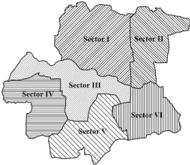
For the purpose of planning, the city area is divided into six sectors. The approximate projected population of these sectors is given in the following table. These approximate projected populations are considered for planning purpose.
Projected Population for Year 2026 & 2036
Sector
2026
2036
I
4,24,500
5,89,000
II
59,000
81,900
III
9,67,100
13,42,200
IV
4,29,500
5,96,000
V
1,65,300
2,29,400
VI
4,04,600
5,61,500
Total
24,50,000
34,00,000
10.9Development Control
A set of Development Control and Promotion Regulations has been framed considering the existing regulations in various cities of the State. These regulations are made user friendly and many new concepts have been incorporated so as to boost to the development. Therefore, these regulations have been named as “Development Control and Promotion Regulations 2015, Nashik”. The detailed provisions are given in the set of DCPR Nashik -2015. However, main features of DCPR Nashik -2015 are as follows.
The regulations are made simpler, without ambiguity and user-friendly.
The matters relating to particular subject are organized in the same part.
The powers of interpreting the provisions of DCPR and taking decisions on some matters related to Development Plan, are given to Municipal Commissioner, to decide the issues at local level only.
The contents of regulations are categorized in 12 parts according to the subjects.
Net area is treated as equivalent to the gross area and for plotted layout, distribution of FSI is proposed on pro-rata basis for encouraging the plotted development and thereby making more roads /streets available for movement of pedestrians.
Compulsory provision of Amenity Space in any development proposal at the time of approval for creating amenities in the city. This will distribute the burden of land required for amenity amongst the owners of the land which will ultimately reduce the inequality to great extent created by imposition of reservations on lands.
The base FSI for higher roads have been increased to 1.1 or 1.2 depending on the road width, so as to densify the main transport corridors.
More FSI is proposed in the DCPR so as to create more housing stock and also give impetus to other activities. However, all areas excluding balcony and double height terraces shall be computed in FSI. Since in sanctioned DCR of Nashik City, staircases are not computed in FSI, in new DCPR net area is treated as gross area to compensate this gap. In other cities, the areas under passages are generally exempted from FSI with payment of premium. Keeping this in view and other factors related to this, the premium FSI of 0.30 is allowed with the premium at 10% of ASR. In addition to this Fungible FSI is also provided in the regulations. This fungible FSI is nothing but additional FSI with a payment of higher premium. This FSI of 0.30 is subject to payment of premium at 40% land rate of ASR. In total FSI of 0.6, over the basic FSI is allowed.
So as to consume premium/ paid FSI and TDR, limit of utilization of FSI on a plot is increased considerably. This limit also varies with the width of road. More the width, more is the utilization limit. This is proposed to get the market to TDR and also densify major transportation corridors.
A height of buildings that will be allowed by the Fire Authority is made permissible so as to create
more ground space for recreation and other activities.
Norms for special building have been re-drafted so that burden of additional fire escape staircase get reduced and ultimately saves the construction cost. This is done on the analogy of provisions in the DCR of some other cities. This will also help in creating housing stock for weaker section at low cost.
List of uses permissible in the every land use zone is made exhaustive and more uses are made permissible to bring about flexibility in the development.
The provisions of TDR in lieu of reserved land have been made lucrative so that land owners come forward for surrender of land under reservation to the planning authority without hesitation. This will increase the implementation of Development Plan to a desired level.
The development of reservations through accommodation reservation principle has been made rational so that owner of the land gets every benefit for which he, otherwise, would have been entitled. Moreover, reservations like play-ground, park have been brought under this concept with rational provisions so as to make these amenities available for general public.
TDR for construction of amenity has also been proposed to make construction of amenities possible through private participation.
New provisions like, redevelopment of core area, slum redevelopment are incorporated to make possible planned development of these areas.
Transit Oriented Development is also important aspect to be taken care in the DCPR. Consultations were made in this regard with some NGOs working in this field. The provision in this regard is also incorporated in the DCPR.
10.10Social Amenities
To ensure orderly development of the city, land use zoning, traffic transportation network and development control are the foremost important aspects, that needs to be taken care in Development Plan. However, Development Plan also aims at creating an environment to enable the residents to enjoy the desired standard of living conditions. For that purpose, various amenities need to be created through Development Plan. Reserving the land for such amenities is first primary step in this regard. However, acquisition of these sites should not go beyond the financial capacity of the planning authority.
Provisions of section 31(5) stipulates that if a Development Plan contains any proposal for the designation of any land for a purpose specified in clause of (b) and (c) of section 22, and if such land does not vest in the planning authority, the State Government shall not include that purpose in the Development Plan, unless it is satisfied that the Planning Authority will be able to acquire such land by private agreement or compulsory acquisition not later than 10 years from the date on which the Development Plan comes into operation.
From the provisions, it is very clear that the reservation of sites for public amenities should be such that it is within the capacity of the Planning Authority to acquire these sites within a period of 10 years. Moreover, issue of maintaining of these amenities is of more importance than creation of amenities. Many created amenities remain unused because of improper maintenance and lead to misuse in many cases. Therefore, amenities need to be created at threshold level.
Now a days it is becoming a matter of more concern to the land owners, whose lands are reserved in the Development Plan. They invariably appose to such reservation which gives rise to public agitation against the Development Plan. Imposing of reservation also creates inequality amongst the persons. This problem is aggravating day by day. Keeping this in mind, the amenities are proposed.
10.10.1City level amenities
It is necessary to make grouping of amenities that would necessarily be created through Development Plan and that would likely to be created by private sector. Some specific amenities like town level parks, playground can only be created through the proposals of Development Plan because such amenities may not be created through any other means if lands not reserved in Development Plan. Moreover, the lands for public utilities like water supply and sewage installation, solid waste management, cremation and burial ground, need to be earmarked in the Development Plan because these activities are more or less location specific and land for them, at particular location, may not be available in future. Therefore, emphasis is given only to reserve land for such type of purposes and various provisions have been made thereby making acquisition / development of such land simpler and beneficial to both, owner and Planning Authority. Considering the various studies carried out in this regard, the planning standards adopted for making provisions of these amenities are given in following table.
Planning Standard Adopted
Planning Standard Adopted
Planning Standard Adopted
Planning Standard Adopted
Sr. No.
City Level amenities
Area
Min units Required
1
Sewage treatment plant
As per requirement of NMC
--
2
Water works
As per requirement of NMC
--
3
Municipal solid waste facility
As per requirement of NMC
--
4
City level main fire station /Fire station
As per requirement of NMC
--
5
Park (Town level)
Each site 3.00 hectare.
1 site for 0.50 lack population
6
Play Ground / Stadium / Sports complex
Each site 3.00 hectare.
1 site for 0.50 lack population
7
Exhibition ground
Each site 3.00 hectare.
1 site for 10 lack population
8
Auditorium
1.00 hectare.
1 site for 5 lakh population
9
District Hospital (100 beds)
Area @ 65 sq.m. / bed 0.65 hectare.
1 for city
10
Municipal Market
0.20 hectare.
2 nos in each sector.
11
Parking
As per requirement.
--
12
Hawkers zone
As per requirement.
--
13
Cremation ground/ Burial ground
As per requirement.
--
14
Slaughter House
0.20 hectare
As per requirement
15
Truck Terminus
As per requirement
--
16
MSEDCL
As per requirement of MSEDCL
--
17
Bus Stand - MSRTC
As per requirement of MSRTC
--
10.5Planning Sectors
For the purpose of ascertaining the adequacy of the amenities, the city is divided into six sectors considering the character of the area. Following table and map shows the area covered in each sector.
The total area within the Nashik Municipal Corporation limits has been divided into six sectors. The projected population of the year 2036 has been distributed among these sectors for framing zoning and detailed planning proposals. The proposed land use classification for the entire area is given in table below.
Proposed Land Use Analysis
Sr. No.
Land Use
Area in Hectares
% of total Developed Areas
% to the Total Area
1
Residential
12835.78
60.98
47.99
2
Future Urbanisable zone
442.19
2.10
1.65
3
Commercial
118.53
0.56
0.44
4
Industrial
1558.63
7.41
5.83
5
Public and Semi-Public
1059.64
5.03
3.96
6
Public Utility
293
1.39
1.10
7
Transportation
2862.9
13.60
10.70
8
Garden, Play Ground and Recreation
535.84
2.55
2.00
9
Military
943.75
4.48
3.53
10
C.I.D.C.O
398
1.89
1.49
Total Developed Area
21048.26
100.00
78.69
11
Agricultural
4542.59
16.98
12
Water Bodies
906.23
3.39
13
Vacant Land
0.00
0.00
14
Forest
250.67
0.94
Total Un-developed Area
5699.49
21.31
Total Area
26747.75
100.00
10.8.1 Residential Zone
The residential zone is generally proposed so as to accommodate projected population at the end of plan period i.e. for the year 2036. The density of population is generally considered as 250 persons per hectare. The spread of residential zone should be such that the corporation should be able to extend the infrastructure at minimum cost. In other words, the extent of zoning should be compact. This also helps in developing the effective mass transportation system. However, other side of the coin is that the lands in urban area are always under pressure of development because of so many reasons. If these lands are prohibited form development legally, it tends to un-authorised development and the problem becomes manifold. Moreover, supply of more residential land in the market helps in creation of more housing stock which ultimately helps in keeping the prices under control. Therefore, zoning needs to be proposed
rationally. In this Development Plan, in addition to 7347.68 Hectares of residential zone of earlier sanctioned Development Plan, 5488.10 Hectares of land have been proposed for residential zone, which works out to a total of 12835.78 Hectares.
While proposing for residential zone following aspects are also taken into consideration.
a) Trend of development
b) Contiguity with existing or proposed development
c) Vicinity to major road links
d) Major existing or proposed work centres
e) Physiography of the area
The land proposed in the residential zone constitutes, 47.99 % of the total land.
10.8.2 Future Urbanizable Zone
The areas which are adjacent to proposed residential zone but will be under pressure of development are shown in future urbanizable zone. This future urbanizable zone is a residential zone, however, development permission is subject to provision of on site and off site infrastructure at the cost of owner himself. The detail provision in this regard is given in Development Control and Promotion Regulations. This zone is proposed in village Pathardi & Makhmalabad covering an area of 442.19 Hectares, which constitute 1.65% of the total area. The density of population together of residential and future urbanisable zone works out to be 256 persons per Hectares.
The residential zone and future urbanisable zone, and projected population on the basis of existing population in said sector is given in table below. It is expected that, because of better amenities in the newly developed area, the population will move to these areas from other crowded parts of the city.
Sector
Residential area
Population
Residential
Future urbanisable
Total
Year 2036
I
3387.76
159.04
3546.80
589000
II
1485.93
0.00
1485.93
81900
III
2796.37
0.00
2796.37
1342200
IV
1420.08
0.00
1420.08
596000
V
2023.40
283.15
2306.55
229400
VI
1722.24
0.00
1722.24
561500
Total
12835.78
442.19
12994.82
3400000
10.8.3 Commercial Zone
In the city where there is predominant commercial activity, such areas have been shown in Development Plan in commercial zone. In addition to this, sites reserved for commercial purposes like municipal markets, shopping centers, vegetable markets, etc., are shown in commercial zone. No more
commercial zone is proposed in the Development Plan because, all sorts of commercial activities are allowed in R-2 Zone. Some sites are reserved for Municipal Markets in the Development Plan and are well distributed. The total commercial zone shown in the plan is 118.53 Hectares, which constitutes 0.44 % of the total area.
10.8.4 Industrial Zone
In the sanctioned Development Plan, 1661.35 Hectares of land was shown in industrial zone which includes Satpur (M.I.D.C), Ambad (M.I.D.C), Nashik Industrial Cooperative Estate and Industrial area of Kirloskar and Railway Traction center in Deolali and Chadegaon village.
The policy about industrial zoning adopted in this plan is that the owners those who have requested for industrial zone, their lands have been zoned for Industrial purpose. No more lands have been zoned for industrial purpose except some adjacent lands which are required to be included in the same zone to achieve compactness. Also those land from Chadegaon which were shown in industrial zone in sanctioned Development plan but not put to industrial use are shown in adjoining agriculture zone. Such industrial zone is proposed on 75.56 Hectares lands in Parthardi, 13.00 Hectare lands in Satpur. Total Industrial zone in corporation limits works out to be 1558.63 hectare which is 5.83% of the total area.
This Development Plan also envisages the provision for allowing industrial use in agricultural zone, subject to some conditions.
10.8.5 Public Semi-public zone.
The lands which are predominantly being used for public semi-public activities like premises of Government and Semi Government offices, educational institutions, health facilities, etc. and reservations for public semi-public purpose are shown in public semi-public zone. The total area under public semi-public zone is 1059.64 Hectares, which is 3.96 % of the total area.
Uses permissible under this zone have been elaborately mentioned in land use classification of Development Control and Promotion Regulations.
10.8.6 Agricultural Zone
Effort has been made to retain good fertile land in agricultural zone. However, the lands which are required for future population or in contiguity of existing development or proposed developable zone have to be included in developable zone. The lands having steeper slopes are retained in agricultural zone. In proposed land use, 4542.59 Hectares of land is covered under agricultural zone which constitute 16.98% of the total area of the Corporation. Some activities are made permissible in agricultural zone which are listed in land use classification chapter of Development Control and Promotion Regulations.
Town planning schemes are also allowed in this zone subject to condition that cost of the scheme shall be borne by the owners. The lands under this scheme shall be deemed to be converted in residential zone as soon as the final scheme is sanctioned by the State Government u/s 86 of the act. This also shall be subject to provision of minimum 24 m. wide road network within scheme area. This is proposed to achieve plan development of the area without infrastructure burden on the planning authority and also reduce threat of unauthorised development.
10.8.7 Green Belt
There are four rivers, i.e. Godavari, Nasardi, Valdevei, Darna flowing through the city. The flood
lines i.e. Blue line (Prohibitive zone) and Red line (Restrictive Zone) are earmarked on plan as low flood lines and high flood lines for these rivers except Darna. The Green Belt of 18 m. for Godavari River, 15 m for Nasardi, Valdevi and Darna Rivers is provided along the banks. This belt shall be a use for plantation, cycle track, recreation, etc. which will protect the erosion of the river banks and also enhance the environment.
10.8.8 Water Bodies
Four main rivers are flowing within the Nashik Municipal Corporation limits namely –Godavari, Nasardi, Valdevi, Darna and one Waghadi stream. In addition, there are lakes at Adgaon, Gangapur etc. and canals, nallas, water streams which are shown as water bodies in the Development Plan. The right bank canal of Gangapur Dam is currently not in operation and land is handed over to Corporation. The left bank canal is in operation. Some proposals are shown in this canal land.
The area covered under water bodies is 906.23 Hectares, which constitute 3.39 % of the total area.
10.8.9 Forest Land
The forest lands are shown as it is, which admeasures about 250.67 Hectares and constitutes 0.94% of the total area. These are at Pathardi, Mahsrul, Makhmalabad, and Gangapur.
10.8.10 Transportation network
A comprehensive transportation network is proposed in the Development Plan. There are National and State Highways passing through the city.
Other amenities include education, health, markets, library and parking etc. The share of amenities like education, health, commercial, etc., have been taken over to great extent by private sector. Still, some share of primary and secondary education, public health will have to be borne by the Corporation. Some amenities like vegetable market will have to be provided by the Corporation. This Development Plan envisage to part with some percentage of the land, as amenity space to the Corporation at the time of development permission by the owner / developer in lieu of in-situ FSI or TDR to make land available for such amenities. The owner / developer has also been given choice of constructing some specific amenities if he desires so. This provision has been elaborately mentioned in the DCPR. The quantum of these other amenities is worked out considering the following planning standards. The sites worked out for these amenities shall be called as ‘Notional Reservations’. Notional reservations are the reservations which are not earmarked on the Development Plan but the amenities envisaged under the said reservations shall be created through amenity spaces to be obtained through the regulation no.13.4 of the DCPR. The notional reservations worked out as per following planning norms, will work as guidelines to utilise the above said amenity spaces for creation of such amenities on priority depending upon the requirement in the area. Planning standards adopted for these ‘Notional Reservations’ are as given below.
Sr.no.
Public Purpose
Requirement
1
Education
Primary school
Primary school going population 9% 3 sq.mt/student (exclusive of playground) One site of 0.40 H. preferably for 1000 students 25% burden to be shared by NMC.
High school
Secondary school going population 7% 4 sq.mt/student (exclusive of playground) One site of 0.4 H. preferably for 1000 students 3% burden to be shared by NMC.
2
Medical Amenity
1 site of 0.20 H. for 10000 population 20% burden to be shared by NMC.
3
Vegetable market
Each site preferably of 0.15 hectare / 25,000 populations or as per requirement.
10.10.3Sites in earlier sanctioned Development Plan
There are in all 538 sites reserved in the sanctioned Developed Plan. Out of which 87 sites have
been developed. 21 sites are deleted in pursuance of notice under section 127 or 49 of the Act by the Courts/ Government orders. Some sites have been encroached upon. Excluding these sites, in cases where acquisition is going on, purpose of the site is retained as it is or similar to original. Nomenclature of remaining sites is modified as “Public Amenity” so as to keep flexibility in development of the amenity as per the requirement of the surrounding area. The deviation statement showing details of the reservation from the earlier sanctioned Development Plan is given in Table A.
10.10.4Proposed reservations for city level amenities.
The Table B annexed to this report gives the details about every site reserved in this revised Development Plan. The Table also gives the details about the S. No / C.T.S No/ F. P. No, etc. of the site, its area, its approximate cost of acquisition and probable cost of development, appropriate authority fo whom the site has been reserved in Development Plan etc. Each of the site so reserved has been distinctly shown on the purposed land use plan with red verge, indicating the purpose of amenity and its number corresponding to that shown in this table.
The Table C annexed to this report gives the requirement of site for various amenities for population of 24,50,000 for the year 2026, existing amenities and proposed amenities in this Development Plan. Table C1 to C6 gives the details of sector wise amenities provided.
Sewage Treatment Plant – 7 Sites for S.T.P have been proposed as per the demand and in consultation with the head of the concerned department of the Corporation, at Satpur, Pimpalgaon Khamb, Gangapur, Nashik and Makhamalabad and are listed in Table B.
Water works – 31 Sites for water treatment plants and reservoirs have been proposed under common nomenclature as “Water Works” as per the demand and in consultation with the head of the concerned department of the Corporation at various places and are listed in Table B.
Municipal Solid Waste Facility – There is an existing “Khat Prakalp” in village Pathardi. Extension to this site is proposed as per the demand and in consultation with the head of the concerned department of the Corporation. Moreover, existing reservation at village Makhamalabad is retained. These reservations are listed in Table B.
Main Fire station and Fire stations – The existing main fire station is at Shingada Talav area and other three Fire Station are existing. Considering the requirement for proposed population, in all 12 sites are proposed as per the demand and in consultation with the head of the concerned department of the Corporation. These reservations are listed in Table B.
Park (Town Level) – For the population of 2026, total 49 sites for park are necessary. Considering the existing sites about 22, new 89 sites are proposed in the Development Plan. Some of the sites from the earlier sanctioned Development Plan are of smaller sizes and therefore the number is higher and are listed in Table B.
Play Ground / Stadium / Sports complex - For the population of 2026, total 49 sites for playground are necessary. Considering the existing sites about 17, new 57 sites are proposed in the Development Plan and are listed in Table B.
Exhibition Ground – There is 1 place which is used for Exhibition / Fair Ground. However, suitable places are necessary for assembly or exhibition or fair like activities since these activities are important. Considering the proposed population 3 sites are proposed in the Development Plan. These
reservations are listed in Table B.
Auditorium – There are 5 Auditorium / Town Hall / Natya Griha, 3 at centrally developed area, 1 at Deolali village and 1 at Satpur village. 2 more sites are proposed and are listed in Table B.
District Hospital – There are 4 Government hospitals and 5 hospitals of the corporation for the general public in existence. These facilities are in the developed area of earlier sanctioned Development Plan. Considering the sites reserved in the earlier sanctioned Development plan, 13 sites are reserved in this Development Plan and are listed in Table B. More sites, if required, may be made available through amenity spaces.
Municipal Market – To create commercial activity like Petty shop, vegetable market, shopping centre, hawkers place, NMC offices, etc., organized commercial place is necessary. Therefore, 36 reservations of Municipal Market and 7 of vegetable market are proposed including those retained from sanctioned plan and are listed in Table B.
Parking – 23 reservations are proposed as per requirement and are listed in Table B. Moreover, the land which would be handed over to the Corporation through the regulation of Amenity Space, can be made available for this purpose.
Hawkers Zone – 3 reservations are proposed as per requirement and are listed in Table B. Moreover, the land which would be handed over to the Corporation through the regulation of Amenity Space, can be made available for this purpose.
Cremation Ground / Burial Ground – At present there are 45 number of sites existing for cremation/ burial ground. Considering the requirement for proposed population, in all 29 sites are proposed in the Development Plan. These reservations are listed in Table B.
Slaughter House – There is l slaughter house in existence. Considering the requirement, 1 sites is proposed as per the demand and in consultation with the head of the concerned department of the Corporation. These reservations are listed in Table B.
Truck Terminus – 4 reservations are proposed as per requirement and are listed in Table B.
MSEDCL – No definite requirement with commitment of acquisition is received from MSDCL. Still one site is proposed. Moreover, the land which would be handed over to the Corporation through the regulation of Amenity Space, can be made available for the MSEDCL, if required.
Bus Stand – No definite requirement with commitment of acquisition is received from MSRTC. However, 6 new sites are proposed, keeping in view the requirement and sites reserved in earlier sanctioned Development Plan and are listed in Table B. Moreover, the land which would be handed over to the Corporation through the regulation of Amenity Space can be made available for this purpose.
Public Amenity – To have flexibility in development of an amenity, the sites which were reserved in sanctioned Development Plan for various purposes, are retained in this plan under the nomenclature of Public Amenity. There are 93 such sites in the Development Plan. These sites can be developed for any public purpose as may be decided by the Municipal Commissioner.
10.6Need for Paradigm Shift
As per the provisions of section 22 of the Maharashtra Regional and Town Planning Act, 1966, the Development Plan shall provide so far as may be necessary for all or any of the following matters, that is to say,
(a) proposals for allocating the use of land for purposes, such as residential, industrial, commercial, agricultural, recreational;
(b) proposals for designation of land for public purpose, such as schools, colleges and other educational institutions, medical and public health institutions, markets, social welfare and cultural institutions, theatres and places for public entertainment, or public assembly, museums, art galleries, religious buildings and government and other public buildings as may from time to time be approved by the State Government;
(c) proposals for designation of areas for open spaces, playgrounds, stadia, zoological gardens, green belts, nature reserves, sanctuaries and dairies;
(d) transports and communications, such as roads, high-ways, park ways, railways, water-ways, canals and airports, including their extension and development;
(e) water supply, drainage, sewerage, sewage disposal, other public utilities, amenities and services including electricity and gas;
(f) reservation of land for community facilities and services;
Further clauses (g) to (l) mentions the other matters and clause (m) provides for
(m) provisions for permission to be granted for controlling and regulating the use and development of land within the jurisdiction of local authority.
From the above provisions it is clear that, Development Plan can be prepared for one or more matters mentioned above.
Provisions of section 31(5) stipulates that if a Development Plan contains any proposal for the designation of any land for a purpose specified in clause of (b) and (c) of section 22, and if such land does not vest in the Planning Authority, the State Government shall not include that purpose in the Development Plan, unless it is satisfied that the Planning Authority will be able to acquire such land by private agreement or compulsory acquisition not later than 10 years from the date on which the Development Plan comes into operation.
From this provision, it is very clear that the reservation of sites for public amenities should be such that it is within the capacity of the Planning Authority to acquire these sites within a period of 10 years.
Now days, Development Plan is becoming a matter of more concern to the land owners, whose lands are reserved in the Development Plan. They invariably appose to such reservations which gives rise to public agitation against the Development Plan. Imposing of reservation also creates inequality amongst the persons. This problem is aggravating day by day. However, not all, but some specific amenities like town level parks, playground need to be made available through the proposals of Development Plan because such amenities may not be created through any other means if lands not reserved in Development Plan. Moreover, the lands for public utilities like water supply and sewage installation, solid waste management, cremation and burial ground, need to be earmarked in the Development Plan because these activities are more or less location specific and land for them at particular location may not be available in future. Therefore, emphasis is given only to reserve land for such type of purposes and various provisions have been made thereby making acquisition / development of such land simpler and beneficial to both, owner and Planning Authority.
10.10.5Neighbourhood level Amenities through Notional Reservations;
The lands are physically earmarked or reserved for different town level amenities in the Development Plan. Other amenities, mentioned below are expected to be created on the land which would
be available through the regulation of Amenity Space. Since these reservations are not earmarked on the Development Plan, these are termed as Notional Reservations. The requirement of these Notional Reservations is worked out so as to guide the Municipal Commissioner, to utilise the amenity spaces to be handed over to Municipal Corporation for development of specific amenities.
a) Primary Schools – There are 33 sites reserved for educational amenity in this Development Plan and are listed in Table B.
The study of existing primary educational amenities shows that about 75% burden of this facility is taken over by private sector whereas about 25% burden is shouldered by Municipal Corporation. The contribution of private sector will increase day by day. Keeping this aspect in mind, provision for 25% primary school going population need to be met by the Corporation. The figures of primary school going population received from concerned department show that about 9% of the population is primary school going. 9% of the projected population i.e. 24,50,000 for year 2026 will be 2,20,500 students. Out of this, 25% requirement i.e. 55,125 students, is supposed to be fulfilled by the Corporation. There are 129 Corporation schools having 36,613 admitted students. Considering this, provision for 18512 students need to be made. Considering one site for 1000 students, 19 sites need to be reserved. In this Development Plan 33 sites for Educational Amenity are reserved. If more sites are required in newly opened-up area for development, requirement can be met through the regulation of amenity spaces.
b) High Schools - There are 33 sites reserved for educational amenity in this Development Plan and are listed in Table B.
The study of existing secondary educational amenities shows that about 97% burden of this facility is taken over by private sector whereas about 3% burden is shouldered by Municipal Corporation. The contribution of private sector will increase day by day. Keeping this aspect in mind, provision for 3% High school going population need to be met by the Corporation. There are 13 Corporation high schools having 3,336 admitted students. Considering one site for 1000 students, 4 sites need to be reserved. In this Development Plan 33 sites for Educational Amenity are reserved which will meet the requirement. If more sites are required in newly opened-up area for development, requirement can be met through the regulation of amenity spaces.
In addition to this, road networks of 18m roads are proposed. Following table shows the road length in kilometers of each type of roads.
Width
18m
24m
30m
36m
45m
60m
Total
Length (km)
363.53
124.08
170.18
16.31
13.12
48.67
735.9
Some length of Development Plan roads are shown as dotted on the Development Plan and indicated as ‘Roads to be implemented at the time of re-development’. This proposal envisages that proposed road width shall be implemented at the time of re-development of property. However, if the land
is vacant, this proposal shall be implemented as that of firm line road proposal.
It is expected that this comprehensive road network will improve the connectivity and facilitate the transportation. Further, these roads should have provisions for cycle tracks and pedestrian way and construction of road should be undertaken accordingly in future. For this purpose road section for proposed roads are annexed in this report as Plan no.1, 2, 3, 4, 5 and 6. These sections may be suitably modified if mass rapid transportation system is implemented on these roads.
The share of other amenities like education, medical, commercial, etc., have been taken over to great extent by private sector. Some share of primary and secondary education, public health will have to be borne by the Corporation. Some amenities like vegetable market will have to be provided by the Corporation. It will not be appropriate to reserve the lands for all these amenities in the Development Plan because it will be against the provisions of section 31(5) of the Act considering the financial position of Corporation and level of implementation of the sanctioned Development Plan. This Development Plan envisage to part with some percentage of the land to the corporation at the time of development permission by the owner / developer in lieu of in-situ FSI or TDR to make available land for such amenities. The owners / developers have also been given choice of constructing such amenities if they desire so.
The provisions of TDR have been worked out technically so as to make this another form of compensation more rational. This will benefit both, owner and the Corporation because, owner will be inclined to hand over the land and the corporation will get reserved land at a faster rate. This will also apply to Development Plan roads which will open up new areas for development at faster rate. In addition to this, the development of reserved sites through accommodation reservation principal has been made more rational. All these measures will lead to reduce personal inequality and in the result, implementation of the Development Plan will get momentum.
Keeping this as a central idea, the Development Plan proposals are framed which are mentioned in foregoing paras.
Floor Space Index
FSI is considered as a tool for containment of growth and density. By fixing FSI limit, it is assumed that the proper development would undertake within the area with desired density. The main reason behind this is also not to overburden the existing infrastructure. The past experiences have shown that fixing FSI limit does not contain the growth as desired, but give rise to unauthorized development and leads to urban sprawl. With this concept, we have also failed to control the prices of houses and dream of home has gone beyond the reach of common man and poor persons. Therefore, we need to rethink about this paradigm. If FSI is increased and major corridors are allowed to be densified, then, problem of housing will ease to great extent and also population living along major corridors will opt for public transport. If infrastructure gets overburdened, it can be augmented from the premium charges to be levied on additional FSI.
Since both the amenities i.e. primary and high school are generally run in one premises, these amenities can be developed in single premises.
c) Community Centers & Library – The amenities of community center & library can be created, wherever necessary, on the land to be obtained through regulation of amenities spaces or on the sites reserved for public amenity.
d) Provision for other amenities – The requirement of any other amenity can be met through the land to be obtained through regulation of amenities spaces or sites reserved for public amenity.
e) Utilization of land obtained through regulation of amenity space - The land obtained through the regulation of amenity space, shall be utilised by the Municipal Commissioner on priority for the notional reservations mentioned above depending upon the need of the area in consonance with the provisions of the said regulation. Such land remained unutilised, shall be utilised for any of amenity in the area, depending upon the need, by the Municipal Commissioner. Moreover, such amenity spaces may also
allowed to be developed by the owner subject to the provisions in the said regulations.
10.7Paradigm Shift
As discussed in foregoing paragraphs, the paradigm shift envisaged in this Development Plan is given below.
Sr.No.
Present paradigm
Paradigm shift
1.
Provisions of reservations in the Development Plan for all the purposes mentioned in section 22 of the Act by adopting planning standards of 1979, overlooking the provisions of section 31(5) of the Act which are mandatory.
Provision of only town level amenities in the Development Plan, with due regard to the provisions of section 31(5) of the Act. Provision of other amenities through amenity space to be obtained at the time of development permission.
2.
Fixing of FSI limit traditionally.
Moderate increase in FSI with moderate premium charges.
3.
Uniform FSI irrespective of road width.
More base FSI, for plots fronting on wider roads
4.
Utilisation of FSI/ TDR irrespective of road width
Steep rise in utilization of premium FSI and TDR to densify the major corridors.
5.
Entitlement of TDR equivalent to the area surrendered in developable zone.
Entitlement of TDR taking into consideration basic difference in value of land and value of TDR.