Region is a contiguous geographical area, which has a fair degree of uniformity, in administration, economic linkages or natural environment. It is relatively a large area, with hierarchy of settlements and varying landscape.
Urbanisation has accelerated in the past few decades while planning in India has been largely limited to urban settlements and the space between cities and their surroundings has been growing in an unplanned haphazard manner. Centrifugal forces attract huge volume of migrant population to urban centres, which has rendered short the planning efforts of local bodies. The resultant biases in demography have also had negative implications in the development at the source of migration. Thus, urban centres & its surrounding settlements have two-way interrelationship in terms of cause and effect of many elements. Accordingly, planning as an exercise should not be exclusively limited to urban settlements but a region can be identified to have holistic development of growth promoting centres and surrounding subsequent hierarchy of settlements. This should facilitate optimal planning and development of infrastructure in cities along with the adjoining rural areas and strengthen the economic links in the region.
The paradigm of regional development has evolved through the years after Independence. Most important ones are district planning, metropolitan planning, watershed management and special area development. The Planning Commission has also developed methods for regionalisation and policy guidance for preparation of development plans for regions. A number of such case studies have been taken up by the State Governments for development of special regions. Considering the importance of regional planning at the district level and with the view to integrating the urban and regional development, the DPC and MPC were created through the 73 rd and 74 th CAA.
4.2Aspects of Regional Planning
The preliminary aspects of regional planning may constitute the following, which highlight the advantages of the approach:
Sustainability - Sustainability leads to balance in Regional Development which implies efficient use of available resources and opportunities for development in all parts of the region. Sustainability of regional planning depends upon:
i. Management of major environmental inputs namely water (both surface and ground), minerals, maintenance of green cover, protection of sensitive environmental areas and linking areas with special opportunities for development like religious, archaeological etc.
ii. Balanced and equitable spatial and economic development of the region
iii. Effective Use of local resources including cultural resources such as art & crafts. Sustainability based regional development can provide solutions for elevation of urban poverty, minimisation of urban sprawl and managing migration, which are majorly outcomes of lack of regional planning.
Environment – Some of the major environmental concerns that can be addressed by regional planning approach are the following:
i. Control of pollution specially water pollution, use and maintenance of the water courses.
ii. Maintenance of green cover, forests and eco fragile areas.
iii. Control and regulation of activities which have impact on environment.
While planning, the environmentally sensitive areas should be identified which are non-conducive for development. Such areas should be either protected or developed while following relevant standards.
Disaster Management – The impact of natural disasters is exaggerated by unscientific plus unplanned development. Regional development should promote efficient response and preparedness to disasters such as floods, landslides, land subsistence, fire and earthquake. The Disaster Management Act, 2005 makes it mandatory to prepare Disaster Management Plan at State and District level. Integration of hazard (micro) zoning in planning activities is more facilitative and responding at regional level which can be integrated with the provisions of NDMA. Zoning hazards and its holistic approach can be achieved largely at the regional level scale or better at city level. Thus, regional planning is the solution to integrated response.
Promoting Balanced Development - Imbalanced development of the country due to missing regional planning approach to bring development in urban-rural settlements simultaneously has led to lopsided development in favour of urban settlements. As a result centripetal and centrifugal forces of human movement have come to work with intensity in the urban parts of the country. Lack of integrated spatial planning specially in the influence area of metropolitan cities has led to ‘rural push’. Migration across administrative boundaries to the cities without adequate functional infrastructure to support the population puts pressure on the administrative departments. On the other hand the areas from where out-migration takes place suffer with imbalance growth. Thus, an integrated planning approach is required to provide administrative solution for provision of sustainable infrastructure in the region and vision development of the peri-urban areas & counter magnets.
Inclusivity – Regional planning can bring inclusivity in broader area by preparing plan after considering issues, strengths and prospects of a large spatial unit. Regional disparities especially peri-urban areas surrounding large cities and metropolitans present contrasting conditions both physically and social-economically. Regional planning can efficiently tackle the problem arising out of the transition of rural area into peri-urban and urban areas. Inclusive development principles can bridge the gap present in terms of regional disparity in India.
4.3Planning Regions in India
The increasing need of urbanisation further aggravated by the rural push factors is directly affecting the quality of life and environment. Such areas shall not be merely left to the factors of natural growth and can be identified for Regional
planning. A region is a flexible concept and can be referred to as a continuous and localised area intermediate between National and Urban levels.
The District Planning Committees is to be the single decision making committee, which can address to the issues of planning in the District. In many States, DPC's are not constituted, however, in some of them, the Town and Country Planning Acts provides a legal framework for constitution of Regional Development Authorities. For example, the Bombay Metropolitan Region Development Authority Act, 1974 makes it mandatory to constitute the Metropolitan Regional Development Authority for the planning and development of Mumbai metropolitan city.
Whenever functional areas cut across different State boundaries there may be problems of co-ordination in administration. Ideally in such cases, a unified RDA (for this specified region) may be instituted with representation from each of the State.
In the present scenario, Indian metropolitan cities have planned development, which partially satisfies the aim of the 73rd & 74th CAA, however, incomplete adherence of the Act has resulted into lack of holistic planning. Thus, it is required that state governments amend respective State Town and Country Planning Acts and provide a structure of regional planning with appropriate administrative structure to carry out its preparation and implementation.
Such regions are holistic from administrative point of view and there are little chances of conflict when there is a single administrative unit. The present planning system for only urban settlements has developed islands of growth centres, creating vast disparity. Planning for district as a region is the approach in which country as whole can be covered in planning exercise leaving no intermediate space. Thus, for convenience of administration of regions and entire coverage of country under planned development the structure of regional planning should be followed.
The 12 th Five Year Plan has emphasised on regional development particularly DPC composition to control and regulate unplanned development beyond the urban areas i.e. urban sprawl/ scatter. The State T&CP Acts provide statutory setup for urban and regional planning and development. In many States Special Area Planning Acts, similar to Regional Planning, are also in place.
Transport linkages play an integral role in the growth of urban nodes. As movement of goods, services and alignment of infrastructure follow the transport network while the human settlement and economic activities generally follow the transport lines. Lately, Government of India has recognised the potential of transport corridors as instrument of imparting economic push to
large region and thus has been implementing programmes, which are spread across a large region like, Delhi Mumbai Industrial Corridor (DMIC) Programme. The objective of DMIC project is to expand India's manufacturing and service base and develop DMIC as a "Global Manufacturing and Trading Hub". The project will provide a major impetus to planned urbanization in India with manufacturing as the key driver.1.
The National Highway Development Programme (NHDP) was launched in 2000 to upgrade and strengthen National Highways and one of the advantages identified under the NHDP is all round development of areas. Other transport oriented regional corridors conceptualised are the Eastern and Western Freight Corridors. Keeping these developments in mind, Transit Oriented Development (TOD) approach to plan and develop regions can be adopted.
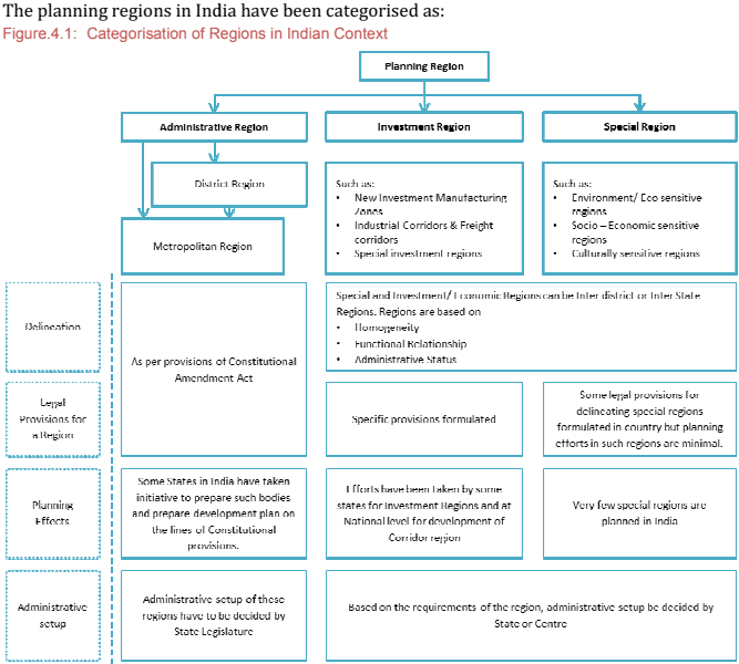
There are other types of regions as well, which have homogeneity and linkages in terms of investment, tourism and natural environment. In India, owing to its vast stretch and heterogeneity, multiple/different typologies of regions could be adopted for planned development. The regional planning approach is suggested in these guidelines for planned and sustainable development of the human settlements.
Source: Compilation from 73 rd & 74 th CAA, State Administrative set-ups and regional planning cases in India
4.3.1District as a Planning Region
India has 640 districts and according to Census of India, 2011, 67% districts are urbanised upto 50% out of which approximately 7% have crossed the line of 40% urbanisation. New Delhi, Central Delhi, Kolkata, Mumbai, Mumbai Suburban, Hyderabad, Chennai, Yanam and Mahe (in Puducherry) are 9 districts which are 100% urbanized. However, there are many other districts which have rural-urban character and have a fast rate of urbanisation. Therefore, the urban trend of these districts should be planned. Efforts to direct urbanisation of such districts will sync the growth of cities with goals of national development.
District as a unit is a holistic concept which administratively provides a strong foundation for planning. The hierarchy of settlements and natural resources
available in relatively larger region are other additional reasons which make district a unit of planning more logical premise.
4.3.1.1 Need for Administrative Structure
Administrative structure to guide planning at district level is important. The 74 th Constitutional Amendment Act provides that the State Legislature should provide for the composition of District Planning Committee (DPC) given that there shall be elected representatives of Panchayats and municipalities in committee in proportionate ratio. For this, State Governments are required to amend existing or enact new laws to introduce DPC in planning administration structure.
4.3.1.2 Process of planning at District level
In India, planning process for administrative areas equal to or bigger than district has been attempted.
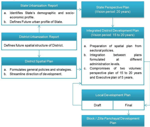
Kerala: The State of Kerala has provision for DPC and MPC. Its methodology of District plan preparation provides for a decentralised planning process by initiating preparation of an Integrated District Development Plan (IDDP) along with Local Development Plans (LDP) for every local government in the district in an integrated manner. The Integrated District Development Plan (IDDP) aims for an integrated draft development plan with due regard to common interests of Panchayats and municipalities (as shown in Figure 4.2) to plan for spatial and sharing of resources: both natural and man-made. The IDDP includes planning of special areas such as tribal areas, coastal areas, economically backward areas, areas for establishment of new towns etc. Also, there are provisions of Joint area planning in case the area comprises more than one Municipal Corporation, Municipal Council, Town Panchayat or village Panchayat, either in full or in part.
Draft IDDP should be prepared for the district incorporating suggestions of LSGs. The Draft IDDP prepared shall be an input for the identification of development issues and setting up of development goals and objectives of each LSG and thus becomes the frame within which the Draft LDPs are prepared. Based on suggestions and proposals of the Draft LDPs, the Draft IDDP is modified and finalised. Once the draft IDDP is approved by the DPC and sanctioned by the State Government, the Draft LDPs shall be modified and finalised.
Figure 4.2: Plan Preparation Process of Kerala
Source: The Kerala Town and Country Planning Ordinance 2013
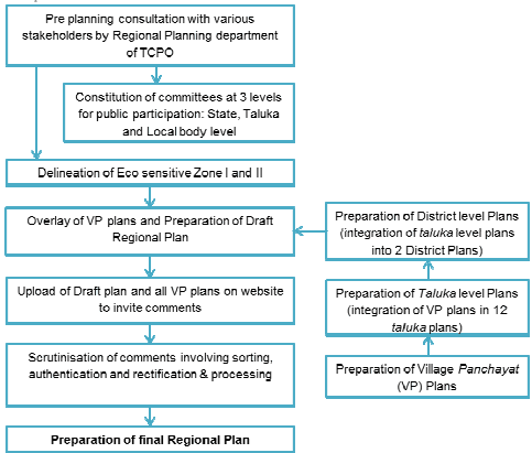
Goa: The State of Goa has prepared Goa Regional Plan, 2021. The basic approach for preparation of Goa Regional Plan has been protection of environmentally sensitive area of the State by introducing “Eco Sensitive Zones” and planning details at village Panchayats level. The Regional Plan gives a micro level planning of the State of Goa with the village Panchayats as the planning units. Multiple level consultative process has been undertaken in preparation of the plan. A decentralised approach was adopted in which a vision document was prepared for the State and was shared with the local bodies/villages. Plans prepared at grass root level were compiled at higher levels to prepare Draft State Regional Plan. Another round of public participation ensured inclusiveness. The approach has been presented in the following diagram.
Figure 4.3: Plan Preparation Process in the State of Goa
Source: Goa Regional Plan, 2021
The States of Kerala and Goa have attempted successfully the preparation of District or Regional plans by adopting 74 th CAA. While Kerala has prepared District plans, Goa has prepared State level Regional plan (but based on the two district plans) due to its size. Both the states have adopted decentralised approach as prescribed in the Constitution of India and have focused on public participation. The approach and methodology of these two States is influenced by the size and settlement structure and hierarchy present in the States.
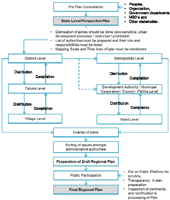
A Planning process at district level for the larger States of India would require much more complex procedure to integrate bottom-up and top down approach. Hence considering the above mentioned case studies and keeping in view the constraints of large size States, a District Regional Planning simplified approach is given in Figure 4.4.
Plan preparation process for regional plan must start with preparation of State level Perspective plan along with pre-plan interactive consultations of government departments, elected representatives, stakeholders, NGOs and Self-help groups. Outcome of such consultations is a Perspective Plan which will be vision document for the entire State either by the State Planning Board, State Town Planning Commission, and State Town & Country Planning Department or by State Urbanisation Committee, such as efforts taken by Kerala and Rajasthan recently.
Perspective Plan must include the LUZs from the State Land Utilisation Policy. In case the State Land Utilisation Policy is not prepared, Perspective Plan should delineate State into developable, prohibited and restricted zones. For this classification, variety of parameters could be used based on development approach of the state. Some of the parameters have been shared below but this is only suggestive list, which must be made exhaustive while preparing plan at state level:
■ Eco sensitive zones of the state,
■ Boundaries of all the urban and rural settlements of the state,
- Mapping of transport and communication networks,
- Mapping of natural features,
■ Industrial, mining and related area,
■ Disaster Zonation
- All maps/plans must be prepared on GIS platform and geo-referenced.
The State Perspective plan should be distributed to the Districts as a reference for preparation of further plans at district level. At the stage of Perspective Plan preparation, the mapping scale, time lines and roles and responsibilities for the preparation of district plan preparation should be decided which will bring clarity and uniformity in mapping and plan preparation process. District administration should proceed with distributing the plans and maps at taluka level and from taluka level to village Panchayats. The Draft Development plan should then be prepared at each village Panchayat level with public participation. Here, capacity building and technical knowhow would need to be percolated from the top administrative set-ups and supporting institutional arrangements. The training to the selected people or people's representatives must be provided along with trained officials through the plan preparation process. Similar process must be followed in settlements of urban hierarchy. Once the plan process at grass root level is over, these plans should be compiled first at taluka level or at its urban counter parts by Development Authority/Municipal Corporation to formulate the draft District Regional Plan.
The Draft District Regional Plan then must be put on public forum for objections and suggestions to impart transparency in the plan process. To meet the purpose of the district plan, interchangeable options and conflict of interest would need to be answered in the regional plan. Once the process of public participation is over and with the approval of State legislature, the final Regional Plan should be uploaded on relevant websites for future reference and use.
Table 4.1Institutional responsibilities
Administrative Unit
Institutional Body
District
DPC/ Zila Parishad
Taluka
Block Development Level/ Town & Country Planning Department
Village Level
Panchayat/ Gram Sabha
Metropolitan & Megapolis
MPC/ Development Authority / Municipal Corporation
Large & Medium Towns
Development Authority / Municipality / Urban Local Body
Small Towns
Nagar Palika/ Municipal Council / State T&CP Department
Ward
Ward Committee
Figure 4.4: Proposed District Planning Process
Source: Compilation from 73 rd and 74 th CAA, State Administrative Setup and Regional Planning examples of Kerala and Goa
4.3.2Various settlements in Region
In delineation of the planning regions there can be certain levels of settlement, existing or planned which give special structure to a region. The growth nodes around which the flows are active and intense shall be the nodal centre. The nodal centre could act as the highest echelon in the hierarchy of the settlements. This may have a unipolar (metropolitan city), bipolar (such as twin cities) or multipolar structure. The other settlements within the region shall be directly or indirectly functionally linked to this centre. They can be:
Counter Magnets: The counter magnets are potential and growing sub nodal centres located out of the direct functionally linked areas of the growth node/ nodal centres in the region, e.g. Hissar, Gwalior, Patiala and Kota etc in context of NCR. The main objective of development of the counter magnets is to prevent undesirable concentration of growth impulses in the nodal centres and to disperse the same to counter magnets for more balanced development of the region. The counter magnet areas may play two distinctive roles:
i. As interceptors of migratory flows into the nodal centre
ii. As regional growth centres, this would be able to achieve a balanced pattern of urbanisation in the region over a period of time.
Satellite Towns: A Satellite Town is one, which is located near or within reasonable distance, well connected by transportation route of the growth node or a metropolitan city, e.g. Gurgaon and Noida (Delhi), Navi Mumbai (Mumbai) and Salt Lake City (Kolkata) etc. The Satellite towns are dependent on the growth node largely for employment. If developed well, satellite towns offer great scope doe providing economic growth and employment for the benefit of the main city, subject to efficient transport connectivity.
Priority Towns: Priority towns are the potential towns for investment and development; identified on the basis of their inter-aerial relationship with the regional nodal centre. For integrated development of the identified region, identification of the priority towns and planning for their development should be done.
Growth Centres/ Points: Settlements with growth potential and special advantage of location within the region can be classified as growth centres/ growth points/ service village in order of hierarchy from high to low while planning for settlement structure within the region.
Peri Urban Areas: Peri-urban areas are zones of transition from rural to urban land uses located between the outer limits of urban and regional centers and the rural environment. The boundaries of peri-urban areas are porous and transitory as urban development extends into rural, agricultural and industrial land. Peri-urban areas might include valuable protected areas, forested hills, preserved woodlands, prime agricultural lands and important wetlands, which may require conservation. Irrespective of how the boundaries move, there will always be peri-urban zones. These areas if planned properly can provide essential life support services for urban residents. In preparation of development plans for metropolitan cities, the area may be taken as 5-8 kms around existing cities, saythose with more than 3 lakh population to cover the urban spill.2
Urban Agglomeration: Census, 2011 defines an urban agglomeration UA) as a continuous urban spread constituting a town and its adjoining outgrowths, or two or more physically contiguous towns together with or without outgrowths of such towns. An UA must consist of at least a statutory town and its total population (i.e. all the constituents put together) should not be less than 20,000. In varying local conditions, there were similar other combinations
2 Working group on urban strategic planning, p 33.
which have been treated as urban agglomerations satisfying the basic condition of contiguity. Examples: Greater Mumbai UA, Delhi UA, etc.
Out Growth: Census 2011, defines ‘Out Growths’ (OG) as a viable unit such as a village or a hamlet or an enumeration block made up of such village or hamlet and clearly identifiable in terms of its boundaries and location. Some of the examples are railway colony, university campus, port area, military camps, etc., which have come up near a statutory town outside its statutory limits but within the revenue limits of a village or villages contiguous to the town. While determining the outgrowth of a town, it has been ensured that it possesses the urban features in terms of infrastructure and amenities such as pucca roads, electricity, taps, drainage system for disposal of waste water etc. educational institutions, post offices, medical facilities, banks etc. and physically contiguous with the core town of the UA. Examples: Central Railway Colony (OG), Triveni Nagar (N.E.C.S.W.) (OG), etc.’
Spatial Priority Urban Regions (SPURs): National Commission on Urbanisation, 1988 with a visionary approach to future urbanisation in India, identified 329 urban centres all over the country as Generators of Economic Momentum (GEMs) where development activities should converge, based on which the upcoming Metropolitan regions could be forecasted. The Commission also identified 49 Spatial Priority Urban Regions (SPURs). SPURs were based on observed trends of growth and Commission's assessment of growth potential, integration with national transport network, optimising investments and opportunities already in a particular region. Such an attempt of regional planning pan India was the first of its kind and evolved from the idea of expanding planned urban regions.