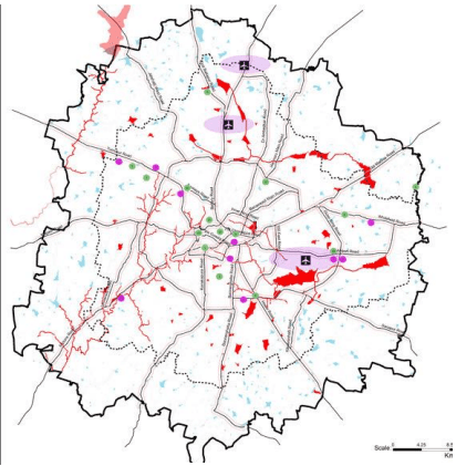
8.4.1 Natural Drainage System
Watershed: Watershed is a geo-hydrological unit of all land and water within the confines of drainage divide which contributes runoff to a common point. It is a land area that captures rainfall and conveys the overland flow and runoff to an outlet in the main flow channel.
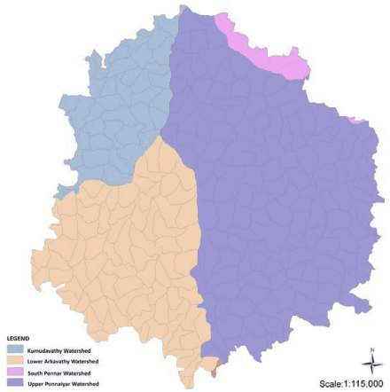
The major drainages in the BUD are the Cauvery and the South Pennar basins19. BMA by its N-S ridge is drained by rivers Arkavathy on the west and South Pennar or South Pinakani River to the east. Arkavathy River is a mountain river originating from Nandi hills which is further north of the BMA boundary and is a tributary of Cauvery River. Arkavathy joins Cauvery River at 34 kms south of Kanakpura outside the boundary of BMA. Additionally, Kumudavathy and Vrishabhavathy rivers are tributaries to the Arkavathy. The two catchments of Arkavathy and Pennar rivers (Figure 8-14) are further divided to four main watersheds in BMA which form separate and distinct drainage zones.
The Arkavathy River in the Arkavathy catchment is a tributary to the Cauvery River and flows in N-S direction. Its drainage pattern is trellis to sub-dendritic and it has high drainage density mainly due to a higher density of first order streams with lesser lengths and is dotted with number of mounds, hills and possesses only small sized tanks to the south west. The Arkavathy catchment is divided into two watersheds, namely,
• the Kumadavathy or upper Arkavathy watershed along the north west of BMA and the
• the Lower Arkavathy watershed along the south west of BMA
The two main tributary systems are flowing from North east to South east direction and the other from east to west and confluence each other at Mysore road. The eastern area of BMA comes under the Upper Pennar watershed and South Pennar watershed. The Figure 8-15 presents the four watersheds in BMA. The lower Arkavathy watershed comprises of the Vrishavabhavathi valley. The Vrishabahavathy River originates at the Bull temple and flows further from the south of BMA where it joins the Cauvery River.
19 The South Pennar river of Ponnaiyar basin takes its birth from Nandi hills and flows towards south.
BAGALOE AUTHORITY ★
Figure 8-14: Two Catchments in BMA
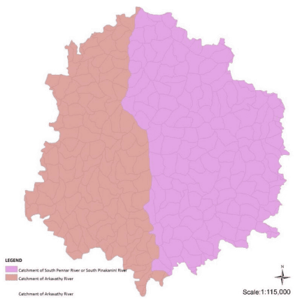
Figure 8-15: Four Major Watersheds in BMA
Source: Karnataka State Remote Sensing Application Centre, GoK, 2015
BANGALOE AUTHORITY ★
Lakes & Valley System: In the eastern part of BMA is the Upper Pennar watershed and South Pennar watershed, there are two major drainages, namely one is from Yelahanka flowing south easterly and the other from Sarakki area. These two watersheds constitutes the Hebbal valley to the north is characterized by first and second order stream, and the Bellandur valley to the south east where the streams passes on to third order. The Bellandur valley system further has the Challaghatta sub valley and Koramangala sub valley. The rainfall in BMA due to its N-S ridge gets divided and flows down to the east or west over the valleys of gentle slopes of Vrishbhavathy, Hebbal and Koramangala & Chalaghatta.
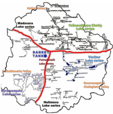
Five minor valleys, the Kathriguppa and Tavarekere to the south, the Arkavathi and Kethamaranahally to the northwest and Marathhally to the east, lie outside the tributary area of the major valleys and they drain independently to the fringe areas. The configurations of valleys in well graded side slopes of their tributary areas have provided Bangalore with a natural system of drainage without resource to pumping. Both sewage and storm water flows by gravity beyond the city. It is noteworthy that each of the valley systems, comprise of system of lake series that are essentially formed by interlinking / cascading lakes or tanks to one another through natural streams/ drains. Figure 8-16 presents the valley system and their respective lake series in BMA. The valley systems and their respective lake series are as following:
a) Hebbal Valley: Yellamappachetty Lake Series and Madvara lake series
b) Koramangala and Challaghatta Valley: Varthur Lake Series, Puttanahalli lake series, Hulimavu Series
c) Vrishbhavathi Valley: Byramangala lake Series
Figure 8-16: Lake Series in the Valleys of BMA
Source: KLCDA
Thippagondanahalli Reservoir: Another important physical feature relevant to the context of natural drainage in BMA is the Thippagondanahalli Reservoir20 (TGR) is located at the confluence of the Arkavathy River and Kumudavathi River, 35 km westwards, outside the BMA boundary. This manmade reservoir built in 1933 has a catchment of 1453 sq.km and covers parts of Doddaballapur, Nelamangala, Devanahalli, Magadi and Bangalore Taluks. The water body used to act as a source of drinking water for western part of Bangalore supplying up to 117MLD, but at present the source has been abandoned due to much decreased inflow to the TGR.
8.4.2 Natural Drainage Classification
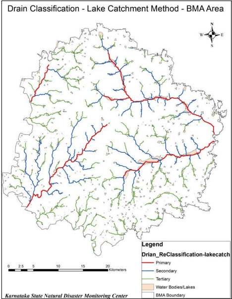
The application of buffers as prescribed by National Green Tribunal is dependent on the classification of streams/ natural drainage, namely – Primary Stream, Secondary Stream and Tertiary Stream. RMP 2031 using the DEM and GIS based software has classified the natural drainage system in consultation with KSNMDC for BMA. Figure 8-17 presents the Drainage Classification for BMA.
Figure 8-17: Drainage Classification
20 Thippagondanahalli Reservoir is also known as T.G.Halli Dam and Chamaraja Sagar.
BANGALOE AUTHORITY ★
The natural drainage so classified was translated to ground situation using Base Map prepared for RMP 2031. The buffers, as prescribed by National Green Tribunal, have been applied to streams/ drainage accordingly for preparation of Proposed Land Use Map.