8.3.1 Forests
The Karnataka Forest Department (KFD) is the state department for forests in Karnataka. The total forest land in Karnataka State is 43,356.47 SqKm 16. The BUD admeasures a geographical area of 2190 SqKm17, out of which areas under forest is 122.26 SqKm Thus, only 5.5% of the BUD is under forests. The percentage of forest comes to only 2.28% of the BMA18. BMA falls under the Bangalore Urban Forest Division of the KFD which has 3 subdivisions, namely, Bangalore North Subdivision, Bangalore South Subdivision and the Lakes Subdivision.
Most of the forests in and around Bangalore now stand degraded due to biotic factors and they are classified as Dry Deciduous Scrub type (DS1). These forests are found at Govindapura, Kadugodi,
Committee 1 of KFD reports 43356.94 sq.km.
17 Annual Report 2013-2014 of Forest Department, Gok and the Reconstituted Expert Committee 1. However, the BUD admeasures a geographical area of 2174.1 sq.km. as per Plan for Bangalore Urban Forest Division 2002-03 to 2011-12; KFD. 8 Existing Land Use 2015
BANGALOE AUTHORITY ★
Mandur, B.M. Kaval, Turaligudda, Jarakabande, Jarakabande Sandal Reserve, Marasandra, Kumbaranahalli, Madappanahalli and Doresanipalya. In most of these places, monoculture plantations of Eucalyptus and Acacia auriculiformes have been raised in the past. However, Bannerughatta National Park/ Forest has different characteristics.
Figure 8-12: Forests Areas within BMA
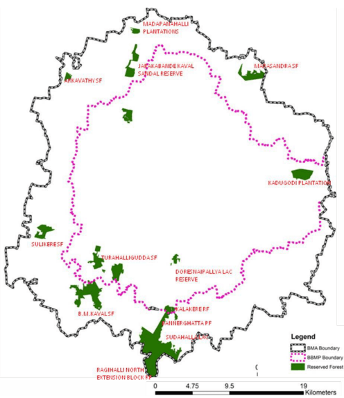
Source: KFD and RMP2031 Analysis, 2015
8.3.2 Eco –Sensitive Zone of Bannerghatta National Park (BNP)
Bannergahatta National Park (BNP) and Bannerghatta Reserve Forest admeasures ~260.51 sq.km. and is spread over BUD and BRD. BNP is the northern tip of this Mysore Elephant Reserve with rich faunal and floral diversity and ~15.89 sq.km. falls within the LPA of BDA and some in the LPA of BMICAPA.
To protect the wildlife, their habitat and its environment, the provisions of Wildlife Protection Act, 1972 and The Environment (Protection) Act, 1986 and the Supreme Court Decision mandates declaration of Eco-Sensitive Zones (ESZ) around the Protected Areas. The Ministry of Environment and Forest, (MoEF) GoI, in year 2007, issued Guidelines for Declaration of Eco-Sensitive Zones National Parks and Wildlife Sanctuaries. The guidelines acknowledge the fact of various existing
developments in the vicinity/ near boundaries of protected areas and has provided the flexibility to define Eco-Sensitive Zones which can extend upto 10km looking into the ground realities.
As per the draft notification issued by the MoEF & CC dated 15.06.2016 states that BNP is an area of high floral and faunal diversity and also an important watershed area through tributaries that join the Cauvery River. Thus, it becomes imperative to protect and conserve the area as an Eco-Sensitive Zone from ecological and environmental view to protect wildlife and their habitat. It states that all activities in the Forest block areas (both within and outside Municipal Areas) shall be governed by the provisions of the Forest (Conservation) Act, 1980 (69 of 1980) and all the activities in the Protected Areas (National Park) shall be governed by the provisions of the Wild life (Protection) Act, 1972 (53 of 1972). Further, buffer extant vary from 100 meter to 4.5kms around the boundary of BNP and is declared as BNP Eco- Sensitive Zone. As per the notification the zone covers 268.96 sq kms. This zone covers 77 villages, 17hamlets and is spread across BUD and BRD. However, the extent of this Eco-sensitive zone within the LPA of BDA and extent of ESZ is such that some of the survey numbers are covered in full, and others are partly falling in the buffer zone. Figure 8-13 depicts the extents and of ESZ of BNP.
Figure 8-13: Extents of Eco-Sensitive zone of Bannerghatta National Park in BMA
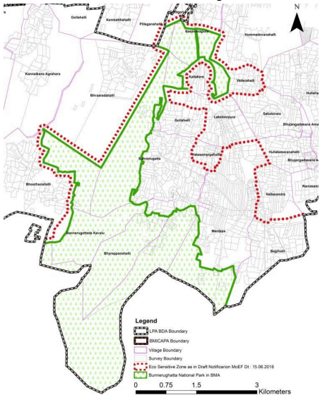
Source: Draft notification MoEF & CC dated 15.06.2016 and RMP 2031
AUTHORITY ★
8.3.3 Historical Trees
KBB has initiated a program to identify certain trees in various districts which are unique, historical and have high significance. The same will be considered for declaring as Heritage Trees. KBB has recommended the following trees within BUD to be declared as Heritage trees under section 63 (2) (i) of the Biological Diversity Act 2002. Table 8-2 presents trees declared as heritage trees by the board.
| S.No | Scientific Name | Location | Girth(m) | Height (m) | Age |
|---|---|---|---|---|---|
| 1 | Ficus Bengalensis (Doddaalada Mara) (Doddaalada Mara) | Kethohalli, in BMA | - | 30 | 400 years |
| 2 | Araucaria cookie | Lalbagh Bangalore | 7 | 50 | 140 years |
Source: Annual Report 2012-13, Karnataka Biodiversity Board
8.3.4 Historical gardens in BMA
Lalbagh botanical gardens and Cubbon Park mark the two major lung spaces of the city. The central and south Bengaluru were structured around these large gardens.
Lal Bagh: Established in 1776 by Hyder Ali and further developed by his son Tippu Sultan, it was initially meant to be a private garden designed in the Moghul style. In terms of area, Lal bagh spreads across 97 Ha. It holds rare plants added by Tippu Sultan in the 18th century from Turkey, Mauratius, Persia and Afghanistan. Some trees over 100 years old still exist. Some of the exotic species introduced from different parts of the world include largest specimen of Kopak tree also called Ceiba pentandra, it is a tropical tree of the order Malvales and the family Malvaceae , native to Mexico, Central America and the Caribbean, northern South America, and to tropical west Africa. Cupressses or Cypress native to scattered localities in mainly warm temperate regions in the Northern Hemisphere, including western North America, Central America, northwest Africa, the Middle East, the Himalayas, southern China and northern Vietnam. It has rare tropical and sub tropic plants like the gymnosperms or early trees which are a group of seed-bearing plants that includes conifers, cycads, Ginkgo and Gnetales. In addition, a number of ornamental and economic plant species both of exotic and indigenous origin can be found in Lalbagh. Take a walk around the lake and you may come across herons, egrets, kingfishers, coppersmiths and even pelicans if you are lucky. These are only some of the close to 50 types of birds which are regular visitors here. Other birds in the city include Common Iora. Yellow-wattled Lapwing,B lack Kite, Ashy Prinia, Large-billed Crow, Green Bee Eater,Rose-ringed Parakeet, Different types of bulbul, Black Ibis, Spotted Dove, White-throated Kingfisher, Pied Bushchat, Black Drongo, Oriental Magpie Robin, Common Hoopoe, Greater Coucal, Red-wattled Lapwing, Plum-headed Parakeet, Asian Koel and Ashy Woodswallow. Also Lal Bagh is the most visited tourist destination in 2014 as per GoK Tourism department statistics.
Cubbon Park: The Cubbon Park has a history of over 100 years. It was established in the year 1870 by Sri John Meade, the then acting Commissioner of Mysore. The vast landscape of the park was conceived by Major General Richard Sankey, the then Chief Engineer of the State. As a mark of honour to Sri John Meade, the park was initially named as "Meade’s Park" and subsequently it was called the Cubbon Park. Since the inception of the park, it was developed and improved by adding new structures and features. In the year 1927, the park was officially renamed as "Sri Chamarajendra Park" to celebrate the Silver Jubilee of Sri Krishnaraja Wodeyar’s rule in Mysore State. Cubbon Park is under the control of the Department of Horticulture. The Deputy Director of Horticulture (Cubbon Park) is responsible for the administration and maintenance of the park. The park has about 68 genera and 96 species with a total of around 6000 plants / trees growing in its locale. The Gulmohar trees and massive clumps of bamboo add a distinct identity to this large lung space.
8.3.5 Conservation Zones along Arkavathi River and Thippagondanahalli Reservoir
Arkavathi River flows from the north west of the BMA to converge at the Thippagonadanahalli (T.G.Halli) Reservoir at the western side of the BMA. As per G.O. No. FEE 215 ENV 2000 dated 18.11.2003, Bangalore. Under Section 18 (I b) of the Prevention and Control of Pollution Act, 1974 and 1981, the GoK declared the catchment area of Thippagondanahalli (T.G. Halli) as a "regulated zone". This means the industries that have come up in the catchment area will not be allowed to let their waste flow into the reservoir. Future development in the catchment area is restricted. BMA falls under the regulation area of Zones 1, 3 and 4. The regulations of Conservations zones along Arakavathi are given in Table 8-3.
| Zones | Area Covered | Nature Of Restrictions/ Regulations |
|---|---|---|
| Zone 1 | Entire Thippagondanahalli Reservoir (TGR) Catchment | • Regulation and checking of over exploitation of ground water. • No fresh licenses for quarrying& stone crushers • No disposition of solid or liquid waste without scientific processing. • Adoption of rain water harvesting (RWH) for existing & new buildings. • Promotion of organic farming including bio-pesticide and biofertilizers |
| Zone 3 | Area covered within 1 km distance | • No person shall carry on activities other |
| from the river banks of Arkavathi | than agricultural or agricultural related | |
| river (only upto Hessargatta tank | activities without prior permission. | |
| from TGR) and Kumudavathi. |
AUTHORITY ★
| Zones | Area Covered | Nature Of Restrictions/ Regulations |
|---|---|---|
| Zone 4 | Area covered within 1 km to 2 km distance from the river banks of Arkavathi river(only upto. Hessargatta tank from TGR) and Kumudavathi (excluding the area within Zone 2) | Permit only those industrial activities which are listed under the Green category by the KSPCB.Adoption of RWH & waste water treatment facilitiesConsent for Establishment to be obtained by KSPCB.Permit G - G+1 new buildings- RWH. |