6.1 General:
The SPA area is divided into various parts, starting from Dighe in the North and up to Dronagiri Fort in the south. The SPA area is well connected to neighboring NMMC and CIDCO areas both by roads and railways network. The proposed Navi Mumbai International Airport is located near the SPA area and JNPT (Jawaharlal Nehru Port Trust), one of the largest container ports in India is located south of Navi Mumbai.
6.2 External communication:
Three major transportation alignments, namely Mumbai Trans Harbour Link (MTHL), Multi-Model Corridor (MMC) and National Highway NH-348 traverse through Part of Pocket B of the SPA area. Other Pockets such as A, C and D are connected through arterial and sub-arterial roads to the neighborhood of the precinct.
6.3 Airways:
The nearest one of the existing Airports is Chhatrapati Shivaji Maharaj International Airport (Domestic and International facilities) which is located about 30-40 km from the SPA area. The proposed Navi Mumbai International Airport is also under construction, which is close to the SPA area. It is hardly located around 5 km from pocket B of SPA. This airport is likely to be completed in 2024 and may be functional in 2025. Navi Mumbai International Airport (NMIA), is the second airport for Mumbai Metropolitan Region (MMR) to be located in Navi Mumbai.
6.4 Railways:
Harbour Railway from CSMT, Mumbai to Panvel and Trans-harbour from Thane to Panvel via CBD Belapur and Thane to Vashi via Sanpada are already passing through Navi Mumbai area and serve as Suburban Railway Services for the benefit of citizens of Navi Mumbai area. In addition to this, a new suburban railway network from Belapur to Uran and Nerul to Uran is also beneficial to the Ulwe and Dronagiri areas of Navi Mumbai.
Pocket A - Dighe, Ilthan, Rabale, Tetavli, Ghansoli, Mahape and Borivali.
Existing Suburban Rail i.e. Trans Harbor link (Thane-Panvel) is around 1 Km from this pocket.
Pocket B - Manghar, Padeghar, Vahal, Jasai and Chirle.
The dedicated Freight Corridor (DFC) being developed by DFCC passes adjacent to the above pockets eventually connecting to JNPT.

<details> <summary>seal</summary>
司 CO a </details>
Pocket C - Chanje, Nagaon and Mhativali.
Uran Railway station is located approximately 2 Km from this pocket. There is no direct connectivity via the railway network to this pocket.
CIDCO has also started a Metro rail from CBD Belapur to Pendhar (Near Taloja) which is part of Navi Mumbai
6.5 Roadways (External):
The SPA areas area is near external roadways such as Thane – Belapur State Highway, MTHL, NH-48 (Mumbai- Bangalore), Mumbai – Pune Expressway via Vashi and NH 348 (Palaspe to JNPT) which connects to parts of other cities.
6.6 Waterways:
Integration with Regional Transport Network: The airport and the Sea Port (JNPT) are the two traffic-generating centers with national significance. The regional connectivity therefore becomes a major consideration in planning transport infrastructure predominantly at Pocket C. Accordingly the regional, interstate and national level of roads have been considered and incorporated in the proposed transport network.
6.7 Roads (Internal):
Pocket A Dighe, Ilthan, Rabale, Tetavli, Ghansoli, Mahape and Borivali. Thane-Belapur road is around 1 km from these pockets of the SPA area. Mulund Airoli Road is around 1.5 Km from Rabale Pocket of the SPA area. Pocket Ghansoli has direct access to MIDC-Mahape Road. MIDC-Mahape Road and Shil Phata Mahape Road is approx. 800 mt from Mahape Pocket.
❖ Thane-Belapur road
◆ Mulund Airoli Road
◆ MIDC-Mahape Road
❖ Shil Phata Mahape Road
Figure 16 - Roads at Pocket Dighe, Ilthan, Rabale, Tetavli, Ghansoli, Mahape
Pocket B Manghar, Padeghar, Vahal, Jasai and Chirle.
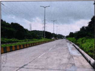
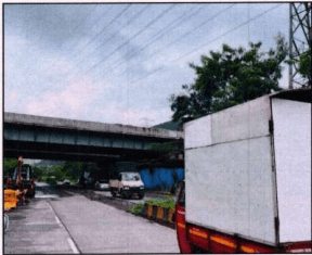
The existing JNPT road (NH-348) is passing through Pocket Padeghar and SH-54 is around 0.5 Km distance from Pocket Padeghar. There is a cloverleaf interchange (Gavhanphata) at Pocket B Vahal between Amra Marg and JNPT Road (SH-348). SH-104 is passing through Pocket Vahal and Chirle. Pocket Jasai has direct access from NH-348.
Existing Roads
◆ NH-348 – JNPT Road
✿ NH-348A – Amra Marg
✿ SH-104 – Gavhanphata-Chirner Road
✿ SH-54 - Uran Panvel Road
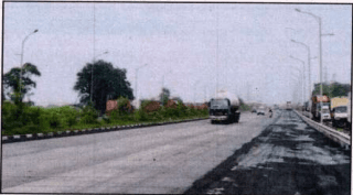
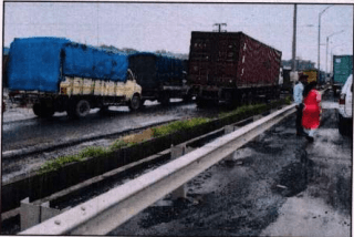
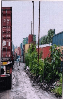
Figure 17-Roads at Pocket Manghar, Padeghar, Vahal, Jasai and Chirle
6.8 Existing Road:
Pocket C - Uran Panvel Road (SH-54) is around 1 Km from this pocket. No direct road connectivity to this pocket because of hilly terrain. Hill observed on site is known as Dronagiri Hill.
Pocket D - which is Karave island has an access of existing bund connected with palm beach road.

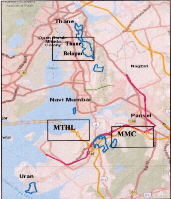
Figure 18- Existing Road Network in Navi Mumbai Region
6.9 Bus and passenger traffic:
City bus service, at present, is run by NMMT in some portions of SPA areas. The State Transport (ST) buses are also passing through the SPA area and its bus stops (pickup and drop-up services) are located in various locations. However, ST buses originate from Dadar, Thane, Uran and Panvel.
6.10 Parking Facility:
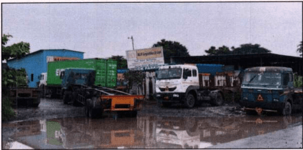
There are no formal public parking spaces in the SPA area. Privately owned/maintained Container/truck parking facilities are available in Padeghar and Vahal villages.
Figure 19 - Truck Parking Facility at Village Padeghar