Section 1 Planning Approach
The basic approaches to planning for the new town planning area are as follows:
Integrated development of the total area catering to the high demand of lands in this area and its surroundings
Plan attempts to encourage a diverse economic base with an intention to achieve social equity for promoting the distribution of economic benefits among all sections of people in this area
Balanced and eco‐efficient development without putting much stress on the natural resources
Adequate green zones have been provided so as to minimise the effect of pollution in the residential and other public activity areas
Improved state‐of‐the‐art infrastructure facilities (transportation, water supply, drainage, solid waste disposal, sanitation, telecommunication, etc.) Along with social amenities (health, education, culture and recreation) within an ecologically sustainable framework
Section 2: Population Projection
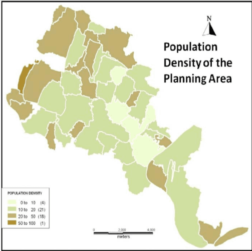
The planning area is moderately populated. Present day scenario shows a lot of real estate investments in the villages here due to the development of Rajarhat New Town Area with all Services.
| District With Police Station | Sl No | Name Of The Mouza | J.L. No | Total Population |
| North 24 Parganas , Rajarhat | 1. | Raigachi | 12 | 163 |
| North 24 Parganas , Rajarhat | 2. | Recjuani | 13 | 13,298 |
| North 24 Parganas , Rajarhat | 3. | Tarulia | 21 | 2,973 |
| North 24 Parganas , Rajarhat | 4. | Sulangari | 22 | 1,918 |
| North 24 Parganas , Rajarhat | 5. | Ghuni | 23 | 15,381 |
| North 24 Parganas , Rajarhat | 6. | Jatragachhi | 24 | 5,118 |
| North 24 Parganas , Rajarhat | 7. | Kadampukur | 25 | 1981 |
| North 24 Parganas , Rajarhat | 8. | Chakpachuria | 33 | 5024 |
| North 24 Parganas , Rajarhat | 9. | Baligari | 34 | 4193 |
| North 24 Parganas , Rajarhat | 10. | Chhapna | 35 | 2519 |
| North 24 Parganas , Rajarhat | 11. | Patharghata | 36 | 8039 |
| North 24 Parganas , Rajarhat | 12. | Akandakeshari | 55 | 2847 |
| North 24 Parganas , Rajarhat | 13. | Mahisgot | 20 | 7224 |
| North 24 Parganas , Rajarhat | 14. | Thakdari | 19 | 4247 |
| North 24 Parganas , Rajarhat | 15. | Chandiberia | 15 | 293 |
| North 24 Parganas , Rajarhat | 16. | Jagadishpur | 27 | 3584 |
| North 24 Parganas , Rajarhat | 17. | Dharsa Moktarpur | 26 | 2566 |
| North 24 Parganas , Rajarhat | 18. | Mahammadpur | 32 | 4141 |
| North 24 Parganas , Rajarhat | 19. | Bhatenda | 28 | 4,513 |
| North 24 Parganas , Rajarhat | 20. | Khamar | 29 | 827 |
| North 24 Parganas , Rajarhat | 21. | Bishnupur | 44 | 10,293 |
| North 24 Parganas , Rajarhat | 22. | Kalaberia | 30 | 1794 |
| North 24 Parganas , Rajarhat | 23. | Basina | 31 | 4,250 |
| North 24 Parganas , Rajarhat | 24. | Chota Chanpur | 43 | 1820 |
| North 24 Parganas , Rajarhat | 25. | Jamalpara | 42 | 2,415 |
| North 24 Parganas , Rajarhat | 26. | Umarhati | 41 | 779 |
| North 24 Parganas , Rajarhat | 27. | Kalikapur | 40 | 1666 |
| North 24 Parganas , Rajarhat | 28. | Kashinthpur | 39 | 2166 |
| North 24 Parganas , Rajarhat | 29. | Sikharpur | 49 | 3,760 |
| North 24 Parganas , Rajarhat | 30. | Jhalgachhi | 38 | 1,367 |
| North 24 Parganas , Rajarhat | 31. | Ganragari | 37 | 1907 |
| North 24 Parganas , Rajarhat | 32. | Nawabad | 53 | 4975 |
| North 24 Parganas , Rajarhat | 33. | Hudarait | 54 | 2369 |
| South 24 Parganas , Kolkata Leather Complex | 34. | Koch Pukur | 2 | 1,961 |
| South 24 Parganas , Kolkata Leather Complex | 35. | Jot Bhim | 3 | 1859 |
| South 24 Parganas , Kolkata Leather Complex | 36. | Hatisala | 9 | 3810 |
| South24 Parganas , Kashipur | 37. | Tara Hadia | 13 | 1,211 |
| South24 Parganas , Kashipur | 38. | Dakshin Khayerpur | 12 | 657 |
| South24 Parganas , Kashipur | 39. | Abua | 11 | 1766 |
| South24 Parganas , Kashipur | 40. | Pitha Pukuria | 24 | 11078 |
| District With Police Station | Sl No | Name Of The Mouza | J.L. No | Total Population |
| 41. | Jiran Gachhi | 25 | 5193 | |
| 42. | Bamunia | 45 | 15582 | |
| 43. | Chalta Beria | 69 | 4167 | |
| 44. | Chak Maricha | 71 | 3990 | |
| 45. | Bhaga Banpur | 10 | 3376 | |
| TOTAL AREA | TOTAL AREA | TOTAL AREA | TOTAL AREA | 185060 |
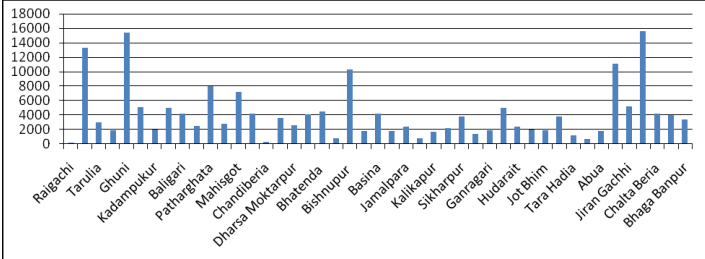
NB: the population of NTPA accounts for 3.19% of North 24 Parganas and 0.93% of South 24 Parganas Rural Poulation. Growrh rate of rural population West Bengal is 7.73 per cent since 2001
Section 3 General Proposal and Proposed Land use Categories
The planning area has been planned in a way so as to be a continuity of the New Town area as well as being an entity in itself of self contained zones.
For the purpose of formulating the general proposals for the Land Use & Development Control Plan, the entire area covered under this LUDCP has been divided into seven Land Uses Zone Categories as stated below.
1 Land Use Zone Category – I: Predominantly Residential
Of the total planning area, mouzas in the northern part namely Raigachhi J.L. No. 12, Rekjuani J.L. No. 13, Bhatenda J.L. No. 28, Basina J.L. No. 31 and Sulanguri J.L. No. 22 in the east have high density of existing residential areas. Hence major residential areas have been planned in all the above mentioned mouzas. In addition, residential zones have also been provided in Bishnupur J.L. No. 44, Chhoto Candpur J.L. No. 43, Jamalpara J.L. No. 42, Kalikapur J.L. No. 40, Kashinathpur J.L. No. 39, Jhalgachhi J.L. No. 38 & Naobad J.L. No. 53 have also been primarily reserved as residential zones in majority of the areas. Another major chunk of residential zone has been reserved in parts of Pithapukria Mouza J.L. No. 24 at the crossing of Bagjola Canal & Bidyadhari Khal so as to provide residential areas for industrial areas planned at the southern side of the Bagjola Canal of the Planning Area.
The land under this category comprises the areas that are to be used predominantly for buildings of residential use. The land under this category will be used for Collector & Local Streets as well as Community Facilities, open
spaces and Utilities. Mixing of other permissible uses will allowed as specifies in Chapter – V of this LUDCP.
2 Land use Zone Category – II: Predominantly Business & Mercantile (Retail)
The Planning area has been provided with a CBD in a place where the road network converges at Umarhati Mouza J.L. No. 41. Business and Merchantile (Retail) Zones have thus been planned in areas where maximum free land is available for quick development like parts of Jamalpara Mouza J.L. No. 42, Kashinathpur Mouza J.L. No. 39, Bishnupur Mouza J.L. No. 44 and Sikharpur Mouza J.L. No. 49. Commercial zones have also been provided in parts of Bhagabanpur Mouza J.L. No. 10, and Pithapukria J.L. No. 24 to cater to the surrounding compatible areas.
The land under this category comprises of the areas that are to be used predominantly for buildings of Business & Mercantile (retail) Use. The land under this category will be used for Collector & Local Streets as well as Community Facilities and Utilities. Mixing of other permissible uses will be as specifies in Chapter – V of this LUDCP.
3 Land use Zone Category – III: Predominantly IT and ITES
IT & ITES Zones have been provided in sync with such areas in New Town Area. Two major areas of IT Development have thus been provided in Jagadishpur Mouza J.L. No. 27, Gangragari J.L. No. 37, Hudaitpur J.L. No. 54 & Naobad J.L. No. 53.
The land under this category comprises the areas that are to be used predominantly for buildings of IT and ITES uses. The land under this category will be used also for Collector & Local Streets as well as Community Facilities and Utilities. Mixing of other permissible uses will be as specifies in Chapter – V of this LUDCP.
4 Land use Zone Category – IV: Predominantly Educational, Assembly, Institutional and Health Facility
Major portions of Dakshin Khairpur Mouza J.L. No. 12, Hudarait J.L. No. 54, Bhagabanpur J.L. No. 10, Portions of Abua J.L. No. 11, Tarahadia J.L. No. 13 have been reserved as Educational, institutional zones and a major chunk of area of Pithapukria Mouza J.L. No. 24 has been reserved for health facilities like multi‐speciality hospitals and other state of the art health infrastructure.
The land under this category comprises the areas that are to be used predominantly for Educational, Assembly Institutional and health facility. The land under this category will be used also for Collector & Local Streets as well as Community Facilities and Utilities. Mixing of other permissible uses will be as specifies in Chapter – V of this LUDCP.
5 Land use Zone Category –V: Predominantly Industrial Use comprising on Small scale Industrial area & Agro based Industrial Area
Since the entire planning area has a lot of agricultural lands in the southern part in mouzas to the south of the Bagjola Canal, areas have been earmarked for Agro Processing Industries and other Small Scale Industrial Areas in the southern part of the Planning Area in parts of Jirangachhi J.L. No. 25, Bamunia J.L. No. 45, Chaltaberia J.L. No. 69 and Chakmaricha Mouza J.L. No. 71. This has been reserved keeping in mind the easy access of industrial traffic through Bansanti Highway to the south of the Planning Area and close proximity to Bantola and other areas.
The land under this category comprises the areas that are to be used predominantly for Industrial uses comprising of Small scale industrial Area & Agro based Industrial area. Construction of buildings and Structures
are not permitted excepting those required for operation, maintenance, development or execution of these roads.
6 Land use Zone Category –VI: Predominantly Major Roads comprising Major Arterial Roads, Arterial Road, Sub Arterial Roads and Logistics Hub
The major road network has been designed in a way following the pattern of the New Town area and taking into consideration major existing roads of the erstwhile BRADA region like the Lauhati Road, Rajarhat Main Road, SRMC Road, and Bishnupur Road. The road network has thus been designed in a concentric manner, development zones have been reserved on the Western side of the Lauhati Road and a green buffer has been kept beyond the Lauhati Road on the east so as to control haphazard development in areas beyond the planning area boundary. Roads have also been extended from the New Town road network so as to provide a smooth linkage between both these areas. The overall transport network has thus been planned maintaining the regional connectivity to all surrounding areas. The expressway has also been retained while planning to pass through the planning area, however, development has not been aligned according to it as this expressway will act as a bypass for major traffics on an elevated level.
The land under this category comprises the areas that are to be used predominantly for building of Major Roads comprising Major Arterial Roads, Arterial Roads Sub Arterial Roads and Logistic Hub or Transport terminal. Construction of buildings and Structures are not permitted excepting those required for operation, maintenance, development or execution of these roads.
7 Land use Zone Category – VII: Predominantly Open Spaces, Water Bodies & Green Areas
Major Water Bodies have been preserved in the Planning Area and adequate green areas have been planned for. Each land use sector has ample amount of green and open spaces that have been reserved to maintain a sustainable balance. The eastern side of the Lauhati Road has been primarily kept as green areas to act as buffer to control the spillover urbanization in the neighbouring villages of the Planning Area.
The land under this category comprises the areas that are to be used predominantly for parks, play ground, green areas and water bodies. Construction of buildings and structures are not permitted excepting those specified in Development Control Regulation referred in Chapter – V of this LUDCP.
8 Land use Zone Category – VIII: Predominantly Utilities & Services
Due to the location of industrial sectors in the southern zone of the planning area and also the proximity of the Basanti Highway a Garbage Disposal Ground has been earmarked to cater to the entire planning area at the Bhangar Road – Chowrishwar Canal junction in Bamunia Mouza J.L. No. 45. Other utility zones have been provided in all major landuse sectors to cater to all utility and service needs of the planning area.
The land under this category comprises the areas that are to be used predominantly for Residential Utility and services that include major infrastructure for water supply, sewerage, drainage, Solid Waste Management & Power Supply. Construction of Buildings and structures to be used exclusively for the operation maintenance, development or execution of these essential utilities & services shall be considered as ‘Operational’ and shall be outside the purview of this LUDCP.
Section 4 Proposed Land use Map
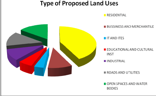
This LUDCP indicates broadly the manner in which the land is proposed to be used. It also allocates areas of Land Use Zones of different categories as per the proposed Land Use Map NO 2 of the LUDCP.
| Type of land uses | In sqkm | % of use |
|---|---|---|
| RESIDENTIAL | 26.782 | 29 |
| BUSSINESS AND MERCHANTILE | 6.012 | 6 |
| IT AND ITES | 2.353 | 2 |
| EDUCATIONAL AND CULTURAL INST | 3.618 | 4 |
| INDUSTRIAL | 6.317 | 7 |
| ROADS AND UTILITIES | 8.496 | 9 |
| OPEN SPACES AND WATER BODIES | 9.425 | 10 |
NB:
• For conversion to Educational and Cultural Institution and Bussiness and Merchantile assumed to be Commercial use.
For conversion to IT and ITES and Industrial assumed to be Industrial use if that related to manufacturing otherwise will be treated as commercial.
• No permission for conversion in any form would be allowed at proposed Open Spaces and Water Bodies, Roads and Utilities
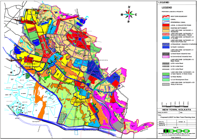
MAP 6 Proposed Land Use Map including Master Land Use plan of the New Town Planning Area (part)