Section 1 Area Profile
The concerned planning area belongs to two districts of West Bengal, namely North 24 Parganas and South 24 Parganas. It consists of the two different parts; one is to the eastern part of the township area and covers the area approx 45 sq km and other part is some pockets, to west of township area which is approx 15 sq km.
The North Eastern boundary of the NTPA is Nowai Canal, Langalpota, Mobarakpur, Chandpur Champnagachi, Arbelia, Swastayangachi, Bidyadhari Canal, Satuliya, Kachau Bazar, Shaan Pukur and Bhangar and the Southen part of the boundary of NTPA is Maricha Gram, Bhojerhat and the Western part is Chowreswar Canal , Bagjola Canal and existing planning area of New town Rajarhat up to eastern boundary.
The TOWNSHIP covers two districts of West Bengal,
a) North 24 Parganas and
b) South 24 Parganas.
| District With Police Station | Sl No | Name Of The Mouza | J.L. No | Area In Sqkm |
| North 24 Parganas , Rajarhat | 1. | Raigachi | 12 | 1.37 |
| North 24 Parganas , Rajarhat | 2. | Recjuani | 13 | 1.71 |
| North 24 Parganas , Rajarhat | 3. | Tarulia | 21 | 0.204 |
| North 24 Parganas , Rajarhat | 4. | Sulangari | 22 | 0.96 |
| North 24 Parganas , Rajarhat | 5. | Ghuni | 23 | 1.857 |
| North 24 Parganas , Rajarhat | 6. | Jatragachhi | 24 | 0.65 |
| North 24 Parganas , Rajarhat | 7. | Kadampukur | 25 | 0.5 |
| North 24 Parganas , Rajarhat | 8. | Chakpachuria | 33 | 0.799 |
| North 24 Parganas , Rajarhat | 9. | Baligari | 34 | 0.667 |
| North 24 Parganas , Rajarhat | 10. | Chhapna | 35 | 0.45 |
| North 24 Parganas , Rajarhat | 11. | Patharghata | 36 | 1.509 |
| North 24 Parganas , Rajarhat | 12. | Akandakeshari | 55 | 1.206 |
| North 24 Parganas , Rajarhat | 13. | Mahisgot | 20 | 0.282 |
| North 24 Parganas , Rajarhat | 14. | Thakdari | 19 | 0.74 |
| North 24 Parganas , Rajarhat | 15. | Chandiberia | 15 | 0.47 |
| North 24 Parganas , Rajarhat | 16. | Jagadishpur | 27 | 1.72 |
| North 24 Parganas , Rajarhat | 17. | Dharsa Moktarpur | 26 | 0.7 |
| North 24 Parganas , Rajarhat | 18. | Mahammadpur | 32 | 1.48 |
| North 24 Parganas , Rajarhat | 19. | Bhatenda | 28 | 1.08 |
| North 24 Parganas , Rajarhat | 20. | Khamar | 29 | 0.62 |
| North 24 Parganas , Rajarhat | 21. | Bishnupur | 44 | 1.26 |
| North 24 Parganas , Rajarhat | 22. | Kalaberia | 30 | 0.613 |
| District With Police Station | Sl No | Name Of The Mouza | J.L. No | Area In Sqkm |
| 23. | Basina | 31 | 1.29 | |
| 24. | Chota Chanpur | 43 | 0.635 | |
| North 24 Parganas , Rajarhat | 25. | Jamalpara | 42 | 1.72 |
| North 24 Parganas , Rajarhat | 26. | Umarhati | 41 | 0.8 |
| North 24 Parganas , Rajarhat | 27. | Kalikapur | 40 | 1.32 |
| North 24 Parganas , Rajarhat | 28. | Kashinthpur | 39 | 1.54 |
| North 24 Parganas , Rajarhat | 29. | Sikharpur | 49 | 2.16 |
| North 24 Parganas , Rajarhat | 30. | Jhalgachhi | 38 | 0.54 |
| North 24 Parganas , Rajarhat | 31. | Ganragari | 37 | 1.58 |
| North 24 Parganas , Rajarhat | 32. | Nawabad | 53 | 2.08 |
| North 24 Parganas , Rajarhat | 33. | Hudarait | 54 | 2.08 |
| South 24 Parganas , Kolkata Leather Complex | 34. | Koch Pukur | 2 | 0.75 |
| South 24 Parganas , Kolkata Leather Complex | 35. | Jot Bhim | 3 | 0.93 |
| South 24 Parganas , Kolkata Leather Complex | 36. | Hatisala | 9 | 0.812 |
| South24 Parganas , Kashipur | 37. | Tara Hadia | 13 | 0.69 |
| South24 Parganas , Kashipur | 38. | Dakshin Khayerpur | 12 | 0.48 |
| South24 Parganas , Kashipur | 39. | Abua | 11 | 0.58 |
| South24 Parganas , Kashipur | 40. | Pitha Pukuria | 24 | 4.78 |
| South24 Parganas , Kashipur | 41. | Jiran Gachhi | 25 | 1.66 |
| South24 Parganas , Kashipur | 42. | Bamunia | 45 | 7.69 |
| South24 Parganas , Kashipur | 43. | Chalta Beria | 69 | 1.53 |
| South24 Parganas , Kashipur | 44. | Chak Maricha | 71 | 1.29 |
| South24 Parganas , Kashipur | 45. | Bhaga Banpur | 10 | 2.57 |
| TOTAL AREA | TOTAL AREA | TOTAL AREA | TOTAL AREA | 60.354 |
Section 2: Present Land Use of New Town Planning Area
The present land use map has been prepared from physical survey map through DGPS system. Existing areas in this zone mainly comprises of agricultural lands. There are vacant lands and garden areas also present surrounding existing settlement blocks. The area is moderately flat land. The slight ground slopes are mainly towards the central portion and towards internal and natural drainage channels.
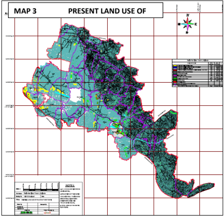
| 1. LANDUSE ZONE I - RESIDENTIAL 13.28 sq.km 21.06% |
| 2. LANDUSE ZONE II - BUSINESS AND MERCAN 0.18 sq.km 0.29% |
| 3. LANDUSE ZONE III - IT AND ITES 0.00 sq.km 0.00% |
| 4. LANDUSE ZONE IV - Educational, Institutional, Cultural 0.93 sq.km 1.50% |
| 5. LANDUSE ZONE V - ROAD&TRANSPORTATION 4.05 sq.km 6.40% |
| 6. WATER BODY/CANAL 3.19 sq.km 6.60% |
| 7. INDUSTRIAL AREA 0.38 sq.km 0.63% |
| 8. VACANT LAND / OPEN SPACE 3.10 sq.km 5.15% |
| 9. AGRICULTURAL AREA 29.77 sq.km 49.30% |
| 10. RECREATION 5.47 sq.km 9.07% |
| Total Area 60.35 Sq km. |
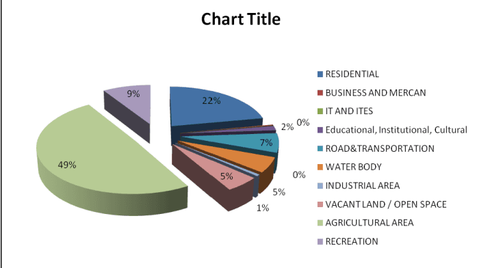
Fig 3 Graphical Representation of Present land use break up
Section 3 Relationship with Neighbouring Areas
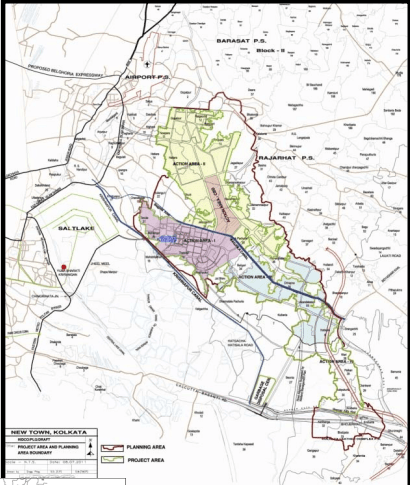
The major area or location of habitation from Northern side is Raigachi which is situated near at Rajarhat Reck Joyani More, this is the biggest populated or habited area of extreme northern side of our project area. After that one of the populated and commercial places is Rajarhat Station More.
In the planning area we have found some Major Canals which are very important not for only Project area, but for adjoining area also and those canals are major drainage system of Kolkata, North 24 Parganas and South 24 Parganas. Not only drainage system, those canals are very important for irrigation also, one of the important reasons of good numbers of agriculture is enough supply of water from those canals.
MAP 4 Location of New Town with respect to salt lake and other Neighbourhoods
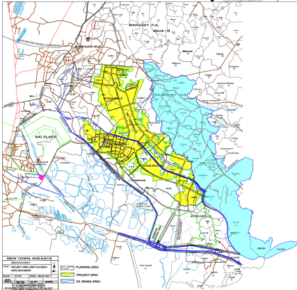
MAP 5 Location of New Town Planning Area indicating erstwhile BRADA in Blue Colour
One of the most important canals of our project area is Krishnapore Canal. This extends extreme south west part of our project area and also New town area. Another Important and Major canal is Noai Canal which extends at extreme North east side of project area and this canal also one side boundary of our project area. Bidhyadhari Canal takes a major role for the Drainage and Irrigation system of North 24 Parganas and Kolkata town. Bagjola Canal is an important canal of the Project area both for New Town area and the New Town Planning Area.
west part of NTPA,forming the Boundary.In this LUDCP, careful planning attention has been paid to
Chowreswar Canal extends on South
water bodies so as to make an eco‐friendly design for the Planning Area. Existing settlements are included in planning the New Town Planning Area where basic infrastructure services are needed.
Section 4 Development Policy of Different Land Uses of New Town Planning Area
The New Town Planning Area has been planned to grow as an organic city producing a composite fabric of different uses that are needed for people of various categories of different income groups to live, work and invest in within an efficient, attractive and healthy environment. The conventional land use planning practice of creating separate zones for exclusive use has not been encouraged. Instead, efforts have been made through careful planning to promote a development pattern that will encourage environmentally acceptable mixed uses in a selective manner for ensuring efficiency, comfort, attractiveness and economy. However, for convenience and clarity of presentation, the major uses are discussed below in terms of each category of use areas.
Residential Areas
The residential areas will consist of groups of residential clusters (i.e. group housing and individual plots) in which different sections of people of different income levels can live harmoniously without being fragmented from the whole community. Neighbourhood units will be used as planning modules of residential growth but their sizes and forms would vary depending on various considerations.
The residential sectors will be provided with adequate social and community facilities which include:
Educational facilities: nursery, primary and secondary schools
Health facilities including speciality hospitals
Markets as well as local level convenient shopping and neighbourhood shopping facilities
Post & Telegraph offices
Police stations
Cultural centres and community halls including library, gymnasium, auditorium, etc.
Parks and organized open spaces of different sizes, to be used as tot lots, children’s parks, neighbourhood parks, playgrounds, etc.
In the residential areas, service industries that are compatible with residential settlements and are non‐hazardous, non‐polluting and non‐offensive in nature may be allowed.
New Business District And Other Commercial Areas
As already mentioned, NTPA will provide a central business district to act as a supplementary CBD of the township of New Town Rajrhat. The new Central Business District is proposed to be located along the major arterial roads. Four other commercial zones will be developed as commercial subcentres of the new town planning area. The major facilities to be provided in these centres will include:
Office complex. Both for the public and private sector
Head quarters and / or regional offices of banks, insurance companies, financial institutions, etc.
Major offices of the airlines organizations
Hotel complex
16
Shopping complex