2.1 National and Regional Settings:
The NMMC is lying between 1 9 ° 0 0 ′ to 1 9 ° 1 2 ′ North Latitude and 7 2 ° 5 8 ′ to 7 3 ° 0 3 ′ East Longitude with 3.25 meters mean height above sea level. NMMC is situated along Mumbai-Pune highway and a fast developing area and has tremendous development potential due to development of Navi Mumbai as Twin City, upcoming International Airport in the vicinity of Navi Mumbai area, Development of proposed Nhava-Sheva link road, proposed water transport services along the coastal area touching NMMC, existing Mumbai-Pune express highway which start from eastern boundary of NMMC. The NMMC is closed to Greater Mumbai & developed as new town by CIDCO where most of the population migrated from Mumbai & surroundings is residing in Navi Mumbai. In addition to above, Metro, railway from CBD Belapur to Pendhar has been taken up by CIDCO. Trans harbor railway from Nerul/Belapur to Uran in also being implemented by CIDCO, which is link up with existing Trans Harbor/ Harbor Railway. JNPT is also located nearby Navi Mumbai where bulk cargo facility is available.
There are seven nodes under NMMC namely Belapur, Nerul, Sanpada, Vashi, Koparkhairane, Ghansoli, Airoli and eight administrative wards e.i. Belapur, Nerul, Turbhe, Vashi, Koparkhairane, Ghansoli, Airoli& Digha.
Source : ESR 2017-2018.
2.2 Physiography:
Physiographically, Navi Mumbai region can be divided into three divisions, viz.(i) The Upland, (ii) The level land plains and (iii) The coastal zone (The low lying areas).
(i) The Upland: It covers Parsik hills with peaks rising from 200 to 250 meters, above MSL lies in the north-eastern part of the study area.
(ii) The Level Land (Plains): Plain land is found in the eastern, southern and northern part of the Navi Mumbai. Northern part of Navi Mumbai, it lies between low lying areas in the west and hills in the east, which covers the major industrial region of Thane-Belapur industrial belt.
(iii)The Coastal Zone (The low lying areas): The western part of the Navi Mumbai
region is a coastal region, covers western parts of Airoli, Ghansoli, Khoparkhairane, Vashi, Sanpada, Nerul southern parts of Belapur node.
According to CRZ Notification dated 19th February, 1991, first CZMP was prepaid & sanctioned by MoEF on 8th September, 1996 which was further revalidated till 31st July, 2018. The said Notification 1991 was further amended by MoEF on 6th January, 2011. And accordingly, Draft CMZP plans, as per Notification 6th January, 2011 was published by MoEF on 7th May 2018. The said Draft CZMP is not yet finalized by MoEF.
According to the draft CRZMP (revised)published under CRZ Notification dated 6th January, 2011 the coastal stretches of Navi Mumbai are divided into following three zones.
+ CRZ I-This is essentially an area between the low tide line and high tide line which is environmentally sensitive zone. This CRZ I area covers 18.67Sq. kms. In Navi Mumbai which include mangroves.
CRZ II- This is coastal area within 500 meter buffer zone from sea and 100 meter or equal to the width of the creeks whichever is lesser that is already developed. The development is permissible in the zone only on land ward side of the existing road or structure , provided the land use and FSI remains same as permissible as on 19th February 1991. CRZ II covers 6.45 Sq. kms. Of area in Navi Mumbai.
CRZ III- It includes areas that are relatively undisturbed and those do not belong to either CRZ I or CRZ II which include coastal zone in the rural areas (developed and undeveloped) and also areas within Municipal limits which are not substantially built. Within CRZ III area up to 200 meter from the HTL on the land ward side in case of sea front and 100 meter along tidal influenced water bodies or width of the creek whichever is less is earmarked as “No development zone”. CRZ III covers 0 Sq. kms. Area in Navi Mumbai.
The total area covered under NMMC is 109.59 sq. km. out of which 25.12sq. km area is affected by CRZ Notification. The break-up of areas covered under Draft CZMP 2011 is as under:
| (%) compared to total CRZ CRZ Category/ Zone Area under CRZ (Sq. km) area | ||
| CRZ I | 18.67 | 74.32% |
| CRZ II | 6.45 | 25.67 % |
| CRZ III | - | - |
[Source : CRZ Notification & Net Information.]
By supersession of said CRZ Notification 2011, new CRZ Notification 2019 has also been issued by MoEF on 18thJanuary, 2019. Under this new CRZ Notification 2019, the NDZ in CRZ-III area is reduced from 200 meter to 50/200meter depending upon the population density. Even CRZ-II area along the creeks is also reduced to 50 m. instead of 100 m. According to this CRZ Notification2019, revised CZMP needs to be prepared afresh & to be sanctioned by MoEF. Till then, earlier CZMP 2011 will be operative& needs to be taken into consideration while considering the proposal as per this notification dated 18th January, 2019.Therefore, the details, as per CRZ Notification 2019, is not worked out.
2.3 Minerals:
Mineral is a natural inorganic substance which possesses a definite chemical composition and definite physical and chemical properties. Presence of minerals plays an important role in the development of a region or a country.
Navi Mumbai lacks in respect of mineral resources endowment. Trap rocks being hard, dense and durable are most suitable for building purposes, but generally lack in minerals. Saltpans, due to rapid urbanization, are lying vacant, along the coast. Sand mining takes place in the areas like Belapur Creek, Thane Creek of Navi Mumbai. Source : Net Information.
2.4 Soils:
In general, soil refers to the loose surface of the earth as distinguished from soil rocks. Soils a natural body consisting of mineral matter, decaying organic matters and micro-organisms. It is a living body and reacts in different manner depending on different climatic factors. Soil is one of the predominant natural resources of nature, which gives
bread and butter to mankind for survival. There is a relationship between soil and vegetation, between soil and climate, between climate and vegetation, between soil and parent rock, between soil and slope, and even climate and slope all these factors co-operate in the production of the actual soil.8 No life without soil and no soil without life, they have evolved together.
Soil forms one of the important natural resources of any region. These support the variety of terrestrial life. Soil is effectively a non-renewable resource. The coastal saline soils occur in the area due to periodical inundation of cultivable land by creek/ seawater during high tides. Such periodical inundations render otherwise fertile soil progressively saline and in time make it completely unfit for growing any crop. Even when putting an embankment checks the encroachment of saline creek water, the blackish water from shallow water table rises through the capillaries due to evaporation, enriching the upper crust of the soil with salts and thus the salinity problem persists.
Coarse Shallow Soils
These soils are found all along the steeper slopes. They are shallow in depth, heavily eroded and sandy in its texture and yellowish red to yellowish gray in colour with acidic reaction. They are poor in organic matter and nitrogen and possess very little retention of moisture. They are good for millets.
Coastal Alluvium Soils
These soils are found all along the coastland at places where there are no creeks. They are deep soils developed on flat land and loamy in texture. They are devoid of clay fraction or humus and are open in nature. The sub-soil water level is only from ten to fifteen feet deep. The salt contents are higher in the proximity of the sea; but due to excellent drainage, its use has not produced any deleterious effects. It is suitable for garden crops like coconut, areca- nut, plantain, etc.
Laterite Soils
These soils occur on the mountain peaks. They are coarser in texture. They are yellowish-red in colour and shallow in depth and yield coarse millets and Niger. The heavy rains in the mountainous regions thoroughly leach the soils turning them acidic in reaction and devoid of calcium carbonate. They are rich in sesquioxides being less than two. But they are generally poor in fertility constituents. However, the soils from the forest region are well supplied with nitrogen and organic matter.
Medium Black Soils
These soils are found on the plain areas. These soils are well suitable for rice cultivation. Because of high urbanization, these soils are subjected for erosion. Source : Net Information.
2.5 NMMC Area:
Navi Mumbai is a part of Konkan coast line and is located in center of MMR (Mumbai Metropolitan Region) with Thane creek on west side while the Parsik hill ranges surrounded on east side, whereas Thane and Panvel region covers the North and South zone. NMMC jurisdiction is divided in eight zones starting with Dighe in north and Belapur in south. Out of the total area of 343.70 sq. km (excluding Adavali-Bhutavali) for Navi Mumbai, 109.59 sq. km area is under NMMC (including Adavali-Bhutavali). As per UHP (Urban Health Post) estimate for the year 2017-18 the population residing within NMMC, area is more than 15 lakhs (15,00,011) with an average population density of about 13,688 persons per sq. km. Koparkhairane UHP tops in terms of population with 1,27,816 individuals while Indira Nagar UHP (Turbhe) is having lowest population of about 35,024 among all UHPs. The total number of properties have also increased to 3,09,841 with residential properties having the highest share of 83% followed by commercial buildings with 17% share and MIDC commercial with at least 1% share.
[Source : ESR 2017-2018.]
2.6 Topography and Landscape:
Out of the total area, 57% of land accounts for Built Up area followed by Forests (24%)1, Wetlands (12%)1 and the remaining area is broadly classified under water bodies or agriculture.
Navi Mumbai lacks in respect of mineral resources endowment. Trap rocks being hard, dense and durable are most suitable for building purposes, but generally lack in minerals. Saltpans, due to rapid urbanization, are lying vacant, along the coast. Sand mining takes place in the areas like Belapur Creek and Thane Creek of Navi Mumbai. Soil forms one of the important natural resources of any region. These support the variety of terrestrial life. Soil is effectively a non-renewable resource.
[Source: Environmental Status Report of Navi Mumbai Municipal Corporation 2017-18 (ESR)& Internet.]
2.7 Climatology:
Climate is a decisive factor which makes a place livable. Along with combination of weather types, the climate of a particular location also depends on manmade features like presence of industrial complexes, population density, transportation network and amount of green cover present in that particular area. The climate of Navi Mumbai is hot and humid. It has a high humidity throughout the year. It lies in the tropical climatic zone and has three seasons namely summer, monsoon and winter. The annual temperature in Navi Mumbai varies from 2 2 ° C to 3 6 ° C while in summers the maximum temperature ranges between 3 6 ° C to 4 1 ° C and the minimum temperatures in winter ranges between 1 7 ° C to 2 0 ° C . The average annual rainfall is 2000-2500 mm and humidity is 61-86 %. Based on IMD’s (Indian Meteorology Department) observations recorded at TBIA’s (Thane Belapur Industry Association’s) premises, the predominant wind direction in Navi Mumbai is southwest in monsoon and north-east during rest of the year.6
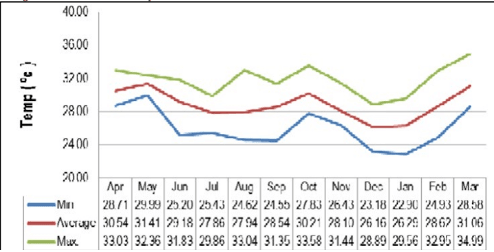
Based on the data recorded at the CAAQMS (Continuous Ambient Air Quality Monitoring Stations), for NMMC, the monthly average temperatures (Figure No.04) were recorded to be between 2 6 ° C to 3 1 ° C for the year 2017-18. The highest maximum average temperature of 3 1 . 4 ° C was recorded in the month of May (summer season) and the lowest temperature of about 2 6 . 1 ° C was recorded in the December month.
Figure 04: Month wise temperature in NMMC 2017-18.
[Source: Environment Status Report (ESR) 2017-18]
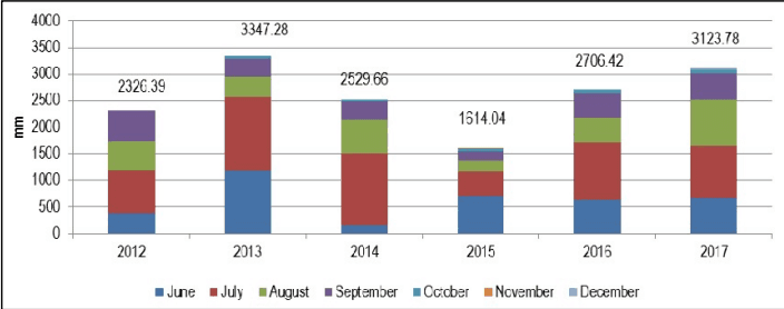
Figure 05: Decadal Trend of Annual Rainfall Recorded in Navi Mumbai.
[Source: Environment Status Report (ESR) 2017-18]
2.8 Wind:
Navi Mumbai is influenced by west, east and north-east winds. It is clear from the metrological data that, in general, the wind speed is least in Navi Mumbai in the month of October followed by November and December months. Wind speed increases slightly during the months of January to March and thereafter, rapidly from April to August months reaching the maximum value in June (47.96 MPH). It falls off very rapidly in September. Winds are generally moderate except during the south-west monsoon season when they are stronger.
[Source: Internet.]
CHAPTER3: Demo Graphic Characteristics