Document overview
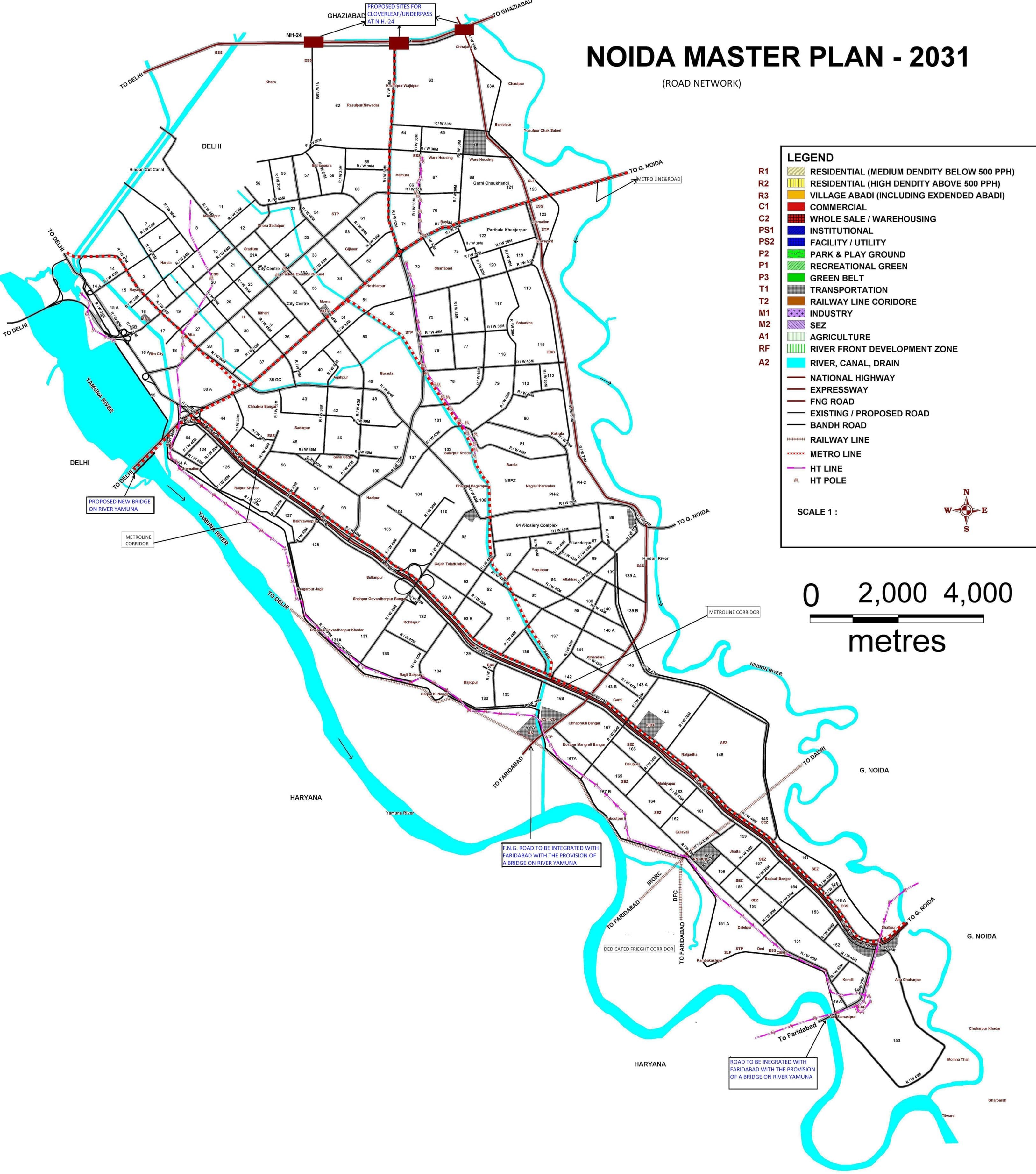
- Plan: Noida Master Plan — 2031
- Map theme: Road network
- Prepared by: New Okhla Industrial Development Authority (NOIDA) and N.C.R. Planning Cell, Town & Country Planning Department, Ghaziabad
- Source: User-provided map, page 1
Legend explained
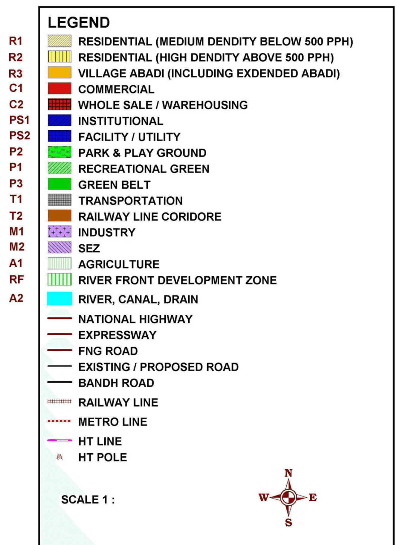
The map legend identifies land-use and transport-network categories.
Land-use and development codes
| Code | Map legend category | Plain-language explanation |
|---|---|---|
| R1 | Residential (medium density below 500 PPH) | Residential area with a stated density below 500 persons per hectare (PPH). |
| R2 | Residential (high density above 500 PPH) | Residential area with a stated density above 500 persons per hectare (PPH). |
| R3 | Village abadi (including extended abadi) | Existing village settlement areas, including extended abadi. |
| C1 | Commercial | Areas designated for commercial uses. |
| C2 | Whole sale / warehousing | Areas designated for wholesale activity and warehousing. |
| PS1 | Institutional | Areas designated for institutional uses. |
| PS2 | Facility / utility | Areas designated for facilities and utility services. |
| P2 | Park & playground | Areas designated for parks and playgrounds. |
| P3 | Recreational green | Areas designated as recreational green space. |
| T1 | Green belt | Areas designated as green belts. |
| T2 | Transportation | Areas designated for transportation-related uses. |
| T3 | Railway line corridor | Land or corridor associated with railway lines. |
| M1 | Industry | Areas designated for industrial uses. |
| M2 | SEZ | Special Economic Zone areas. |
| A1 | Agriculture | Areas designated for agricultural use. |
| RF | River front development zone | A riverfront development zone shown on the plan. |
| A2 | River, canal, drain | Watercourses and drainage features. |
Road, rail and metro symbols
The legend also identifies:
- National highway
- Expressway
- FNG Road
- Existing / proposed road
- Banking road
- Railway line
- Metro line
- HT line
- HT pole
The source map does not define every line style in detail. Check the applicable NOIDA planning documents for precise legal or engineering interpretations.
How to read the map
- Locate the sector, village, or area label.
- Trace nearby roads and connections to highways, expressways, and proposed roads.
- Match the area’s code or colour to the legend.
- Note nearby railway and metro corridors, high-tension (HT) lines, watercourses, drains, and the riverfront development zone.
- Before making a property or development decision, verify the applicable sector plan, latest approved master plan, road alignment, and authority records.
Scale, orientation and map notes
- Scale bar: 0–4,000 metres, as printed on the map.
- Orientation: A north arrow appears in the legend area.
- Village abadi: The map note says village abadi is indicative only and should be determined using actual field survey and revenue records.
- Notified-area boundary: The map note says the boundary is indicative and should be determined using relevant Gazette notifications. Consult the original map for the complete wording.
Source and limitations
This Markdown was prepared from the single-page map supplied by the user. Legend categories and codes are transcribed from the map image. Some small map labels and line-style details may not be legible at the supplied image resolution. This document explains the legend; it does not replace the official plan, regulations, or notifications.